
Trekking Navigation System using Opportunistic Communication
Yasuhiko Kitamura, Shunsuke Nosaka, Hirofumi Kishino and Yui Okuda
Department of Informatics, Kwansei Gakuin University, Sanda, Hyogo, Japan
Keywords:
Trekking Navigation System, Opportunistic Communication, Location Estimation.
Abstract:
Mountain climbing or trekking becomes popular in Japan recently. Unfortunately the more climbers go to
mountains, the more get lost. Handy GPS’s are a well-known tool to navigate climbers in the mountain area
by displaying their location on a digital map. They are useful to know the current location, but not suitable to
call an emergency help. Cell phones are useful to call a help, but they work only in the city area accessible
to mobile phone networks. They seldom get access to them in the mountain area. This paper proposes a
new trekking navigation system, which consists of mobile terminals and a server, that works even in the poor
communication environment where the Internet access is often disrupted such as in the mountain area. The
terminals can navigate climbers even when the Internet access is unavailable. When they can get access to the
server, they send the walking trajectory of the climbers, so the rescue party can locate the climbers in need.
They can also exchange the walking trajectory with each other by utilizing opportunistic communication
and carry the information until they reach an area accessible to the server. This paper shows a prototype
of trekking navigation system under development and how the opportunistic communication improves the
location estimation of climbers.
1 INTRODUCTION
A multi-agent system (Weiss, 1999; Wooldridge,
2009) consists of multiple agents that collaborate with
each other to solve a problem, and most of research
works presuppose the communication environment is
stable with a few notable exceptions (Durfee et al.,
1987). When the communication environment is not
stable, the agents need more intelligence to cope with
the delay and/or lost of messages to be transmitted
among them. In this paper, we propose a trekking
navigation system, which can be viewed as a multi-
agent system situated in a poor communication envi-
ronment, because the communication environment in
the mountain area is typically unstable.
Recently the population of Japanese mountain
climbers is more than 10 million and a number of
climbers get into trouble because of rapid weather
changes, going astray, injury, deconditioning, and so
on.
Handy GPS’s are widely used among climbers as
an IT tool to locate them in the mountain. The tool
measures the latitude and longitude of the current lo-
cation by using GPS (Global Positioning System) and
displays its location on a digital map. It is useful when
a climber needs to know his/her current location but
not suitable when he/she needs to inform his/her lo-
cation to a rescue party.
Recently many of climbers go to mountains with
cell phones. They work as a tool to call an emergency
help while they can get access to mobile phone net-
works, but they do not work in the large part of the
mountain area because the access to the mobile phone
networks is frequently disrupted. Figure 1 shows a
cell phone accessibility map along a trekking route in
Mt. Mino, Osaka, Japan. The accessibility frequently
changes depending on the terrain. In this paper, we
call such a communication environmentas Poor Com-
munication Environment (PCE) (Fujihara and Miwa,
2010; Vasilakos et al., 2012) where the Internet access
is frequently disrupted.
In this paper, we propose a new trekking naviga-
tion system, consisting of terminals and a server, that
can work in PCE with the following functions.
1. When the terminal is not accessible to the server,
it works as a stand alone navigator to inform the
current location to the user and records his/her
walking trajectory.
2. When the terminal is accessible to the server, it
sends the walking trajectory record stored in it to
the server.
3. When a terminal encounters another terminal,
they exchange their walking trajectory records
427
Kitamura Y., Nosaka S., Kishino H. and Okuda Y..
Trekking Navigation System using Opportunistic Communication.
DOI: 10.5220/0004326504270430
In Proceedings of the 5th International Conference on Agents and Artificial Intelligence (ICAART-2013), pages 427-430
ISBN: 978-989-8565-38-9
Copyright
c
2013 SCITEPRESS (Science and Technology Publications, Lda.)
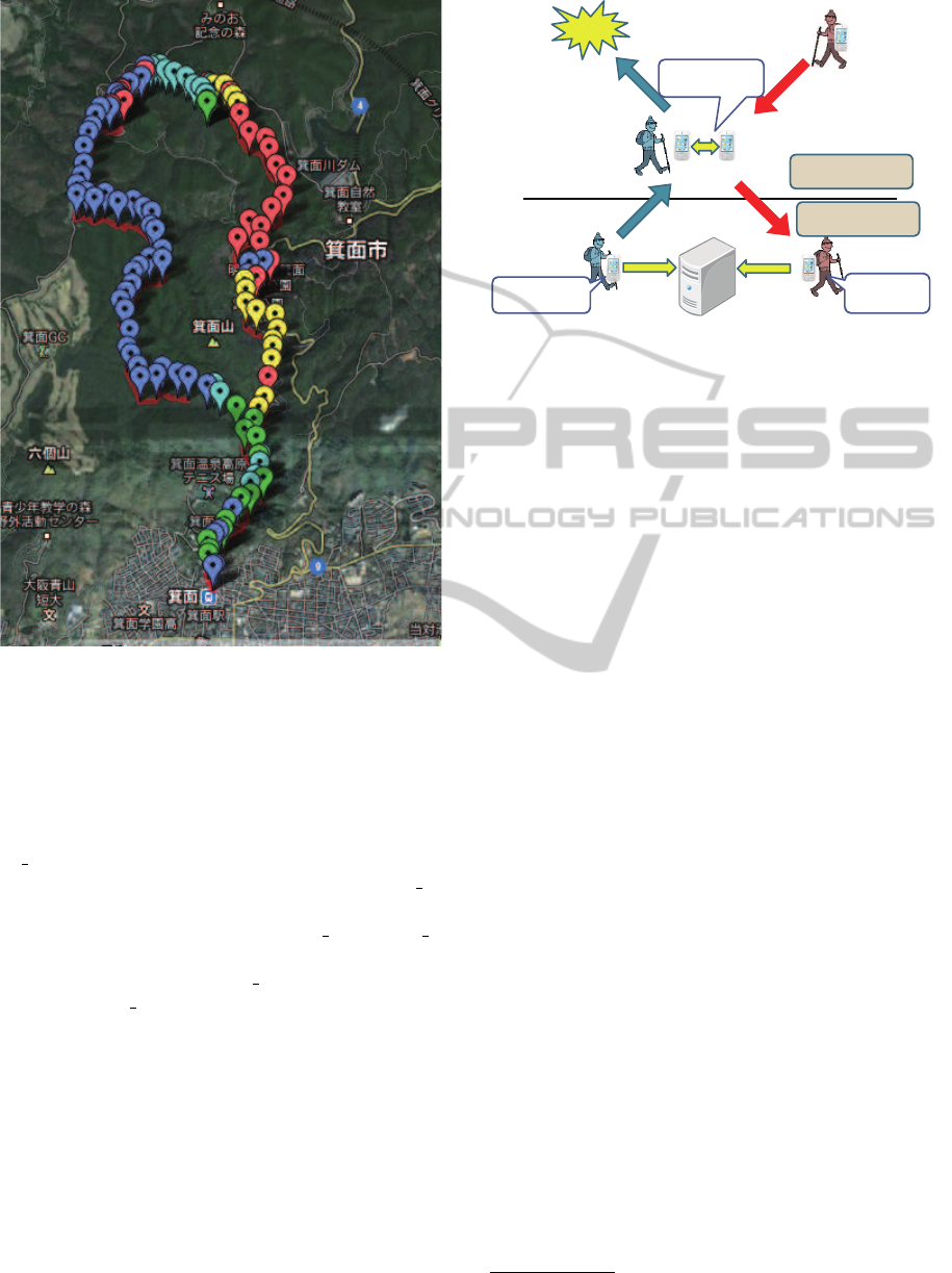
Figure 1: A cell phone accessibility map around Mt. Mino,
Osaka, Japan on August 8th, 2012. (Red: inaccessible, Yel-
low: very weak, Light blue: weak, Green: moderate, and
Blue: good).
with each other by using the P2P communication
link (Fujihara and Miwa, 2010).
Figure 2 shows how the system works. Terminal A
(T A) in an Internet accessible area sends its walking
record to the server. It encounters Terminal B (T B)
in the mountain area where no Internet access is avail-
able and exchanges the records with T B. When T B
reaches an Internet accessible area, it sends its records
together with the ones from T A to the server. If the
climber with T A get lost in the mountain, the res-
cue party goes to find him/her estimating his/her lo-
cation by referring to the walking records stored in
the server.
In this paper, Section 2 summarizes GPS applica-
tions for walkers and Section 3 shows a prototype of
our trekking navigation system developed as an An-
droid application and discusses how the estimation of
locating a lost climber is improved by using oppor-
tunistic communication. Section 4 summarizes this
paper with our future work.
Lost
Communication
is available.
Communication
is unavailable.
T_A and T_B
exchange their logs.
T_A sends the
log to the server.
T_B sends the
logs of A and
B to the server.
Climber A
Climber B
Server
Figure 2: Trekking navigation system in poor communica-
tion environment.
2 GPS APPLICATIONS FOR
WALKERS
Car navigation systems are a well known application
using GPS, but it can be applied for human walkers as
shown below.
Handy GPS’s. Garmin
1
has developed handy and
battery operated GPS’s to inform the current lo-
cation to the user for outdoor activities like moun-
tain climbing and trekking. The terminal works
offline, and digital maps have been installed to
show the location on its display without commu-
nication. The user can set the destination on the
map and the terminal navigates him/her to it. It
also shows the walking distance, average speed,
barometer, altitude, and so on. The maps can
be obsolete and the user requires to update them
manually.
Walking Navigation Systems. Walking navigation
systems are available as an application of
cell/smart phone and navigate users to a destina-
tion just like car navigation systems. After set-
ting a destination, the system shows routes de-
pending on the transportation such as train/bus,
car, or walk. It measures the current location by
using GPS, uploads the digital map around the
current location through cell phone networks, and
displays it on the screen. It navigates the user by
using speech synthesis and/or vibrations in a real-
time manner. It works online and the maps are
automatically updated to be the latest ones. It can
collaborate with other services such as shopping,
restaurant, and event recommendation systems.
1
http://www.garmin.co.jp/
ICAART2013-InternationalConferenceonAgentsandArtificialIntelligence
428

Real-time Locating Service. Japanese security
company Secom has commercialized a real-time
locating service to deal with social problems such
as kid napping, theft of cars and motorcycles,
wandering aged people, and so on. The service
utilizes a GPS terminal connected to a server
through cell phone networks. The user can locate
wandering people with the terminal through the
Internet. This service works only online.
Table 1 shows a comparison of GPS applications
for walkers. There are differences on how the digital
maps are stored on terminals, who are the target users,
and the quality of the communication environment.
Handy GPS’s are developed for users who enjoy
outdoor activities like mountain climbing, trekking,
and so on and are supposed to be used offline. The
digital maps have been installed manually in advance.
Handy GPS’s are stand alone systems that do not need
communication to the servers.
On the other hand, Walking Navigation Systems
suppose good communication environment and al-
ways work online. They are normally connected to
the servers, and they can download the digital maps
in need at any time.
The target users of Real-time Locating Service are
not ones who have the GPS terminal but the ones who
search for the one with the GPS terminal. The GPS
terminal does not have a display to show digital maps.
The system works in the good communication envi-
ronment because communication links between ter-
minals and servers should be stable to know the loca-
tion of the terminals.
The conventional systems mentioned above are
not suitable in PCEDHandy GPS’s caninform the cur-
rent location to the climber but they cannot inform it
to the rescue party when the climber gets lost. Walk-
ing Navigation Systems and Real-time Locating Ser-
vice suppose the good communication environment
and they cannot work properly in the PCE like the
mountain areas. We propose a new walking naviga-
tion system that navigates the user as a stand alone
system even when the Internet access is unavailable
and sends walking records to the server, when the In-
ternet access is available, to inform the location of the
climber to the rescue party in need.
It is difficult to estimate the location of the climber
when the Internet access is unavailable for a long
time. As a remedy, we utilize opportunistic commu-
nication based on the P2P access between the termi-
nals. When a terminal encounters another, they ex-
change the walking records with each other. When
the terminal reaches an area where the Internet access
is available, it sends not only the walking record of
the terminal but also ones of the other terminals that
it has encountered. This leads to a better location es-
timation of the climbers.
3 TREKKING NAVIGATION
SYSTEM IN PCE
We are developing a new trekking navigation system
that works on a smartphone. It works without the In-
ternet access in PCE like the mountain area, because
digital maps have been installed in it. It measures
the latitude, the longitude, and the altitude of the cur-
rent location in a constant interval by using GPS and
displays the current location on the digital map. It
also measures the signal strength of mobile phone net-
works.
The terminal records the walking trajectory and
sends it to the server when the Internet access is avail-
able. It exchanges the record with the other terminal
through Bluetooth when it encounters the other ter-
minals. When the climber with the terminal gets lost,
the rescue party gets access to the server to estimate
the location of the climber referring to the walking
record.
We performed a simulation experiment to show
how opportunistic communication improve the trace-
ability of climbers. We model walking routes as a grid
world shown in Figure 3. Climbers repeat to walk
between S and G at a constant speed. It takes 200
steps to go to G and to return to S. When a climber
reaches a branch, he/she takes a route closer to the
destination. If there is a tie between two routes, he/she
chooses one at random. We record the history of en-
counters among climbers and calculate the traceabil-
ity of climbers depending on the number of climbers
in the area. Figure 4 shows a result of the simula-
tion. X-axis shows the location on route and Y-axis
shows the estimation of the location. Climbers start
from S(0%), go to G(50%), and return to S(100%).
“Ideal” means the estimation when the Internet access
is always available, and it is correct at every location
on the route. When we assume the Internet access is
available only at S, the estimation becomes incorrect
except at S. The difference becomes large when the
number of climbers is few.
4 SUMMARY AND FUTURE
WORK
We proposed a new trekking navigation system that
works even in the poor communication environment
where communication links are frequently disrupted.
TrekkingNavigationSystemusingOpportunisticCommunication
429
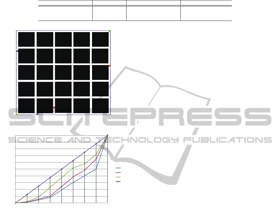
Table 1: Comparison of GPS applications for walkers.
Handy GPS Walking Navigation Systems Real-time Locating Service
Digital maps on terminal Manually stored Downloaded None
Users Terminal holders Terminal holders Searchers
Communication environment
Bad Good Good
G
S
Figure 3: The simulation model of walking routes.
0
10
20
30
40
50
60
70
80
90
100
0%(S) 25% 50%(G) 75% 100%(S)
esmaon
locaon on route
n=10
n=30
n=50
ideal
Figure 4: Result of simulation.
When the communication link is unavailable, the sys-
tem navigate the user by using GPS and digital maps
as a stand alone system and records the walking tra-
jectory in the terminal. When the terminal gets access
to communication networks, it sends the record to the
server. If the user gets lost, the rescue party can esti-
mate his/her location referring to the record stored in
the server. We show that the estimation is improved
by using opportunistic communication among the ter-
minals.
We have already developed a prototype system
with the navigation function as an Android applica-
tion and plan to install the communication function
to the server and the P2P communication function
through Bluetooth. We have showed that how oppor-
tunistic communication improve the location estima-
tion by using an schematic example, but we need to
further evaluate the effect changing parameters such
as the complexity of mountain routes, the frequency
of encounters among climbers, the signal strength in
the mountain, and so on.
From a view of the terminal autonomy, how to
conserve the battery is an important research issue.
The more frequently the opportunistic communica-
tion happens, the more the battery is consumed be-
cause the amount of data communication to exchange
walking records increases. We need to develop a
scheme to selectively exchange the records. Our
trekking navigation system can be viewed as a multi-
agent system consisting of autonomous behaviour to
navigate the user considering the battery consump-
tion and collaborative behaviour to share the walk-
ing records. How to coordinate the terminals with
a constraint of battery consumption is an interesting
research topic of multi-agent systems.
ACKNOWLEDGEMENTS
This work is partly supported by JSPS KAKENHI
Grant Number 21300057 and MEXT-Supported Pro-
gram for the Strategic Research Foundation at Private
Universities.
REFERENCES
Durfee, E. H., Lesser, V. R., and Corkill, D. D. (1987).
Coherent cooperation among communicating prob-
lem solvers. IEEE Transactions on Computers,
C36(11):1275–1291.
Fujihara, A. and Miwa, H. (2010). Scaling relations of
data gathering times in an epidemically data sharing
system with opportunistically communicating mobile
sensors. Intelligent Networking, Collaborative Sys-
tems and Applications, Studies in Computational In-
telligence, 329:193–206.
Vasilakos, A. V., Zhang, Y., and Spyropoulos, T. (2012).
Delay Tolerant Networks, Protocols and Applications.
CRC Press.
Weiss, G. (1999). Multiagent Systems. MIT Press.
Wooldridge, M. (2009). An Introduction to MultiAgent Sys-
tems. Wiley.
ICAART2013-InternationalConferenceonAgentsandArtificialIntelligence
430
