
DEVELOPMENT OF AN OPTIMIZATION MODEL
FOR IMAGE COLLECTION PLANNING
Jinbong Jang, Jiwoong Choi and In-Chan Choi
Department of Industrial Management Engineering, Korea University, 1, 5Ka, Anamdong,
Seongbookku, Seoul 136, Republic of Korea
Keywords: Satellite image collection planning, Scheduling, Optimization.
Abstract: Customer service requests for satellite-based image collection rapidly grow in Korea as the number of
available satellites increases. The customer requests must meet their due dates under several complicating
conditions, such as memory capacity limits, weather conditions, role tilts and segment conflict resolutions.
In this paper, we address this problem by presenting a mixed-integer program model and propose an
investigative solution approach that handles millions of segment conflict resolution constraints. The
proposed approach would reduce the model size to improve its solvability by utilizing a new redundancy
checking pre-processing technique.
1 INTRODUCTION
Since the first satellite was launched, satellite
imagery service has been applied to various practical
areas, including meteorology, agriculture, forestry,
geology, regional planning and warfare.
In recent years, customer service requests for
satellite-based image collection rapidly grow as the
number of available satellites increases. Such ever-
growing requests, which cause major complications
in planning, bring several challenges to service
providers who try to satisfy customer demands as
much as possible. One of the challenges in a satellite
image collection process is to build an image
collection schedule so as to minimize the delays in
the service requests while multiple parameters and
constraints, such as memory capacity limits, weather
conditions, role tilts, segment conflict resolutions
and due dates, must be satisfied. Because of the
complexity of the problem, it is essential to build a
fully automated scheduling system, which utilizes
optimization models and algorithms.
This paper is organized as follows. In section 2,
related works are presented. In section 3, a brief
description of the problem and parameters in the
satellite image collection planning is provided. In
sections 4 and 5, a mathematical formulation and a
solution approach for it are presented, respectively.
Concluding remarks along with future studies are
provided in the last section.
2 RELATED WORKS
Over the years, the satellite image collection
planning has been well-studied. Some of the studies
in literatures, which are pertinent to this study, are as
follows. Vasquez and Hao (2001) generalized
satellite image collection planning as a variation of
the knapsack model and proposed a tabu search
algorithm. Bianchessi et al (2007) developed tabu
search algorithm for a multiple satellite and multiple
orbit problem. Gabrel and Vanderpooten (2002)
formulated a model as a selection of multi criteria
longest path in a directed acyclic graph. Wolfe and
Sorensen (2000) presented a description on the earth
observation system for NASA.
3 SATELLITE IMAGE
COLLECTION PLANNING
The satellite image collection planning builds an
optimal schedule to handle the customers’ requests
in an efficient manner. The schedule has to be
designed by taking various scheduling parameters
and assumptions into account. Because of a large
number of parameters and constraints to consider,
the construction of an optimal schedule for the
satellite image collection planning becomes a
complicated task. In addition, a general reference
171
Jang J., Choi J. and Choi I..
DEVELOPMENT OF AN OPTIMIZATION MODEL FOR IMAGE COLLECTION PLANNING.
DOI: 10.5220/0003759701710174
In Proceedings of the 1st International Conference on Operations Research and Enterprise Systems (ICORES-2012), pages 171-174
ISBN: 978-989-8425-97-3
Copyright
c
2012 SCITEPRESS (Science and Technology Publications, Lda.)
model is not available in literature for accommodat-
ing different situations.
3.1 Problem Description
The satellite image collection planning problem
aims at maximizing daily collections. The collected
images must meet each customer’s requirements on
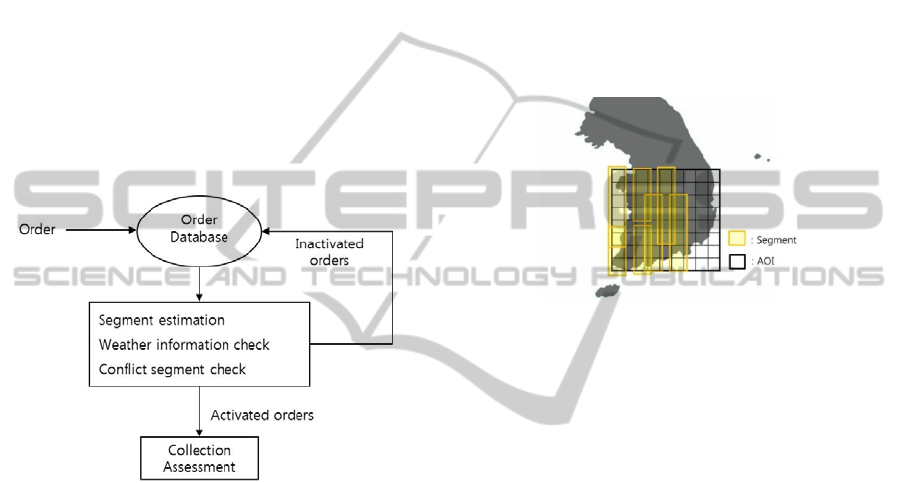
picture quality. Figure 1 shows how the image
collection planning system under consideration
works.
All customers’ requests are put in the order
database, and the process handles them as an input
data. After image collection planning process is
done by checking all steps, the activated orders are
passed to the collection assessment. The inactive
orders will remain in the order database for a future
use.
Figure 1: Image collection planning process.
All satellite image collection orders have
specifications on order priorities, maximum cloud/
snow cover limits, due dates and roll tilts. All these
order parameters are employed as an input to the
automated scheduling system. The orders are
assigned to the schedule while maintaining the
memory consumption limit and the segment conflict
resolutions. Currently, the process is carried out
manually by human experts.
The detail information of the parameters and the
memory consumption limit are provided in the next
subsection.
3.2 Parameters
Six parameters are considered as major factors in the
satellite image collection planning.
3.2.1 Memory Consumption Limit
The memory consumption limit is a constraint which
enforces the overall memory usage between two
consecutive download stations not to exceed
satellite’s memory size.
3.2.2 Segment
The segment is defined as a possible geographical
section to collect images. The set of segments is
determined prior to build a scheduled plan. A
geometrically large order which is called Area of
Interest (AOI) consists of many segments (Figure 2).
In order to collect all images of an AOI, the image
collection task may span several months to complete
(Martin, 2002).
Figure 2: The Area Of Interest (AOI) (bold black box)
consists of the segments (yellow box).
3.2.3 Priority
A higher priority request must be carried out prior to
a lower one. The priority condition can be satisfied
by sequentially optimizing problems from the
highest priority to the lowest priority.
3.2.4 Weather Condition
Two kinds of weather conditions, cloud and snow
cover, are considered. It is essential to consider
maximum cloud and snow cover limit at the same
time. Collected images with unacceptable cloud/
snow cover must be recollected (Martin, 2002).
3.2.5 Roll Tilt
High quality images are in general obtained when
the camera is positioned at a low angle. Client’s
orders have acceptable intervals of angles so that
only segments which satisfy the angle condition
must be scheduled.
3.2.6 Due Date
Each request has to be finished before its deadline.
ICORES 2012 - 1st International Conference on Operations Research and Enterprise Systems
172

4 MATHEMATICAL
FORMULATION
In a recent paper, Baek et al (2011) regarded the
satellite mission scheduling problem as a knapsack
problem. In this paper, we present a formulation in
which the assignment and the knapsack constraints
both are considered. Two assumptions are made to
derive our formulation and a solution approach.
- All orders can be carried out in a given
planning horizon. That is, the problem has at least
one feasible solution
- Every inter-image-collection epoch has the
same length
The epoch is defined as a time interval between
two consecutive stations on earth for memory
download.
Figure 3: Graphical representation of model.
The following is the formulation for the satellite
image collection planning problem.
Mimimize
ξ
(1)
subject to
,
jj
td jJ
ξ
≥− ∀∈
(2)
, , ,
jiik j
tfx iIkKjJ≥∀∈∀∈∀∈
(3)
1,
ik
iI
x
kK
∈
=∀∈
∑
(4)
,
i
kik
kP
ax MR i I
∈
≤∀∈
∑
(5)
1, ( , ) ,
ik ik
x
xkkCiI
′
′
+≤ ∀ ∈ ∀∈
(6)
{0,1}, ,
ik
x
iI kK∈∀∈∀∈
(7)
0,
j
tjJ≥∀∈
(8)
Notations:
: epoch index,
: AOI index,
: segment index,
iiI
jjJ
kkK
∈
∈
∈
The objective of the model is to deliver collected
images before the due dates. Constraints (1)-(3)
assure the minimization of the maximum lateness of
the orders. Constraint (4) ensures that the segments
are assigned to one of the epochs. The memory
consumption limit for each epoch is considered in
(5). As the image collection requires a set-up time,
conflicts can occur if the moving time between two
consecutive segments is less than the set-up time.
The conflicts are prevented by constraint (6).
The formulation above can be used to obtain
optimal schedule. However, for practical scheduling
problems, millions of segment conflict resolution
constraints reduce the solvability of the problem. In
section 5, we present an investigative solution
approach to handle enormous number of constraints.
5 SOLUTION APPROACH
The mathematical model (1)-(8) has two types of
constraint structures. First, constraints (4)-(5) can be
transformed to an assignment structure by
introducing slack variables. Second, constraints (5)-
(6) have the knapsack structure. The auction
algorithm and dynamic program are well-known
solution approaches for the assignment problem and
the knapsack problem, respectively. It is possible to
develop a Lagrange-relaxation based algorithm by
utilizing the two kinds of constraint structures and
the corresponding algorithms.
Prior to an algorithm development phase, we
explore applicability of a pre-processing procedure
which reduces the number of constraint to improve
the solvability of the problem. The mathematical
model (1)-(8) contains a large number of knapsack
constraints (5)-(6). Especially, the number of
constraints (6) may exponentially explode depending
on AOI structure.
Because the knapsack structure is dominant the
model, the pre-processing procedure given by Choi
and Choi (2011) can be employed. Their procedure
identifies redundancy in multi-dimensional knapsack
: memory capacity
: a set of segments for ,
: a set of segments that can be allocated to epoch
:completion time of epoch
: due date of
jj
i
i
j
M
R
KAOIjJKK
P
iI
fiI
dAOIjJ
∈⊂
∈
∈
∈
: amount of memory required for segment
: completion time of image collection for
: a set of a pair of conflict segments, ( , ),
, ,
k
j
akK
tAOIjJ
Ckk
kKk Kkk
∈
∈
′
′′
∈∈ <
DEVELOPMENT OF AN OPTIMIZATION MODEL FOR IMAGE COLLECTION PLANNING
173
constraints. This approach utilizes the concept of
constraint intercepts in Paulraj et al (2006) and
extends it by using surrogate constraints. They
construct feasibility problems in which constraint
redundancy can be detected. Then, they suggest a
O(n
3
) heuristic algorithm for solving the feasibility
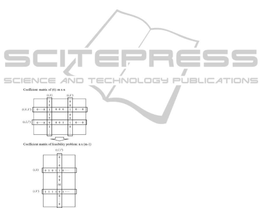
problems. To identify redundancy in constraints (6),
we consider the following feasibility problem:
The (i, k, k
'
) constraint of (6) is redundant if and
only if feasibility problem (9) has any feasible
solution
(, , ')
0, 0, 0
λλ λ
≤≥ >
ikk T
Fe (9)
where
(, , ')
{0,1, }=−
ikk
pq
F
M
[
]
1
:
T
m
λ
λλ
= L
[
]
:1 1= L
T
e
: =
M
BigM value
Figure 4: Matrix pattern of coefficient matrix of (6) and F.
The coefficient matrix F consists of components
with 0, 1 and -M values and the matrix pattern
follows the 0-1 component pattern of A
T
(A:=
coefficient matrix of (6)). These structures can be
utilized in developing an algorithm for solving the
feasibility problem. Moreover, the above described
redundancy checking procedure can be applied to
constraint (5) in a similar fashion.
6 CONCLUSIONS
In this paper, we presented a mathematical model for
the satellite image collection planning. The
presented model deals with long term planning and
reflects real-world constraints in practice. We also
proposed an investigative solution approach that
utilizes a new redundancy checking pre-processing
technique. It remains to be seen through a further
study on computational experiments whether the
proposed approach results in a high-quality schedule
for the satellite image collection.
ACKNOWLEDGEMENTS
This work was supported by 2010 technology
royalties program (Technical Development of
Optimized Image Collection Planning for Multi-
Satellite) of The Ministry of Education, Science and
Technology.
REFERENCES
Baek, S. W. et al., 2011. Development of a scheduling
algorithm and GUI for autonomous satellite missions.
Acta Astronautica 68.
Bianchessi, N., Cordeau, J. F., Desrosiers, J., Laporte, G.,
Raymond, V., 2007. A heuristic for the multi-satellite,
multi-orbit and multi-user management of Earth
observation satellites. EJOR, Vol.177, No. 2.
Choi, J. W., Choi, I. C., 2011. Identifying redundancy of
multi-dimensional knapsack constraints using
surrogate constraints. Working Paper, Korea
University.
Gabrel., V., Vanderpooten, D., 2002. Enumeration and
interactive selection of efficient paths in a multiple
criteria graph for scheduling an earth observing
satellite. EJOR, Vol. 139, No. 3.
Martin, W., 2002. Satellite image collection optimization.
Optical Engineering. Vol. 41, No.9.
Paulraj, S., Chellappan, C., Natesan, T. R., 2006. A
heuristic approach for identification of redundant
constraints in linear programming models,
International Journal of Computer Mathematics. 83.
Vasquez, M., Hao. J., 2001. A "Logic-Constrained"
Knapsack Formulation and a Tabu Algorithm for the
Daily Photograph Scheduling of an Earth Observation
Satellite. Computational Optimization and
Applications, Vol. 20, No. 2.
Wolfe., W. J., Sorensen, S. E., 2000. Three Scheduling
Algorithms Applied to the Earth Observing Systems
Domain. Management Science, Vol. 46, No.1.
ICORES 2012 - 1st International Conference on Operations Research and Enterprise Systems
174
