
THE DEVELOPMENT OF A WEB MAPPING SYSTEM AND ITS
APPLICATION
Balqies Sadoun, Omar Al-Bayari and Samih Al-Rawashdeh
Surveying and Geomatics Engineering Department, College of Engineering
Al-Balqa’ Applied University, Al-Salt 19117, Jordan
Keywords: Web mapping, Neogeography, Mapsever, e-based systems, Web 2, AspMap, Tracking systems.
Abstract: Recently, there is increase interest in web mapping applications due to the increase use of mobile
application, GPS, and digital mapping. The change in the web-based communities, applications and
services, from Web 1.0 “read” only technologies to Web 2.0 “read”, “write” and “build” technologies
opened a new heaven for public usage and applications. Neogeography (also called Volunteered Geographic
Information), came with the increase interest in online mapping and in using geospatial technologies in
diverse applications. The development started by mashing up various web resources to create maps. This
has improved the web mapping/GIS services despite some difficulties. The open source initiative came
(Minnesota Mapserver, GDAL/OGR, GRASS GIS and PostgreSQL/PostGIS packages), in order to offer a
technically competitive and open-source alternative solution to the commercial software for web mapping
and GIS system applications. GIS and mapping software companies have developed certain development
kits that could be used to build a complete GIS and web mapping applications at a very low cost, They also
offer a large wide library to be used in developing GIS applications. In this work, we used one of these
applications (AspMap) in order to develop our web mapping software. AspMap is a set of high-performance
Web mapping components and controls for embedding maps in ASP.NET and ASP.NET AJAX
applications. AspMap gives the ability to generate maps, thematic mapping, routing, vehicle tracking and
other features that are generated on the server to make maps fully interactive on the client-side. AspMap
provides the functionality needed by the user. In this paper, we present a new web–based system named,
JOFAST, in order to provide desktop navigation (shortest path), tracking, locating land parcels, distance
calculation, map creation, among others. The system is flexible, efficient, easy to use and cost-effective and
it is in use now in the city of Amman in Jordan.
1 INTRODUCTION
The second generation of web-based communities,
applications and services (Web 2.0) are different in
the ways software developers and end users use the
Web (Wikipedia, 2008b). The changes are presented
in the creativity, the collaboration, and the usage of
the Internet and the Web as platforms (O’Reilly,
2005) so the user can generate and distribute the web
contents. Neogeography is becoming popular and it
is utilizing various web resources to create maps
(Wyngaarden and Waters, 2007). This came due to
vast amount of public interest in online mapping and
using geospatial technologies in different domains.
A mashup is a website or web application that
uses contents or services from many sources to
create a new service (Wikipedia, 2008a). Map
mashup has great potential to improve and facilitate
the development of the future web mapping/GIS
services such as participatory GIS and e-government
services, navigation and tracking. However, issues
related to privacy and ownership protection are still
to be solved.
Developing a mashup in general faces many
difficulties (Li and Gong, 2008). These include
difficulties in integrating the local data into new
applications and the way to use it; protection of
intellectual property and consumer privacy versus
fair-use and the free flow of information (Merrill,
2006). Other kinds of problems concerning security
measures in mashups and the integration of map data
sources and services with other types of data sources
and services.
What is a mashup? Ramsey stated in (Ramsey,
2006) that “most mashups make use of a base map, a
22
Sadoun B., Al-Bayari O. and Al-Rawashdeh S..
THE DEVELOPMENT OF A WEB MAPPING SYSTEM AND ITS APPLICATION.
DOI: 10.5220/0003684900220028
In Proceedings of the International Conference on e-Business (ICE-B-2011), pages 22-28
ISBN: 978-989-8425-70-6
Copyright
c
2011 SCITEPRESS (Science and Technology Publications, Lda.)

geocoder, and a Web interface.” Pietroniro and
Fichter (Pietroniro and Fichter, 2007) defined a Map
mashup as a way to combine map data source or
service with added information, often geo-
referenced to the map data in order to create a new
map.
The statistics of various mashups created up to
April 2008 shows that the map-based mashup
accounts for around (39%) of all the registered
mashups. With the decrease of requirements for
programming skills and the increased number of
mashup editors and creation tools, creating map
mashups have become easier to develop.
The Open Source Initiative (OSI) (OSI - Open
Source Initiative) for GIS Software such as
Minnesota Mapserver, GDAL/OGR, GRASS GIS
and PostgreSQL/PostGIS packages, offer a
technically competitive and open-source alternative
solution to the commercial software. The OSI is
growing in popularity in order to provide the
solution to web mapping services using open source
GIS software (Song et al., 2004). The OSI allows
using, modifying and redistributing the software
freely. It breaks the cost barriers to using the public
spatial data and the GIS tools in building a large-
scale GIS system. As long as people have problems
to solve and the spirit to share their solutions, open
source will continue to grow and contribute to the
geo-informatics community (Ramsey, 2002). The
development of OSI software needs to control the
interaction between OSI software, the performance
of the integrated system and the function limitations.
The Mapserver is not a full-featured GIS system, but
provides enough core functionality to support a wide
variety of web applications and can handle a huge
Geodata base (Raghavan et al., 2002).
There has been an increase interest in Web
mapping application in recent days due to the many
features of Web mapping such as increase use of
mobile application, GPS, and digital maps.
Most of the available GIS software has already
modules for web mapping. Moreover, these software
packages offer the possibility to develop web
application using their developing kits. Open source
program allows the creation of the web applications,
but there is no support for such applications.
Other GIS and mapping software have developed
a certain development kits, which could be used to
build a complete GIS and web mapping applications.
Such development kits have low cost and offer a
large wide library to be used in developing a GIS
application. We used one of these applications, the
AspMap, to develop our web mapping software
system.
AspMap is a set of high-performance, Web
mapping components and controls for embedding
maps in ASP.NET and ASP.NET AJAX
applications. AspMap gives the ability to generate
maps, thematic mapping, routing, vehicle tracking
and other features that are generated on the server in
order to make the maps fully interactive on the
client-side. AspMap provide the functionality you
need to turn the occasional visitor to your site into a
regular user. It provides functionality to a local
government web site, a real estate web site, a
navigation website, a vehicle tracking web site, or to
a location-based services.
2 WEB MAPPING
Web mapping is the process of designing,
implementing, generating and delivering maps on
the World Wide Web. While Web Mapping
primarily deals with technological issues, Web
Cartography additionally studies theoretic aspects
such as the usability of web maps, the evaluation
and optimization of techniques and workflows, the
social aspects, and more. Web GIS is similar to web
mapping, but with an emphasis on analysis,
processing of project specific geodata and
exploratory aspects. Web maps are often a
presentation media in web GIS. With time web maps
are increasingly gaining analytical capabilities.
These days both web mapping and web cartography
have to deal with interactivity, usability and
multimedia issues.
The use of the web as a distribution medium for
maps is a major advancement in cartography and
opens many new opportunities (real-time maps). A
first classification of web maps has been made by
Kraak (Kraak and Brown, 2001). He distinguished
static and dynamic web maps and further
distinguished view-only and interactive web maps.
Cartography was restricted to special groups,
requiring expensive and complex hard, software,
skilled cartographers and geomatics engineers. The
cheap and easy transfer of geodata across the
Internet have allowed the integration of distributed
data sources and opened new opportunities to non
specialized general public to join the web mapping
world. Hence, educating the general public about
geographic analysis and cartographic methods and
principles should be a priority.
In this work, we present a website based on
AspMap for GIS applications such as navigation,
tracking and map creation. We provided the website
with Amman city streets network and satellite image
THE DEVELOPMENT OF A WEB MAPPING SYSTEM AND ITS APPLICATION
23
to allow low cost navigation, Tracking and many
other functions such as maps, shortest path, and
parcel location, for the city of Amman are provided.
The created website can provide more added
functions for city planning services. Many other
important byproducts such as GIS database for the
Jordanian roads network, Amman streets network
were implemented for the sake of the website
application. The database attributes for the
application (shortest path, navigation, tracking, etc.)
are based on NAVTEQ Data. NAVTEQ has
developed exceptionally rich attributes to give life
and intelligence to its database. Navigation uses
special attribute data for effective navigation. In all,
204 attributes are organized into 14 categories I
order to describe the essential qualities of a map,
which are needed to provide useful map display, and
enable route planning and guidance for tourist
information or to advanced driver assistance
systems.
We also used the low price handheld GPS
receivers to collect POI to be update the existing
data.
3 THE METHODOLOGY
The methodology includes two important parts
which are the GIS and website creation as described
below.
GIS Creation:
We start by building a GIS for the city of Amman so
that it will be posted on our website for the public
utilization in navigation, tracking and parcel locating
using ARC GIS professional 9.2 software. The
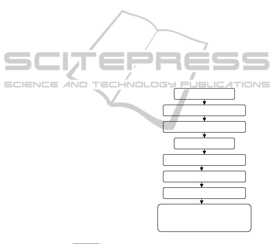
flowchart in Figure 1 illustrates the methodology for
the design of the GIS data model. Data collection of
all types such as shape files, database tables, satellite
images, digital maps, and paper maps, was needed in
order to be utilized in creating the needed layers
(TIN, Raster….etc.).
The data used has info about: (a) Amman
topographic map (scale 1:50000) paper map, (b)
Amman satellite image and (c) NAVTEQ
data.
Next, we built a GIS system as follows.
- Scanning: “Conix“ scanner 200dpi resolution and
(jpg) Format was used at first. After the maps
registration, we found large RMS values and
distortion caused by the lens of optics, hence, we
rescanned the maps using 400dpi resolution, and got
satisfying results RMS (1-3 m).
- Registering: The coordinates system of maps is
JTM, but our project is based on UTM coordinate
standard, so we transformed the control points (grid)
from JTM to UTM using the GeoMedia
Professional.
- Digitizing: We used the ArcGIS (ArcMAP) in the
digitizing process to create the needed layers.
- Editing: This is meant to edit errors occurred due
to digitizing process.
- Adding attribute Data to Each Layer: Here, we
added the following attributes: (a) Jordan
governorates boundaries, (b) ID; Governorates
names, (c) Sub-districts boundaries, (d)ID; Sub-
district names, (e) Jordan roads network, (f) ID;
Jordan roads network names, (g) Amman streets
Network, and (h) ID; Amman streets network
names, length, speed limit, ramp, etc.
- Creating the Road Network: By using GIS (Asp
map) and the needed attribute data we created the
road network (see Figure 2) for the website and the
application of navigation and tracking. AspMap
always loads the road network into memory before
doing any calculations.
Figure 1: Flowchart of the GIS Methodology.
- Output Layers: The created GIS had four basic
layers which are: Jordan Governorate Layer, Sub
district Layer, Jordan Roads Network Layer, and
Amman Streets Network layer
Data Acquisition
Scannin
g
ma
p
and Editin
g
Registration and Projection
Digitizing
Adding Attribute data
Build Road Network
Jordan Road Network layer (line)
Jordan Government layer (polygon)
Jordan sub-Gov. layer (polygon)
Out put
ICE-B 2011 - International Conference on e-Business
24
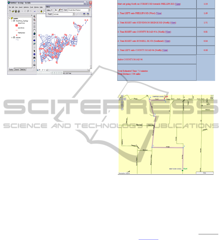
Figure 2: Jordan Roads NetWork.
4 WEB MAP (JOFAST)
CREATION
This is the second and important part of our work.
We designed a web site and name it (JOFAST), for
Navigation and Tracking applications. The purpose
is to serve interested groups, in their geomatics
applications at a low cost in a low income country.
We tried to provide our website with some
needed and available navigation and tracking
functions, in addition to locally needed functions
such as parcels location. In the following we will
present the different functions:
- The Shortest Path Function: For this procedure,
we need to select the start point, the end point (using
drop-down menu), the unit distance (Miles,
Kilometers), the strategy to find Route by typing
(Quickest, Shortest), and optional select projection
type. Then we click on “find route.” Figure 3
presents the obtained results. If we click on (view)
this road will be displayed on the map (Figure 4).
-Tracking: Vehicle tracking and navigational
systems have brought GPS applications to the life of
the public. Automatic Vehicle Locating System
(AVLS) (Al-Bayari and Sadoun, 2005), Vehicle
Tracking and Information System (VTIS), and
Mobile Asset Management System (MAMS), offer
an effective tool for improving the operational
efficiency and utilization of vehicles. Simple
Tracking systems present the concept of tracking
systems and works as a simulator to demonstrate to
users the meaning of a tracking system and how it
works along with its advantages and effectiveness
(Figure 5).
Figure 3: Summary of the Quickest Route Report.
Figure 4: The Shortest or Quickest Route Map.
Our tracking function operation can be summarized
as follows. (1) Auto-refresh which means updating
the location of the car every interval chosen by the
user. (2) Interval to receive location update info
which means the update time used to receive
location of a car (0.5 sec) means receive location
info by (SMS or GPRS) every 0.5 sec. Our tracking
system is based on the dynamic layer (GeoEvent
function). A GeoEvent
is a moving object. Examples
include vehicles, aircrafts, and satellites systems. If
the user wishes to track and display on the map.
Then the GeoEvents in the Animation Layer may be
refreshed without reloading the map image. The user
can utilize the animation Layer and GeoEvent
objects to track and display the location of a vehicle
in real-time.
JOFAST is our designed website system (Figure
9) for desktop Navigation systems (shortest path);
Tracking Systems (simple tracking) and Parcel
Searching for the city of Amman in addition to data
for the entire world published using AspMap. The
THE DEVELOPMENT OF A WEB MAPPING SYSTEM AND ITS APPLICATION
25
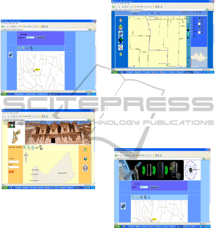
dynamic website, which is connected with an access
database, has ability to publish video. It has been
used by several groups in Amman.
Figure 5: A Simple Tracking System.
Figure 6: JOFAST Website.
Website Requirements:
The major Software requirements are: Operation
system, Windows XP service pack 3 Minimum
configurations, Pentium, 2.2 GHz, 1GB RAM,
Window Server 2003, Frameworks 3.5 and File
System. Hardware requirement is any local area
network. The website has the ability to define the
shortest path, display a map with multiple layers
(cities, roads, rivers and boundaries) and display
locations stored in a database in addition to
navigation and tracking functions.
Functions of the website include the followings.
- Desktop Navigation: Figure 7 presents the
navigation system in Amman as an application
(Shortest path). This webpage includes the type of
projection used; Asp Map provides a large number
of projections.
Figure 7: The Desktop Navigation.
- Tracking System:
The system is based on receiving the signals from
satellites by GPS receivers fixed on the vehicle and
connected by a GSM modem. The mentioned
hardware sends the acquired data by a Short
Message Service (SMS). The SMS carries certain
information about the geographic position of a
certain vehicle to the control center. Figure 8,
presents a tracking system as a simulator on the web
site (simple tracking).
Figure 8: The Complete Tracking system.
Asp Map allows you to display locations of
moving objects without reloading the page or the
map image (ASP Map uses AJAX to update the
locations). The locations should be updated in a
Refresh Animation Layer event handler. After the
Refresh Animation Layer event handler is executed,
further processing of the page will be stopped and
the locations will be sent to the browser. To track the
location of a vehicle, you need to set the Enable
Animation property of a Map control to True
position. Use the Animation Interval property to set
ICE-B 2011 - International Conference on e-Business
26
an update interval. Add an event handler for the
Refresh Animation Layer event. Add the current
location of a vehicle to the Animation Layer object
of the Map control. You can display the previous
movements of the vehicle as a line using the Path
property of the GeoEvent class. If the current
location of the vehicle is outside the map, you can
move the map to a new position using the “Center
At method.” After that, you can set the “Need
Refresh Map” property of the Refresh Animation
Layer Args class to True. This way, the map image
will be refreshed without reloading the page. Auto-
refresh means update location of the car every
interval you choose. The tracking system uses
dynamic layer (GeoEvent function). A GeoEvent is
a moving object you wish to track and display on the
map. Examples of geoevents are vehicles, aircrafts,
and satellites. GeoEvents in the Animation Layer
may be refreshed without reloading the map image.
The user can use Animation Layer and GeoEvent
objects to track and display, for example, the
location of a vehicle in real-time.
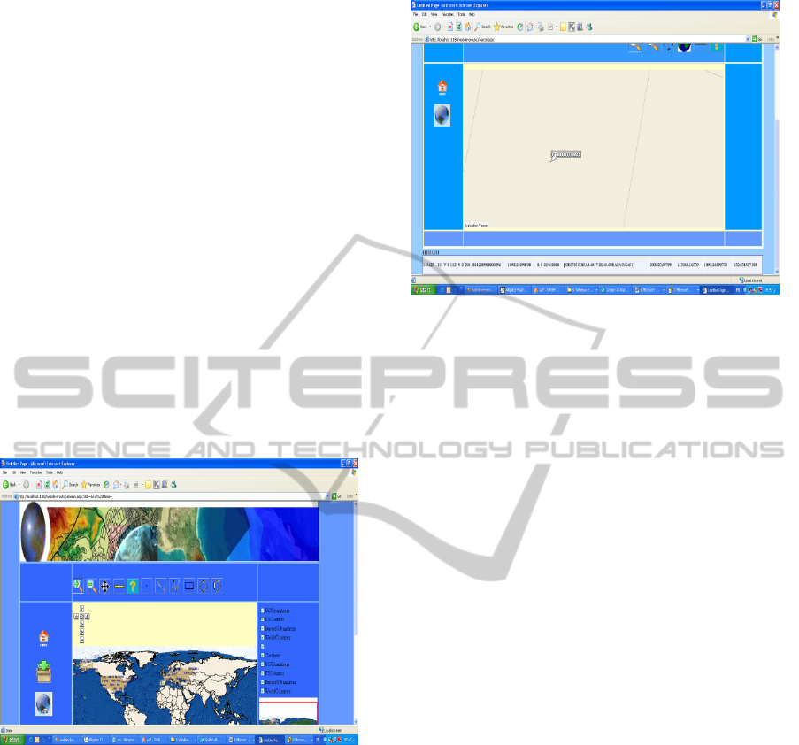
Figure 9: Publish World maps.
- Parcel Searching
Parcel searching for Amman area means that the
website has the ability to search for any parcel and
label it in Amman area. If we selected, for example,
the parcel number 011200900000296 and click find,
the system will zoom into the parcel target and
display information about this parcel; see Figure 10.
5 CONCLUSIONS
Web mapping and related technologies are
developed to enable the normal public to get into the
web mapping technologies with simple formation in
Figure 10: Parcel search in Amman.
cartography and programming skills. This paper
presents a system for web mapping based on
AspMap component. The map service is a WMS
compliant map server that uses a technically
competitive solution to serve a large-scale GIS
database on the Web. This successful development
shows us once more how easy to develop software
for local service. JOFAST is a web site (started
2009) to provide different services such as
navigation, tracking, parcel searching in the city of
Amman and Map creation services in a cost-
effective manner.
REFERENCES
Wikipedia, 2008b. Wikipedia page on "Web 2.0",
http://en.wikipedia.org/wiki/Web_2.0 (accessed 25
Apr 2008).
T. O'Reilly, 2005. An article on O'Reilly Media, Inc.
Website "What Is Web 2.0: design patterns and
business models for the next generation of software”,
http://www.oreilly.com (accessed 20 Apr 2008).
R. Van Wyngaarden, and N. Waters, N., “An unfinished
revolution: gaining perspective on the future of GIS”,
GeoWorld, 2007(9), pp. 22–25.
Wikipedia, 2008a. Wikipedia page on "Mashup (web
application hybrid)", http://en.wikipedia.org/wiki/
Mashup_%28web_application_hyb rid%29 (accessed
25 Apr 2008).
S. Li and J. Gong “Way of Providing Web Mapping/GIS
Services”, The International Archives of the
Photogrammetry, Remote Sensing and Spatial
Information Sciences. Vol. XXXVII. Part B4. Beijing
2008.
D. Merrill, “Mashups: The Newew Breed of Web App: An
Introduction to Mashups,” IBM Developer Works,
2006. http://www.ibm.com/developerworks/xml/li-
brary/xmashups.
THE DEVELOPMENT OF A WEB MAPPING SYSTEM AND ITS APPLICATION
27

P. Ramsey, “Mashing up the Enterprise,” Geospatial
Solutions, 2006. http://www.geospatialsolutions.com/
geospatialsolutions/author/authorDetail.jsp?id=34062
E. Pietroniro, and D. Fichter, “Map Mashups and the Rise
of Amateur Cartographers and Mapmakers,” ACMLA
Bulletin, 2007(127), pp. 26–30.
OSI - Open Source Initiative, http://www.opensource.
org/licenses/
X. Song, Y. Kono, and M. Shibayama, “The Development
of Web Mapping Application Using Open Source GIS
Solution”, Proceedinsg of the International
Symposium on Geoinformatics for Spatial
Infrastructure Development in Earth and Allied
Sciences, 2004.
P. Ramsey, “Open Source GIS Fights the Three-Horned
Monster,” GEO World, 2002. http://www.
geoplace.com/gw/2002/0208/0208gis.asp
V. Raghavan, P. Santitamont, S. Asumoto, and K. Honda,”
Implementing Web GIS Applications using Open
Source Software,” Proceedings of Map Asia 2002,
http://www.gisdevelopment.net/technology/gis
/techgi0062pf.htm
Menno-Jan Kraak, and Allan Brown,” Web Cartography –
Developments and Prospects,” Taylor & Francis, New
York, 2001.
[O. Al-Bayari, and B. Sadoun, “New centralized automatic
vehicle location communications software system
under GIS environment”, International Journal of
Communication System, Vol. 18, No. 8, pp. 833-846,
2005.
ICE-B 2011 - International Conference on e-Business
28
