
USING SR-TREE IN A CONTENT-BASED AND LOCATION-BASED
IMAGE RETRIEVAL SYSTEM
Hien Phuong Lai
1,2,3
, Nhu Van Nguyen
1,2,3
, Alain Boucher
2,3
and Jean-Marc Ogier
1
1
L3I, Universit´e de La Rochelle, 17042 La Rochelle cedex 1, France
2
Institut de la Francophonie pour l’Informatique, MSI, UMI 209, Hanoi, Vietnam
3
IRD, UMI 209, UMMISCO, IRD France Nord, Bondy, F-93143, France
Keywords:
Content-based image retrieval, Location-based information, Multidimensional indexing, SR-tree.
Abstract:
This paper presents an approach for combining content-based and location-based information in an image
retrieval system. With the performance for nearest neighbour queries in the area of multidimensional data
and for spatial data structuring, the SR-tree (Katayama and Satoh, 1997) structure is chosen for structuring
the images simultaneously in location space and visual content space. The proposed approach also uses the
SR-tree structure to organize various geographic objects of a Geographic Information System (GIS). We apply
then this approach to a decision-aid system in a situation of post-natural disaster in which images describe
different disasters and geographic objects are monuments registered in GIS data in the form of polygons. The
proposed system aims at finding emergencies in the city after a natural disaster and giving them an emergency
level. Some scenarios showing the interest of using content-based and location-based search in different ways
are also presented and tested in the developed system.
1 INTRODUCTION
This work aims to develop an information retrieval
model based simultaneously on visual content and
geographic location information of images. To our
knowledge, there are only few works combining
these two information types. The SnapToTell system
(Chevallet et al., 2007) tries to first use geographic
information for reducing the number of images that
have to be examined. Secondly, it uses content in-
formation for finding the most similar image in the
reduced image database. The MobiLog system (Ce-
merlang et al., 2006) sends the image with location
information to the SnapToTell server to get the infor-
mation about the scene visited by user; this informa-
tion will be then suggested to add in the user’s blog.
In our system, each image is represented by two de-
scriptors: a visual content descriptor and a geographic
location descriptor of image. Another type of infor-
mation useful for some application is geographic ob-
jects. Geographic objects can be a house, a building,
a street, etc. They are often registered in GIS system
in the form of point, multipoint, polyline or polygon.
The proposed approach uses the SR-tree structure
(Katayama and Satoh, 1997) which is based simulta-
neously on the structure of the R-tree (Guttman, 1984)
and the SS-tree (White and Jain, 1996) for structur-
ing simultaneously the visual content and the geo-
graphic location of images and for organizing the ge-
ographic objects. By incorporating bounding spheres
and bounding rectangles, we can reduce the overlap-
ping regions comparing with the case of R-tree and
SS-tree. This enhances the performance for nearest
neighbours queries in the area of multidimensional
data and for indexing spatial data objects that have
non-zero size (Guttman, 1984) of SS-tree and R-tree.
For implementing our approach, we develop a
decision-aid system in a situation of post-natural dis-
asters which is in the context of the IDEA project
1
.
The main idea is to exploit the images collected af-
ter a natural disaster by using a camera network lo-
cated throughout a city (surveillance cameras, cam-
eras mounted on patrolling robots, cameras installed
in buildings, aircrafts, inhabitant mobile phones, etc.)
to help local decision makers in organizing rescue.
1
Images of natural Disasters from robot Exploration in
Urban Area (IDEA), http://www.ifi.auf.org/IDEA/
491
Phuong Lai H., Van Nguyen N., Boucher A. and Ogier J. (2010).
USING SR-TREE IN A CONTENT-BASED AND LOCATION-BASED IMAGE RETRIEVAL SYSTEM.
In Proceedings of the International Conference on Computer Vision Theory and Applications, pages 491-494
DOI: 10.5220/0002831504910494
Copyright
c
SciTePress

2 CONTENT-BASED AND
LOCATION-BASED IMAGE
RETRIEVAL USING SR-TREES
We state the hypothesis that our image database is
partly annotated by image class. A small amount
of images have been manually annotated, while the
remaining is unknown. This is consistent with our
application (IDEA project), where initial images de-
scribe the knowledge of interest for the application,
while more images will be coming in real-time after-
ward. From this, we choose to organize the visual
content of images into several SR-trees correspond-
ing to different image class. The advantage of this ap-
proach is to use the visual content nearest neighbours
search with annotated images for each new incoming
non-annotated image for determining its class.
Our approach represents independently data in
both visual content and geographic spaces as follows:
(1) A SR-tree is built to represent feature vectors of
all annotated images. (2) All images are represented
into two spaces (total of 1+n SR-trees, where n is the
number of image classes) by a SR-tree organizing ge-
ographic descriptor (a point (x,y) representing longi-
tude and latitude) and many SR-trees organizing fea-
ture vectors (each SR-tree corresponding to one im-
age class). (3) All geographic objects are represented
into a single SR-tree; the region of each leaf is the in-
tersection of the bounding rectangle and the bounding
sphere covering all the points of an object.
We can realize some simple manipulations using
these SR-trees: (1) Nearest neighbours search can
be done for each non-annotated image using the SR-
tree of annotated images to determine the input image
type. (2) We can find in the SR-tree of geographic ob-
jects all objects that are geographically close within a
given radius from any image. (3) Using the SR-tree of
geographic location of images, we can find all images
that are geographically close to a geographic object
or to another image. (4) For finding images which are
most similar to an input image, the nearest neighbours
search is used in the SR-tree corresponding to the type
of the input image. More complex manipulations can
be realized based on these simple ones according to
different scenarios.
3 DECISION-AID SYSTEM IN A
SITUATION OF
POST-NATURAL DISASTERS
This section describes a decision-aid system in a situ-
ation of post-natural disasters for the IDEA project
implementing the approach proposed in section 2.
Each image in this system represents a disaster oc-
curring in the city. It contains geographic information
of GPS type (latitude and longitude). We character-
ize the visual content information using only the RGB
color histobins (vectors of 48 dimensions) of images
(more visual descriptors are planned to be added).
Geographic objects of interest are various monuments
of the four following types: houses, buildings, hospi-
tals, schools. This system aims to identify emergen-
cies in the city and to assign each of them an emer-
gency level according to the proximity between simi-
lar situations and to different monuments around each
disaster. For example, a fire occurring inside a hospi-
tal is more urgent than three consecutive residential
houses on fire.
Experimental Data Sources. We build our own
database using the “EarthquakeImage Archives”
2
and
several images representing emergency situations re-
trieved from the website Flickr
3
. All images are of
five different types of disasters (fire, wounded peo-
ple, damaged building, damaged road and flood), each
type contains between 300 and 350 image. Two
thirds of these images are annotated by its type. Re-
garding GIS data, we simulate them using the Col-
orados GIS database
4
and we add to this database in-
formation identifying four different monument types
(house, hospital, building and school).
In this system, we have six visual content SR-
trees (one for annotated-images and five for non-
annotated images corresponding to the above five dis-
aster types), one SR-tree for geographic location of
non-annotated images and one SR-tree for geographic
objects. Note that in the GIS database, each monu-
ment is represented by a polygon identifying its posi-
tion and its form. Each leaf of the geographic objects
SR-tree represents a monument. Therefore, if the ge-
ographic position of a disaster falls into the region of
a leaf identifying a hospital for example, we can say
that this disaster occurs inside the hospital.
Determination of Emergency Levels. Disaster type
identification of an image is based on the number
of different disaster types resulting of the k nearest
neighbours search applied into the visual content SR-
tree containing the annotated images. The problem
is to assign an emergency level for each disaster. It
is difficult to use visual content for this task, as we
2
http://geot.civil.metro-u.ac.jp/archives/eq/index.html,
Tokyo Metropolitan University.
3
http://www.flickr.com/, All images used in this work
are under the Creative Commons licence.
4
2007 TIGER/Line Shapefiles, http://www.census.gov/
geo/www/tiger/tgrshp2007/tgrshp2007.html
VISAPP 2010 - International Conference on Computer Vision Theory and Applications
492
have no information on the zooming factor or cam-
era distance for each image acquisition. We assume
that the emergency level is assigned only basing on
geographic information, which are the proximity be-
tween the similar disasters and the type of monuments
that are around each disaster. Other criteria like dis-
aster nature, influence of different disasters, etc, are
not considered in this paper. We determine r
1
, the ra-
dius denoting the geographic proximity between situ-
ations, and r
2
, the radius determining the proximity
between a situation and a monument. After a nat-
ural disaster, there may be a lot of images that are
sent to the server. It is useful to group similar sit-
uations according to their proximity in geographic
space and show to the user general information about
these groups. Two similar situations A and B will be
grouped together if there is a series of similar situa-
tions between A and B that each is close to another.
For determining the emergency level, we propose
the following approach. For each found disaster, we
assign an emergency level according to the disaster
type and to the monuments that are around this dis-
aster. Suppose that a disaster occurs at monument M
j
and we found a set M
1
,...,M
k
of monuments which are
near in a radius r
2
from the disaster, emergency level
L of the disaster is then computed as follows:
L = µ+ α
j
+
k
∑
i=1
β
i
(1)
where: (1) µ is the emergency level corresponding to
each disaster type. In this paper, we use µ = 1 for
all different disaster types. For giving more realistic
values, we are planning to consult rescue experts in
the future. (2) α
j
is an emergencyfactor added know-
ing that a disaster occurs at the monument M
j
. (3) β
i
is an emergency factor added knowing that a disas-
ter occurs at a position near to the monument M
i
.The
value of α and β depend on the type of monument.
Using the SR-tree of external descriptor of all current
images, we can group the disasters in different prox-
imity groups as defined above by finding in the geo-
graphic SR-tree all images which are close together
in a radius r
1
and then assign to each group an emer-
gency level that is equal to the sum of the emergency
levels of all disasters belonging to this group.
4 RESULTS
We describe in this section some scenarios which
combine content-based search and location-based
search in different orders and test them in our
decision-aid system in a situation of post-natural
disaster. The quantitative evaluation is planned to be
done in a further collaboration with rescue experts.
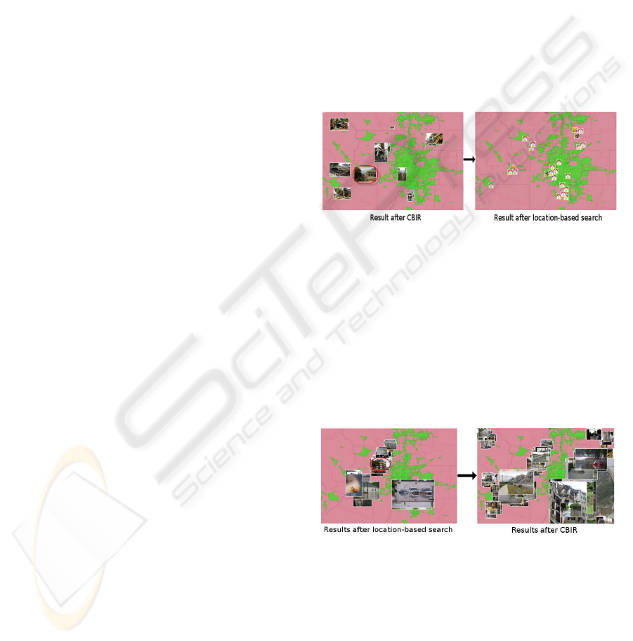
Scenario 1: CBIR → Location-based Search. Fig-
ure 1 presents an example of this scenario type which
aims to find all monuments which can be affected (ge-
ographically close) by one of the disasters which are
similar to an input disaster (query image, eg. a fire).
After determining the type of disaster (image class)
using the nearest neighbour search in the SR-tree con-
taining the annotated images, the system performs a
CBIR search in the SR-tree corresponding to the type
of the query image to find similar images and then
performs a location-based search for each retrieved
image from the previous step in the SR-tree of monu-
ments.
Figure 1: Scenario 1: CBIR → location-based search.
Scenario 2: location-based search → CBIR. This
scenario is opposite to the previous scenario in using
first location-based search in geographic location SR-
tree for finding all images which are geographically
close to a query image or an input geographic object
and secondly using CBIR for finding all images which
are similar to each retrieved image from the location-
based search. Figure 2 shows an example of results
using this scenario.
Figure 2: Scenario 2: location-based search → CBIR.
Scenario 3: CBIR and Location-based Search
Simultaneously. We can perform CBIR and location-
based search together and select within both set of
retrieved results. A scenario using together CBIR and
location-based search is to determine the emergency
level of an image. CBIR is used in the SR-tree of
annotated images for determining the disaster type
of the input image and the location-based search
is used both in the geographic location SR-tree
USING SR-TREE IN A CONTENT-BASED AND LOCATION-BASED IMAGE RETRIEVAL SYSTEM
493
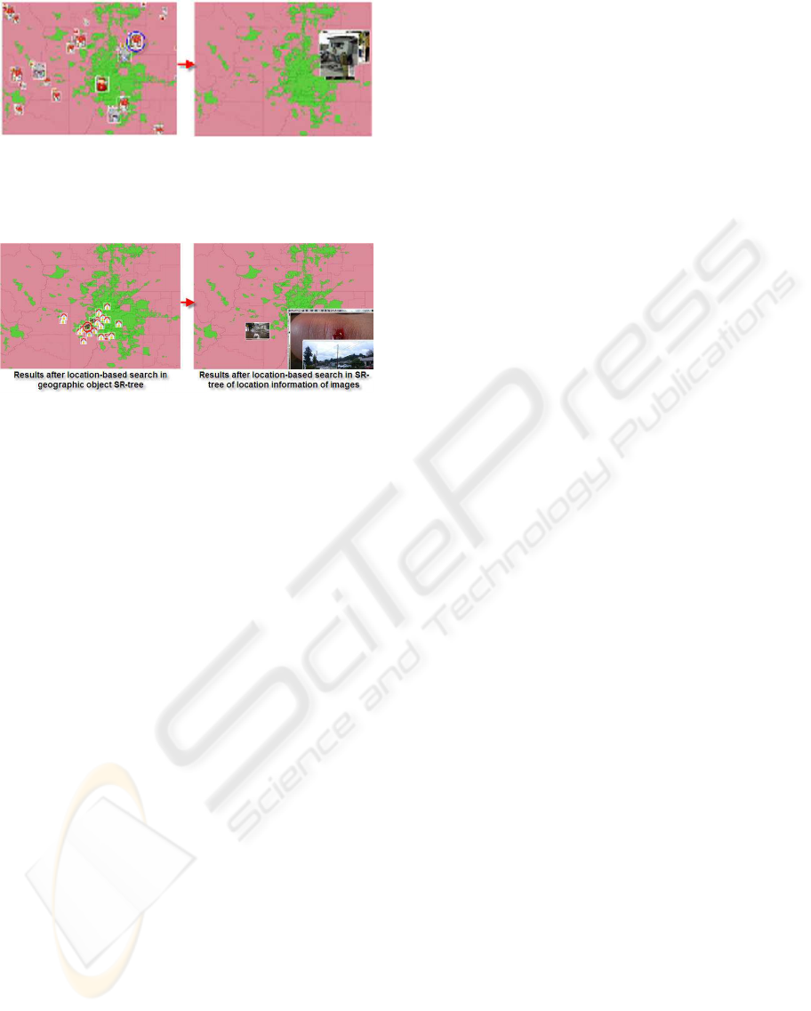
Figure 3: Scenario 3 - The system gives an overview of
the distribution of disasters and also their emergency level
corresponding to the symbol size. User can choose to view
all disaster images within a proximity group.
Figure 4: Scenario 4 - This example uses two successive
location-based searches first in the SR-tree of geographic
monuments and secondly in geographic location SR-tree of
images.
of images and in the geographic object SR-tree
for finding disasters and monuments of interest
near the input query image. All this information
is used for determining the emergency level cor-
responding with the input query image using the
method described in section 3. The system gives an
overview of all disasters in the city so that user can
observe the distribution of disasters and also their
emergency level corresponding to the symbol size in
order to make rescue decisions quickly (see Figure 3).
Scenario 4: Many Location-based Searches. We
can perform location-based search both in the geo-
graphic location SR-tree of images and in the SR-tree
of geographic objects in different orders for retriev-
ing different information. Figure 4 presents results for
finding all disasters that can affect one of monuments
which are around another monument.
5 CONCLUSIONS
The presented approach, using the SR-tree structure
for representing images into two different spaces (vi-
sual content and location information) and for repre-
senting geographic objects, allows merging content-
based image retrieval and location-based search in
different ways according to requirements of differ-
ent applications. Different scenarios are presented
here for an application of decision-aid for rescue man-
agement, but it can be applied to different applica-
tions. More specifically, by applying our approach to
the decision-aid system in a situation of post-natural
disaster, we provided for the user an overview of
the disasters in an urban zone (position, emergency
level of each disaster). Thus, the user can coordinate
appropriately rescue teams. Moreover, using multi-
ple SR-trees for representing information in different
ways, it allows the system to manipulate very differ-
ent types of information (visual content and location-
based) and to provide the appropriate result by search-
ing only in the right SR-trees.
But there are some limitations that will need to
be improved as further work. Concerning the gener-
icity of the system, location-based information could
be found within the image and not necessarily given
externally. Text detection and recognition could pro-
vide addresses or location names within the images.
Recognition of known buildings or monuments from
the images could also give clues about the location
of the images. Concerning the specific application
for natural disasters, we are planning to integrate ex-
perts and interactive experiments for determining all
parameters in our system.
ACKNOWLEDGEMENTS
This project is supported in part by the ITC-Asia
IDEA project from the French Ministry of Foreign
Affairs (MAE), the DRI INRIA and the DRI CNRS.
The authors also thank the Region Poitou-Charentes
(France) for its support in this research.
REFERENCES
Cemerlang, P., Lim, J. H., You, Y., Zhang, J., and Chevallet,
J. P. (2006). Towards automatic mobile blogging. In
Proceeding of IEEE ICME 2006, pages 2033–3036.
Chevallet, J. P., Lim, J. H., and Leong, M. K. (2007). Ob-
ject identification and retrieval from efficient image
matching. snap2tell with the stoic dataset. Inf. Pro-
cess. Manage., 43(2):515–530.
Guttman, A. (1984). R-trees: A dynamic index structure
for spatial searching. In Proceeding of the 1984 ACM
SIGMOD, ICMD, pages 47–57.
Katayama, N. and Satoh, S. (1997). The sr-tree: An in-
dex structure for high-dimensional nearest neighbor
queries. In Proceedings of the 1997 ACM SIGMOD,
ICMD, pages 369–380.
White, D. A. and Jain, R. (1996). Similarity indexing with
the ss-tree. In Proceeding of the 12th ICDE, pages
516–532.
VISAPP 2010 - International Conference on Computer Vision Theory and Applications
494
