
ONTOLOGY-BASED MODEL ANNOTATION OF
HETEROGENEOUS GEOLOGICAL REPRESENTATIONS
1
Laura Silveira Mastella,
2
Yamine Ait-Ameur,
1
Michel Perrin and
3
Jean-François Rainaud
1
Ecole des Mines de Paris, 60, boulevard Saint-Michel, 75272, Paris, France
2
LISI - ENSMA and University of Poitiers, BP 40109, 86961 Futuroscope Cedex, France
3
Institut Français du Pétrole, Direction Technologie, Informatique et Mathématique Appliquées
1-4 Avenue de Bois-Préau, 92852 Rueil-Malmaison Cedex, France
Keywords: Model annotation, Ontology, Petroleum reservoir modelling.
Abstract: In this work we study the process of petroleum reservoir modelling as a case of study for applying ontology-
based integration techniques and model annotation. A complete reservoir model gathers information
resulting from several interpretations using heterogeneous representations. We propose that the different
geological interpretations and representations should be annotated, for being integrated. We describe an
approach based on local ontologies for the specific domains, whose concepts are mapped to a shared global
ontology which contains the basic terms used in reservoir modelling.
1 INTRODUCTION
In this work we will study the process of petroleum
reservoir modelling as domain for applying
ontology-based annotation techniques. The models
used for petroleum exploration (earth models)
correspond to final representations of the geological
objects resulted from successive steps of
interpretation operated by professionals from
various earth science domains.
Considering this Reservoir Modelling Workflow,
one difficulty for semantic integration is the
heterogeneity of representation, since one same
geological item is likely to be pictured in many
different ways within the different geomodelling
applications.
To meet this issue, we will propose here an
approach based on semantic annotation of models.
We define local ontologies for annotating the
domain specific models and a global shared
ontology for gathering the vocabulary common to
all these domains. We will focus on a branch of
reservoir modelling activities which will be detailed
in the next section.
2 RESERVOIR MODELLING
WORKFLOW: A CASE STUDY
As a case study, we will consider here the part of
workflow going from the Seismic Interpretation to
the Structural Model building, starting from a real
field data set and choosing real geo-modelling
applications.
Seismic Interpretation: considering the seismic
image of
Figure 1(a), it can be interpreted by
identifying the portions of horizontal traces as
reflectors, or by considering that aligned vertical
traces correspond to interruptions. So, on
Figure
1
(b), the user identify several reflectors (r1, r2, r3)
and two main interruptions (int1 and int2). The user
then saves these seismic items as “cloud of points”
in data files, that will be the input of the structural
model application.
Structural Modelling: the files corresponding to
interpreted seismic will be imported into a structural
modelling application. Geologists will then apply
definite geological rules to assemble them. For
example, in the Figure 1(c) the faults f1 and f2,
interrupt the horizon h1. The structural model is
saved in specific structural modelling formats.
290
Silveira Mastella L., Ait-Ameur Y., Perrin M. and Rainaud J. (2008).
ONTOLOGY-BASED MODEL ANNOTATION OF HETEROGENEOUS GEOLOGICAL REPRESENTATIONS.
In Proceedings of the Fourth International Conference on Web Information Systems and Technologies, pages 290-293
DOI: 10.5220/0001520302900293
Copyright
c
SciTePress
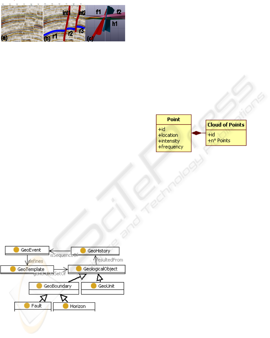
Figure 1: (a) Raw seismic image, (b) Interpreted seismic
and (c) Structural model.
The practical issue that has to be solved is how
the concepts of the “Seismic domain” can be put in
correspondence with those of the “Structural
modelling domain”. This is not possible at present
since we cannot recover the relation between objects
identified in different phases of the process.
2.1 Geological Objects
Geological objects are identified in the beginning of
the workflow and evolve within the different earth
models. Geological objects appear as the red thread
to which all interpretations and representations in
the workflow should be attached and that can thus
guide most of the modelling process. For this
reason, we believe that the entities considered in the
various representations should all be characterized
as actual geological objects having a unique
identification. The geological objects that we will
use in this case of study are represented in a geology
ontology formerly presented in (Perrin, Zhu,
Rainaud, & Schneider, 2005) and (Mastella, Perrin,
Abel, Rainaud, & Touari, 2007). An extract of the
whole ontology is shown in
Figure 2. It represents
the basic vocabulary shared by all earth science
domains.
Figure 2: Extract of Basic Geology ontology
1
.
Another problem is that current software systems
are not able to take into account the fact that the
successive categories of data have been interpreted
as corresponding to the same geological object.
To address this issue, we believe that each of
these geological objects should also be linked to its
specific representation along the modelling chain.
2.2 Geological Applications’
Metamodels
Each task of the workflow uses a different earth
modelling application, which represent the
geological objects in a different way. So as to
identify the objects within applications, we need to
semantic annotate their metamodel, which
represents the primitives used by the application to
represent a geological object. For example, the
metamodel of a seismic interpretation analysis tool
is as shown in
Figure 3.
Figure 3: Metamodel for the seismic interpretation
2
.
This metamodel stipulates that an object has
different seismic associated properties (frequency,
etc), which will be useful to identify the concept in
the ontology later on. We will describe in the next
section the approach that we propose.
3 ONTOLOGIES FOR MODEL
ANNOTATION
Ontology-based annotation of resources allows to
assign explicit meanings to objects and features
interpreted by an observer. In this work, we intend
to use ontologies to annotate domain specific
models. We describe here an annotation architecture
that helps users to make explicit their interpretation
about the geological models. Unlike the common
methods, the annotation architecture in this work are
not automated; it is expected that human users will
provide the detailed annotations of the models,
subject to the contents and constraints of the
ontology. The goal of the completed annotations is
to offer a knowledge base (knowledge = geological
models' data + annotations) which stores the
geological interpretation.
ONTOLOGY-BASED MODEL ANNOTATION OF HETEROGENEOUS GEOLOGICAL REPRESENTATIONS
291
3.1 Model Annotation Architecture
We are choosing ontologies because it is a
consolidated approach to solve the problem of
integration of heterogeneous information (Noy,
2004; Uschold & Gruninger, 2005). The work of
(Lin, Strasunskas, Hakkarainen, Krogstie, &
Solvberg, 2006) describes an approach of semantic
annotation of process templates, for better reuse of
this process in the business workflow using a
general ontology.
We intend to set up the hybrid approach of
ontologies (general + local) to the problem of the
reservoir modelling workflow. Indeed, we have
different specific knowledge domains and one pivot
field that is shared by the others. For this reason, we
propose an annotation methodology resting on (1)
local ontologies (LO) which represent the concepts
of the local domains of expertise or activities, such
as Seismic (an extract represented in UML-like class
diagram is shown in Figure 4), Structural Geology,
that are required for annotating each specific
representation; (2) a global ontology (GO), the
Basic Geology Ontology (section 2.1), which links
concepts used in the local ontologies; (3) application
metamodels, for specifying how computing
applications represent geological objects.
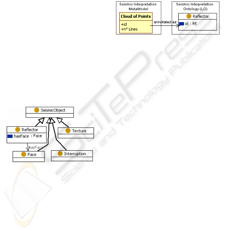
Figure 4: Extract of Seismic Interpretation LO
1
.
The objective is not to integrate the concepts of
the local ontologies inside the global ontology, but
to establish subsumption links (isA and isCaseOf)
between the local concepts and the shared concepts.
Accordingly, we require to each LO concept
instance to be an instance of at least one subsuming
concept in the GO. We will use LO concepts to
annotate the specific applications metamodels by (i)
creating an interpretation link between an
ontological concept and a metamodel entity and (ii)
assigning a unique identifier to the metamodel entity
that is interpreted. The objective is to allow the
ontological manipulation of the application aspects.
This implies that each instance of the LO can be
referred and accessed from the GO level without any
specific knowledge nor expertise of the LO level.
In the moment when the geologist performs an
interpretation, he assigns a unique identifier to the
instance of the local ontology, which is the same of
the entity in the modeling tool. Figure 5 shows how
to annotate an entity of the seismic metamodel
(Cloud of Points) with a concept of the seismic local
ontology (Reflector).
Figure 5: Seismic interpretation: Cloud of Points
annotated as Reflector.
We have defined an approach on metamodels
and ontological concepts. Next section shows a
complete case study involving instances of the
concepts described above.
4 APPLICATION TO THE CASE
STUDY
Let us consider the two tasks shown in section 2: the
Seismic Interpretation and the Structural Model. We
will see in Figure 6 the architecture that represents
how to annotate the files that represent geological
objects.
The objects recognized in the seismic
interpretation are the reflectors and interruptions.
When this interpretation is saved in the specific
computing application, they are saved as clouds of
points. In order to annotate the seismic files, we
create a link from the metamodel entities to the
Seismic Local Ontology (Figure 6 (a)).
In a second phase, the reflectors are interpreted
by the geologist as portions of horizons; and the
aligned interruptions are interpreted as faults. In this
case, the user is using a Basic Geology vocabulary.
So, the link is made between the concepts of the
Seismic Local Ontology to the concepts of the
Geology Global Ontology (
Figure 6 (b)). This
represents the basic subsumption link between the
concepts of the two ontologies: Reflector is_a
Horizon, Interruption is_a Fault.
When the user passes to the structural modelling
phase, his/her interpretation consists in identifying
structural objects from the image. The geologist may
identify several portions of horizons that are likely
WEBIST 2008 - International Conference on Web Information Systems and Technologies
292
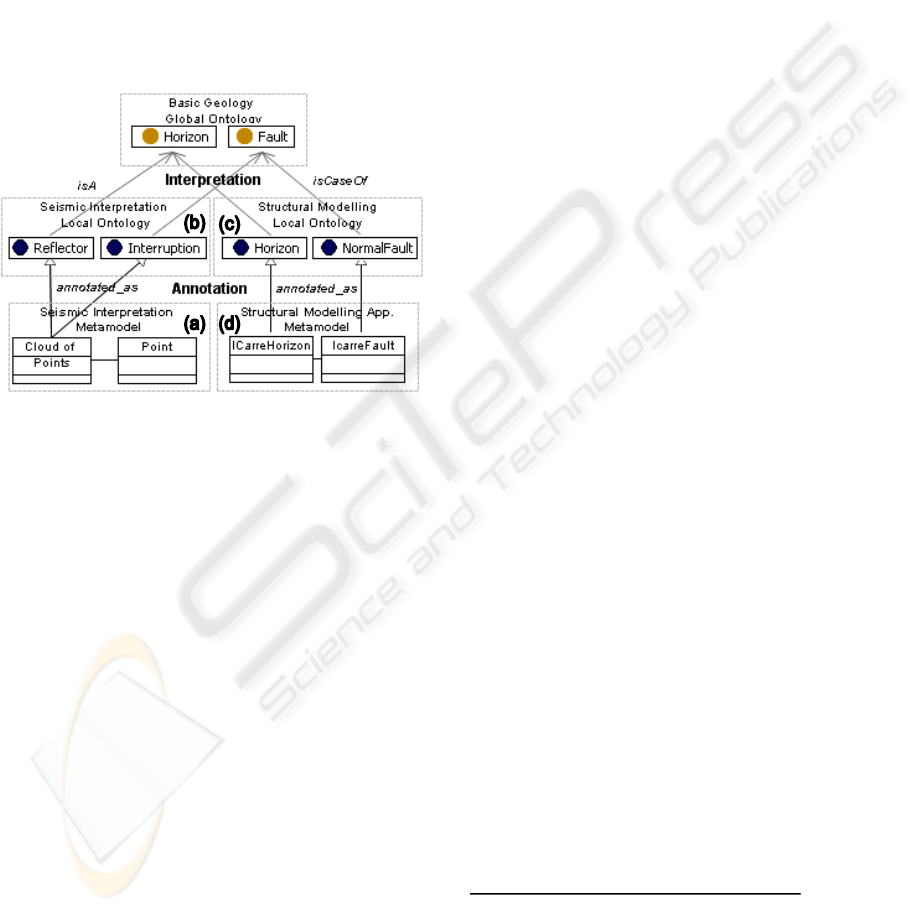
to be parts of one same structural horizon. And
he/she can specify the structural category of the fault
(normal, reverse), by observing the way it affects the
structure. This illustrates the subsumption link
between the concepts of the GO and the concepts of
Structural Geology LO: NormalFault is_a Fault
(
Figure 6 (c)).
Finally, when the user stores the structural
model, the objects are saved in binary files that
represent a specific structural interpretation
metamodel (such as ICarre metamodel
3
), whose
entities are annotated with the concepts of the
Structural modelling LO. (Figure 6 (d).
Figure 6: Links between GO, LO and Metamodels.
Setting up this approach, we are able to answer
to queries that refer to different domains. Such a
query would be, for example, by which seismic
reflectors is formed the structural horizon H1? An
structural horizon is represented as an
ICarreHorizon (d), which is annotated as
StructuralHorizon (c), which is subsumed by the
concept Horizon in the GO. All those instances have
the same ID. It is then easy to retrieve the instances
of Reflector in the Seismic LO that are subsumed by
the GO Horizon and that are used to annotate the
looked-for “cloud of points” files.
5 CONCLUSIONS
We have presented here an approach based on
ontologies to annotate specific domain conceptual
models. The application domain is the workflow of
oil reservoir modelling, which is a multi-
representation multi-interpretation domain. In this
process, an interpretation can be considered as
putting in correspondence concepts belonging to
different specialized domains. So, our architecture
proposes to create semantic annotations from the
specific metamodels to the local ontologies. Then,
the local ontologies concepts are subsumed by the
global ontology concepts, which is the pivot of the
modelling process.
Creating correspondences between the models is
likely to enable us to answer queries that cannot be
addressed at present, because we cannot recover the
relation between objects identified in different
phases of the process.
The next steps in this work will be to automate
most complex mapping rules, which will represent
inferences that can be made within specific domains.
Moreover, we expect to scale up the proposed
approach to deal with large file size interpretations.
We plan to use persistent models with ontology
based databases.
REFERENCES
Lin, Y., Strasunskas, D., Hakkarainen, S., Krogstie, J., &
Solvberg, A. (2006). Semantic Annotation Framework
to Manage Semantic Heterogeneity of Process
Models. In S. B. Heidelberg (Ed.), Advanced
Information Systems Engineering (Vol. 4001/2006,
pp. 433-446): Springer.
Mastella, L., Perrin, M., Abel, M., Rainaud, J.-F., &
Touari, W. (2007). Knowledge Management for
Shared Earth Modelling. Paper presented at the EAGE
Conference & Exhibition, London.
Noy, N. F. (2004, December 2004). Semantic Integration:
A Survey Of Ontology-Based Approaches. SIGMOD
Record, Special Issue on Semantic Integration, 33.
Perrin, M., Zhu, B., Rainaud, J.-F., & Schneider, S.
(2005). Knowledge-driven applications for geological
modeling. Journal of Petroleum Science and
Engineering, 47(1-2), 89-104.
Uschold, M., & Gruninger, M. (2005). Architectures for
Semantic Integration. Paper presented at the Dagstuhl
Seminar Proceedings: Semantic Interoperability and
Integration, Dagstuhl, Germany.
1
. UML-like class diagram from TopBraid Composer tool
(http://topbraidcomposer.com).
2
. UML class diagram.
3
. OpenFlow ICarre proprietary modelling application of French
Institute of Petroleum (http://www.ifp.fr).
ONTOLOGY-BASED MODEL ANNOTATION OF HETEROGENEOUS GEOLOGICAL REPRESENTATIONS
293
