
INTEGRATION OF A FUZZY SYSTEM AND AN INFORMATION
SYSTEM FOR THE TERRITORIAL UNITS RANKING
Miroslav Hudec
Institute of Informatics and Statistics, Dubravska cesta 3, Bratislava, Slovakia
Mirko Vujošević
Faculty of Organizational Sciences, University in Beograd, Beograd, Serbia
Keywords: Fuzzy systems, ranking, territorial unit, information system.
Abstract: For ranking and classification of the territorial units, up-to-date and precise data as well as ranking tool are
needed. The advantage of fuzzy systems (FS) in these tasks is in definition of a problem by linguistic terms.
The disadvantage is in universality and complexity of the fuzzy systems for end users. This disadvantage
comes from usage of FS to solve a wide area of different tasks. The advantages and the disadvantages, as
well as constraints of FS are analyzed. The aim of this paper is to show the information systems about
territorial units of the Slovak Republic and possibilities of integration fuzzy system for ranking territorial
units with these information systems. This approach enables creation of the model, importing the input data,
processing of the rules and presentation of the solution in a usable and understandable form. In this case
solution is presented on a thematic map too.
1 INTRODUCTION
The elements of significant importance for the
ranking and classification of the territorial units are
adequate number of indicators, their precise and up-
to-date collection and qualitative usage of data for
ranking. The support for ranking can be attained
only with the design and implementation of an
accurate information system and an adequate system
for the territorial units ranking.
The aim of the research presented in this paper is
to illustrate how this amount of data and FS can be
used in classification and ranking problems. The
classification and ranking of the territorial units is of
significant importance for the regional development
planning. The paper aims to present abilities of FS
as an alternative approach to classical statistical
methods for the classification and ranking tasks.
The collection and storage of data, even if exist a
prefect information system for collect all possible
indicators for all territorial levels, is an excellent
basis but without reference to usage them in research
and decision process is unuseful.
This paper briefly describes information systems
for territorial units in the Slovak Republic. This
paper also discusses some advantages and
disadvantages of the fuzzy approach for the
territorial units ranking and suggests the integrated
FS (IFS) with statistical information systems.
2 INFORMATION SYSTEMS FOR
TERITORIAL UNITS
The MOŠ/MIS (Urban and municipality statistics/
Urban information system) is officially used in the
Statistical Office of the Slovak Republic. The
INFOREG (Information system for support of the
regional development) is in the phase of pilot
application. The data from these two systems can be
used for ranking of territorial units.
The MOŠ/MIS is developed according to the
Nomenclature of Units for Territorial Statistics
(NUTS) which defines hierarchical and geographical
dividing of territory in a country. NUTS
classification is important in the harmonization and
comparing of regional data between countries that
have implemented NUTS. All territorial units at the
first three levels of NUTS have unique code in
374
Hudec M. and Vujoševi
´
c M. (2007).
INTEGRATION OF A FUZZY SYSTEM AND AN INFORMATION SYSTEM FOR THE TERRITORIAL UNITS RANKING.
In Proceedings of the Ninth International Conference on Enterprise Information Systems - AIDSS, pages 374-377
DOI: 10.5220/0002355103740377
Copyright
c
SciTePress
whole EU. The basic territorial units for the
MOŠ/MIS are urbans and municipalities on level 5
of NUTS. This system covers collection of
indicators for this level only. This system turned out
to be successful in the municipality statistical area.
The INFOREG platform facilitates data
collection, storage, management of data and their
presentation for all NUTS levels. The structure of
the INFOREG database consists of these
dimensions: indicator, territorial unit and period.
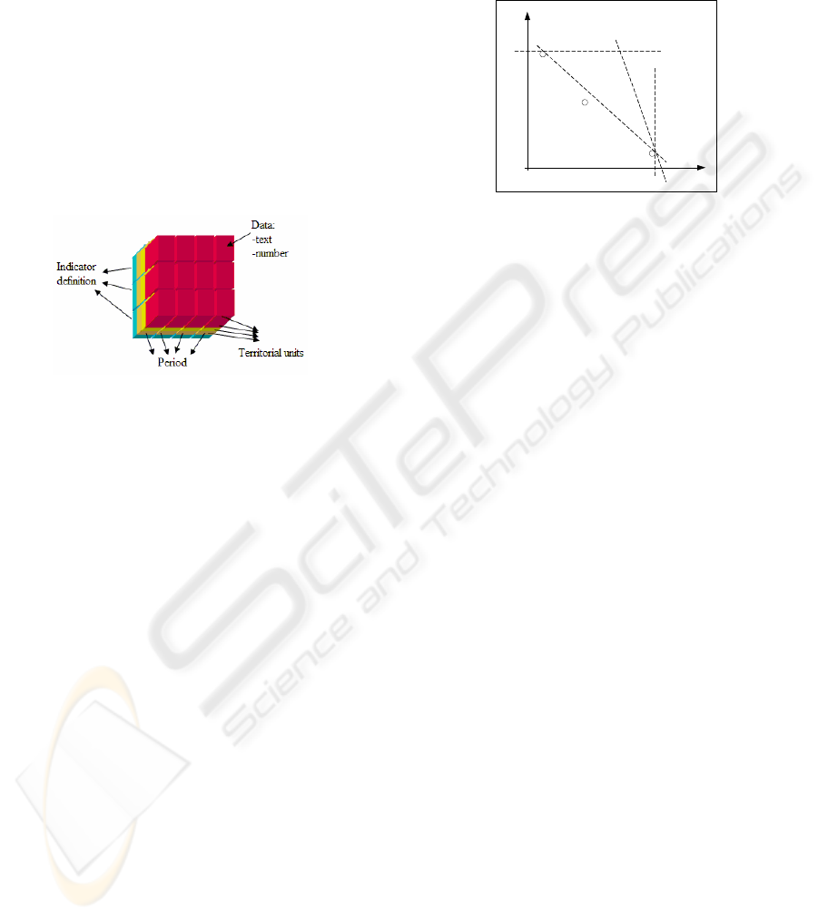
The structure of database is presented in three-
dimensional cube in figure 1 (Priehradníková,
Benčič and Hudec, 2005). In the intersection of
dimensions is the indicator value. For example: 70
inhabitants/km
2
is density of population (source
Statistical Office) for Bystrica region for 2003 year.
Figure 1: Structure of three-dimensional cube.
The territorial unit dimension is defined by
NUTS classification. The period presents all
possible periods of collecting indicator values. The
dimension of indicator has the most complex
requirements. The set of indicators is vast and there
is the expectation that new indicators might be
added according to requirements for information.
The main qualitative impacts of INFOREG are:
• effective support for research and
development, strategy building, realization
of the regional policy and investments during
their decision making processes;
• development of sophisticated indicators
system, which reflects the situation in
municipalities and regions.
The next chapters present the FS use in ranking
and classification tasks and the development of the
integrated FS with the information systems
mentioned above.
3 FUZZY APPROACH
The process of finding the best solution or ranking
of the objects could be done using different methods.
Classical methods usually use ponders to set
importance for each attribute. Figure 2 shows
situation when a system based on logic (an expert
system) allows to obtain expected solution (point C)
whereas by the method based on ponders is not
possible to reach this solution. Depending of the
changes in coefficient values for attributes X
1
and X
2
the object function f reaches solutions A or B.
Figure 2: Finding of the best solution.
If is classical expert system widened with the
fuzzy logic, fuzzy expert system or just fuzzy system
based on the fuzzy “if-then” rules is attained. FS
includes fuzzy sets and fuzzy logic into inference
process and that gives significant advantages beyond
the constraints of classical logic in many different
tasks. The fuzzy logic possesses the ability to mimic
the human mind to effectively calculate modes of
reasoning that are approximate.
3.1 Advantages and Disadvantages
Despite the fact of important results in practical
applications, fuzzy approach is not a total
generalization of the Boolean algebra (BA) for the
multivalued logic (Radojević, 2005). It means that
the fuzzy approach is not capable to fulfill some of
the axioms or theorems of BA. For example the sum
of atomic functions
), , , (
____
babababa ∧∧∧∧
is not
always equal to 1 and the excluded middle
)(
_
aa ∨
and the contradiction
)(
_
aa ∧
laws are not satisfied
always. According to these, it can be considered that
fuzzy algebra: <[0,1], T, S, N> where T denotes T-
norm, S is S-norm and N is complement, is not BA.
It is possible to avoid these disadvantages and to
exploit good properties of fuzzy approach by
analysis of each task to keep staying in BA frame.
In case of using
) ( ba ∧
rule, the min T-norm
gives good output solution. Lukasiewicz T-norm
gives more restricted output when membership
degrees of a and b satisfy relation (a+b)<1, because
the consequence of rule is always equal to zero. The
advantage of Lukasiewicz T-norm is in the event of
using complement in rules:
)(
_
ba ∧
and when some
of controlling rules, like contradiction
)(
_
aa ∧
are
used. In these cases Lukasiewicz T-norm satisfy
Boolean axiom whereas min T-norm does not satisfy
it. In case of softly ranking of municipalities by min
X
X
1
2
f
f
f
A
B
C
INTEGRATION OF A FUZZY SYSTEM AND AN INFORMATION SYSTEM FOR THE TERRITORIAL UNITS
RANKING
375

T-norm all municipalities that have sum of all
membership functions in rule less than 1 can be
ranked. If FS uses for example aggregation
) ( ba∧
and if min T-norm is used, what is usual case in real
applications then FS is consistent with the BA.
If restrictions mentioned above are satisfied, the
FS can be suscessfuly used in ranking and
classification tasks because they:
• enables the creation of logical inference
system based on human mind including
uncertainities in membership degrees to the
appropriate fuzzy sets.
• supports the inference process based on “IF-
THEN” rules.
• enables accessible and understantable
knowledge base for users.
The Sugeno model of fuzzy inference system
(FIS) from the MatLab software is implemented for
municipalities ranking according to needs for the
road maintenance in winter. The data from the
MOŠ/MIS were used. (Hudec and Vujošević, 2005).
The disadvantage is in the complexity of using
FIS in software products (MatLab…) and non-
existence of integration between FIS and databases
for domain experts. The decision makers
requirement for FIS is its simplicity for use to
impose the obvious advantages of the FS. The FIS
usually does not satisfy this criteria. The powerful
software for FIS is produced for wide area of tasks
and is complicated for users. In order to solve a task,
the decision maker needs the assistance from an
information system expert for preparing the input
data from database into proper format for FIS and
for presenting results in useful form. The decision
maker also needs an operational research expert to
set appropriate functions for aggregation,
implication, accumulation and defuzzification in
FIS. The FIS tools usualy offer variety of functions
and fuzzy model could become unreliable if
unparopriate functions are chosen.
3.2 Integrated Fuzzy System
The Integrated fuzzy system (IFS) was developed to
avoid disadvantages mentioned above. Figure 3
shows the IFS for territorial units ranking. The
interface to database enables the selection of
territorial units and indicators which are important
for ranking task. Selected territorial units and values
of chosen indicators are converted into appropriate
matrix form for the FIS.
In suggested IFS the zero ordered Sugeno model
of fuzzy inference is used. Unconditional fuzzy rules
are not of interest in territorial ranking tasks so to
use Mamdani model is not necessary. FIS can be
expanded in future by Mamdani model to use non
singleton fuzzy sets in the model output part.
Ordinary fuzzy sets as triangular, trapezoidal or
bell shaped type are used in the IFS. These fuzzy
sets are not complicated and in this case keep
enough information for description of ambiguity
from the decision maker point of view. The next step
is the knowledge representation using inference
rules that connect the input with the output. The
rules are of the “if-then” form. Although
determining of these rules is intuitive, it is very
important to include all interesting cases in these
rules. Antecedent part of the rule is connected by
and, or or not operators. The fuzzy model for a
ranking task is after these two steps defined. The
next step is the processing of the rules for selected
territorial units. Processing of the rules depends on
selected functions for aggregation, implication and
accumulation. Min T-norm is used for “and“
aggregation. In order to support selection of proper
T-norm for fuzzy model defined by user, integrated
system would have to select appropriate T-norm
according to selected type of fuzzy rules. For the
implication, the Mamadani implication is used.
In order to solve a ranking problem within a
knowledge-based fuzzy system it is necessary to
provide results in a usable and understandable form.
The result of ranking in a vector form is connected
with code list of territorial units and exported into
xls format for additional spreadsheet calculations. In
territorial units ranking, providing the result in a
thematic map is very useful too. For this purpose the
result form the FIS is adapted for presenting results
in a map. The rank for every territorial unit, obtained
by the FIS and determined by territorial unit primary
key, is connected across this key to the identification
of the particular polynomial area of the vector map.
The map shows territorial survey of municipality
ranking. These two modes for presenting of the
results are shown in the right part of Figure 3.
The FIS is under development in the VB.NET as
well as other parts of IFS: the database interface and
the export solutions to the spreadsheet calculations
format and maps. The knowledge and experiences
obtained from ranking of municipalities by existing
FIS in the MatLab was used for IFS development.
More comparison to the other systems for
estimation and ranking (e.g. DEA, or OLAP) will be
done once the IFS is implemented. This comparison
is interested in the obtained result as well as in
ICEIS 2007 - International Conference on Enterprise Information Systems
376
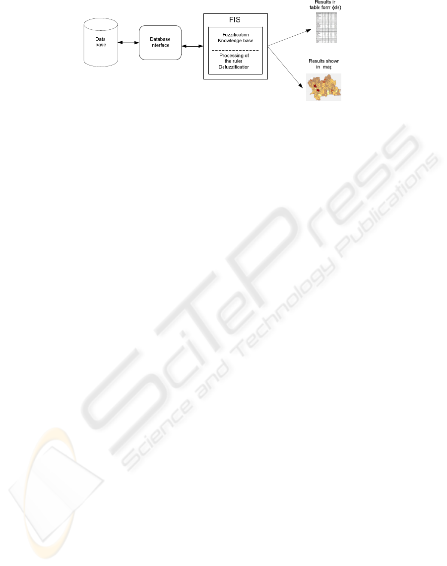
Figure 3: Integrated fuzzy system.
simplicity of use for end users. The second
comparison means level of satisfaction of the system
functionality for easiest creation of a model and for
solving particular ranking task from decision maker
point of view.
The IFS can be used in ranking tasks for
territorial units in other countries too. This
possibility is at this moment only theoretical. There
are some more conditions that have to be satisfied.
Hierarchical structures of territorial units in
databases need to be compatible with the NUTS and
adequate maps for territorial units need to be
available for use.
4 CONCLUSIONS
The support for the ranking can be attained only
with the design and implementation of an adequate
information system and an adequate system for
territorial units ranking.
The object of this research was to improve the
support for decision makers during their work with
the statistical data. In this area of work expressions
like: low or high rate of unemployment, low
pollution, etc. are frequently used. It was needed to
adapt and include these expressions into inference
process. Upon the obtained results from previous
research in fuzzy ranking the IFS is suggested as a
support tool for these decision makers.
It was proven in the previous research that the FS
may be successfully used for municipalities ranking
tasks. The results were reasonable and expected
(Hudec and Vujošević, 2005). Disadvantages of the
FS were found too. The aim of this paper was to
avoid some of disadvantages and to exploit
advantages mentioned above. Meanwhile, the
INFOREG was developed. The possibility of the FS
integration with the INFOREG enables more
flexible using of the FS in territorial ranking tasks.
Briefly, the use of the FS has given satisfactory
solutions and the IFS provides better working
environment.
Decision makers and domain experts obtain
useful tool for their work. This tool exempts them
from the help of information and fuzzy systems
experts during preparing of a fuzzy model and the
process solution.
REFERENCES
Benčič A., Hudec M., 2002. MOŠ/MIS–Urban and
municipal statistics project and information system of
the Slovak Republic. SYM-OP-IS’02. Vuletic Print.
Belgrade.
Cox E., 2005. Fuzzy modeling and genetic algorithms for
data mininig and exploration, Morgan Kaufmann
Publishers. San Francisco.
Ioannidis C., Hazichristos T. (2000). A municipality
selection proposal for the expansion of the Hellenic
cadastre using fuzzy logic. Spatial information
management, experience and visions for the 21st
century. Retrived 2004, from
http://www.fig.net/com_3_athens/
Gorzylcany M., 2002. Computational intelligence systems
and applications. Physica Verlag. Heidelberg.
Hudec M., Vujošević M., 2005. Fuzzy systems and neuro-
fuzzy systems for the municipalities classification,
EUROFUSE, 2005, Eurofuse anniversary workshop
on “Fuzzy for Better”.M. Pupin Institute. Belgrade.
Klir G., Yuan B., 1995. Fuzzy sets and fuzzy logic, theory
and applications, Prentice Hall. New Jersey.
Kraliková A., 2001. Regional statistics in the Slovak
Republic, Statistical Office of the Slovak Republic.
Bratislava.
Priehradníková L., Benčič A., Hudec M. (2005, April 21).
Information system for support of regional
development (INFOREG) in the Slovak republic. Joint
ECE/Eurostat/OECD Meeting on the Management of
Statistical Information Systems (MSIS). Retrived May
10, 2004, from http://www.unece.org/stats/
documents/ces/ac.71/2005/18.e.pdf
Radojević D., 2005. Interpolative Relations and
Interpolative Preference Structures. Yugoslav Journal
of Operational Research, YUJOR. Belgrade, Vol. 15,
No 2.. Faculty of organizational Science, Beograd.
INTEGRATION OF A FUZZY SYSTEM AND AN INFORMATION SYSTEM FOR THE TERRITORIAL UNITS
RANKING
377
