
ON GEOSPATIAL AGENTS
Merik Meriste, Tõnis Kelder, Jüri Helekivi, Andres Marandi
Tartu University Institute of Technology , 51014 Tartu, Estonia
Leo Motus
Tallinn Technical University, 19086 Tallinn, Estonia
Keywords: geospatial technology, geospatial agent, multi-agent system, agent-based computing
Abstract: As access to spatial and real-time data improves, the need for appropriate software tools has become
prevalent. To develop geospatial applications in this context requires an approach to software architecture
that helps developers evolve their solutions in flexible ways. Two concepts are today considered reasonable
here – web services and agents. This paper presents generic geospatial agents in a prototype of agent
development environment KRATT. Pilot applications are described and experience discussed.
1 INTRODUCTION
As access to spatial and real-time data improves, the
need for appropriate software tools has become more
and more prevalent. To meet the demands of such
systems one needs tools for developing systems of
autonomous, interactive software entities. The Open
Geospatial Consortium (McKee 2003a, 2003b)
tackles the challenge of developing tools to support
the integration of spatial capabilities into
applications than don’t depend on a full-featured
Geographic Information Systems (GIS). The main
problem is - embedding of location-aware and time-
aware components into geospatial applications.
The current practice of agent-based systems
(Bigus, 2002) is mostly focused on agents’
intelligence related issues. The problem of multi-
agents’ organisation and engineering has received
less attention (Odell et alii, 2003). In principle, an
active object with full control over its state forms a
pragmatic basis for agent’s implementation. Two
concepts are today considered reasonable to how to
address this – web services and agents. This paper
presents implementation of generic geospatial agents
in an agent development environment KRATT
(Motus, 2004). Basics of KRATT agents as well as
conceptual line of development are described in
section 2. Basic collection of geospatial agents is
introduced in section 3. Pilot applications are
superficially considered in section 4.
2 AGENT’S STRUCTURE
Agents exist and interact in a computer system that
is distributed across a set of, not necessarily
homogeneous, networks. The agents can exist
completely in a virtual world – interacting only with
the other agents, or also interacting with non-agent
components of the system. The prototype
development is carried out in C# and .NET since this
platform is suitable for controlling multiple threads
needed in agents. An application as an agent system
consists of administrative agents, and application
agents. All the agents are generated from pre-
specified classes. Classes form the namespace
AgentComponents written in C#.
An agent is implemented as (see Figure 1) an
instance of a class Agent in the namespace
AgentComponents. This base class determines
functionalities and lists related components that are
to be applied to generate an instance of a location-
and time-aware agent. As a rule, a multi-agent
system comprises several agents; each agent is
implemented as Windows application (WinA).
Basic components of class Agent are:
(1) Communicator, exchanging (time-stamped)
messages with the other agents;
(2) Manager, managing control of agent’s ;
(3) Actor, performing the functional tasks;
(4) Monitor, monitoring specified aspects and time-
stamped events in the agent’s behaviour.
210
Meriste M., Kelder T., Helekivi J., Marandi A. and Motus L. (2005).
ON GEOSPATIAL AGENTS.
In Proceedings of the First International Conference on Web Information Systems and Technologies, pages 210-213
DOI: 10.5220/0001230402100213
Copyright
c
SciTePress

Each component is described by a class in the
namespace AgentComponents. In the most cases the
Communicator is standardised, whereas the other
components are different in different applications.
Majority of agents, i.e. application agents carry
out their autonomous (maybe) proactive tasks. When
specialising an application agents it is necessary to
specialise its components Communicator, Manager,
Actor, and Monitor. In the same WinA are
constructed all components of the agent.
Administrative agents are specific in a sense that
they store and execute the rules, and provide
common services, required for expected normal
operation of application agents: Basic types of
administrative agents are:
(1) AMS Agent - management of application agents.
(2) Proxy Agents - transferring messages to and
from agents that reside behind a firewall.
(3) Monitor Agent - collecting and processing
activity reports of application agents.
Proxy and Monitor agents have also to register
themselves with the corresponding agents AMS type.
3 GEOSPATIAL AGENTS
Agent based digital map enables a customer to use in
his/her computer a variety of digital map based
applications. The customer’s computer must have a
web browser, and sufficient memory space for
automatically downloaded active map object
together with some other active objects, necessary to
solve the particular task stated by the customer. An
application is configured dynamically, depending on
which agents are active and accessible at this
particular moment. Map agents can display different
areas from a variety of digital maps (raster or vector
based maps, maps with different colour schemes,
etc). Reasonably short response time of the agent
system is achieved due to carefully designed
network traffic, combined with caching and parallel
processing of source maps and databases in the
servers. Agents, and the applications that use
services provided by agents are not in one-to-one
relation; one agent can simultaneously work with
many applications. Also, an application may use
services from different agents in different situations.
The map-specific part of the web browser’s page
in a customer’s computer is map_object (presented
as ActiveX component). The other parts of the page
depend on the specific requirements of the applica-
tion and cater for dynamic support of the page, and
for interactions between the map_object, the
customer, and web-servers. To display the requested
area of a map the map_object requests the necessary
parts of the map from appropriate agents, the request
may also contain additional details and/or
constraints. Typically the whole page or parts of it
are generated by a web-server based application (see
Figure 2). The main operational response and
support to the queries from the map_object and the
web-server application comes from a dedicated
multi-agent system.
Web-browser
of a customer
A web page
(HTML + JavaScript)
A map frame
Map component
(ActiveX)
Queries
(HTTP)
Web server
Web pages
(HTML + scripting)
Agents in one or many
networked computers
AMS
Specific
queries
(HTTP)
responses
(XML)
Interacting map, object
and information agents
Databases
Figure 2
The community of basic geospatial agents forms the
kernel of any particular agent-based digital map. The
collection of agents is easily extendable depending
on tasks required by the customer, types of digital
base-maps and additional databases to be used, etc.
Agents have generic features that facilitate their
application in a variety of applications with minimal
modifications.
Agent Application (WinA)
Main Window
main()
Run()
AGENT
Manager
Actor
Monitor
Report
Config_
file
.xml
Services
events
Network
traffic
C
o
m
m
u
n
i
c
a
t
o
r
Communication with
physical world
Figure 1: Generic description of an agent.
ON GEOSPATIAL AGENTS
211
For pilot application there are implemented
following classes of generic agents:
(1) Map agents transmit fragments of the map, an
agent can offer one or more raster base-maps.
(2) Vector agents transmit vector layers or
fragments of layers, if possible.
(3) Agent that transmit additional information in
one of the two possible formats – XML- record
or a picture, sound- or video file
The requirements on additional information are
obviously application-specific. Sample cases are
listed in the following in order to illustrate the
approximate character of the additional information:
(a) information regarding a graphical primitive,
(b) information on a certain location in a map
(c) combination of the two previous cases –
response to the queries for additional
information may contain several large volume
objects (pictures, sound- or video files); the
customer can later choose suitable information.
4 EXPERIENCE
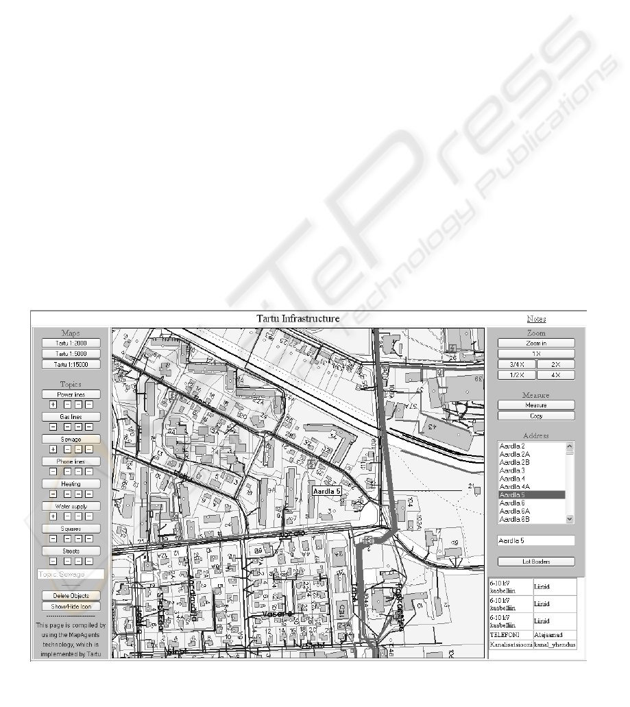
4.1 Participatory GIS
Participatory GIS for regional planning and
management was tested as an application example.
The aim of the application created for Tartu City is
to view and update (as a dynamic collection of
spatial and information frames integrated into one
application) the information distributed in databases
of different owners.
The task came from the city government, who
needs the information of different infrastructures
(gas-, water-, sewage-, heating pipelines, power
lines and phone lines) for planning activities every
day. In reality, the infrastructure is maintained by
different organizations and the information,
therefore, is also kept in different GIS and databases.
The prototype of the participatory GIS for the
tasks described above is implemented as a federation
of agents. This agent-based system provides the
updated information from different GIS and DB as
well as represents and manages the information
supplied by agents involved.
User can select one main theme and compare it
with different subthemes. The number of base maps
(provided by map agents) and different data
categories (provided by vector agents) used in
application depend on maps and data which are
available for users. As a result, users can have
overview of a set of infrastructure of the area they
are interested, e.g. the location of pipelines,
availability of gas line or central heating system etc.
First experience shows that dynamic compilation of
frames intermediated by agents, offers reasonable
processing speed, better than that of a typical fixed
menu of web services of a traditional GIS.
Figure 3: Participatory GIS.
WEBIST 2005 - INTERNET COMPUTING
212
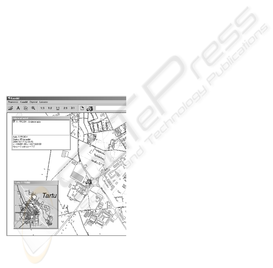
4.2 Tracking active objects
To include active or mobile objects in the
framework of geospatial agents, a prototype for
tracking vehicles was developed. As usually, a GPS
module, which is attached to moving object, receives
the signal from satellites and transmits the
coordinates with the unique ID of object to operator
agent. The agents provide the coordinate info of
particular object to map application. The map
application is built up as any other agent-based
application and active object acts as additional
agent.
The tracking multi-agent is a federation of
agents, consists agents of following types:
• agents processing fragments of the map;
• agents for searching, processing, and sending
the vector information for the image or situation
that has been activated in the map_object
• GPS agents, that in pair with periodically
transmit to other agents the position of active
objects equipped with standard GPS device.
• agents that manage, search, and forward
additional information related to active objects.
5 CONCLUSIONS
The developed collection of agent classes forms the
basis of agent-based digital maps. The collection is
extendable and depends on tasks required by the
customer, types of digital base-maps, additional
databases to be used, and on other factors. Each
agent is to be programmed as required by the
specific application. Agents have generic features
that facilitate their usage in a variety of applications
with minimal modifications. The experience shows
that dynamic compilation of agents’ intermediated
map frames offers a reasonable processing speed,
better than that of a typical fixed menu of web
services of a traditional GIS.
In contrast to the traditional approach in GIS, the
geospatial agents empower developers and end-users
to build their custom maps independently and post
useful information for their clients. Advantages
include the shift of ownership from digital map and
GIS suppliers to the users and the opportunity for the
users to build their own dynamic and interactive
maps. This opens a venue for developing many more
and tailor-made applications.
The described agent-based solution provides the
basic ideology that can be extended for application
on mobile & thin platforms. Further experiments and
the development of the instrumental software and
classes of geospatial agents are planned, in pair with
carefully selected geospatial application areas.
ACKNOWLEDGMENTS
This research has been partially financed by
Estonian Science Foundation grant no. 4860, and by
grants no. 014 2509s03 and no. 018 2565s03 from
the Estonian Ministry of Education and Research.
This support is gratefully acknowledged.
REFERENCES
Bigus, J.P., Schlosnagle, D.A., Pilgrim, J.R., Mills, W.N.,
Diao, Y., 2002. ABLE: A toolkit for building multi-
agent autonomic systems. IBM Systems Journal, vol.
41, no. 3, 350-371.
McKee, L., 2003a. The Importance of Going “Open”.
Open Geospatial Consortium, White paper, 8 p.
www.opengis.org
McKee, L., 2003b. The Spatial Web. Open Geospatial
Consortium, White paper, 8 p. www.opengis.org
Motus, L., Meriste, M., Kelder, T, Helekivi, J., 2004.
Agent-based Templates for Implementing Proactive
Real-time Systems. Proc. Int. Conf. on Computing,
Communications and Control Technologies, Austin,
Texas, ISBN: 980-6560-17-5, 199-204.
Odell, J., Parunak, H., Fleischer, M., 2003. Modeling
agent organizations using roles. Software and Systems
Modeling. Springer, vol. 2, 76-81.
Figure 4: Tracking active objects.
ON GEOSPATIAL AGENTS
213
