
USING WIRELESS TECHNOLOGY TO DEVELOP A VIRTUAL
REALITY COMMAND AND CONTROL CENTRE
Damian Green, Neville Stanton, Guy Walker, Paul Salmon
BITLAB, Brunel University, Uxbridge, Middx, UB8 3PH, England
Keywords: Wireless Technology, Applications, Command & Control, Human Factors
Abstract: This paper investigates the applicability of wireless communication systems for use in a command and
control environment. Human positional data is transmitted over a wireless network. This data is then used to
update a highly accurately modelled real-time 3D environment of the surroundings, with avatars positioned
at the transmitted points. The data is displayed on a stereoscopic 3D screen enabling novel automatic
tracking of human movement and allowing for more rapid and informed tactical decision making. This
system has applicability in a variety of situations including Command and Control in essential services –
fire, rescue and military.
1 INTRODUCTION
Contemporary studies of command and control in a
variety of domains show significant shortcomings in
human performance.
A study by Baber et al (Baber, 2004) observed
an exercise on the Hazardous Materials course at the
Fire Service Training College in the UK. The
incident management comprises five phases: initiate
response to incident (1), perform initial incident
assessment (2), chemical identification (3), chemical
assessment (4), and resolve incident (5). From
Baber et al’s analysis, it is possible to see that the
information that could be drawn upon during the
incident becomes available to the performers at
different phases during the unfolding of the incident.
Thus, the fire-fighters are not aware that the child
has respiratory problems until around phase 4, or
that the farm is deserted until well into phase 3, i.e.
until arrival at the scene. With this knowledge, the
definition of response is made easier, the question of
which Personal Protective Equipment to wear can be
solved and the search strategy simplified. Thus,
Situation Awareness, from a system perspective, can
be viewed as the sum of knowledge relating to
specific topics within the system. The challenge in
incident management becomes one of ensuring that
the appropriate agents have access to appropriate
knowledge of topics at the right time.
With a view to military applications, friendly-
fire remains a problem for even the most wired
military in history, with aerial and artillery attacks
the most serious. So far, 18 of the 149 fatalities
suffered by U.S. and British soldiers in Gulf War II
were the result of errant strikes by coalition forces.
These tragic numbers appear to be an improvement
over Gulf War I, which recorded 35 deaths from
friendly fire - 24% of all combat fatalities, vs. 12%
in Gulf War II. But the U.S. and its allies deployed
twice as many troops in the first Gulf conflict. And
as the Pentagon gathers the final data from the war,
the number of friendly-fire deaths could increase.
Although the risks of armed conflict on a Cold
Ware scale may be lower, there is increasing
turbulence world-wide, with persistent mid to low-
intensity threats, a trend that is likely to (Robinson,
2003) continue. Throughout the Cold War, nations’
military forces prepared for conventional war – tank
against tank, ship against ship and plane against
plane. Within the past decade, the use of military
force characteristically has not been state-on-state
but more typically exercised in regional
engagements in peacekeeping, peace enforcement
and disaster relief. Armed conflict continues to
become more complex and to require even greater
precision (Hubbard, 2003). Providing armed forces
with new capabilities is essential (Hubbard, 2003).
This work’s primary purpose is to investigate the
applicability of modern technology to save lives in
essential services and to reduce unnecessary friendly
fire incidents.
52
Green D., Stanton N., Walker G. and Salmon P. (2004).
USING WIRELESS TECHNOLOGY TO DEVELOP A VIRTUAL REALITY COMMAND AND CONTROL CENTRE.
In Proceedings of the First International Conference on E-Business and Telecommunication Networks, pages 52-59
DOI: 10.5220/0001393500520059
Copyright
c
SciTePress
1.1 Related Work
One technology developed to reduce friendly fire is
the Battlefield Target Identification (BTID), an
updated version of the Battlefield Combat
Identification System (BCIS). BTID uses
transmitters (as did BCIS) that aim very shortwave
bursts of communication data at a target just before
letting go a salvo. If the target responds with the
correct encrypted reply indicating that it's a friend
then the gunner's sight will turn red. The system is
accurate at distances of up to three miles (Science,
2003).
A second program is called Individual Combat
Identification System (ICIS). It comes in two parts: a
specialized laser sight mounted on a rifle and a
combination laser-detection device and radio
transponder mounted on a soldier's helmet. When a
soldier takes aim with the ICIS laser, the beam will
activate the detector if the person in the sights wears
the helmet of a U.S. soldier. The transponder will
then send an encrypted signal warning the shooter
not to fire. ICIS uses off-the-shelf components and
weighs less than two pounds. It can run for 30 days
on a single camera battery.
Soldiers who already carry 70 pounds of
equipment on their backs cannot carry a heavy
broadcast device powerful enough to reach fighter
bombers. And those devices would need to generate
a signal in a radius of 360 degrees to be able to warn
not only planes but tanks and other soldiers.
Better networks for the military should make it
easier to avoid friendly fire incidents. Many support
units in Iraq lacked standard radios, let alone high-
tech communications devices. Key questions remain
as to how to fit friendly-fire information into a
decision that usually involves but a few seconds.
The right choice can make the difference between
blowing up allies or taking fatal fire and casualties
from an enemy. Friendly-fire deaths could remain an
inevitability of battle for years to come.
This paper sets out to investigate the various
technologies applicable for carrying out wireless
communication of human positional data with a
view to the communication of more detailed data
such as audio and video. 3D data is communicated
via a suitable network for the use in a command and
control environment which is carefully designed
around the human controller’s needs. This needs-
analysis is determined using human factors methods.
Such methods include task analysis techniques,
observational studies, verbal protocol analysis,
critical decision method, social network analysis and
coordination demand analysis (Stanton, 2004).
2 THE TECHNOLOGY
To provide front line forces with world class
systems these have to be developed from the outset
with the human operator in mind. The purpose of
this research is to investigate the possibility for the
wireless transmission and receiving of data to and
from a person in the field (PINF) to a command and
control centre (CC). The purpose of this work is to
create processes and methods which will be
integrated as part of future systems.
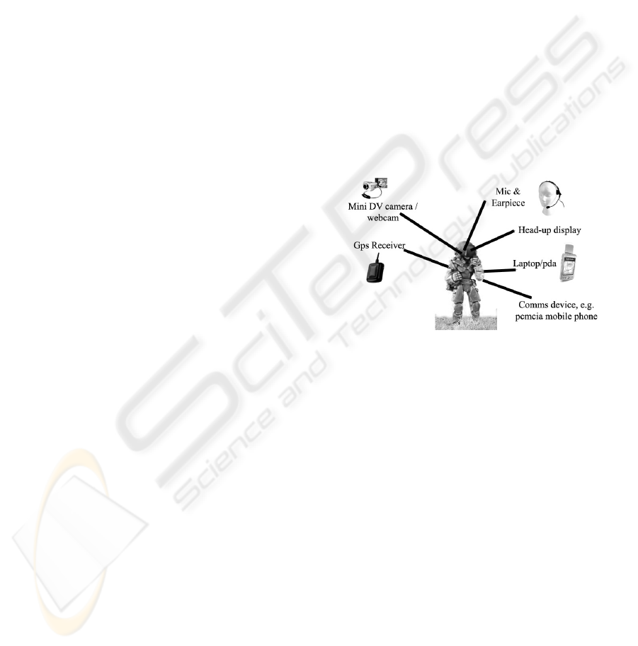
Figure 1: PINF Hardware
The data transmitted from the person in the field
may include Global Positioning System data (GPS),
Differential GPS (DPGS), audio and video (AV).
The data received back to the PINF from the CC
may include GPS data of other personnel on the
field, and relevant video data,
Figure 1. If GPS data of ally positions is received by
the PINF, a variety of methods can be used for the
displaying of this data on a headset, (radar notation
etc).
Figure 1 illustrates example hardware technology
that may be adorned by the PINF.
USING WIRELESS TECHNOLOGY TO DEVELOP A VIRTUAL REALITY COMMAND AND CONTROL CENTRE
53
Internet
WLAN /
GPRS
MFC IVF (C++ )
Stereo
Application
Winsock
component
Server
Satellite Satellite Satellite
Laptop
GPS
Receiver
PDA
PDA
g
Large Screen X 3
CRT
projector
X 3
Router
High-Power
Rendering Machines with
Dual-Head Graphic Card
COMMAND & CONTROL
Figure. 2: Overall System Concept
2.1 Hardware Options for Wireless
Position Communication Using
GPRS
To demonstrate a proof of concept, various
commercially available technologies were
investigated for their applicability. It should be
noted that for real-world military application, these
technologies may not be secure, fast or reliable
enough. The main drive of this research is to
demonstrate the 3D technology; however, much of
the technology which may be suitable for this kind
of application is still under development. The
following sub-sections suggest various commercial
off the shelf (COTS) hardware configurations.
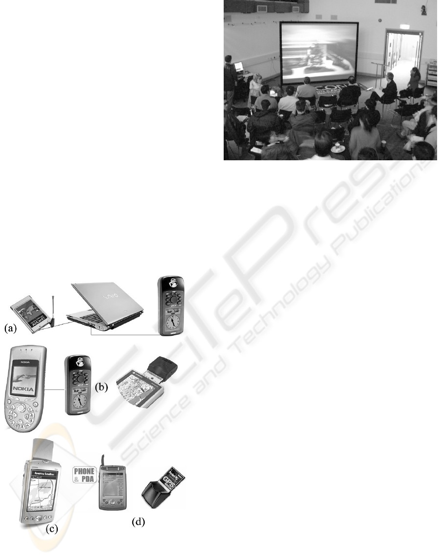
2.1.1 Laptop and GPS Receiver with WLAN
Card
An initial proposal for the PINF hardware may
include a compact laptop, for example the ultra
lightweight (4.39 lbs) and compact design Sony
VAIO® V505DC1 Notebook, connected to a GPS
receiver via an RS232 cable, which is in turn
connected to a wireless LAN card internally or
through the PCMCIA slot, Figure 3a. With the
option of external amplified antenna and PCMCIA
option the NavRoute WAAS enabled GPS HP-60
device can be used in a notebook computer. Further
investigation is needed to determine whether the
GPS position can be constantly streamed from this
device. The advantage to this configuration is high
processing power, which may be necessary when
streaming and compressing video data. The
downside is the lack of compactness and the
inherent superfluous technology – keyboard, LCD
screen.
2.1.2 PDA With Inbuilt GPRS With GPS
Compact Flash Device
A second possibility requires using a more compact
device, such as a Personal Digital Assistant (PDA)
with inbuilt GPRS and a Compact Flash GPS
Receiver device plugged in, as shown in Figure 3b.
The disadvantage to using PDAs is the lack of
processing power needed to perform video
compression (which may be required on future
prototypes). A PDA that includes a relevant
Software Development Kit (SDK) for developing
streaming applications would need to be chosen and
evaluated. The NavRoute WAAS enabled GPS HP-
600 is compatible with PDAs with a Compact Flash
socket.
2.1.3 PDA with Inbuilt GPRS and GPS
A third possibility may be through the use of a PDA
with inbuilt GPS and GPRS as shown in Figure 3c.
ICETE 2004 - WIRELESS COMMUNICATION SYSTEMS AND NETWORKS
54

A study is needed to determine the suitability of any
available SDK exist for each specific PDA model.
The model shown is the Garmin iQue 3600 with
built in GPS PDA.
Disadvantages to the possibilities identified in
sections 2.1.2 and 2.1.3 include the lack of sockets
for the attachment of devices such as webcams and
microphones for further communication. The
webcam on the PDA itself may not be sufficient
because it would need to be held near the PINF’s
head. It is more advantageous to have the PDA
separate from acquisition technology.
2.1.4 Local Positioning Systems (LPS)
LPS originated from the operating concepts of the
global positioning system (GPS) satellite network,
which takes signals from orbiting satellites to track
large out-door assets, such as automobiles, trucks
and railway cars.
GPS signal is too weak to penetrate walls and
other obstacles and its commercial resolution is too
imprecise to provide meaningful location data for
indoor applications. Using these technologies and
methods, LPS uses electronic tags, discreet antennas,
and low-power radio signals to instantly locate,
track, secure and inventory assets. It is ideal for
stationary assets, such as large physical inventories,
or for mobile assets, including people and portable
equipment.
PDAs can be used in conjunction with custom-
built hardware devices which receive VHF/UHF
singals and triangulate. This position can then be
sent using the PDAs over a wireless LAN or using
GPRS.
2.1.5 WLAN Triangulation
A laptop wireless can be used in conjunction with
triangulating software. Ekahau (Ekahau, 2003) have
developed enhanced position determination software
to allow positional information to be derived from
triangulation by WLAN access points. The Ekahau
Positioning Engine™ (EPE) is a positioning server
that provides PC, PDA, and asset TAG location
coordinates (x, y, floor) and tracking features to
client applications. EPE uses a stand-alone manager
application for drawing the Ekahau Tracking
Rails™, recording site calibration data, tracking
wireless devices on map, and statistically analyzing
the positioning accuracy.
Ekahau's positioning technology has an average
accuracy of up to 1 meter (3½ ft), enabling people
and asset tracking both indoors and outdoors. This
opens up the possibility of WLAN networks being
deployed purely for indoor tagging and tracking
purposes – an application area currently dominated
by proprietary tagging solutions. Ekahau Manager is
used to create a positional model – A floor-plan or
map image (BMP, JPG, PNG) is opened and Ekahau
Tracking Rails are drawn on the map to increase
positioning accuracy and stability. The Positioning
Model is created by moving around the area while
clicking the map to record sample points containing
received signal strength intensity (RSSI) samples.
No information about the access point locations is
required.
2.1.6 Command and Control
Communication Hardware
If GPRS is used as the communication medium, at
the CC end, one GPRS phone with contract is all
that is required, and the CC connects to the mobile
device through a standard network connection. If the
CC is non-mobile and network capable then this is
no problem. The O
2
company offers such an ISP
connection. However if the CC is mobile yet is still
in the vicinity of mobile phone base-stations then a
GPRS card and dedicated phone line is necessary.
For the CC environment, a large Stewart stereo wall
was used (Figure 4) (Corporation, 2003).
If WLAN is used as the transmission medium, a
connection to the Internet is all that is needed at the
CC end.
2.1.7 Hardware Options Discussion
Some of the PDAs described have GPRS
transmission capability. In absence of a WLAN, this
may be a viable communication medium. The
emerging standard of Universal Mobile
Telecommunications System (UMTS) may be more
appropriate. UMTS represents an evolution in terms
of services and data speeds from today's "second
generation" mobile networks. UMTS is the natural
evolutionary choice for operators of GSM networks,
which currently represent a customer base of more
than 850 million end users in 195 countries and
represents over 70% of today's digital wireless
market
The Ekahau solution sounds like a good
approach for indoor triangulation or in cases where
WLAN coverage is great and GPS is unavailable.
The accuracy is not enormous however and it
requires significant pre-calibration. It is difficult to
imagine how the deployment of WLAN devices and
the creation of positional models would be useful for
anything other than the development of aesthetically
pleasing prototypes for a system which would later
use alternative positioning technology. The fact that
the software requires 5 MB of RAM may hinder its
use on PDAs.
USING WIRELESS TECHNOLOGY TO DEVELOP A VIRTUAL REALITY COMMAND AND CONTROL CENTRE
55
PDAs using the Pocket PC operating system
(OS) capable of GPRS are available on most of the
HP modern HP series; Jornada, iPaq 5500, 5550 and
so on. Combined with a Pretec Compact GPS card, a
small portable wireless programmable GPS solution
can be realised. This combination is shown in Figure
3. However if the device is in the vicinity of a
WLAN then a PDA which has integrated WLAN
802.11b such as the HP 5500 would allow free
transmission of position in areas with WLAN
coverage, such as the environment mentioned. One
which requires a plug-in WLAN is unsatisfactory
because there is then no space to include a GPS
receiver.
Outdoors, GPS devices are easily hampered by
adverse weather conditions – cloud cover etc.
Bluetooth wireless technology is designed to
replace cables between cell phones, laptops, and
other computing and communication devices within
a 10-meter range. As such it is not useful for the
transmission of GPS data to a remote CC, although
it may have useful applications for local PINF
communications (comms). Wi-Fi is wireless
network; it provides an extension or replacement of
wired networks for dozens of computing devices.
Figure 3: Candidate Hardware Configurations for Client
Position Communication Device a) Compact PC with GPS
receiver connected via GPRS Wireless PCMCIA card. b)
PDAs with GPS. c) PDA with inbuilt GPS. d) PDA with
GPRS and CF GPS
Figure 4: Command and Control Centre shown on a stereo
Stewart Screen at the Bitlab, Brunel University, UK
2.2 Developing a GPS Receiving
GPRS PDA Application
A variety of PDAs were acquired for development
purposes, including the HP Jornada which has GPRS
and a CF slot for a GPS device, as well as numerous
IPaq 5550s which have both WLAN capability and
CF slot for GPS receivers. The Microsoft Visual
Studio .NET Application Wizard was used to create
a Visual Basic Smart Device Application. The
.NET Compact Framework is a hardware-
independent environment which can run programs
on resource-constrained computing devices,
encompassing personal data assistants (PDAs) such
as the Pocket PC, mobile phones, set-top boxes,
automotive computing devices, and custom-designed
embedded devices built with the Windows CE .NET
operating system.
The number and members of classes differ from
what is available for developing desktop
applications. Fewer classes are available for devices
using the .NET Compact Framework (for example,
Web forms, remoting, messaging, management, and
printing are not supported), and the enumeration of
classes typically differs among platforms.
ICETE 2004 - WIRELESS COMMUNICATION SYSTEMS AND NETWORKS
56
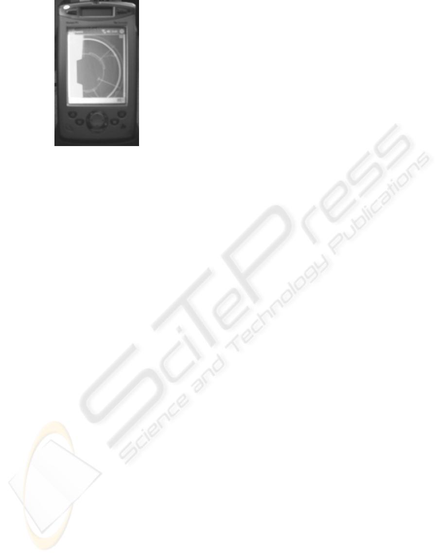
Figure 5: An Early GPS Radar Application
Running on an HP Jornada PDA
2.2.1 Receiving GPS
Programs which allow communication with GPS
devices were investigated. An example VB
application which communicates between a PDA
and GPS device was found on MSDN (MSDN,
2003). However it required the use of a COMM
control. Visual Studio .NET does not have this
control as standard and Visual Studio 6, or VB 6.0
needs to be used, or through a technique known as
Interop. Interop is hidden from the programmer by
Visual Studio so that it looks like another .NET
control. Using Interop adds an unneeded level of
complexity and performance penalty to programs.
An early prototype of a client application which uses
GPS positioning and a radar type interface is shown
in the photograph in Figure 5.
2.2.2 Communication
An initial protocol was developed for the
transmission of multiple person positions to test the
principle.
<stx><P><id><999888777><etx><chk>
where..
P is the position of the person (x,y,z)
id is a unique number identifying the
person who’s position is being tracked
etx is x03h (a unique header)
stx is x02h
chk is a checksum of the previous bits
for error detection
2.3 Command And Control
To develop a Command and Control application
which communicates with wireless technology and
displays this data in 3D stereo in real-time, careful
consideration needs to go to the choice of software
platform.
Visual Basic provides rapid application
development (RAD) but is lacking in fast real-time
3D graphical display. The use of the OpenInventor
(OIV) IVF interface library for gluing Inventor to
Microsoft Foundation Classes (MFC) works well
using the C++ platform (TGS, 2003). The purpose of
the IVF class library is to simplify integration of
functionality provided by the Open Inventor Win32
Classes with MFC-based applications. IVF builds
upon the application framework provided by MFC to
deliver the additional functionality of Open Inventor
in a manner familiar to MFC developers.
A "socket" is an endpoint of communication: an
object through which an application communicates
with other Windows Sockets applications across a
network.
MFC contains two different classes for
communicating via sockets (WinSock) (Microsoft,
2003). TGS’s OIV allows for rapid development
through its Visual Studio AppWizard extensions. It
also allows for easy stereo extensibility to
applications, which is necessary for command and
control visualization on the screen shown in Figure
4.
A preliminary application has been developed
which uses the aforementioned technology as shown
in Figure 6. The application imports a 3D model in
the VRML format (.iv) of the environment over
which data is wirelessly communicated. This has
been modelled from AutoCAD survey data from the
estates department of the university and using the
theodolite measured point and line data to extrude
areas of grass as a baseline for the modelling of
buildings. Some buildings have been left as
wireframe extrusions of survey data to show the
different representational schemes possible to the
commander. Further investigations will determine
the most useful representation of the situation. A
schematic diagram of the software configuration is
shown in Figure. 2. Initial tests of the software have
realized impressive update speeds, even on a
Alienware 3.2 GHz, 1GB RAM desktop machine.
2.4 Human Factors
Rather than suggest that one form of representation
suits all types of task, our proposal is to investigate
the appropriateness of each representation for each
aspect of the scenario and the decisions being made.
It is anticipated that more strategic, tactical and
operational tasks might require different types of
representation. For example, formulation of
strategies might best be supported by more abstract,
goal-oriented displays of information. Operational
tasks might be better supported by a physical
USING WIRELESS TECHNOLOGY TO DEVELOP A VIRTUAL REALITY COMMAND AND CONTROL CENTRE
57

analogue representation of the real world. Tactical
tasks might require both sorts of representation, or a
merging of the two forms of data.
Matching the team role to the representation
might be an overly constrictive approach to interface
design, but allowing members of the team to have
access to different representations of the scenario
relevant to the task that they are controlling may be
more fruitful.
Operational testing of the prototype environments
will be undertaken within an experimental paradigm.
First, we need to judge exactly what performance
gains can be made over conventional command and
control methods. Second, we need to discover what
process improvements there are to be made with
these new forms of command and control
technology. There may be additional performance
improvements to be realized by using the technology
to perform tasks more effectively.
General research questions into multiple agent-
based computing interaction needs to be addressed
It is inevitable that network enabled computing will
lead to new forms of interaction. As the task-
artefact cycle products, new artefacts produce new
tasks and new tasks produce new artefacts. Network
enabled technologies are likely to have a
considerable social component to the interaction,
supporting human-human interaction via computing.
3 CONCLUSIONS
Robinson et al. write that for sound legal and
operational reasons in our pluralistic society, we
shall require an audit trail of operational decisions
and consequences (Robinson, 2003). By virtue of the
fact that all movements are streamed over a network
in the approach described, human paths can be
recorded and later replayed with a minimum of
effort in a 3D environment. This allows for a better
criticism of tactics employed with the aim of
improving future tactics. This could provide useful
input to movement behavioral models such as those
developed by Reece (Reece, 2003). This research
project is still in its early stages and with the
intended Human factors investigations; detailed
testing of these technologies will likely unfold some
interesting results.
The accuracy of GPS signal, urban density,
weather conditions and wireless LAN coverage of
the environment are all limiting factors to the
approach’s usefulness. In a new, unmodelled and
unwired environment the full potential of this
technology would not be realized to the detail
shown. Although it is envisaged that the use of
photogrammetric approaches could be employed.
For example, an aircraft could be flown at a constant
altitude over the environment taking a series of
images; the images would then use feature matching
to create a coarse point cloud.
Future work with VR headsets and haptic devices
for more immersive visualization and interactivity
both at the CC and at the PINF side is a topic set to
be investigated.
There are many potential applications of the
technology in civil, military and emergency services
command and control. Any domain that has a
central command and distributed workforce has the
potential to benefit from the insights resulting from
this research.
ICETE 2004 - WIRELESS COMMUNICATION SYSTEMS AND NETWORKS
58
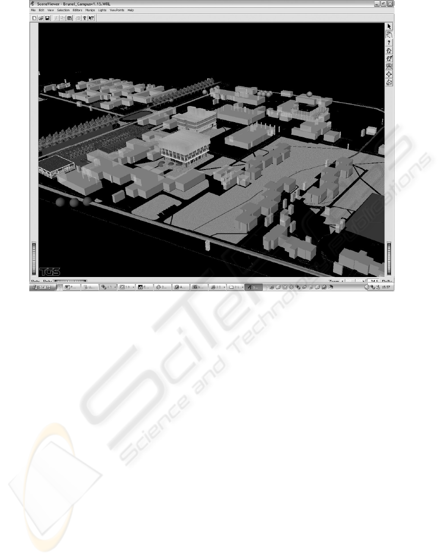
Figure 6: Proprietary OpenInventor Application Showing 3D Model of Environment Used for Wireless Positional
Communication
ACKNOWLEDGEMENT
This research was made possible by funds provided
by the UK Ministry of Defence through DSTL to
support the Human Factors Integration Defence
Technology Centre.
REFERENCES
Baber, C., Walker, G., Salmon, P., Stanton, N A. 2004.
Observation Study Conducted at the Fire Service
Training College. Human Factors Integration -
Defence Technology Centre Report. Fifth Conference
of Human Performance, Situation Awareness and
Automation Technology, Daytona Beach, Florida.
Corporation, Stewart Film Screen. Stewart Screens.
Accessed: 2003. http://www.stewartfilm.com
Ekahau. Triangulation Software. Accessed: 2003.
http://www.ekahau.com
Hubbard, M., Fentone, Col G . 2003. "Non-lethal
capabilities and the road ahead." Journal of Defence
Science 8(3): 210-214.
Microsoft. MSDN. Accessed: 2003.
http://msdn.microsoft.com
MSDN. Migrating a GPS App from the Desktop to
eMbedded Visual Basic 3.0. Accessed: 2003.
http://msdn.microsoft.com/msdnmag/issues/01/01/GP
S/default.aspx
Reece, Douglas A. 2003. "Movement Behavior for Soldier
Agents on a Virtual Battlefield." Presence
(Teleoperators and Virtual Environments) 12(4): 387 -
410.
Robinson, P., Pickard, Lt Col I. 2003. "The UK approach
to future Command and Inform (C4ISR)." Journal of
Defence Science 8(3): 179-186.
Science, Federation of Military. Battlefield Combat
Identification System (BCIS). Accessed: 2003.
http://www.fas.org/man/dod-101/sys/land/bcis.htm
Stanton, N. A., Hedge, A.; Brookhuis, K.; Salas, E. and
Hendrick, H 2004. The Handbook of Human Factors
and Ergonomics., London: Taylor and Francis.
TGS. TGS Open Inventor. Accessed: 2003.
http://www.tgs.com
USING WIRELESS TECHNOLOGY TO DEVELOP A VIRTUAL REALITY COMMAND AND CONTROL CENTRE
59
