
Customizable Navigation on Mobile Devices for
Physically Impaired People
Christoph Boßmann and Bettina Harriehausen-M
¨
uhlbauer
Dept. of Computer Science, Univ. of Applied Sciences, Sch
¨
offerstraße 8B, 64295 Darmstadt, Germany
Keywords:
WheelScout, Wheelchair, Navigation, Mobile, Barrier-free, Impaired, Mobility-impaired, Routing, Outdoor,
Customization, Profile.
Abstract:
Physical disability means for affected persons a substantial restriction in their everyday life. A significant
number of people throughout Germany were physically disabled, a not inconsiderable proportion of whom are
in wheelchairs. Current market-relevant navigational systems such as Google Maps still do not provide profiles
for mobility-impaired people or people in wheelchairs. With WheelScout it aims to create a navigational
system for mobile devices that enables these people to make their way alone, meaning without being routed
across barriers such as stairways or uneven surfaces. In this paper, it is shown how such a system can be
developed and how its essential features, including the ability of individual customization for its users, can be
realized.
1 INTRODUCTION
In 2019, more than 4.6 million people are physically
disabled across Germany (Destatis Statistisches Bun-
desamt, 2020). Among, approximately 1.4 million
people are in wheelchairs. This corresponds to 17.7%
of the severely disabled and 1.68% of the total popu-
lation in Germany (nullbarriere.de, nd).
In article 9 of the United Nations Convention on
the Rights of Persons with Disabilities, the declaration
states that the member states shall take appropriate
measures to ensure that persons with disabilities have
access to the physical environment and transporta-
tion as well as facilities and services that are open or
provided to the public (United Nations, 2006). That
about half of the more than 1700 reported barriers
on the map called Weg mit den Barrieren, in English
Get rid of the barriers, is caused by lack of mobility,
makes an otherwise sobering impression concerning
those claims (Sozialverband VdK Deutschland e.V.,
2016).
Further, article 20 states that member nations shall
take adequate measures to ensure personal mobility
with the highest possible independence for persons
with disabilities. That also includes facilitation of
new technologies (United Nations, 2006). If disabled
persons are familiar with their surroundings, they can
benefit from structural changes towards accessibility.
However, in many cases, people want to be able to be
mobile independently, even in unfamiliar areas. Al-
though using a conventional navigational system such
as Google Maps is convenient for citizens without any
impairment, it might be somewhat frustrating for in-
dividuals with physical impairments, as those apps
do not yet provide profiles, designated for people in
wheelchairs.
Therefore, with WheelScout it was the aim to cre-
ate an alternative to conventional navigational sys-
tems in terms of the accessibility of route for phys-
ically impaired people. Thus, in a way, the develop-
ment of a navigational system for physically impaired
people seeks to take the independence of personal mo-
bility by assistive technologies into account which is
claimed in article 20 of the United Nations Conven-
tion on the Rights of Persons with Disabilities men-
tioned above.
In the development of this project, Darmstadt
University of Applied Sciences is working closely
with the Independent Association of Civil Invalids
(LAPIC-UVZ Onlus: Independent Association of
Civil Invalids) in Bolzano, which is providing advi-
sory as well as financial support for the development
of this navigational system named WheelScout.
244
Boßmann, C. and Harriehausen-Mühlbauer, B.
Customizable Navigation on Mobile Devices for Physically Impaired People.
DOI: 10.5220/0010527002440255
In Proceedings of the 7th International Conference on Information and Communication Technologies for Ageing Well and e-Health (ICT4AWE 2021), pages 244-255
ISBN: 978-989-758-506-7
Copyright
c
2021 by SCITEPRESS – Science and Technology Publications, Lda. All rights reserved
2 RELATED WORK
In this section related products as well as useful com-
ponents involved in the development of this naviga-
tional system are introduced and described.
2.1 OpenStreetMap
Fundamental for the realization of a navigation sys-
tem is a suitable map material. OpenStreetMap
(OSM) has proven to be a suitable source for the pur-
pose. It is a free project that collects and structures
geodata and makes them available for use by any-
one for any purpose (Open Data). The map mate-
rial is created by its diverse, passionate, and every
day growing community (Community Driven) (Open-
StreetMap, 2021).
Besides that, the major advantage of this particular
purpose is a large amount of data about potential bar-
riers such as stairways or uneven surfaces. The share
of the most popular surface types in OSM worldwide
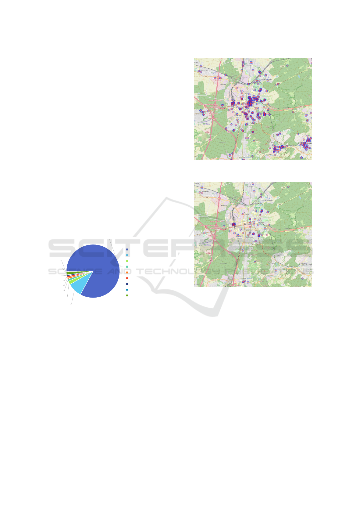
among highways is illustrated in figure 1. Highways
are any type of path, road, or street in OSM (Open-
StreetMap contributors, 2021).
79,96%
8,46%
2,08%
1,23%
0,88%
0,85%
0,68%
0,10%
1,87%
no data
surface=asphalt
surface=paved
surface=ground
surface=gravel
surface=concrete
surface=paving_stones
surface=cobblestone
other surface
Figure 1: Own visualization of data from https:// taginfo.
openstreetmap.org/ : Proportion of surface information
among highways worldwide on OSM.
It is noted that for a proportion of about twenty
percent details about the surface type are entered in
OSM. Comparing figure 2 and figure 3, it can be fur-
ther seen that in Darmstadt, Germany, for example,
many stairways are tagged but further details, such as
the number of steps or the presence of a handrail, are
not entered in most cases.
In conclusion, even taking into account the fact
that the information on roads and trails is far from
complete, OSM data can still be used as a source of
data regarding barrier information.
Figure 2: Overpass Turbo: Stairways in Darmstadt and sur-
roundings.
Figure 3: Overpass Turbo: Stairways in Darmstadt and sur-
roundings tagged either with handrail or step count infor-
mation.
2.2 GraphHopper
Further, it is necessary for the realization of a naviga-
tion system to use a suitable routing engine in order to
process routing requests accordingly. With regard to
the realization of a navigation system for people with
limited mobility, it is advisable to use an engine that
works with OSM data to take advantage from its fea-
tures described in section 2.1.
GraphHopper is a fast and memory-efficient rout-
ing engine programmed in Java that uses OSM data to
compute routes, which makes the routing engine plat-
form independently usable. It is licensed with Apache
license so it can be used modified and embedded into
other applications free of charge. It supports several
routing algorithms such as Dijkstra and A* as well as
the integration of elevation providers to consider in-
clines during route computation. A major advantage
Customizable Navigation on Mobile Devices for Physically Impaired People
245

of GraphHopper is its customizability concerning the
creation of different profiles for instance to represent
different vehicles as different profiles in GraphHop-
per (Karich, 2019b)(Karich, 2019a). For example, a
profile can be created that corresponds to the pedes-
trian profile but additionally avoids all stairways that
are tagged as such in OSM.
2.3 Open Route Service
Open Route service, developed and provided by
Heidelberg Institute for Geoinformation Technology
(HeiGIT), offers routing services by using user-
generated, collaboratively collected free geographic
data from OSM (Heidelberg Institute for Geoinfor-
mation Technology, 2019). The platform provides
the function of routing, based on profiles, including a
wheelchair profile, also through its newly developed
mobile application. This wheelchair profile is cus-
tomizable by its users, directly on the platform. For
instance, it can be customized to avoid cobblestone or
flattered cobblestone as ground surface during rout-
ing. Parameters such as the width or the incline of
a path can be customized as well. Furthermore, it is
possible to examine the percentage of a path consist-
ing of a particular type of surface. However it does
currently not support adding new barriers to the sys-
tem which is a major requirement four the work, see
section 3, and the profile settings are not fully cus-
tomizable (Google, 2021b).
2.4 Wheelmap and Accessibility.cloud
Wheelmap is a charity-based navigational service
available to the public for reading requests. The map
helps to find wheelchair-accessible places similar to
points of interest on Google Maps. Lots of places
such as grocery stores, shops, hotels, bars, restau-
rants, pharmacies, public parking garages, and many
more are listed in four different categories depend-
ing on whether the place is entirely, partially, or not
at all accessible or if the accessibility is unknown
(Krauthausen, 2010). While Wheelmap itself serves
as the frontend, the API named accessibility.cloud is
both backend and data source of it. The accessibility
information from this API is provided to the public to
be used in other applications as well. For scientific
purposes, its usage is free of charge. Both projects,
Wheelmap and accessibility.cloud are initiatives of
the non-profit organization SOZIALHELDEN e.V.
(accessibility.cloud, 2021).
Even though it is shown whether the place itself is
wheelchair accessible or not, the map does not show
if a wheelchair can handle the way to the place. Al-
though it hence cannot be used for routing directly, it
can help to find barrier-free points of interest such as
restrooms or stores that the user can navigate to.
2.5 Google Maps
The most popular navigation service, at least in the
western world, is Google Maps. Today, it is an in-
dispensable companion for almost anyone in daily
life (Poleshova, 2020). Although its usage is conve-
nient for vehicle drivers, cyclists, or just pedestrians
since suitable profile exists for each of those differ-
ent ways of transport, no such profile is available for
wheelchair users. This is a big limitation, considering
that stairways, uneven surfaces, and other insupera-
ble barriers may require users to find alternative ways
around them on their own. Even though Google intro-
duced a feature to find wheelchair accessible routes,
the service is currently only available in six cities, and
none of them is in Germany (Akasaka, 2020). Bring-
ing this together with the fact, that their API usage is
not free of charge (Google, 2021a), it is currently nei-
ther utilizable as a source for map material nor as a
navigational system for physically limited people it-
self.
3 METHODOLOGY
In this section, the feature requirements, the strategy
for the development process, and its resulting design
and architecture is explained.
3.1 Requirement Analysis
Since the navigation system is being developed in col-
laboration with this LAPIC association, mentioned in
section 1, the desired features were evaluated primar-
ily through surveys with mobility-impaired individu-
als from the association. Based on the result of the
surveys the following core features were elaborated:
• Routing under consideration of barriers such as
stairways, uneven surfaces, bottlenecks, and in-
clines.
• Creation of individual profiles to take into account
the physical limitations of the user in the routing
process accordingly.
• Adding new barriers or modification of existing
barriers to the system by its users. This includes
as well temporarily existing barriers such as fallen
trees or road constructions.
Since it turned out, as described in section 2.1, that
the database of OSM already contains a lot of relevant
ICT4AWE 2021 - 7th International Conference on Information and Communication Technologies for Ageing Well and e-Health
246
data for finding an accessible route, the integration of
the data of OSM is also a central requirement.
3.2 Design and Architecture
In this section, the design and architecture of
WheelScout is described. The basis for the design
process of the navigation system for WheelScout is
the chosen routing engine GraphHopper. Therefore,
all design, architectural and technical decisions must
fit the technical design and properties of GraphHop-
per. It is important to point out that due to newly
gained knowledge concerning the technical possibil-
ities of GraphHopper, the design of WheelScout has
changed multiple times. Corresponding designs were
always implemented to test the technical possibilities
of GraphHopper and the functionality accordingly.
3.2.1 First Design Approaches
It is important to point out here, that the underlying
routing algorithms of GraphHopper are graph-based,
meaning that all settings regarding routing behavior
must be set before the graph is rendered. That means
that whether a way or path should be considered as a
barrier and thus avoided or not must be decided in ad-
vance to the rendering of the graph, see section 4.1.1.
The first design based on this technical limitation is
described below:
• The routing process takes place on the server-side.
• The requirement for complete individual profiles
is waived, instead, various fixed profiles are cre-
ated among which the user can choose.
• Changes to barriers are stored in a database.
• Periodically, the graph is re-rendered to apply the
updated barriers to the graph so that they are taken
into account in future routing processes.
The disadvantage is, however, that on the server-
side, no fine-granular settings are possible, e.g. an
exact setting of the maximum number of manageable
steps on stairways depending on the existing handrail.
Also, the graph must be re-rendered each time barri-
ers are added, which must be considered a major dis-
advantage with a rendering time of about one hour
(Germany).
Another design approach is based on the possibil-
ity of setting the accessibility of edges after rendering
the graph which is possible through the GraphHop-
per high-level API. The design for this approach is
described below:
• The routing process takes place on the client-side.
• Barrier information are again stored in the server-
side database. Pre-rendered graphs are stored on
the server-side as well.
• The requirement of complete individual profiles
can be full-filled since the client stores the graph
on the client. If a user updates his or her profile,
the particular barrier information is fetched from
the database and applied to the graph locally.
A major disadvantage of this approach is that it re-
quires GraphHopper to run locally on the client which
limits its usage on platforms where Java can be exe-
cuted. That is why worthwhile development would
be limited to Android as it is the only market relevant
operating system for mobile devices which allows to
run Java code.
Therefore, a third and final design approach has
been developed where the routing engine has been
moved back to the server-side. To take advantage of
the 1st and 2nd approaches, i.e. server-side platform-
independent route computation together with en-
abling fine-granular profile adaptation, the design was
adjusted again which is described in section 3.2.2.
3.2.2 Final Design
Fundamental for the final design approach is that
GraphHopper allows setting accessibility of certain
edges of a graph to either true, meaning accessible, or
false, meaning not accessible, as already described in
section 3.2.1. Accordingly, in advance of each routing
request, only the accessibility of those barriers that do
not fit the user’s physical limitation, e.g., its profile, is
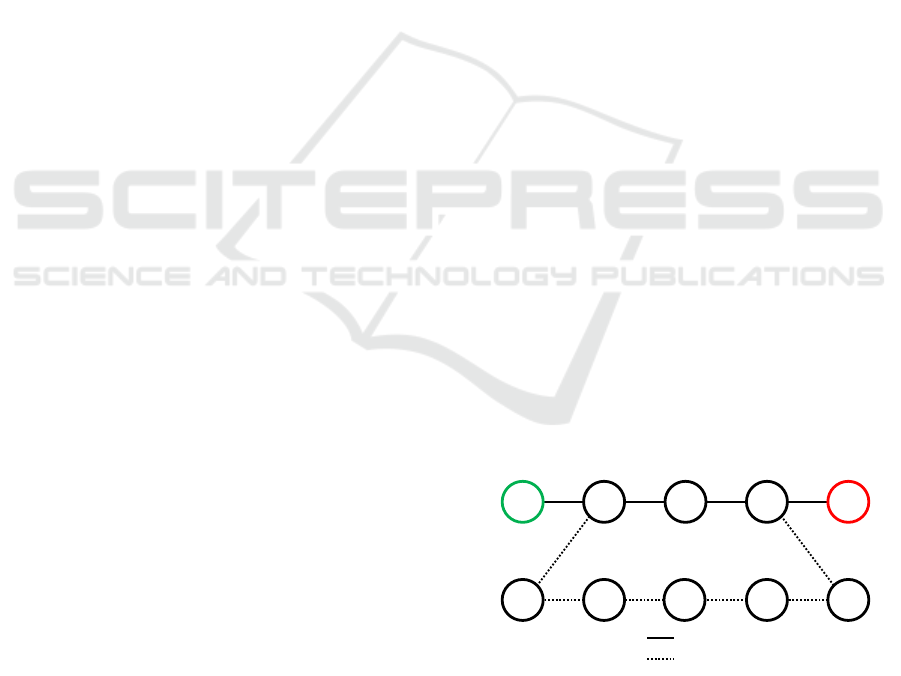
set to false. In figure 4 and figure 5 a minimal exam-
ple visualizes the edges taking normal route and tak-
ing a longer route if a certain edge is not accessible
e.g. there is a barrier.
Start
Destination
Edges passed for Route:
Other Edges:
Figure 4: Normal route.
A further issue that needs to be addressed is that
updating the accessibility can take multiple seconds
depending on the number of edges, e.g., barriers. Fur-
thermore, during this process, the GraphHopper in-
stance cannot compute any other route because the
Customizable Navigation on Mobile Devices for Physically Impaired People
247
Destination
Start
Edges passed for Route:
Other Edges:
Figure 5: Route if certain edge is not accessible.
updated accessibility would affect all routing requests
processed by GraphHopper on the same graph. That
is why the accessibility should only be updated for
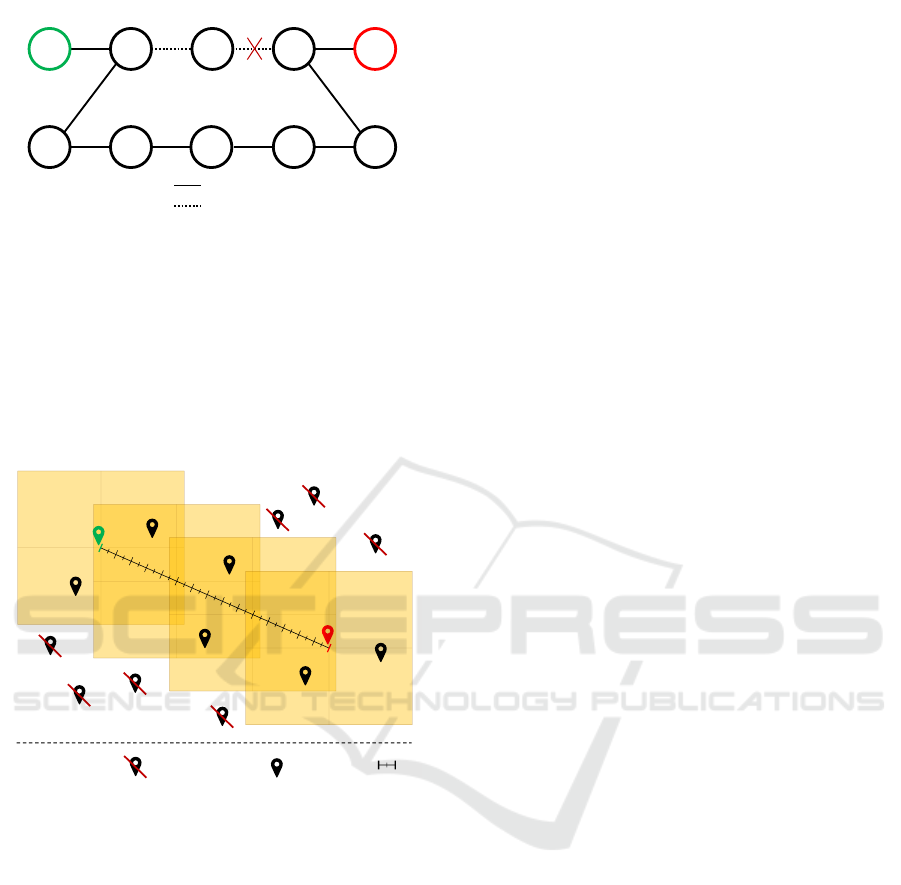
those barriers that are situated in the surroundings of
the actual route. Since the exact route is not known
before its computation, squares alongside the linear
distance with an appropriate buffer are calculated as
displayed in figure 6.
1 km:
Considered
Barrier:
Not considered
Barrier:
Figure 6: Calculated squares along-side of airline between
start and destination of route.
To speed up the process, only barriers within these
squares are considered for the route computation.
Considering that limited people often find their ways
in urban areas, a significant route deviation from the
airline was assessed as very unlikely and negligible,
based on numerous example routes. If such a doubtful
case would occur, it is still possible to inform the user
about the impossibility of computing the route. A fur-
ther approach is to pre-compute the regular route for
pedestrians to situate the squares as mentioned above
alongside this route to cover a route that deviates too
much from the airline. However, this approach has
not yet been pursued further. Instead, the mentioned
airline approach has been chosen.
3.2.3 Architecture
Under consideration of the feasibility study, described
in section 4.2, the in figure 7 visualized architecture
for WheelScout has been chosen. The architecture
consist of a mobile client as frontend that communi-
cates with an application kernel facade on the back-
end.
This system consists of several clusters on the
backend side, where each cluster is responsible for a
different area of the offered map material. An evident
subdivision is, for instance, the division by countries.
Accordingly, a cluster corresponds to a single coun-
try. The reason for preferring this approach is the in
section 3.2.2 already mentioned computation time of
a route. If a cluster’s load is expected to be higher,
a cluster can also be equipped with more than one
routing engine to enable parallel computation of more
than one routing request.
Further details concerning the implementation of
processing routing requests are outlined in section 4.
3.3 Testing
To verify the functionality of the system’s logic, re-
garding its correct computation of the route with
corresponding profile settings, the developed mobile
client is used by analyzing various computed routes
for various profile settings. However, to verify the
accuracy of computed routes without yet an existing
client, a tool named umap was used. umap enables
the visual representation of geographic information in
the GeoJSON format (OpenStreetMap contributors,
2019). The results of computed routes are presented
and discussed in section 5.
4 IMPLEMENTATION
In this section, the implementation of WheelScout is
outlined. First of all, the required adjustments to the
chosen routing engine GraphHopper are explained in
order to realize the in section 3.1 mentioned require-
ments of custom profiles. Then its integration into
a web server and the database for storing the barrier
data will be explained.
4.1 Routing Engine
GraphHopper and thus also OSM are set as compo-
nents, due to their advantages pointed out in sections
2.1 and 2.2. As the underlying algorithm of Graph-
Hopper for computation of routes is graph-based, the
ICT4AWE 2021 - 7th International Conference on Information and Communication Technologies for Ageing Well and e-Health
248
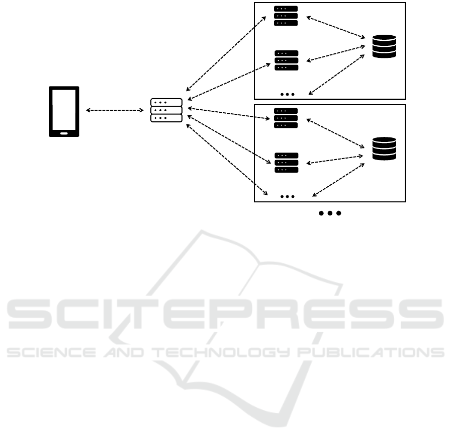
Application Kernel
Facade / Loadbalacer
Mobile Client
Cluster 1
Barrier
Database
Application Kernel /
Routing Instance
Application Kernel /
Routing Instance
Cluster 2
Barrier
Database
Application Kernel /
Routing Instance
Application Kernel /
Routing Instance
Figure 7: Architecture of WheelScout.
graph needs to be rendered in advance to route com-
putation. GraphHopper organizes its graph in edges
and nodes whereby each edge is connected to two
nodes or one node if there is no further connected
edge meaning the edge is an end. Contracted Hier-
archies (CH) are an additional mode that allows to
speed up the route computation process for longer
routes by creating so-called shortcut edges. However
they must be disabled in the usercase of WheelScout,
due to pre-procession the graph. It might result in
wrong routes if certain edges are being marked as not
accessible but CH is enabled 3.2.1 (Karich, 2020b).
4.1.1 Graph Rendering and Extraction of
Barrier Information
The creation of a custom profile is done by creating
a new FlagEncoder class that extends from another
FlagEncoder (Karich, 2019a) The method getAccess
can be overridden to define the accessibility for the
certain flagEncoder in the resulting graph based on
OSM tags which are consumed as parameters in the
method, as shown in the code extract below:
public EncodingManager.Access
getAccess(ReaderWay way) {
//[...]
if (way.hasTag("foot",
intendedValues))
return EncodingManager.Access.WAY;
//[...]
if (!allowedHighwayTags.contains(
highwayValue))
return EncodingManager.Access.
CAN_SKIP;
//[...]
return EncodingManager.Access.WAY;
To accomplish the in 3.1 demanded possibility of
individual adjustable user profiles on client side based
on their physical capabilities certain profile settings
should not be applied on the graph directly. That is
why potential barriers information are extracted dur-
ing the rendering process of the graph to be stored in
a database and then indivdually fetched and applied
for each routing request. To achieve that, the process
of extracting barriers through the method called ap-
plyWayTags is provided by the FlagEncoder as well.
This method is called for each edge together with its
particular associated OSM-Way that contains all the
parameters from OSM. In the code extract below the
extraction of a stairway and its number of steps is ex-
emplarily shown:
public void applyWayTags(ReaderWay way,
EdgeIteratorState edge) {
if(way.hasTag("highway", "steps")) {
Integer edgeId = edge.getEdge();
Integer baseNode = edge.getBaseNode();
Integer adjNode = edge.getAdjNode();
Long osmWayId = way.getId();
Integer number_of_steps = null;
if(way.hasTag("step_count")) {
number_of_steps = Integer.
valueOf(way.getTag("step_count"));
}
//[...]
//Write values into temp csv file
}
}
After finishing the graph’s rendering process, but
prior to the upload of them to the database, the coordi-
nates, meaning latitude and longitude values of each
edge, need to be extracted from the created graph.
Customizable Navigation on Mobile Devices for Physically Impaired People
249
The extraction is done through the usage of NodeAc-
cess as displayed below:
GraphHopper hopper; //object reference
NodeAccess nodeAccess = hopper.
getGraphHopperStorage().
getNodeAccess();
double baseNodeLat = Double.valueOf(
nodeAccess.getLat(baseNode)).
doubleValue();
double baseNodeLon =
Double.valueOf(nodeAccess.
getLon(baseNode)).
doubleValue();
double adjNodeLat =
Double.valueOf(nodeAccess.
getLat(adjNode)).
doubleValue();
double adjNodeLon =
Double.valueOf(nodeAccess.
getLon(adjNode)).
doubleValue();
double latitude =
Double.valueOf(
(baseNodeLat + adjNodeLat) / 2.0D));
double longitude =
Double.valueOf(
(baseNodeLon + adjNodeLon) / 2.0D));
4.1.2 Apply Barrier Information on the Graph
during Routing
In order to consider barriers during a routing request,
the particular barriers need to be applied prior to the
processing of the routing request. After the rout-
ing request has been processed, the prior application
of barriers needs to be undone. The technical im-
plementation is that the edge information stored in
the database, which consists of the edge id, the base
node id, and adjective node id, is first fetched from
the database. Subsequently, the accessibility of all
fetched barriers or edges is set to false. Those barri-
ers that belong to the edges will be considered as not
passable in the following route computation. After
the route computation, the process is reversed accord-
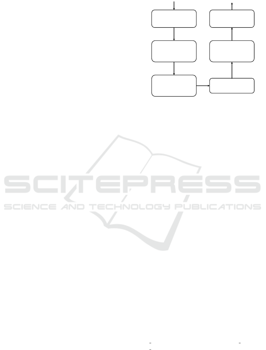
ingly. This whole procedure is visualized in the flow
chart diagram in figure 8.
In the code extract below the implementation
of the edge accessibility adjustment under usage of
GraphHopper is shown:
GraphHopper hopper; //GraphHopper reference
FlagEncoder encoder; //FlagEncoder reference
private static EdgeExplorer edgeExplorer =
hopper.getGraphHopperStorage().
createEdgeExplorer();
private static BooleanEncodedValue e =
encoder.getAccessEnc();
Receive routing
request from client
Fetch barriers from
database according to
filters
Apply fetched barriers
(set accessibility to
false)
Compute route
Reset fetched barriers
(set accessibility to
true)
Respond with
computed route
Figure 8: Processing a routing request including applying
individual profile settings.
public static EdgeIteratorState getEdge(
int baseNode, int adjNode {
EdgeIterator iter = edgeExplorer.
setBaseNode(baseNode);
do {
if(iter.getAdjNode() ==
adjNode) {
return iter.getEdge();
}
}
while(iter.next());
throw new Exception(
"adjNode not found!");
}
}
public static setAccessibility(
int baseNode, int adjNode,
boolean access) {
EdgeIteratorState edge =
getEdge(baseNode, adjNode
edge.set(e, access);
//forward
edge.setReverse(e, access);
//backward
}
4.1.3 Handling of Barrier Related Information
from OSM
In this section, the handling of relevant information
is explained. Currently, Stairway and Uneven Surface
are the two considered barrier types in WheelScout.
A stairway is tagged as Highway:steps. The at-
tributes, considered as relevant for stairways are:
step
count, handrail, ramp, width, step depth and
step height. Potential uneven surfaces are tagged with
either Key:surface or Key:smoothness. surface corre-
sponds to the type of surface and smoothness is the
passability of the way or path (OpenStreetMap con-
ICT4AWE 2021 - 7th International Conference on Information and Communication Technologies for Ageing Well and e-Health
250

tributors, 2021).
While the stairways’ attributes are suitable to be
filtered directly, it has been found that another at-
tribute Key:tracktype, especially in the countryside,
is clearly more present. Although not as accurate as
Key:surface, it is useful to consider this attribute as
a substitute when Key:surface or Key:smoothness are
not available.
For this reason, a filter called intell-surface-type is
developed to assign each intell-surface-type a suitable
value for Key:tracktype and Key:smoothness to each
surface-type.
4.2 Database
To store barrier information in order to fulfill the re-
quirements as described in section 3.1, the relational
database MariaDB, which is well established on the
market, was chosen for this purpose.
In the following, the core functionalities that
the database provides for the navigation system are
briefly summarized:
• Adding new and modifying existing barriers
• Removal of barriers
• Receiving barriers for either displaying them on
the client or applying them to GraphHopper, see
section 4.1.2.
• Importing barriers extracted during the graph ren-
dering process into the database.
4.3 Application Layer
In this section, the application layer consisting of the
application kernel and the application kernel facade /
loadbalancer is described.
4.3.1 Application Kernel
In addition to smaller, less essential functions, two
necessary functionalities are provided by the applica-
tion kernel. One is the functionality to provide the
client with the interfaces, mentioned already in sec-
tion 4.2, to access the barrier information stored in the
database. Client in this context refers to the end-user,
e.g., the mobile application, but also to the maintainer,
for instance, to update the barriers after updating the
map material. Second, the provision of an interface
for accepting and responding to routing requests by
forwarding them to the routing engine. Since the ac-
cess of the barrier database, is also used by the rout-
ing engine GraphHopper, it was decided to combine
the entire logic, including GraphHopper, in one com-
ponent. In figure 7, this entire logic is labeled as Ap-
plication Kernel / Routing Instance.
The interfaces were implemented as REST API
using the embedded Webserver Jetty. As data ex-
change format for barriers, routing requests, and other
minor functionalities JSON (JavaScript Object Nota-
tion) has been chosen. The combination of REST
and JSON is a common way to exchange data be-
tween client and server in business applications (Af-
sari, Kereshmeh et al., 2016).
The request below, shows an example routing re-
quest. The example request asks for a route between
two points. The filter parameters attached to the re-
quest allow only routes where passed stairways either
are equipped with a ramp for wheelchairs or have less
than 12 steps and a handrail:
curl --location --request GET ’{{host}}/route?
point=49.8712,8.6403&point=49.86772,8.64233&
vehicletype=wheelchair&instructions=true&
filter=ramp-wheelchair*EQ*true&filter=or&
filter=number-of-steps*LT*12&
filter=handrail*EQ*true’
Below, another example for a request, to receive
barriers in a certain radius, here 500 meters, for in-
stance to display them on the client:
curl --location --request GET {{host}}/
barriers?point=49.8712,8.6403&distance=0.5’
4.3.2 Application Kernel Facade / Load
Balancer
As described in the 3.2.3 section, the WheelScout ar-
chitecture supports running different maps on differ-
ent clusters to take advantage of scaling. For this
reason, it is necessary to actually forward all incom-
ing requests from the mobile client to the appropriate
cluster, e.g., Germany or Italy. To achieve that, the fa-
cade, which is implemented using Spring Boot needs
to be aware of the boundaries of each existing cluster.
The boundaries are represented as a polygon. Now,
the determination is actually done using an algorithm
called Ray casting algorithm. The algorithm sends
out a ray of the point in the direction to the minimum
square border of the polygon and counts the cross-
ings. If the number is odd, the point is situated within
the polygon, otherwise not (Taylor, G., 1997). In case
of no coordinates are provided in the request, such as
modifying an existing barrier by its id, the id has a
prefix to identify the cluster.
The second task is, as the name suggests, load bal-
ancing if more than one application kernel exists for
a certain cluster. As there are no special requirements
for load balancing, except that writing requests shall
only be processed by the first application kernel in a
Customizable Navigation on Mobile Devices for Physically Impaired People
251
cluster, a simple Round-robin scheduling is used for
all non-writing requests.
4.4 Client
In section 3.1, a client-side approach that performs
the routing on the client has been described. For this
approach, it was necessary to use Android as an oper-
ating system since Android is currently the only mar-
ket relevant operating system for mobile devices that
allows running Java code on it which is a must to ex-
ecute GraphHopper.
However, since the final approach requires to run
GraphHopper on the server and not on the client,
the Cross-Platform Mobile App Development Frame-
work called Ionic had been chosen for the develop-
ment of the client.
5 RESULTS
In this section, the results gained from the implemen-
tation for WheelScout, described in section 4, are pre-
sented and discussed.
5.1 Routing Results
A great number of different routes was continuously
tested to verify the functionality of the system. For
example, two different routes in Darmstadt have been
tested. One rather short route in the surroundings of
Hochschule Darmstadt with three different profiles
and one longer route with a single profile from
Darmstadt to Darmstadt-Wixhausen. Each route and
profile has been tested three times and was evaluated
with the number of passed nodes, distance, comput-
ing time, and total request time. The measured results
of the first route are shown for each profile setting
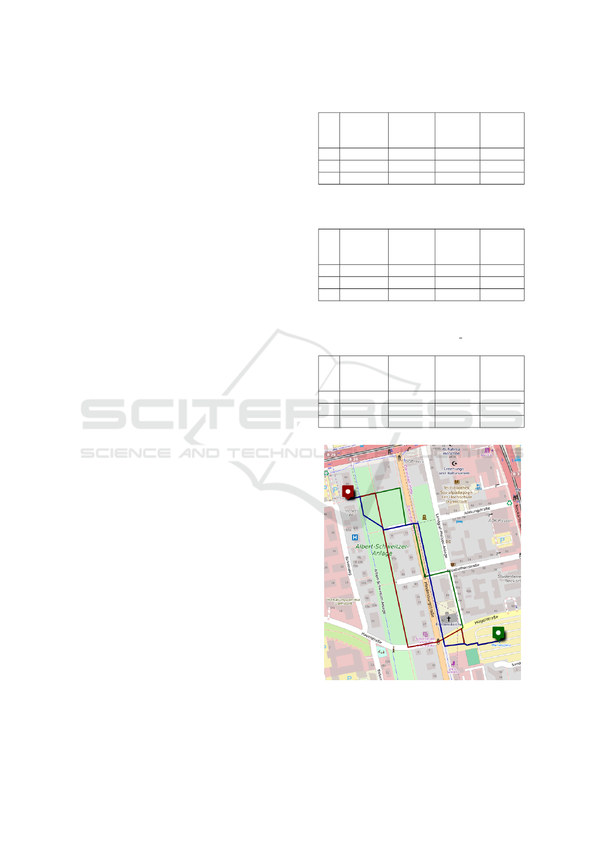
in the tables 1, 2 and 3. The route is also visualized
in a different color per profile setting in figure 9.
The range of barriers that are applied for the route
is visualized as an orange square in figure 10. The
measured results for the second route are shown in
table 4 and also visualized with its barrier range in
figure 11:
Route 1: Start: 49.86779,8.64460;
Destination: 49.87047,8.64016
Route 2: Start: 49.86779,8.64460;
Destination: 49.9335,8.6571
Table 1: Route color: blue, Applied filters: No filters.
Number
of passed
nodes
Distance Com-
puting
time
Total
request
time
1 14 580m 177ms 253ms
2 14 580m 188ms 364ms
3 14 580m 176ms 238ms
Table 2: Route color: green, Applied filters: Number of
steps < 12; only always accepted surface types.
Number
of passed
nodes
Distance Com-
puting
time
Total
request
time
1 14 615.85m 231ms 376ms
2 14 615.85m 244ms 380ms
3 14 615.85m 227ms 288ms
Table 3: Route color: red, Applied filters: Number of
steps < 12; accepted surface types: fine gravel, compacted,
pebblestone and always accepted surface types.
Number
of passed
nodes
Distance Com-
puting
time
Total
request
time
1 10 624.6m 236ms 519ms
2 10 624.6m 229ms 368ms
3 10 624.6m 242ms 306ms
Figure 9: Route 1, first profile: blue, second profile: green,
third profile: red -
c
umap,
c
OpenStreetMap contribu-
tors.
ICT4AWE 2021 - 7th International Conference on Information and Communication Technologies for Ageing Well and e-Health
252
Figure 10: Route 1, three routes, barrier range visualized as
orange square -
c
umap,
c
OpenStreetMap contributors.
Figure 11: Route 2, barrier range visualized as orange
squares -
c
umap,
c
OpenStreetMap contributors.
It can be seen that the barrier related information
about ways and paths from OSM, as already stated in
section 2.1, are sufficient to compute different routes
Table 4: Applied filters: Number of steps < 12; accepted
surface types: fine gravel, compacted, pebblestone and al-
ways accepted surface types.
Number
of passed
nodes
Distance Com-
puting
time
Total
request
time
1 120 8.4km 1366ms 1443ms
2 120 8.4km 1358ms 1503ms
3 120 8.4km 1348ms 1496ms
depending on the profile settings. Further, it is no-
ticeable that the computation time clearly increases
with the length of the route because of more needed
squares and thus more barriers to be considered.
5.2 Resulting Mobile App
Figures 12, 13 and 14 show some of the core func-
tionalities of the WheelScout app. Figure 12 shows
the above-introduced route but with uneven surfaces
allowed and stairways to be avoided. All existing bar-
riers in the surroundings are displayed by blue mark-
ers. The type of barrier depends on the symbol dis-
played on the marker. Figure 13 shows an example of
how the profile settings for stairways can be adjusted
in the app. Figure 14 shows how a missing stairway
can be added within the app.
Figure 12: Main screen of the app, route avoiding stairways.
Customizable Navigation on Mobile Devices for Physically Impaired People
253
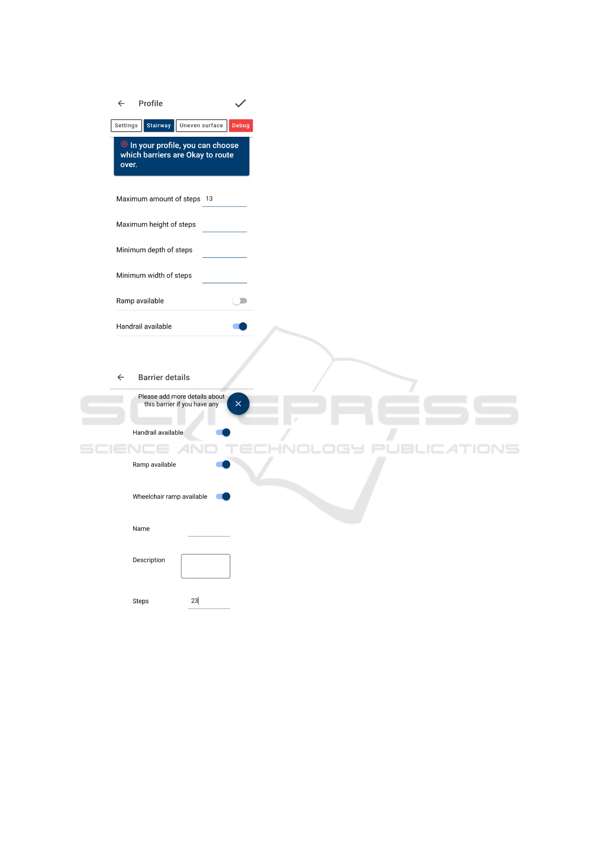
Figure 13: Adjusting profile settings screen, maximum al-
lowed steps 13, stairways must provide a handrail.
Figure 14: Adding new barrier screen, add a new stairway
that has 23 steps and that provides a handrail, a ramp and a
ramp for wheelchairs.
6 DISCUSSION AND OUTLOOK
WheelScout is still in an early stage of development.
Nevertheless, this work proved that it is possible not
only to develop a navigation system for physically im-
paired people with GraphHopper but also to make it
interactive, i.e., users can collaborate by extending the
barrier information. Moreover, it is shown that new
barriers are directly taken into account without caus-
ing delays, for example, due to the need to rerender
the map. This fact is a big advantage since OSM al-
ready provides much barrier related data. Anyway,
there is still a lot of data missing or not up-to-date,
see section 2.1.
The problem caused by the fact that longer routes,
i.e., 10km and more, have a longer computation time,
is less relevant, since wheelchair users mostly move
on short, inner-city routes. Furthermore, the provi-
sion of multiple routing engines within a cluster and
thus the ability to process parallel routing requests
can counteract the issue. Nevertheless, additional
routing engines also mean more resource consump-
tion. With an average computation time of 500ms,
the number of simultaneously processable routing re-
quests is therefore still limited. That is why the new
possibility added by GraphHopper to individually in-
fluence the computed route with properties such as al-
lowed surface-types or stairways could be very help-
ful (Karich, 2020a).
With the integration of Point of Interests (POIs)
functionality, which currently under development us-
ing data from the Accessibility Cloud, see section 2.4,
it will additionally be possible for users to navigate
for example to accessible restrooms or stores. This is
a great advantage for the user group, as not only the
accessibility of the POI itself but also the way to get
there can be determined in an uncomplicated way.
The option of using speech to operate WheelScout
is important as well for the user group since po-
tential users often have limited motoric abilities and
therefore cannot use the smartphone in the usual way
(Padır, Tasskın, 2015).
Finally, the integration of real-time traffic infor-
mation is also of high importance, especially for peo-
ple in wheelchairs, as it can be difficult for them to
make their way through crowds in busy pedestrian ar-
eas. As a result, traffic can also be a potential barrier
(Ding, Dan et al., 2007).
ACKNOWLEDGEMENTS
We thank the LAPIC and its members for their coop-
eration and support.
ICT4AWE 2021 - 7th International Conference on Information and Communication Technologies for Ageing Well and e-Health
254

REFERENCES
accessibility.cloud (2021). accessibility.cloud: Home.
https://accessibility.cloud/. Last checked on Feb 16,
2021.
Afsari, Kereshmeh et al. (2016). Javascript object nota-
tion (json) data serialization for ifc schema in web-
based bim data exchange. doi:10.1016/j.autcon.2017.
01.011. Last checked on Feb 16, 2021.
Akasaka, R. (2020). Introducing “wheelchair ac-
cessible” routes in transit navigation. https:
//www.blog.google/products/maps/introducing-
wheelchair-accessible-routes-transit-navigation/.
Last checked on Feb 16, 2021.
Destatis Statistisches Bundesamt (2020). Schwerbehinderte
menschen am jahresende.
Ding, Dan et al. (2007). Design considerations for a per-
sonalized wheelchair navigation system. doi:10.1109/
IEMBS.2007.4353411.
Google (2021a). Google Cloud. https://cloud.google.com/.
Last checked on Feb 16, 2021.
Google (2021b). OpenRouteService: Services. https:
//openrouteservice.org/services/. Last checked on
Feb 16, 2021.
Heidelberg Institute for Geoinformation Technol-
ogy (2019). openrouteservice.org: About.
https://maps.openrouteservice.org. Last checked
on Feb 16, 2021.
Karich, P. (2019a). Graphhopper routing engine: How to
create new routing profile aka a new flagencoder?
https://github.com/graphhopper/graphhopper/blob/
master/docs/core/create-new-flagencoder.md. Last
checked on Feb 16, 2021.
Karich, P. (2019b). Graphhopper routing engine: Readme.
https://github.com/graphhopper/graphhopper/blob/
master/README.md. Last checked on Feb 16, 2021.
Karich, P. (2020a). Examples for customizable rout-
ing. https://www.graphhopper.com/blog/2020/05/31/
examples-for-customizable-routing. Last checked on
Feb 16, 2021.
Karich, P. (2020b). Technical overview of graphhop-
per. https://github.com/graphhopper/graphhopper/
blob/master/docs/core/technical.md. Last checked on
Feb 16, 2021.
Krauthausen, R. (2010). Wheelmap.org: Faq. https://news.
wheelmap.org/en/faq/. Last checked on Feb 16, 2021.
nullbarriere.de (n.d.). Bedarf an barrierefreien woh-
nungen in deutschland. https://nullbarriere.
de/bedarf-barrierefreie-wohnung.htm#:
∼
:
text=Danach%20sind%20insgesamt%20rund%
201,in%20Deutschland%20im%20Jahr%202019.
Last checked on Feb 16, 2021.
OpenStreetMap (2021). About. https://www.
openstreetmap.org/about. Last checked on Feb 16,
2021.
OpenStreetMap contributors (2019). umap/guide/import
data files. https://wiki.openstreetmap.org/wiki/UMap/
Guide/Import data files. Last checked on Feb 16,
2021.
OpenStreetMap contributors (2021). Key:highway. https:
//wiki.openstreetmap.org/wiki/Key:highway. Last
checked on Feb 16, 2021.
Padır, Tasskın (2015). Towards personalized smart
wheelchairs: Lessons learned from discovery in-
terviews. doi:10.1109/EMBC.2015.7319518. Last
checked on Feb 16, 2021.
Poleshova, A. (2020). accessibility.cloud: Home.
https://de.statista.com/statistik/daten/studie/1174791/
umfrage/unverzichtbaren-apps-nach-altersgruppen/.
Last checked on Feb 16, 2021.
Sozialverband VdK Deutschland e.V. (2016). Barrierefreie
mobilit
¨
at ist den menschen am wichtigsten. https://
www.vdk.de/deutschland/pages/72149/barrierefreie
mobilitaet ist den menschen am wichtigsten. Last
checked on Feb 16, 2021.
Taylor, G. (1997). Point in polygon test. doi:10.31030/
2250588.
United Nations (2006). United nations conven-
tion on the rights of persons with disabili-
ties. https://www.un.org/disabilities/documents/
convention/convention accessible pdf.pdf. Last
checked on Feb 16, 2021.
Customizable Navigation on Mobile Devices for Physically Impaired People
255
