
Study on Carrying Capacity of Resources in Danjiangkou Reservoir
Area based on GIS Technologies
Ke Liu, Yuhang Gan, Zhengyu Luo and Fanghong Ye
Land Satellite Remote Sensing Application Center, Ministry of Natural Resources of P. R. China, Beijing, China
Keywords: Carrying Capacity of Relative Resources, Sustainable Development, Mid-Route of the South-North Water
Diversion Project, Danjiangkou Reservoir, GIS.
Abstract: The environmental health and green development of the water source area of Mid-Route of the South-North
Water Diversion Project (SNWDP) is not only essential for ensuring that “The clear water is sent to Beijing”,
but also an important prerequisite for sustainable development of society and economy in the water source
area. Based on national geographic survey data, basic surveying and mapping data and statistical yearbook
data, this paper used the model of relative carrying capacity of resources to estimate and analyze the carrying
capacity of relative natural resources (CCRNR), carrying capacity of relative economic resources (CCRER)
and carrying capacity of relative resources (CCRR) and their spatial-temporal changes in the Danjiangkou
Reservoir area of the water source area of the Mid-Route of SNWDP from 2009 to 2015 by Geographic
Information System (GIS) technologies. The results were shown that: (1) CCRR increased significantly
compared with that in 2009. However, CCRR in the study area was still overloaded in 2015. (2) CCRNR was
rich, but decreased from 2009 to 2015. (3) CCRER was in a overloading state, which increased obviously
from 2009 to 2015. The improvement of CCRER was the main reason for the sustainable growth of carrying
capacity in the study area. Therefore, the countermeasures including making rational use of natural resources,
developing economic resources and controlling population quantity were proposed to promote the sustainable
development of society, economy and ecology in the study area.
1 INTRODUCTION
The “China's National Land Plan Outlines (2016-
2030)” clearly states that China adheres the matching
of the national land development with its carrying
capacity, the coordination of agglomeration
development and balanced development, and the
promotion of development and protection to achieve
the high-efficient and sustainable spatial
development of national land and harmonious
regional development. As a basic essential to support
the system of nature, economy, and society, resources
and environment are playing a significant role to the
sustainable development of a country or a region.
Even since the early 1980s, UNESCO has
proposed the concept of carrying capacity of
resources. The resources carrying capacity of a
country or region is the maximum population size that
the area can sustain utilizing the energy and other
natural resources, as well as the conditions of
intelligence and technology given the grantee of the
material living standards complianced with its socio-
cultural rules. Therefore, the carrying capacity of
resources and environment is an important basis for
evaluating regional sustainable development (Feng,
2017). However, this concept only considers the
carrying capacity of natural resource homogeneously,
ignoring the complementarities between natural
resources and economic resources. At present,
extensive research have conducted by researchers on
CCRR in the provinces and cities such as Xinjiang,
Shandong, Changsha, etc., as well as in Yangtze
River Basin in China (He, et al. 2003; Huang, et al.
2010; Jing, 2006; Liu, 2002; Zhang, 2018; Yang,
2018), and single aspects such as cultivated land area,
crop sowing area and water supply amount are
selected as the key elements to estimate the regional
CCRNR in the research. Due to the differences of
environment, location and development level among
each region, inconsistencies between the results and
the actual situation is possibly existed led by this
evaluation method.
The Middle Route of SNWDP is the key project
related to the national economy and people's
livelihood, which can effectively alleviate the water
shortage in the north and support the sustainable
274
Liu, K., Gan, Y., Luo, Z. and Ye, F.
Study on Carrying Capacity of Resources in Danjiangkou Reservoir Area based on GIS Technologies.
DOI: 10.5220/0010468302740281
In Proceedings of the 7th International Conference on Geographical Information Systems Theory, Applications and Management (GISTAM 2021), pages 274-281
ISBN: 978-989-758-503-6
Copyright
c
2021 by SCITEPRESS – Science and Technology Publications, Lda. All rights reserved
development of economy and society by supplying
water to Beijing, Tianjin, Hebei, Henan and Hubei
provinces for urban domestic and industrial use and
for agricultural and other usages (Wang. et al. 2005).
The Middle Route of the South-to-North Water
Diversion Project is to divert water from the
Danjiangkou Reservoir in the upper and middle
reaches of the Hanjiang River, the largest tributary of
the Yangtze River. The main canal is excavated at the
head of the project in Xichuan County, Henan
Province, on the east bank of the Danjiangkou
Reservoir. Channels are excavated at the edge of the
central and western regions, passing through the
Yellow River through tunnels, going north along the
west side of the Beijing-Guangzhou Railway, and
flowing to the water delivery project of Tuancheng
Lake in the Summer Palace in Beijing. The main
water canals span the four provinces and
municipalities of Henan, Hebei, Beijing and Tianjin.
The water-receiving areas are 14 large and medium-
sized cities along the line. This project focuses on
solving the problem of water shortages in Henan,
Hebei, Beijing, and Tianjin, and providing water for
production, living, industry and agriculture for more
than a dozen large and medium-sized cities along the
route. The total area of the water supply is 155,000
km
2
, the total length of the main water canal is 1,277
kilometers, and the Tianjin branch line is 155
kilometers long.
After the Danjiangkou Dam was heightened, the
normal water level of the Danjiangkou Reservoir
reaches 170 meters to guarantee the future water
diversion amout. Appropriate compensation projects
have been carried out in the middle and lower reaches
of the Han River to ensure the industrial and
agricultural development, shipping and
environmental water in the transferred area while
transferring water to the northern region.
To guarantee a good natural ecological
environment of Danjiangkou Reservoir area, which is
a water resource area of water diversion, is the basic
premise to ensure the high-quality water supplying
for the regions of Beijing, Tianjin, Hebei, Henan, etc.
Thus, in order to provide suggestions for the
sustainable development of water source area, this
paper analyzed the resource carrying status in
Danjiangkou Reservoir area, estimating CCRR of the
productive land area considering various aspects
based on GIS technologies.
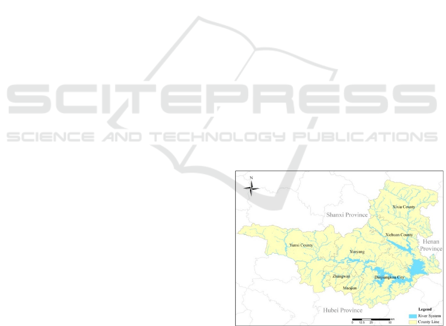
2 STUDY AREA
The study area located at the Danjiangkou Reservoir
and its surrounding cities and counties in the middle
route project of SNWDP with the range of
109.4°~111.9° E and 32.2°~33.8° N crossing Henan
Province and Hubei Province, with the total area of
17292.22 km
2
including 7 administrative units which
are Danjiangkou City, the districts of Maojian and
Zhangwan, as well as the counties of Xixia, Xichuan,
Yunxi and Yunyang (Figure 1).
The reservoir area is located in the subtropical
zone, with mild climate and abundant rainfall. The
average annual precipitation is about 1000 mm and
the average temperature is 15.6-16.0℃. The
surrounding mountains are high and steep, with
mountains and hills accounting for 97%. The plant
species are various, and resources are abundant. By
the end of 2015, the inhabitant in the study area was
34477,000, with a gross product of 220.93 billion US
dollars. The eco-environmental status between the
Danjiangkou Reservoir, which is the water source of
the Middle Route of SNWDP, and its surrounding
areas, has a direct impact on the quality of water
transfer and project benefits. However, with the
development of economy and society, the
contradiction of man-land relationship around the
reservoir area has become increasingly prominent.
The correct analysis and evaluation of the
comprehensive carrying capacity of the study area is
of great significance for coordinating and solving the
contradiction between human-land relationship
around the Danjiangkou Reservoir area and
promoting the sustainable economic and social
development of the region near the Middle Route of
SNWDP.
Figure 1: The location of the study area.
Study on Carrying Capacity of Resources in Danjiangkou Reservoir Area based on GIS Technologies
275

3 DATA SOURCE AND
RESEARCH METHODS
3.1 Data Source
3.1.1 Geoinformation Data
The first China Geography Census is an important
survey of national conditions, and it is a basic task for
understanding and grasping national conditions to
formulate national policies. We fully investigated the
current situation and spatial distribution of various
geographical national conditions, and mastered China
geographical national conditions. The first China
geography census has been accomplished in 2015,
while high precision land cover data were achieved.
The objects of this census were the natural and human
geography elements of the land surface of the whole
country (excluding Hong Kong, Macao Special
Administrative Region and Taiwan). Census content
included two parts. The first was the basic
information of natural geographic elements,
including geographic information such as topography
and landforms, vegetation coverage, waters, deserts
and bare land, such as categories, locations, scopes,
and areas, and their spatial distribution. The other part
was the basic elements of human geography Situation,
including geographic information such as railways
and roads, residential areas and facilities, geographic
units, etc., which are closely related to human
activities, and their spatial distribution status. This
census adopted the China Geodetic Coordinate
System 2000 (CGCS2000) and the 1985 national
elevation datum, using remote sensing images with a
resolution better than 1 meter acquired by airborne
and satellites platforms such as Worldview,
Quickbird, Pleiades and Geoeye.
1:50000 Digital Line Graphic (DLG) extracted
water system, road, residential area, vegetation, soil
quality, and other information about land surface
from aerial and satellite Digital Orthophoto Map
(DOM). It adopted the 1980 Xi’an coordinate system
and the 1985 national elevation datum. This research
extracted 5 classes of landcover including cultivated
lands, forests, grass lands (including wetlands),
construction lands and watersheds from the 1:50000
DLG of 2009 and the first national geographic
condition census of China by joining processing. Due
to the different contents and standards of the data
collected from two timelines, this paper consistently
processed the basic geoinformation of 2009 based on
the achievements of the first national geographic
condition census of China in 2015.
3.1.2 Thematic Data
The Gross Domestic Product (GDP) and permanent
population data used in this paper was from “China
Statistical Yearbook”, “Statistical Year book of
Shiyan City” and “Statistical Year book of Nanyang
City” and “the Statistics Communique on National
Economy and Social Development” in 2010 and 2016
(National Bureau of Statistics of China, 2010;
National Bureau of Statistics of China, 2016; Hubei
Provincial Statistics Bureau, 2010; Hubei Provincial
Statistics Bureau, 2016; Henan Province Bureau of
Statistics, 2010; Henan Province Bureau of Statistics,
2016).
3.2 Research Methods
3.2.1 Indicators
The sustainable development is a comprehensive
ecosystem composed by the subsystems of nature,
economy and society (Hao. et al. 2004), thus this
paper took natural and economical resources as the
main carrying resources. The natural resources were
represented by the productive land resource area of
ecological footprints, such as the areas of cultivated
land, forests, grass lands, construction land and
watersheds, while the economical resources were
represented by Gross Domestic Product (GDP).
Moreover, CCRNR, CCRER and CCRR were
calculated taking the livable cities as the referencing
area.
Livable city refers to the comprehensive
evaluation of the city's suitability for living. Its
characteristics are: beautiful environment, social
security, civilization and progress, comfortable life,
economic harmony, and high reputation. The "GN
China Livable City Evaluation Index System"
consists of 7 first-level indicators, including the
ecological environment health index, urban safety
index, convenience index, living comfort index,
economic wealth index, social civilization index, and
city reputation index. It is composed of 48 second-
level indicators and 74 third-level indicators (Zhang,
et al. 2016). The ranking of China's top ten livable
cities in 2015 are Shenzhen, Zhuhai, Yantai, Huizhou,
Xinyang, Xiamen, Jinhua, Liuzhou, Yangzhou,
Jiujiang.
3.2.2 Methods
CCRNR were described as the following,
C
rl
= I
l
* Q
l
(1)
GISTAM 2021 - 7th International Conference on Geographical Information Systems Theory, Applications and Management
276

where, C
rl
is CCRNR, Q
l
is the area of productive land
resources of the study area, I
l
=Q
p0
/Q
l0
is the index of
carrying capacity of natural resources, among which
Q
p0
is the population size of the referencing area, and
Q
l0
is the area of productive land resources of the
referencing area.
CCRER were described as below,
C
re
= I
e
* Q
e
(2)
where, C
re
is CCRER, Q
e
is the gross of the
economical resources of the study area, Ie=Q
p0
/Q
e0
为
is the index of carrying capacity of the economical
resources, among which Q
e0
is the gross of the
economical resources of the referencing area.
C
s
= w
1
* C
rl
+ w
2
* C
re
(3)
where, C
s
is CCRR, according to the details of the
research w
1
=w
2
=0.5 were defined.
The calculation method of productive land
resources area in formula (1) is proposed by the
Canadian ecological economist named Rees and his
students in 1992 and 1996 (Wackernagel, 1996).
Considering the above the area of productive land in
the study area were calculated using the model as the
following,
𝐴𝛼
𝑟
𝑦
(4)
where, i expressed the mutually-exclusive productive
land including cultivated lands, forests grasslands
(wetlands), construction lands and watersheds; a
i
was
the area of productive lands of the class i actually
occupied; r
i
is the equivalence factor, where the
equivalence factor of the productive land of a certain
kind of creature equals the average productivity of the
productive land of this kind of creature in the world
divided by the average productivity of productive
lands of all creatures in the world. Moreover the
equivalence factor of different classes of productive
lands were defined as the followings, cultivated land
and construction land were 2.8, for forests was 1.1,
grasslands was 0.5, and watersheds were 0.2
(Wackernagel, 1996); y
i
represented the yield factor,
which expressed the Ratio between the average
productivity of a certain productive land in the study
area and the world average productivity of similar
lands, where, the value was determined as 1.66 for the
cultivated land, the value was taken as 0.19 for the
grassland (wetland), 0.91 for forests and 1.0 for the
watersheds (Wackernagel, 1996).
3.2.3 Estimated Criteria
By comparing the calculated CCRR with the actual
resource-carrying population of the study area, the
carrying status of the area relative to the reference
area at different time periods can be obtained,
including the following three states:
Overload status: population size of the actual
carrying capacity of resources (P) was greater than
the CCRR (C
s
), or P-C
s
>0;
Surplus status: population size of the actual
carrying capacity of resources (P) was smaller than
CCRR (C
s
), or P-C
s
<0;
Critical status: population size of the actual
carrying capacity of resources (P) was equal to CCRR
(C
s
), or P-C
s
=0.
4 RESULTS AND ANALYSIS
4.1 Spatial-temporal Changing
Characteristics of the Carrying
Capacity
Based on the method in section 3.2, considering the
livable city as the referencing area, CCRNR, CCRER
and CCRR were achieved by the calculation taking
the 2009 and 2015 as the referencing year (Figure 3
to Figure 8).
The features of the comprehensive carrying
capacity of relative resources of the study area could
be concluded. Firstly the entire CCRR were at the
overload status in the year of 2009 and 2015.
Thereinto only in Yunxi and Xixia Counties, CCRR
were greater than the actual population size carried in
2009, which indicated the population of two counties
were under the surplus status (Figure 7 and Figure 8).
On the contrary, the rest regions were under the
overload status. Secondly comparing to the year of
2009, Danjiangkou City, Yunyang District and Xixia
County were under surplus status relatively during
2015. All the regions showed stable changing trend
comparing the year of 2015 with 2009, except
Danjiangkou City, Yunxi County and Yunyang
County. Thirdly, judging from overload/ surplus
population size, the carrying capacity of all the rest of
the regions had been enhanced comparing to the
population size except the counties of Yuanxi,
Xichuan and Xixia.
CCRNR of the regions appeared under the surplus
status with a declining trend in 2009 and 2015, except
the districts of Zhangwan and Maojian (Figure 3 and
Figure 4). CCRER of all the seven regions were under
the overload status in 2009, while 6 regions
maintained the same status except Zhangwan District
in 2015 (Figure 5 and Figure 6). In general, CCRER
in 2015 was greater than it was in 2009, which indica-
Study on Carrying Capacity of Resources in Danjiangkou Reservoir Area based on GIS Technologies
277
F
igure 2: Calculation flow of comprehensive CCRR.
ted a rising trend. CCRNR were all above CCRER in
the study area in the two time periods, which also
showed a much big exceeding with regards to their
contribution to CCRR (Table 2 and Table 3).
Figure 3: Spatial pattern of C
rl
in 2009.
Figure 4: Spatial pattern of C
rl
in 2015.
Figure 5: Spatial pattern of C
re
in 2009.
Figure 6: Spatial pattern of C
re
in 2015.
Figure 7: Spatial pattern of comprehensive CCRR in 2009.
Figure 8: Spatial pattern of comprehensive CCRR in 2015.
GISTAM 2021 - 7th International Conference on Geographical Information Systems Theory, Applications and Management
278

4.2 Driven Forces Analysis
In general, CCRR and CCRER gradually increased in
Danjiangkou Reservoir area and in the surrounding
cities of Middle Route of SNWDP, while CCRNR
presented a declining trend. The reasons were the
water storage of the first and second phases of the
Danjiangkou Reservoir and the conversion of
farmland to forests project, which reduced the
cultivated land area of the study area from 3454.73
km
2
in 2009 to 2300.33 km
2
in 2015, with a total
reduction of 33.42%. Besides, the productive land,
such as construction land, water area, woodland and
grassland increased by 180.79 km
2
, 204.07 km
2
,
113.43 km
2
and 565.33 km
2
respectively. Although
the cultivated land and construction land have the
greatest impacts on productive land, due to the
significantly shrinking of the cultivated land area in
the study area, CCRNR reduced. In 2015, the GDP of
the study area achieved 141.394 billion Yuan, with an
increase of 190% compared with 48.08 billion Yuan
in 2009. This was closely related to the optimization
of industrial structure, economic restructuring, and
stimulation of potential productivity and expansion of
domestic demands brought by the start service of the
Middle Route of SNWDP.
Danjiangkou City is the water diversion source for
the four Northern provinces and the water input
source for the downstream of the Hanjiang River. Its
relative comprehensive carrying capacity has
changed from the overload in 2009 to the surplus in
2015, which was benefited from implementation of
the local immigration policy and the ecological
compensation in water source areas, as well as the
establishment of tertiary industry such as the
business, catering and transportation industries driven
by the tourism industry led by the scenic spot of
Danjiangkou Reservoir. Besides, Yunxi County is
located in the northwest border of Hubei Province,
which borders Shaanxi Province. Its carrying status
has changed from surplus in 2009 to overload in 2015
which was related to the decrease of CCRNR caused
by the reduction of cultivated land area due to the
implementation of conversion of farm land into forest
and grass land.
Table 2: Carrying capacity of resources in 2009.
District
C
rl
(10
4
people)
C
re
(10
4
people)
C
s
(10
4
people)
Status
(10
4
people)
Danjiangkou 88.32 10.24 49.28 0.39
Yunxi 103.99 3.59 53.79 -2.34
Yunyang 119.61 4.93 62.27 3.55
District
C
rl
(10
4
people)
C
re
(10
4
people)
C
s
(10
4
people)
Status
(10
4
people)
Zhangwan 15.67 7.55 11.61 20.39
Maojian 13.02 7.28 10.15 16.24
Xichuan 115.42 14.99 65.20 1.27
Xixia 99.03 17.45 58.24 -15.92
Study area 555.07 66.01 310.54 17.97
Table 3: Carrying capacity of resources in 2015.
District
C
rl
(10
4
people)
C
re
(10
4
people)
C
s
(10
4
people)
Status
(10
4
people)
Danjiangkou 76.25 21.22 48.74 -2.48
Yunxi 90.00 7.35 48.67 1.75
Yunyang 114.87 9.68 62.27 -4.27
Zhangwan 17.61 47.36 32.48 7.42
Maojian 14.71 30.69 22.70 12.53
Xichuan 105.16 22.74 63.95 4.05
Xixia 90.71 25.83 58.27 -11.31
Study area 477.96 191.24 334.60 10.17
CCRR in Yunyang District maintained the same
in 2015 and 2009, but because 78.2 million of the
population was decreased from 2009 to 2015, the
carrying status of Yunyang District has become from
overload to surplus. As of 2015, Zhangwan District
and Maojian District had been carried 22% of the
population with 5% of the land area of Shiyan City,
which accounted for 51.5% of the regional GDP of
Shiyan City. The headquarters of Dongfeng
Commercial Vehicle Company locates in Zhangwan
District, and the largest economy body in Shiyan
City. Maojian District is closely followed, which is
the political, economic, commercial, cultural and
sports education center of Shiyan City, as well is the
largest processing and sales base of auto parts. As
new urban areas headed by automobile industry, the
comprehensive carrying capacities of relative
resources of Zhangwan District and Maojian District
were still under overloaded status by 2015, due to
their continuous consumption of large population size
and resources. Compared with the year of 2009, its
natural and economical carrying capacity have been
evidently enhanced, benefited the insistence of the
local government focusing on the ecological areas
construction of the whole region, and accelerating the
construction of ecological civilization and the
transformation of industrial economy in accordance
with the thoughts of building the entire region to be
an ecological area, a water source area, and a scenic
area.
Study on Carrying Capacity of Resources in Danjiangkou Reservoir Area based on GIS Technologies
279

Xichuan and Xixia are the subordinate counties of
Nanyang City in Henan Province, which are the
important pilot cities of ecological civilization for
Nanyang. The ecological agriculture in Xixia County,
including industry of kiwifruit and mushroom,
together with the ecological industry cluster area
construction of ecological industry and tea industry,
etc. in Xichuan County, have played an significant
role on supporting the construction of water source
ecological economic zone across administrative units.
In addition, CCRR in Xixia County was surplus in
2015, which was benefited from the development of
eco-agriculture and eco-industry, as well as the
continuous enhancement of the industrial
restructuring and optimization. In spite of the
preferable natural resources, CCRR of Xichuan
County were overloaded, which were related to the
low CCRER caused by the small total economic
volume, unreasonable industrial structure,
unbalanced development between urban and rural
areas, and the low level of economic openness, not to
mention the population of Xichuan County has
already reached 680,000 in 2015, which are much
more than the population of other regions in the study
area.
5 CONCLUSIONS
This paper estimated and analyzed CCRR in
Danjiangkou Reservoir in the Middle Route of
SNWDP in 2009 and 2015 based on the data of
national geographical situation census, basic
surveying and mapping data and thematic data. The
evolution patterns were outputted as follows.
Firstly, the overall CCRR of the study area was
under the overload status in 2015, but compared with
2009, it has been significantly increased. Secondly,
CCRNR in the study area is under surplus status, but
in general a decline trend appeared. CCRNR
contributes much more to the relative carrying
capacity of comprehensive resources than to CCRER.
The contribution to the comprehensive carrying
capacity of relative resources from CCRNR was
much more than it was from CCRER. Thirdly,
CCRNR of the study area was under the overload
status with an obvious rise. Moreover, the main
reason of the rise of the carrying capacities was the
continuous increasing of CCRER.
Based on the above, suggestions for development
of the reservoir area were proposed as the followings:
It was suggested to ensure the rational development
and utilization of resources and to provide resources
for the sustainable development of society and
economy in Danjiangkou Reservoir area and its
surrounding cities and counties of the Middle Route
Project of SNWDP. Meanwhile the scope of national
ecological compensation need to be continuously
expanded and its scale need to be gradually enlarged.
More Attention shall be paid to the construction of
ecological engineering in water source areas, and
more financial support should be provided to
formulate improved and long-term governance
planning and management measures of water source
areas.
It was suggested to control the populations size
reasonably while enhance the population quality
continuously. In regard to Xixia County, its
population size was under surplus status which
illustrated a large space for the expanding of the
carrying capacity of population size. To hold the
opportunity of development, accelerate the social-
economic development of Xixia County, and to solve
the problem of the talent shortages, the actions shall
be taken to bring in and cultivate various talents.
It was suggested to constantly promote the
contribution to the comprehensive carrying capacity
from the economical resource and to facilitate the
progress of industrial restructuring. That is to
optimize the structure of agricultural industry,
develop organic ecological agriculture rapidly, adjust
the industrial structure and build environmental
protection industrial bases. Moreover, the tertiary
industry such as trade logistics and service industry
shall be positively developed, with a green tourism
development plan to be formulated for Danjiangkou
Reservoir area to promote the prosperity and
development of the tourism industry.
ACKNOWLEDGEMENTS
Thanks to the support of National Key Research and
Development Program of China (NO.
2016YFB0501403).
REFERENCES
Feng, Z.M., Yang, Y.Z., Yan, H.M., et al. 2017. A Review
of Resources and Environment Carrying Capacity
Research Since the 20th Century: from Theory to
Practice. Resources Science.
Hao, J.P., Wang, Y.L., Fan, G.Y., 2004. Relative Carrying
Capacity of Resources and Problems of Sustainable
Development in Yan’an City. Journal of Arid Land
Resources and Environment.
GISTAM 2021 - 7th International Conference on Geographical Information Systems Theory, Applications and Management
280

He, M., Liu, Y.Z., 2003. Relative Carrying Capacity of
Resources and Problems of Sustainable Development
in Jiangsu Province. China Population Resources and
Environment.
Henan Province Bureau of Statistics, 2010. Henan
Statistical Yearbook. China Statistics Press.
Henan Province Bureau of Statistics, 2016. Henan
Statistical Yearbook. China Statistics Press.
Huang, C.F., He, L.Z., Liu. L., 2010. The Model of Relative
Carrying Capacity of Resources. Economic
Geography.
Hubei Provincial Statistics Bureau, 2010. Hubei Statistical
Yearbook. China Statistics Press.
Hubei Provincial Statistics Bureau, 2016. Hubei Statistical
Yearbook. China Statistics Press.
Jing, Y.J., 2006. Dynamic Analysis of Bearing Capacity of
Relative Resources in Northeast China. Jilin University
Journal Social Sciences Edition.
Liu, Z.D., Yu, X.G., 2002. Carrying Capacity of Resources
and Problems of Sustainable Development in Yangtze
Basin. Resources and Environment in the Yangtze
Basin.
National Bureau of Statistics of China, 2010. China
Statistical Yearbook. China Statistics Press.
National Bureau of Statistics of China, 2016. China
Statistical Yearbook. China Statistics Press.
Wackernagel, M., 1996. Our ecological footprint: reducing
human impact on the earth. New Society Publishers.
Wang, Y.S., Yang, Y.Y., 2005. South-to-North Water
Diversion Project in China. Yangtze River.
Yang, J.B., Ding, H., 2018. A Quantitative Assessment of
Sustainable Development Based on Relative Resource
Carrying Capacity in Jiangsu Province of China.
International Journal of Environmental Research and
Public Health.
Zhang, M., Liu, Y.M., Wu, J., Wang, T.T., 2018. Index
system of urban resource and environment carrying
capacity based on ecological civilization.
Environmental Impact Assessment Review.
Zhang, W.Z., Yu, J.H., Zhan, D.S., et al. 2016. A Study of
Livable Cities in China. Science Press.
Study on Carrying Capacity of Resources in Danjiangkou Reservoir Area based on GIS Technologies
281
