
Multicriteria Spatial Analysis to Map Artificial Groundwater
Recharge Zones: Northern UAE
Rami Al-Ruzouq
1a
, Abdallah Shanableh
1b
, Abdullah Gokhan Yilmaz
2c
, Sunanda Mukherjee
1d
and Mohamad Ali Khalil
1e
1
Civil and Environmental Engineering Department, University of Sharjah, Sharjah 27272, U.A.E.
2
Department of Engineering, La Trobe University, Melbourne, Australia
Keywords: Artificial Groundwater Recharge, Geographic Information System, Remote Sensing, United Arab Emirates,
Analytical Hierarchical Process.
Abstract: United Arab Emirates (UAE) ranks among the list of most water-stressed countries. Various sustainable water
policies are suggested and adopted to tackle water scarcity issues. One of them is the implication of Artificial
Groundwater Recharge (AGR) sites. AGR is a novel approach to collect freshwater in the aquifers and meet
the water demands at lean periods for semi-arid countries like UAE. This research scrutinizes the primary
thematic layers required for AGR zonation in the Central Northern Emirates and parts of Oman integrating
with Remote Sensing (RS) and Geographic Information System (GIS). Several factors, which involve
hydrological, geological, water quality measured in terms of total dissolved solids (TDS), groundwater level,
euclidean distance from residential areas, were weighted using Analytical Hierarchical Process (AHP), and
the weighted overlay was applied to derive the potential AGR map. The AGR map depicts the three best
locations within the study area. Geology and geomorphology were the most influential factors affecting the
AGR.
1 INTRODUCTION
Globally, water demands are being elevated day by
day due to the higher population and rapid urban
development. The scenario aggravates more for semi-
arid and arid climatic set-up locations like in the
United Arab Emirates (UAE) (Dawoud, 2013). To
combat these issues, multiple sustainable water
policies are being adapted. One such technique is
artificial groundwater recharge (AGR), which widely
came into practice in the early 1990s (Bhunia, 2020).
Recent developments of technologies associated with
AGR have made it a common practice for arid and
semi-arid regions for sustainable water development
(Al-Othman, 2011).
The study considered combined Analytical
Hierarchical Process (AHP) and weighted overlay
a
https://orcid.org/0000-0001-7111-0061
b
https://orcid.org/0000-0002-9808-4120
c
https://orcid.org/0000-0002-6813-836X
d
https://orcid.org/ 0000-0001-8846-9273
e
https://orcid.org/0000-0002-3338-0092
analysis techniques to prepare an AGR map for the
Northern Emirates comprising Emirate of Sharjah,
Fujairah, Ras-al- Khaimah, Umm-al Quwain, and part
of Oman adjacent to borders of Sharjah and Fujairah
in the eastern part of the study area. Hydrological,
geological, geomorphological, water quality,
groundwater level, height from the terrain,
lineaments, and distance from urban areas were
considered and deduced to thematic layers. The
research aims to delineate suitable locations for
implementing AGR by employing RS, GIS, AHP,
and the weighted overlay technique. The main
objectives of this study are summarized within the
following:
• Demarcate suitable locations for AGR
zonation by utilizing RS and GIS.
Al-Ruzouq, R., Shanableh, A., Yilmaz, A., Mukherjee, S. and Khalil, M.
Multicriteria Spatial Analysis to Map Artificial Groundwater Recharge Zones: Northern UAE.
DOI: 10.5220/0010432802550262
In Proceedings of the 7th International Conference on Geographical Information Systems Theory, Applications and Management (GISTAM 2021), pages 255-262
ISBN: 978-989-758-503-6
Copyright
c
2021 by SCITEPRESS – Science and Technology Publications, Lda. All rights reserved
255
• Mapping geospatial layers associated with
AGR that include: precipitation, geology,
geomorphology, drainage stream density
(DSD), groundwater level, Total Dissolved
Solids (TDS), lineament density (LD),
elevation, and Euclidean distance from
residential areas.
• Apply AHP and weighted overlay
techniques to construct AGR map.
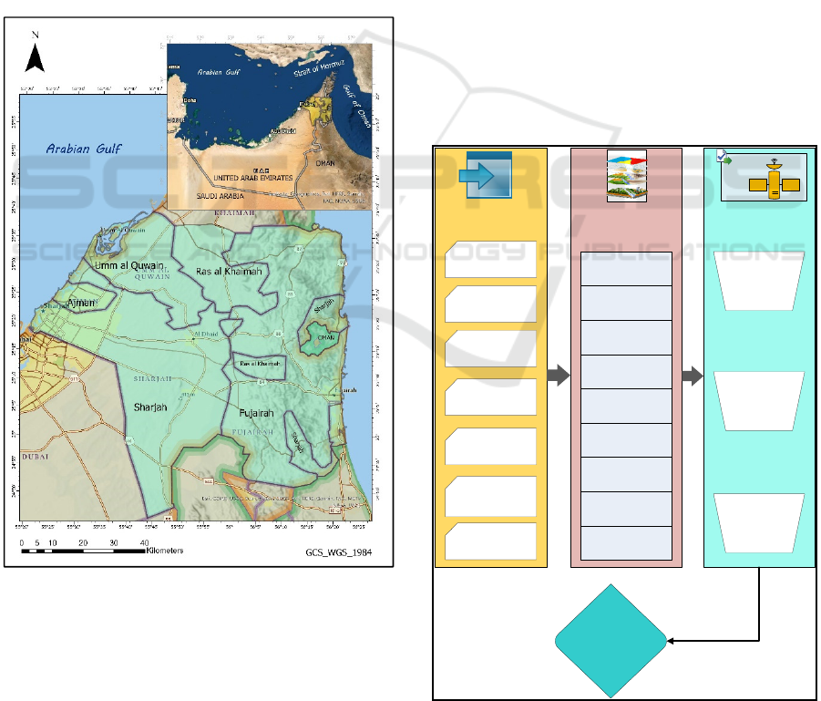
2 STUDY AREA
UAE lies in the south-eastern part of the Arabian
Peninsula bordering the Gulf of Oman and Saudi
Arabia, Figure 1 (Al-Ruzouq, Shanableh, Yilmaz, et
al., 2019; Al-ruzouq & Shanableh, 2018; Murad et al.,
2007; Shanableh et al., 2018).
Figure 1: Study Area.
The country reserves approximately 640 billion
cubic meters (BCM) of groundwater, out of which
only 20 BCM is fresh (Al-ruzouq et al., n.d.; Al-
Ruzouq, Shanableh, Yilmaz, et al., 2019). UAE’s
aquifer system is broadly classified as northern
limestone, ophiolite, eastern gravel, western gravel,
sand dune, and coastal marshes (Saif & Matri, 2008).
Among these categories of aquifer systems, sand
dune aquifer holds the major land. The Northern
Emirates shares the fairly equal proportions of all the
aquifers classes comprising coastal marshes in the
western border of the country covering cities like
Ajman and fewer portions of Sharjah and Emirate of
Umm al Quwain. The Eastern border of the country
comprises eastern gravel adjacent to the Gulf of
Oman. UAE receives approximately the mean annual
precipitation of 102mm with higher rainfall in the
mountainous region in the eastern part of the country
(Al-ruzouq et al., n.d.; Al-Ruzouq, Shanableh,
Yilmaz, et al., 2019; Sherif et al., 2018).
3 METHODS AND DATA
PROCESSING
The developed methodology for demarcating
potential zones for AGR has been illustrated in Figure
2. Historical records of climate data and suitable
remote sensing imageries were used to prepare
desired thematic layers contributing to AGR map.
Groundwater
Level (In-situ)
Groundwater
salinity (Historical
Records)
Residential
Shapefiles
Landsat 8
DEM
Annual Rainfall
(In-situ)
Precipitation
Drainage Density
Elevation
Geomorphology
Geology
GWL map
TDS Map
Lineament Density
Res. Euclidean
THEMATIC LAYERS
Landsat ETM+
Consistency
Ratio
Analytical
Hierarchical
Process
Weighting and
Ranking
AGR Potential
Zones
DATA SOURCE
MODELING AND
MAPPING
Figure 2: Methodology Framework.
GISTAM 2021 - 7th International Conference on Geographical Information Systems Theory, Applications and Management
256

Precipitation, DSD, geomorphology, geology,
groundwater level, TDS, elevation, lineament
density, euclidean distance from residential areas
were developed as thematic layers. These layers were
then processed to map the potential sites for AGR.
The layers were reclassified up to 5 classes from 1 to
9 to attain the standardization applying the natural
breaks technique. AHP approach was considered to
determine the weighting of the layers.
3.1 Thematic Layers Preparation
AGR potential zones were determined using GIS
methodologies in this research. The study considered
several factors for delineating suitable sites for AGR:
Precipitation, DSD, geomorphology, geology,
groundwater level, TDS, elevation, lineament
density, euclidean distance from residential areas
(Alrehaili & Hussein, 2012; Chowdary, 2010; Rais &
Javed, 2014). A brief description of these parameters
are discussed below:
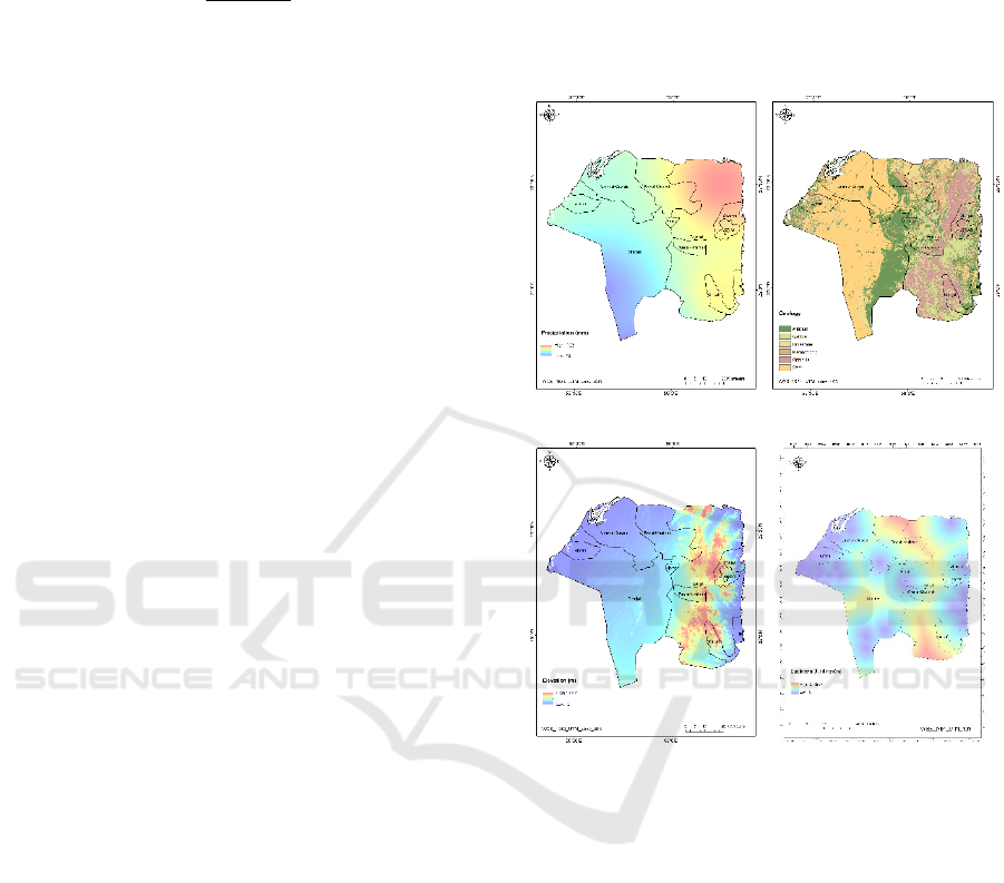
3.1.1 Precipitation
To develop the precipitation layer, UAE’s National
Centre for Meteorology was referred to procure the
annual total rainfall data for the period of 2003-2017,
Figure 3(a). The least average of annual total rainfall
was recorded as 75mm for the study area and ranged
maximum up to 103mm. Higher the rainfall values in
a region higher the suitability of AGR. Regions
receiving higher rainfall in the study area are
considered to be suitable for AGR zonation as more
amount of water is available to be stored artificially
(Al-ruzouq et al., n.d.; Al-Ruzouq, Shanableh,
Yilmaz, et al., 2019; Sherif et al., 2018).
3.1.2 Drainage Stream Density
DSD is a measure of the quantity of water drained by
the stream channels in a watershed. It is obtained via
dividing the overall stream length by the drainage
basin’s overall area. DSD is inversely proportional to
watershed permeability (Khan et al., 2020; Rais &
Javed, 2014). Therefore, DSD is a crucial parameter
to determine the suitability of the AGR. DSD is
higher in the eastern part of the Sharjah Emirate and
northern part and northeastern part of Ras-al-
Khaimah Emirate and Umm-al-Quwain, respectively
(Al-ruzouq et al., n.d.; Al-Ruzouq, Shanableh,
Yilmaz, et al., 2019). The thematic layer was
extracted from the STRTM DEM (Al-ruzouq et al.,
n.d.; Al-Ruzouq, Shanableh, Yilmaz, et al., 2019).
3.1.3 Geomorphology
Geomorphology of the Central - Northern Emirates
has been broadly classified as high and low dunes,
sand, fan deposits, mountain, urban areas, and
vegetation (Al-ruzouq et al., n.d.; Al-Ruzouq,
Shanableh, Yilmaz, et al., 2019). It helps to determine
the natural water movement at the sub-surface level
also helps to understand the possibility of the water
holding and water existence. The development of
various landforms can help in knowing about the
porous and permeable zones (Khan et al., 2020;
Senanayake et al., 2016). Fan deposits are considered
to be most favorable for AGR in the UAE. Therefore
highest rank has been assigned to fan deposits. As the
majority of the country is covered with desert sand,
high dunes also come in a higher ranking with respect
to AGR determination. This layer was prepared from
Landsat 8 ETM + satellite imagery at 30m resolution
(Al-ruzouq et al., n.d.).
3.1.4 Geology
The geology of the study area comprises alluvium,
limestone, gabbro, metamorphic, sand and ophiolite,
refer to Figure 3(b) (Al-ruzouq et al., n.d.; Al-
Ruzouq, Shanableh, Yilmaz, et al., 2019). Induced or
original effective porosity can control the recharging
capacity by allocating space to hold water (Khan et
al., 2020; Senanayake et al., 2016). Alluvium has the
highest water retention capacity, which makes it most
suitable for AGR zonation, thereby owing to higher
rank while reclassifying the thematic layer.
3.1.5 Groundwater Level
The hydraulic gradient of a particular area can be
determined by analyzing the water level which is
dependent on the pore pressure and atmospheric
pressure at the surface (Alrehaili & Hussein, 2012;
Hammouri et al., 2014; Khan et al., 2020). In-situ data
of groundwater level have been compiled, and inverse
distance weighting (IDW) interpolation technique has
been used to derive the groundwater level map. The
values are depicted in meters above sea level (masl).
GWL is inversely proportional to the AGR zonation
(Hammouri et al., 2014; Khan et al., 2020). The study
area holds higher groundwater levels in the
southeastern part of Sharjah and western part of Ras-
al-Khaimah. The reason for higher GWL in these
areas as it lies in the foothills of the mountainous
region, thereby proportionately receiving more
rainfall contributing to GWL. The IDW equation is as
follows (Agarwal & Garg, 2016; Al-Ruzouq,
Multicriteria Spatial Analysis to Map Artificial Groundwater Recharge Zones: Northern UAE
257
Shanableh, Yilmaz, et al., 2019; Chandramohan et al.,
2017):
Z
o
=
∑
∑
(1)
Where Z is the estimated value of Z at o,
z
i
is the observed value at sample point i,
d
i
is the distance between sample point i and o,
N is the number of sample points used to estimate
the value at o.
n is a distance decay parameter (da Costa et al.,
2019; Rukundo & Doğan, 2019).
3.1.6 Total Dissolved Solids
Water quality is affected by TDS. As the TDS value
increases, the turbidity also increases, and the water
becomes unsuitable for drinking and household
purpose. When water with a high level of turbidity
permeates to an aquifer, it corrupts the aquifer,
neighboring aquifers, and the whole water network by
giving rise to pathogens. Hence, lower TDS values
are preferable for AGR zonation (Kazakis, 2018;
Nasiri et al., 2013). TDS values are more in the
proximity of the shorelines of the study area. The
Gulf of Oman surrounds the eastern region of the
study area and has a salinity of 38,000 mg/L as
compared to the western region, which is surrounded
by the Arabian Gulf and has a salinity of 50,000
mg/L. Salinity values are higher in the Arabian Gulf,
resulting in higher TDS values in the western
shoreline. The map was generated using TDS values
published by the Ministry of Environment and Water,
UAE (2015).
3.1.7 Elevation
The elevation is in an inverse relationship with AGR
zonation. Lower elevation values are more suitable
for AGR (Alrehaili & Hussein, 2012; da Costa et al.,
2019; Mahmoud et al., 2014; Rahimi et al., 2014;
Sharma, 2013). The thematic layer was developed
from the SRTM DEM of 30m resolution. DEM
predicts water accumulation and movements. The
elevation ranged from 0 to 1112 m (above sea level)
in the study area, Figure 3(c). The mountainous
regions covering the parts of Fujairah and Ras-al-
Khaimah holds the highest elevation range of above
1000 masl.
3.1.8 Lineament Density
Lineament density (LD) is useful in governing
groundwater availability or the possibility of
artificially constructing an aquifer and injecting water
into it for storage. Higher LD is more suitable for
AGR zonation. It also helps in understanding high
secondary porosity in an area. A region of around
300m near a lineament is generally considered to be
a suitable area for groundwater recharge (Senanayake
et al., 2016).
(a) (b)
(c)
(d)
Figure 3: Samples for thematic layers.
3.1.9 Residential Euclidean Distance
AGR zonation for sustainable development also
depends on the factor that at what distance it is from
the residences (da Costa et al., 2019; Riad et al.,
2011). AGR cannot be designed at the heart of the
residential areas as it would disturb the environment
of the residences and humankind. Therefore, a
sustainable AGR project is considered to be designed
far from the residential areas. Euclidean distance
from the residential feature layer was calculated to
develop the thematic layer, Figure 3(d). The higher
the distance from the residential areas with the close
proximity of pipeline conveyance were considered to
be more suitable for AGR zonation (Riad et al.,
2011).
GISTAM 2021 - 7th International Conference on Geographical Information Systems Theory, Applications and Management
258

3.2 Analytical Hierarchical Process
AHP is an important multi-criteria decision making
(MCDM) aid. AHP has been used by researchers in
various groundwater studies and site selection studies
(Agarwal & Garg, 2016; Ahmadi et al., 2017; Al-
ruzouq et al., n.d.; Al-Ruzouq, Shanableh, Yilmaz, et
al., 2019; Chenini et al., 2010; Mahdavi et al., 2013;
Rahman et al., 2012; Riad et al., 2011). This study
utilizes AHP for selecting potential zones for the
AGR. An important step in AHP is prioritizing the
parameters and assigning them weights, as discussed
below.
3.2.1 Weighting the Parameters
The weights of the all the 9 selected parameters, refer
Table 1, were placed in a square matrix keeping all
the diagonal values as 1. The relative importance of
the parameters were analyzed using the principal
eigenvalue along with the normalized right
eigenvector of the matrix (Al-ruzouq et al., n.d.; Al-
Ruzouq, Shanableh, Yilmaz, et al., 2019; Chezgi et
al., 2016; Norouzi & Shahmohammadi-Kalalagh,
2019).
In addition to literature review and expertise
survey, the pairwise comparison matrix were formed
to confirm the consistency of the weights
(Chandramohan et al., 2017; Kaliraj et al., 2013;
Kazakis, 2018; Riad et al., 2011; Rukundo & Doğan,
2019; Sub et al., 2015; Yeh et al., 2016).
Measurements of consistency were done by checking
the randomized and consistency index as well as the
consistency ratio.
Table 1: Weighting for thematic layers.
THEMATIC LAYER THEMATIC LAYER
WEIGHT
Precipitation 10%
Drainage Stream Density 10%
Geomorphology 20%
Geology 20%
TDS 10%
Groundwater Level 10%
Elevation 5%
Lineament Density 5%
Residential Euclidean
Distance (m)
10%
3.2.2 Consistency Ratio
In order to confirm the consistency of the pairwise
comparison matrix, consistency index (CI),
consistency ratio (CR) and randomized index (RI)
were obtained. CR is defined as the degree of
consistency of the comparison matrix prepared with
respect to parameters and its weights. The value of
CR must be less than 0.01 for the consistency of the
matrix to be maintained (Al-ruzouq et al., n.d.; Al-
Ruzouq, Shanableh, Yilmaz, et al., 2019; Norouzi &
Shahmohammadi-Kalalagh, 2019). The CR can be
derived using the following equations:
CI =
–
(2)
RI =
. ×()
(3)
CR =
CI
RI
(4)
CI is a consistency index, RI is a randomized
index (average of CI values of the comparison
matrix), CR is a consistency ratio, λ
max
is the
maximum eigenvalue of a comparison matrix and n is
the order of the comparison matrix. The calculated
CR equals.007< .01, which supports the weighting
model and the AHP technique (Al-Ruzouq,
Shanableh, Merabtene, et al., 2019; Al-Ruzouq,
Shanableh, Yilmaz, et al., 2019).
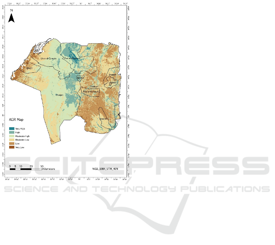
4 RESULTS AND CONCLUSION
Figure 4 represents the AGR map prepared using
AHP technique and weighted overlay tool in ArcGIS
Pro. The output map was categorized into 6 classes:
very high, high, moderate-high, moderate-low, low,
very low. The very high suitable area is mostly
concentrated in the central part of Ras al Khaimah.
The higher zones can be seen in the eastern part of
Sharjah and also the central and northern parts of Ras
al Khaimah. These regions have mostly alluvium
geology and fan deposits geomorphology. Also, the
region receives a higher amount of precipitation due
to the mountains. Arabian Gulf borders the western
part of the study area and has higher TDS values.
Also, due to densely populated regions in this area,
the region falls under low suitability for AGR
potential zones.
Demarcating suitable potential zones for AGR is
a tactical dynamism for semi-arid and arid countries.
This study combines remote sensing images, AHP,
weighting and ranking, and weighted overlay to
procure an AGR map. To derive the AGR map
precipitation, geology, geomorphology, drainage
density, lineament density, groundwater level, TDS,
euclidean distance from residential areas and
elevation were considered. Geology and
geomorphology are the foremost demanding factors.
Multicriteria Spatial Analysis to Map Artificial Groundwater Recharge Zones: Northern UAE
259
The outcome of this study furnish a suggestion for
scientific scholar community in identifying suitable
potential zones for artificial groundwater recharging.
Figure 4: AGR Map.
5 FUNDING
The project is jointly funded by the University of
Sharjah (UoS) and the Sharjah Electricity, Water, and
Gas Authority (SEWA) under the grant number:
1902041134-P.
ACKNOWLEDGEMENTS
The authors would like to thank Prof. Hamid Al
Naimy, Chancellor of UoS, and the Director of
SEWA, for facilitating the study.
REFERENCES
Agarwal, R., & Garg, P. K. (2016). Remote Sensing and
GIS Based Groundwater Potential & Recharge Zones
Mapping Using Multi-Criteria Decision Making
Technique. Water Resources Management, 30(1), 243–
260. https://doi.org/10.1007/s11269-015-1159-8
Ahmadi, M. M., Mahdavirad, H., & Bakhtiari, B. (2017).
Multi-criteria analysis of site selection for groundwater
recharge with treated municipal wastewater. Water
Science and Technology, 76(4), 909–919.
https://doi.org/10.2166/wst.2017.273
Al-Othman, A. A. (2011). Enhancing groundwater recharge
in arid region- a case study from central Saudi Arabia.
Scientific Research and Essays, 6(13), 2757–2762.
https://doi.org/10.5897/SRE11.173
Al-ruzouq, R., & Shanableh, A. (2018). Macro and micro
geo-spatial environment consideration for landfill site
selection in Sharjah , United Arab Emirates. 1–15.
Al-ruzouq, R., Shanableh, A., Merabtene, T., Siddique, M.,
& Ali, M. (n.d.). Potential Groundwater Zone Mapping
Based on Geo-Hydrological Considerations and Multi-
Criteria Spatial Analysis : North UAE. 1–40.
Al-Ruzouq, R., Shanableh, A., Merabtene, T., Siddique,
M., Khalil, M. A., Idris, A. E., & Almulla, E. (2019).
Potential groundwater zone mapping based on geo-
hydrological considerations and multi-criteria spatial
analysis: North UAE. Catena, 173(September 2018),
511–524. https://doi.org/10.1016/j.catena.2018.10.037
Al-Ruzouq, R., Shanableh, A., Yilmaz, A. G., Idris, A. E.,
Mukherjee, S., Khalil, M. A., & Gibril, M. B. A. (2019).
Dam site suitability mapping and analysis using an
integrated GIS and machine learning approach. Water
(Switzerland), 11(9). https://doi.org/10.3390/
w11091880
Alrehaili, A. M., & Hussein, M. T. (2012). Use of remote
sensing, gis and groundwater monitoring to estimate
artificial groundwater recharge in riyadh, saudi arabia.
Arabian Journal of Geosciences, 5(6), 1367–1377.
https://doi.org/10.1007/s12517-011-0306-7
Bhuiyan, C. (2015). An approach towards site selection for
water banking in unconfined aquifers through artificial
recharge. Journal of Hydrology, 523(January), 465–
474. https://doi.org/10.1016/j.jhydrol.2015.01.052
Bhunia, G. S. (2020). An approach to demarcate
groundwater recharge potential zone using geospatial
technology. Applied Water Science, 10(6), 1–12.
https://doi.org/10.1007/s13201-020-01231-1
Chandramohan, R., Vignesh, N. S., & Krishnamoorthy, R.
(2017). Remote Sensing and Gis based Approach For
Delineation of Artificial Recharge Sites In Palani
Taluk, Dindigul District ,. 8(8), 698–706.
Chenini, I., Mammou, A. Ben, & May, M. El. (2010).
Groundwater recharge zone mapping using GIS-based
multi-criteria analysis: A case study in Central Tunisia
(Maknassy Basin). Water Resources Management,
24(5), 921–939. https://doi.org/10.1007/s11269-009-
9479-1
Chezgi, J., Pourghasemi, H. R., Naghibi, S. A., Moradi, H.
R., & Kheirkhah Zarkesh, M. (2016). Assessment of a
spatial multi-criteria evaluation to site selection
underground dams in the Alborz Province, Iran.
Geocarto International, 31(6), 628–646.
https://doi.org/10.1080/10106049.2015.1073366
GISTAM 2021 - 7th International Conference on Geographical Information Systems Theory, Applications and Management
260

Chowdary, V. M. (2010). Delineation of groundwater
recharge zones and identification of artificial recharge
sites in West Medinipur district , West Bengal , using
RS , GIS and MCDM techniques. 1209–1222.
https://doi.org/10.1007/s12665-009-0110-9
da Costa, A. M., de Salis, H. H. C., Viana, J. H. M., &
Pacheco, F. A. L. (2019). Groundwater recharge
potential for sustainable water use in urban areas of the
Jequitiba River Basin, Brazil. Sustainability
(Switzerland), 11(10). https://doi.org/10.3390/su1110
2955
Dawoud, M. A. (2013). The development of integrated
water resource information management system in arid
regions. Arabian Journal of Geosciences, 6(5), 1601–
1612. https://doi.org/10.1007/s12517-011-0449-6
Farhadian, M., Bozorg-Haddad, O., Pazoki, M., &
Loáiciga, H. A. (2017). Locating and prioritizing
suitable places for the implementation of artificial
groundwater recharge plans. Journal of Irrigation and
Drainage Engineering, 143(8), 1–11. https://doi.org/
10.1061/(ASCE)IR.1943-4774.0001189
Ghayoumian, J, & Saravi, M. M. (2007). Application of GIS
techniques to determine areas most suitable for
artificial groundwater recharge in a coastal aquifer in
southern Iran. 30, 364–374. https://doi.org/10.1016/
j.jseaes.2006.11.002
Ghayoumian, Jafar, Ghermezcheshme, B., Feiznia, S., &
Noroozi, A. A. (2005). Integrating GIS and DSS for
identification of suitable areas for artificial recharge,
case study Meimeh Basin, Isfahan, Iran. In
Environmental Geology (Vol. 47, Issue 4, pp. 493–
500). https://doi.org/10.1007/s00254-004-1169-y
Hammouri, N., Al-Amoush, H., Al-Raggad, M., &
Harahsheh, S. (2014). Groundwater recharge zones
mapping using GIS: A case study in Southern part of
Jordan Valley, Jordan. Arabian Journal of Geosciences,
7(7), 2815–2829. https://doi.org/10.1007/s12517-013-
0995-1
Jasrotia, A. S., Kumar, R., & Saraf, A. K. (2007).
Delineation of groundwater recharge sites using
integrated remote sensing and GIS in Jammu district,
India. International Journal of Remote Sensing, 28(22),
5019–5036. https://doi.org/10.1080/01431160701264
276
Kaliraj, S., Chandrasekar, N., & Magesh, N. S. (2013).
Identification of potential groundwater recharge zones
in Vaigai upper basin , Tamil Nadu , using GIS-based
analytical hierarchical process ( AHP ) technique.
https://doi.org/10.1007/s12517-013-0849-x
Kazakis, N. (2018). Delineation of suitable zones for the
application of Managed Aquifer Recharge (MAR) in
coastal aquifers using quantitative parameters and the
analytical hierarchy process. Water (Switzerland),
10(6). https://doi.org/10.3390/w10060804
Khan, A., Govil, H., Taloor, A. K., & Kumar, G. (2020).
Identification of artificial groundwater recharge sites in
parts of Yamuna River basin India based on Remote
Sensing and Geographical Information System.
Groundwater for Sustainable Development,
11(February), 100415. https://doi.org/10.1016/j.gsd.
2020.100415
Mahdavi, A., Tabatabaei, S. H., Mahdavi, R., & Nouri
Emamzadei, M. R. (2013). Application of digital
techniques to identify aquifer artificial recharge sites in
GIS environment. International Journal of Digital
Earth, 6(6), 589–609. https://doi.org/10.1080/
17538947.2011.638937
Mahmoud, S. H., Alazba, A. A., & T, A. M. (2014).
Identification of Potential Sites for Groundwater
Recharge Using a GIS-Based Decision Support System
in Jazan Region-Saudi Arabia. Water Resources
Management, 28(10), 3319–3340. https://doi.org/
10.1007/s11269-014-0681-4
Malekmohammadi, B. (2012). Site selection for managed
aquifer recharge using fuzzy rules : integrating
geographical information system ( GIS ) tools and
multi-criteria decision making. 1393–1405.
https://doi.org/10.1007/s10040-012-0869-8
Murad, A. A., Nuaimi, H., & Hammadi, M. (2007).
Comprehensive assessment of water resources in the
United Arab Emirates (UAE). Water Resources
Management, 21(9), 1449–1463. https://doi.org/
10.1007/s11269-006-9093-4
Nasiri, H., Boloorani, A. D., Sabokbar, H. A. F., Jafari, H.
R., Hamzeh, M., & Rafii, Y. (2013). Determining the
most suitable areas for artificial groundwater recharge
via an integrated PROMETHEE II-AHP method in GIS
environment (case study: Garabaygan Basin, Iran).
Environmental Monitoring and Assessment, 185(1),
707–718. https://doi.org/10.1007/s10661-012-2586-0
Norouzi, H., & Shahmohammadi-Kalalagh, S. (2019).
Locating groundwater artificial recharge sites using
random forest: a case study of Shabestar region, Iran.
Environmental Earth Sciences, 78(13), 1–11.
https://doi.org/10.1007/s12665-019-8381-2
Rahimi, S., Shadman Roodposhti, M., & Ali Abbaspour, R.
(2014). Using combined AHP-genetic algorithm in
artificial groundwater recharge site selection of Gareh
Bygone Plain, Iran. Environmental Earth Sciences,
72(6), 1979–1992. https://doi.org/10.1007/s12665-014-
3109-9
Rahman, M. A., Rusteberg, B., Gogu, R. C., Lobo Ferreira,
J. P., & Sauter, M. (2012). A new spatial multi-criteria
decision support tool for site selection for
implementation of managed aquifer recharge. Journal
of Environmental Management, 99, 61–75.
https://doi.org/10.1016/j.jenvman.2012.01.003
Rais, S., & Javed, A. (2014). Identification of Artificial
Recharge Sites in Manchi Basin , Eastern Rajasthan (
India ) Using Remote Sensing and GIS Techniques.
April, 162–175.
Riad, P. H. S., Billib, M., Hassan, A. A., Salam, M. A., &
El Din, M. N. (2011). Application of the overlay
weighted model and boolean logic to determine the best
locations for artificial recharge of groundwater. Journal
of Urban and Environmental Engineering, 5(2), 57–66.
https://doi.org/10.4090/juee.2011.v5n2.057066
Rukundo, E., & Doğan, A. (2019). Dominant influencing
factors of groundwater recharge spatial patterns in
Multicriteria Spatial Analysis to Map Artificial Groundwater Recharge Zones: Northern UAE
261

Ergene river catchment, Turkey. Water (Switzerland),
11(4). https://doi.org/10.3390/w11040653
Saif, A., & Matri, A. (2008). Assessment of Artificial
Groundwater Recharge in Some Wadies in UAE by
using Isotope Hydrology Techniques. March.
Selvarani, A. G., Maheswaran, G., & Elangovan, K. (2017).
Identification of Artificial Recharge Sites for Noyyal
River Basin Using GIS and Remote Sensing. Journal of
the Indian Society of Remote Sensing, 45(1), 67–77.
https://doi.org/10.1007/s12524-015-0542-5
Senanayake, I. P., Dissanayake, D. M. D. O. K.,
Mayadunna, B. B., & Weerasekera, W. L. (2016).
Geoscience Frontiers An approach to delineate
groundwater recharge potential sites in Ambalantota ,
Sri Lanka using GIS techniques. Geoscience Frontiers,
7(1), 115–124. https://doi.org/10.1016/j.gsf.2015.03.
002
Shanableh, A., Al-Ruzouq, R., Yilmaz, A. G., Siddique, M.,
Merabtene, T., & Imteaz, M. A. (2018). Effects of land
cover change on urban floods and rainwater harvesting:
A case study in Sharjah, UAE. Water (Switzerland),
10(5). https://doi.org/10.3390/w10050631
Sharma, C. S. (2013). Artificial Groundwater Recharge
Zones Mapping Using Remote Sensing and GIS : A
Case Study in Indian Punjab. 61–71. https://doi.org/
10.1007/s00267-013-0101-1
Sherif, M. M., Ebraheem, A. M., Al Mulla, M. M., &
Shetty, A. V. (2018). New system for the assessment of
annual groundwater recharge from rainfall in the United
Arab Emirates. Environmental Earth Sciences, 77(11),
0. https://doi.org/10.1007/s12665-018-7591-3
Steinel, A., Schelkes, K., Subah, A., & Himmelsbach, T.
(2016). Analyse spatiale multi-critère pour sélectionner
des sites potentiels pour la recharge d’aquifère à partir
de collecte et d’infiltration d’eau de ruissellement
dans le nord de la Jordanie. Hydrogeology Journal,
24(7), 1753–1774. https://doi.org/10.1007/s10040-016-
1427-6
Sub, S., Cauvery, B., & Nadu, T. (2015). Delineation of
Artificial Recharge Zones Using Geospatial
Techniques in Delineation of Artificial Recharge Zones
Using Geospatial Techniques In Sarabanga Sub Basin
Cauvery River , Tamil Nadu. Aquatic Procedia,
4(December), 1265–1274. https://doi.org/10.1016/
j.aqpro.2015.02.165
Vaqharfard, H., & Dashtpagerdi, M. M. (2014). Delineation
of Groundwater Recharge Sites Using GIS Case Study :
Sefied dasht. International Journal of Advanced
Biological and Biomedical Research, 2(5), 1316–1324.
https://pdfs.semanticscholar.org/1581/0e8332cd2d8d1
e7c685091e77eb33bb4bc72.pdf?_ga=2.111128133.19
28902958.1579591155-712525998.1577015844
Yeh, H., Cheng, Y., Lin, H., & Lee, C. (2016). Mapping
groundwater recharge potential zone using a GIS
approach in Hualian River, Taiwan. Sustainable
Environment Research, 26(1), 33–43.
https://doi.org/10.1016/j.serj.2015.09.005
GISTAM 2021 - 7th International Conference on Geographical Information Systems Theory, Applications and Management
262
