
An Ontological Approach to the Formation of an Excursion Route by
Heritage Objects in GIS
Andrii Honchar
1a
, Maryna Popova
2b
and Rina Novogrudska
2c
1
Educational Programs Department, National Center "Junior Academy of Sciences of Ukraine", Kyiv, Ukraine
2
Intelligent Network Tools Department, National Center "Junior Academy of Sciences of Ukraine", Kyiv, Ukraine
Keywords: Heritage Objects, 3D Models, Ontological Model, GIS, Excursion Route.
Abstract: The paper presents an ontological approach to the consolidation of heritage objects 3D models and
geoinformation systems for the virtual excursion routes formation. Given research purpose is to provide the
opportunity for free mass access to the digitized heritage of the world civilization using augmented and
virtual reality in three-dimensional space. Modern approaches and the most common software for 3D
modelling of heritage objects are analysed. Software solutions for data 3D representation and analysis in
GIS are listed. It is shown that the most suitable for practical implementation is GIS with integrated 3D
panoramas of heritage objects. An ontological approach to the consolidation of multi-format data is
described, it provides a solution to the problems of heterogeneity and interoperability of transdisciplinary
distributed information resources that describe heritage objects. An ontological model of an excursion route
is presented; its taxonomy is implemented in the form of a graph.
1 INTRODUCTION
In recent years, the process of digital society
development has led to the need for remote
communication. Various circumstances such as long
business trips or remote work of employees,
territorial distribution of jobs, active interaction with
foreign partners, training and distance learning of
staff and other unforeseen circumstances (such as
quarantine during a coronavirus pandemic) forced to
move organizations work processes to digital space
1
.
The priorities were the organization of
geographically distributed workplaces, systems,
databases and knowledge into a single environment,
high-quality visualization of information that
simplifies its perception, analysis and assimilation,
as well as ensuring functional space flexibility and
adaptability for user interaction.
The formation of the information society and
knowledge economy has enriched the modern
vocabulary with the concept of "virtuallity", which
1
3D modelling URL: https://gisinfo.ru/3d/3d_model.htm
a
https://orcid.org/0000-0001-8877-7559
b
https://orcid.org/0000-0002-0258-1713
c
https://orcid.org/0000-0002-0533-5817
came into use not only in the context of information
and communication industry and business, but also
culture and education. A clear illustration of this fact
on a global scale is the understanding of the need to
protect the accumulated in html-format global
knowledge, as well as reaching an international
consensus on the collection, preservation and
dissemination of digital documentary heritage, as
stated in the UNESCO Charter on Digital Heritage
(United Nations Educational, Scientific and Cultural
Organization, 2009). Over the past few years, access
to global information resources has undergone
qualitative changes: the world's leading heritage
objects (museums, libraries, archives, etc.) have
made the transition from a passive form of
interaction with the civilization heritage (digital
collections, electronic collections, databases, etc.) to
active, providing opportunities for virtual travel
through the centres of historical, cultural and
scientific knowledge. The latest augmented and
virtual reality technologies, interactive elements,
three-dimensional interfaces have become an
integral attribute of a modern digital heritage object.
Relatively new technology of creating virtual
routes for tours and excursions is Geographic
Information System (GIS). It was previously used
exclusively in geography, land management, civil
170
Honchar, A., Popova, M. and Novogrudska, R.
An Ontological Approach to the Formation of an Excursion Route by Heritage Objects in GIS.
DOI: 10.5220/0010406901700176
In Proceedings of the 6th International Conference on Internet of Things, Big Data and Security (IoTBDS 2021), pages 170-176
ISBN: 978-989-758-504-3
Copyright
c
2021 by SCITEPRESS – Science and Technology Publications, Lda. All rights reserved

engineering, transport infrastructure development,
urban planning of any scale, architectural design and
other areas that require storage and analysis of data
from the objects schematic location in space.
Although the basis of GIS is a digital map created in
vector or raster graphics, as well as 3D panorama
and panoramic photo, it is a graphical visualization
of spatial data about the object. GIS includes data on
the objects size and proportions, their relative
position and 3D-panoramas (objects external
characteristics in a panoramic photo).
The main and indisputable advantage of 3D-
panorama and panoramic photo over geographic
information systems is the reliability and realism of
images not only in size and proportional data, but
also in visual colour and texture. Although it is
impossible a need to create a virtual route between
heritage objects without GIS consolidation with 3D
panorama. This tandem is the most promising and
effective tool in creating a digital and at the same
time natural system for the most accurate
transmission of the most complete information about
the real object in cyberspace.
The structure of the paper is following: Section 2
shows analyses of related works and backgrounds
for the research. Section 3 gives data classification
that is used to create GIS excursion route. Section 4
depicts ontological approach to such route
formation. Section 5 presents conclusions and plans
for future research.
2 STATE OF ART AND
BACKGROUNDS
2.1 3D Modelling of a Heritage Object
Nowadays the most popular methods for creating a
3D model of a heritage object are digital panoramic
photo and video capture, including using UAVs
(Iglesias Martínez, 2019), and laser scanning (Klapa,
2017).
Ground-based laser scanning technology allows
in a short time obtaining a three-dimensional image
of the object in the form of discrete points with
spatial coordinates (x, y, z) and with qualitative
surface characteristics (light absorption, colour,
etc.). Due to the accuracy of positioning and
measurement density, it becomes possible to analyse
the object as a whole that allows most fully
reflecting it in the model. The high shooting speed
of the laser scanner (up to several thousand and even
tens of thousands of measurements per second) and
the built-in servo-drive allow reducing time of field
works and to minimize influence of the human
factor. Also an important advantage of such
technology usage is the capture of inaccessible or
inaccessible objects due to the fact that laser
scanners shoot at a considerable distance in a
reflective mode.
For heritage object 3D-modeling specialized
programs (Real Works Survey (RWS), 3Dipsos) and
software products for three-dimensional design
(Autodesk Inventor, Autodesk Civil 3D) are used.
They are designed to process laser scanning data.
This allow performing modelling in several ways,
that is very important for heritage objects, where the
density of exhibits is extremely high and many of
them are difficult to access. The laser scanning
model of a heritage object can be converted by
software into a set of drawings, sections and
sections, which are part of the standard design
documentation during construction. Thus, this model
can be used to support the research activities of
architects, historians and more.
Despite all the advantages, laser scanning
technology is expensive, and data processing
techniques are still evolving.
The process of creating a 3D model of a heritage
object with photo panoramas consists of
photographing the object, processing and composing
images, creating the final files. For high-quality
panoramic photography, it is recommended to use a
tripod and a special panoramic head, digital camera,
lens (wide-angle or Fisheye type), a trigger for the
camera (Dovgyi, 2016). Upon completion of the
photography process and creation of an equilateral
projection to form a continuous seamless panoramic
image, stitching of a series of original photographs is
performed:
• conversion of original photographs to a form
suitable for stitching (reduction to cylindrical or
spherical projection);
• own stitching (combination of identical elements
in adjacent common areas of images);
• mixing images to equalize their brightness,
• contrast and colour tone.
Today there are many commercial (Adobe
Photoshop, Pano2VR, Easypano Panoweaver,
ArcSoft Panorama Maker, Panorama Plus Starter
Edition / X4) and free or those with a free trial
(Autopano Pro / Giga, Hugin, Microsoft Image
Composite Editor) programs for creating 3D
panoramas. The most common software is the
software product PTGui (PTGui guidance, 2020),
which has a wide range of tools for creating
panoramas and has a clear interface.
An Ontological Approach to the Formation of an Excursion Route by Heritage Objects in GIS
171

The last stage of the heritage object 3D
modelling is the combination of a ready-made 3D-
panoramas series in so-called virtual tours or walks,
where the transition from one panorama to another is
carried out through hotspots placed directly on the
images as navigation elements and/or floor plan.
Pano2VR (Du, 2015) tool is most often used for this
purpose. It allows not only forming a template using
a room plan and setting the navigation logic within a
virtual tour, but also to link multimedia content
elements to active points using the developer
interface (Flash API).
The 3D model of the heritage object is the main
source of information to develop 3D GIS, which
then forms a route for a virtual tour.
2.2 3D GIS for Creating Excursion
Routes between Heritage Objects
Traditionally, GIS is designed to store and analyse
information about spatial phenomena in order to
gain knowledge about the world around us.
According to (Campbell
, 2020), the functionality of
GIS includes the collection, structuring,
manipulation, analysis and presentation of data.
Three-dimensional geographic information systems
allow viewing objects located in the area in 3D, as
they look in real life. Indeed, 3D GIS aims to
provide the same functions as 2D GIS, but,
unfortunately, there are almost no 3D systems that
can fully and autonomously provide the process of
creating and using heritage objects. Several types of
software are used simultaneously to extract and
manage the necessary information, its analysis and
presentation, including in three-dimensional form
(for example, 2D GIS, DBMS and CAD). Due to the
shortcomings of such systems in processing 3D
objects, the data is often distributed between several
systems. For example, one system is used for data
storage and the other for 3D visualization. Such
situation often arises due to problems of
inconsistency, that leads to unnecessary time, effort
and money spending to find a solution.
To date, there are several ready-made
commercial solutions that can be classified as three-
dimensional data representation and analysis
systems. A significant share of the GIS market is
occupied by such systems as: 3D Analyst with
ArcGIS (ESRI Inc.), Imagine VirtualGIS (ERDAS
Inc.), gvSIG (gvSIG Association). They offer some
functions of three-dimensional data processing.
There are also some examples of integration of
data management applications with GIS on the
example of platforms Autodesk Revit Series (Niu,
2015; Wing, 2019; Baik, 2015), Google Earth (Niu,
2015; Wing, 2019), Autodesk Infraworks (Giudice,
2014), Autodesk 360 (Sergi, 2013), Autodesk Civil
3D (Butenko, 2020), LandXplorer CityGML Viewer
(Blut, 2017), QGIS (Iadanza, 2015) and VISSIM
(Wang, 2014). Such software solutions are usually
focused on the visualization of geometry, rather than
on geodata modelling (including topology and
thematic attributes) or on the analysis of three-
dimensional geospatial and temporal data. All
analysed systems have little functionality of 3D GIS
in terms of three-dimensional structuring, three-
dimensional manipulation and three-dimensional
analysis, but most of them can effectively process
three-dimensional data in terms of three-dimensional
visualization. A fully integrated 3D GIS solution has
not yet been offered by GIS vendors.
Although our lives are in three dimensions, until
recently, commercial GIS was largely limited to
processing only two dimensions. Both relevant
hardware and software were lacking, and the reason
for this shortcoming was the insufficient and
expensive acquisition of 3D geodata. The obvious
reason for the lack of practical full-featured three-
dimensional GIS implementation is that the
transition to 3D means an even greater variety of
object types and spatial relationships, as well as very
large amounts of unstructured data. A full-featured
3D GIS must be a true 3D GIS (geographic
information and analytical system).
3 DATA CLASSIFICATION FOR
CREATING GIS EXCURSION
ROUTE BETWEEN
3D-MODELS OF HERITAGE
OBJECTS
The initial data for the integration of heritage object
three-dimensional model, modelling of its
environment on the ground, and development of the
route for the tour are:
• vector map - a set of descriptions of passport
data about the map sheet (scale, projection,
coordinate system, rectangular and geodetic
coordinates of the sheet corners, etc.), metric
data of map objects (coordinates of objects on
the ground) and semantic data of map objects
(different properties of objects);
• height matrix that contains the absolute heights
of the terrain where the heritage objects are
located;
IoTBDS 2021 - 6th International Conference on Internet of Things, Big Data and Security
172

• triangulation relief model containing triangles of
an irregular network describing the terrain
surface;
• map classifier - a set of descriptions of vector
map layers, types of objects and their symbols,
types of semantic characteristics and their
accepted values, presented in digital form;
• library of objects three-dimensional models -
contain descriptions of the three-dimensional
type of objects.
• digital terrain photographs and digital objects
photographs.
While displaying interiors three-dimensional models
there can be used individual objects and entire
interiors, created in various programs for editing
three-dimensional images and imported into the
library of three-dimensional images of the classifier
vector map GIS (Pierdicca, 2019; Fortino, 2016;
Chianese, 2014.).
Three-dimensional visualization in 3D GIS
requires appropriate three-dimensional spatial
analysis tools. They allow easily moving between
large models in real time. Studies of the demand for
3D GIS, in particular 3D City, demonstrate the
advantage of users' choice in favour of photo-
texturing, which causes the need to store additional
data (values of model parameters) to overlay on the
geometry. Therefore, the most suitable for practical
implementation in terms of attracting time, labour
and financial resources is an integrated GIS with 3D
modelling of the heritage object from photo
panoramas.
4 ONTOLOGICAL APPROACH
TO THE FORMATION OF THE
EXCURSION ROUTE IN GIS
GIS, in the sense of integrating semantic and
geometric data, as well as spatial relationships,
seems to be the most suitable system for analysing
large amounts of data and thus for servicing many
applications and routines. Therefore, developers
working with spatial or semantic information have
been trying to achieve GIS functionality for many
years. CAD developers (such as Autodesk, Bentley)
create tools for linking two-dimensional and three-
dimensional geometry with semantic data and the
organization of topologically structured layers.
DBMS developers (Oracle, Informix) introduce
spatial descriptors to represent geometric data and
support them together with semantic data. The
consensus on how to present, provide access and
organize the dissemination of spatial information are
the OpenGIS specifications (Geospatial Information
and Standards, 2020), that allow directing the efforts
of software developers and researchers from
different fields of knowledge in one direction - the
development of functional GIS. As a result, the role
of the DBMS is changing, it should become a geo-
DBMS - an integrated "container" of semantic and
geometric properties of real objects, that will
provide functionality for storage, retrieval and
analysis of spatial data.
There is a considerable amount of researches on
the three-dimensional data structuring, but they all
are centered on several basic ideas. Each of the
proposed data structures demonstrates the
effectiveness and shortcomings in relation to
specific programs and operations that need to be
performed. However, to ensure the full functionality
of 3D GIS the issues of three-dimensional buffering,
the shortest three-dimensional route and three-
dimensional interdependence must be solved. The
integration of object-oriented approaches with 3D
GIS shifts research emphasis from standard
descriptors of objects and operations towards
databases.
Thus, when creating a virtual tour route, a
necessary step is to add its characteristics to the
simulated heritage objects, and, consequently, to
create a database. With the help of modern software
solutions on the three-dimensional model, it is
possible to create the required number of active
zones, which are used to navigate hyperlinks to
distributed information resources (databases,
electronic systems, text, spreadsheet, multimedia
content, etc.) or query the internal database where
stored information about instances (exhibits) of the
heritage object. However, this way of providing
access to information resources is accompanied not
only by organizational difficulties (time, labour and
financial costs), because there is always a risk of
information loss due to changes in the virtual
address of the information resource, but also
requires to solve number of problems such as
heterogeneity and interoperability of
transdisciplinary information resources. Database
usage allows reading, entering, modifying and
deleting data quickly and efficiently. But when
creating a route for a virtual tour, it is in need to
ensure the aggregation, integration and consistency
of information resources included in 3D models of
storage objects created in different formats
according to different standards and technologies.
Computer ontologies are promising solution for
various data sources integration that solve problems
An Ontological Approach to the Formation of an Excursion Route by Heritage Objects in GIS
173
of data structural and semantic heterogeneity, their
interoperability, elimination of inconsistencies and
uncertainties, etc. Nowadays, ontologies are an
essential element of many applications, used in
agent systems, knowledge management systems, e-
commerce, robotics, telecommunications, and
medicine. The formation of a virtual tour as a system
of knowledge about the heritage objects that is
presented in the form of integrated distributed
information content is most effectively implemented
on the basis of ontology as a semantic model of the
subject area. Ontology can also serve as an effective
tool for finding and aggregating information from
heterogeneous sources, presentation and
interpretation of transdisciplinary information in the
research process (Dovgyi, 2013; Stryzhak, 2014;
Globa, 2018).
The ontological approach to the formation of
tour route in GIS provides communication between:
systems (GIS and 3D-panorama); users and systems
(acting as a "single window" of access to
semantically related contexts of information
resources); and users with each other (defining
common vocabulary of virtual tour users who need
to interact with the information). The structure of
ontology allows displaying the specific tasks of the
integrated information environment and provides
opportunities for their solution in the ontograph
environment when necessary analytical tools are
disabled in the environment of the geoinformation
system (Popova, 2013).
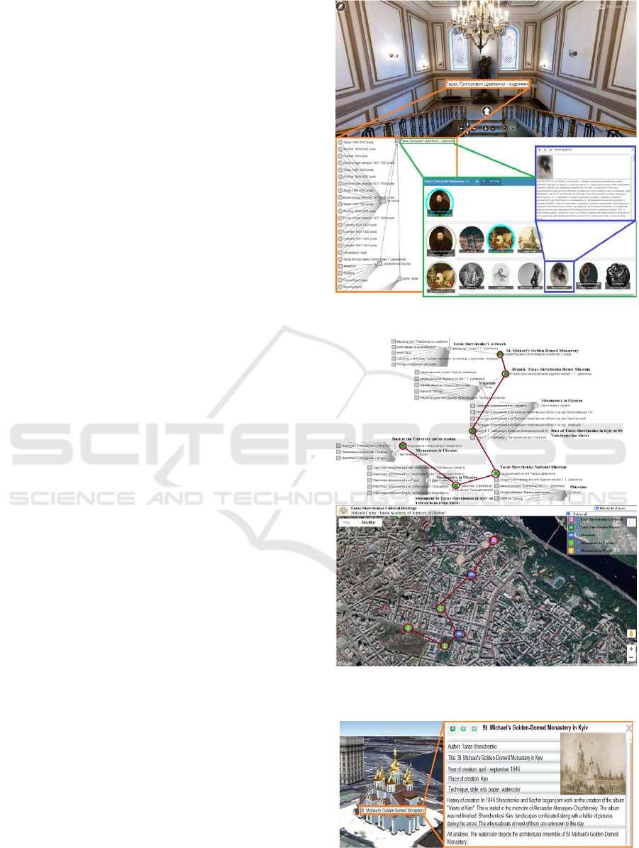
The algorithm for forming a tour route includes
the following steps:
1. Creation of heritage objects 3D models with
photo panoramas.
2. Formation of heritage objects ontology and its
integration into the created 3D-models (Figure
1).
3. Creation of 3D GIS for integration of heritage
objects ontomodels.
4. Formation of an ontological excursion route
(Figure 2).
5. Synchronization of the ontological excursion
route with 3D GIS (Figure 3).
Information modelling of heritage objects is an
information technology for displaying real objects
with virtual elements of their description. The
combination of 3D-panoramas and GIS provides the
necessary know-how to build a reliable model,
method and technology of knowledge management
about the heritage of world civilization.
The infographic model of the ontological
excursion route can be formally represented as:
𝑂
=
{
𝑋,𝑅,𝐷
,𝐷
}
(1)
Figure 1: Integration of ontology and 3D panorama.
Figure 2: Formation of an ontological excursion route and
its synchronization with 3D GIS.
Figure 3: Consolidation of excursion route fragment
(heritage object ontological 3D-model) with 3D GIS.
IoTBDS 2021 - 6th International Conference on Internet of Things, Big Data and Security
174

X – is the set of heritage objects included in the
route 𝑋={𝑋
,𝑋
,𝑋
,…,𝑋
},
where X
M
– set of museums: (𝑥
,…,𝑥
)∈
𝑋
|𝑋
⊂𝑋
X
L
– set of libraries: (𝑥
,…,𝑥
)∈𝑋
|𝑋
⊂𝑋
X
A
– set of archives: (𝑥
,…,𝑥
)∈𝑋
|𝑋
⊂𝑋.
X
obj
– set of other defined objects
(𝑥
,…,𝑥
)∈𝑋
|𝑋
⊂𝑋.
R – set of relations between heritage objects that
determine the direction and sequence of inclusion in
the route.
𝑅={𝑅
,𝑅
,𝑅
,…,𝑅
}}
(2)
D
o
– set of ontological descriptions of the steps from
which the route is formed.
D
GIS
– set of actions descriptions that are
performed in GIS to synchronize the display of the
ontological tour route
The basis of the ontology of the excursion route
is a taxonomy represented by a set of bipartite
graphs G: 𝐺=(𝑁,𝐸). Here the vertices are names
of heritage objects – N, (𝑁
,…,𝑁
)∈
𝑁
|𝑁
⊂𝑁, grouped into classes (according to
the type of heritage object - museum, library,
archive, etc.); and arcs are represented by semantic
relations between classes, based on them objects are
grouped into classes by their properties:
(𝐺
,𝐺
,𝐺
…,𝐺
)∈𝐺
}
(3)
Since in real life the tour route is not homogeneous -
one that includes heritage objects of only one type
(for example, only museums dedicated to the life
and work of Taras Shevchenko), a dynamic
redistribution of objects is provided during the tour
(for example, tour depicted in Figure 2 includes: a
bust of Taras Shevchenko at the metro station
University (1) - a Shevchenko monument at
Tereshchenkovskaya Street (2) - National Museum
of Taras Shevchenko (3) - a bust of Taras
Shevchenko on the facade of the National Academic
Opera and Ballet Theater of Ukraine (4) - Taras
Shevchenko Literary Memorial House-Museum (5) -
St. Michael's Golden-Domed Monastery in Kyiv,
depicted in watercolour by Taras Shevchenko in
1846 (6)), that can lead to the formation of new
classes of taxonomic objects (Gonchar, 2019):
𝐺
𝐺
=
{
𝐺(𝑁,𝐸)|𝑁
⊆𝑁,𝑁
⊆𝑁,
𝐸
⊆𝐸,𝐸
⊆𝐸} (4)
𝑁
⋂ 𝑁
=
{
𝑁|𝑁 ∈ 𝑁
,𝑁∈𝑁
}
}
(5)
The process of tour route forming in taxonomy
environment is reduced to solving the problem of
salesman on the graph with further displaying in GIS
environment.
5 CONCLUSIONS
Consolidation of geographic information systems
with 3D-panorama create an innovative tool for the
formation of excursion routes by virtual museums,
that provide new opportunities in the study of world
cultural, historical, scientific and digital
documentary heritage.
The ontological approach to the formation of the
tour route that was proposed in the research is
universal. It takes into account the features of the
knowledge field, the representation of which is the
heritage object through transdisciplinary integration
of distributed information resources that describe
ontological model of the selected object. Proposed
approach automated the formation of the tour route
and its components (virtual tours of individual
heritage objects) by creating ontological descriptions
of each step.
Usage of described approach for tour route
formation allowed automating its display in GIS,
which is a distinctive feature of real-time systems,
because depending on the available data the most
optimal route can be selected for the shortest period.
Ontology usage as information model of heritage
object made it possible to automate the formation of
the educational and research environment, which
best corresponds to researcher’s level of training and
his scientific profile.
Further researches would be devoted to a more
detailed consideration of the excursion routes
automated generation from sets of ontological three-
dimensional models, as well as to the software
implementation of the proposed approach.
REFERENCES
United Nations Educational, Scientific and Cultural
Organization. Charter on the Preservation of the
Digital Heritage URL: https://unesdoc.unesco.org/ark:/
48223/pf0000179529.page=2 (Accessed 6.11.2020)
Iglesias Martínez, L., De Santos-Berbel, C, Pascual, V.,
Castro, M., 2019. Using Small Unmanned Aerial
Vehicle in 3D Modeling of Highways with Tree-
Covered Roadsides to Estimate Sight Distance. In:
Remote Sensing, 2625, 1-13. doi:
10.3390/rs11222625.7
Klapa, P., Mitka, B., Zygmunt, M., 2017. Application of
Integrated Photogrammetric and Terrestrial Laser
Scanning Data to Cultural Heritage Surveying. In: IOP
An Ontological Approach to the Formation of an Excursion Route by Heritage Objects in GIS
175

Conference Series: Earth and Environmental Science,
95(3), 032007, 1-8. doi:10.1088/1755-
1315/95/3/032007.
Dovgyi, S.O., Stryzhak, O.Ye., Andrushchenko, T.I., 2016.
Ontological study of the life and work of Taras
Shevchenko in the scientific and educational portal
KOBZAR.UA, Institute of the Gifted Child. Kyiv, p
175.
Create high quality panoramic images. Panorama Tools
Graphical user interface, 2010, http://www.ptgui.com
(Accessed 6.11.2020)
Du, M., Wen, Y., Feng, Y., Yao, Y., Liu, J., Du, M., Zhu,
G., 2015. A new panoramic station visulization
method of street view and its applications.
Campbell, H., Masser, I., 2020. Gis and Organizations,
CRC Press. London, p. 224. doi:
10.1201/9781003062639.
Niu, S.Y., Pan, W., Zhao, Y., 2015. A BIM-GIS integrated
web-based visualization system for low energy
building design. In Procedia Engineering, 121, 2184-
2192.
Wing, E., 2019. Working with the Autodesk Revit Tools.
In: Revit® 2020 for Architecture. doi:
10.1002/9781119560067.ch4.
Baik, A., Yaagoubi, R., Boehm, J., 2015. Integration of
Jeddah historical BIM and 3D GIS for documentation
and restoration of historical monument International
Archives of the Photogrammetry. In Remote Sensing
and Spatial Information Sciences, XL-5/W7, 29-34.
Giudice, M.D., Osello, A., Patti, E., 2014. BIM and GIS
for district modelling. In European Conference on
Product & Process Modelling (Vienna, Austria).
Sergi, M.D., Li, J., 2013. Applications of GIS-enhanced
networks of engineering information. In Applied
Mechanics & Materials, 444-445, 1672-1679.
Butenko, E., Borovyk, K., Gerin, A., Gubkin, B., 2020.
Creating a digital relief model by aerial photography
materials in Civil 3D software. In: Zemleustrìj, kadastr
ì monìtorìng zemelʹ. doi:
10.31548/zemleustriy2020.02.16.
Blut, C., Blut, T., Blankenbach, J., 2017. CityGML goes
mobile: application of large 3D CityGML models on
smartphones.In: International Journal of Digital
Earth, 12, 1-18. doi: 10.1080/17538947.2017.1404150.
Iadanza, E., et al, 2015. The STREAMER European
project. Case study: careggi hospital in Florence. In
6th European Conference of the International
Federation for Medical and Biological Engineering.
Springer International Publishing, 649-652.
Wang, J., 2014. A cooperative system of GIS and BIM for
traffic planning: a high-rise building case study,
cooperative design, visualization, and engineering. In
6th European Conference of the International
Federation for Medical and Biological Engineering.
Springer International Publishing, 143-150.
Pierdicca, R., et al., 2019. Iot and engagement in the
ubiquitous museum. In Sensors, 19(6), 1387.
Fortino, G., et al., 2016. Towards cyberphysical digital
libraries: integrating IoT smart objects into digital
libraries. In Management of Cyber Physical Objects in
the Future Internet of Things, Springer, Cham, 135-
156.
Chianese, A., Francesco P., 2014. Designing a smart
museum: When cultural heritage joins IoT. In Third
International Conference on Technologies and
Applications for Smart Cities (I-TASC ’14).
OGC. Geospatial Information and Standards. URL:
https://www.ogc.org/ (Accessed 6.11.2020)
Dovgyi, S.O., Stryzhak, O.Ye., Andrushchenko, T.I., 2013.
Computer ontologies and their use in the educational
process. Theory and practice, Institute of the Gifted
Child. Kyiv, p 310.
Stryzhak, O.Ye., 2014. Ontological aspects of
transdisciplinary integration of information resources.
In Open information and computer integrated
technologies, 65, 211-223.
Globa. L.S., Novogrudska, R.L., Koval, A.V., 2018.
Ontology Model of Telecom Operator Big Data. In
Proceedings of IEEE International Black Sea
Conference on Communication and Netwoorking
(BlackSeaCom), pp 1-5. doi:
10.1109/BlackSeaCom.2018.8433710.
Popova, M.A., 2013. Model of the ontological interface
for the aggregation of information resources and GIS
tools. In International Journal “Information
Technologies and Knowledge”, 7(4), 362-370.
Gonchar, A.V., Popova, M.A., Stryzhak, O.Ye., 2019.
Ontology of a tour of the 3D panorama of the virtual
museum. In Ecological safety and nature management,
29(1), 71-78. DOI: https://doi.org/10.32347/2411-
4049.2019.1.71-78.
IoTBDS 2021 - 6th International Conference on Internet of Things, Big Data and Security
176
