
A Landscape Photograph Localisation Method with a Genetic Algorithm
using Image Features
Hideo Nagashima and Tetsuya Suzuki
a
Graduate School of Systems Engineering and Science, Shibaura Institute of Technology, Saitama, Japan
Keywords:
Geolocation, Genetic Algorithm.
Abstract:
It improves the utility value of landscape photographs to identify their shooting locations and shooting di-
rections because geolocated photographs can be used for location-oriented search systems, verification of
historically valuable photographs and so on. However, a large amount of labor is required to perform manual
shooting location search. Therefore, we are developing a location search system for landscape photographs.
To find where and how a given landscape photograph was taken, the system puts virtual cameras in three-
dimensional terrain model and adjusts their parameters using a genetic algorithm. The system does not realize
efficient search because it has problems such as a long processing time, a multimodal problem and optimiza-
tion by genetic algorithms. In this research, we propose several efficient search methods using image features
and show experimental results for evaluation of them.
1 INTRODUCTION
In general, identifying the shooting location and
shooting direction of landscape photographs leads to
effective use of them because geolocated photographs
can be used for location-oriented search systems, ver-
ification of historically valuable photographs and so
on. However, a great deal of labor is required to man-
ually identify the shooting location.
Therefore, we worked on developing a system
which supports to identify geolocations of landscape
photographs (Suzuki and Tokuda, 2008; Suzuki and
Tokuda, 2006). The system targets landscape pho-
tographs whose shooting locations can be identified
by mountain ridges and terrain in them. It puts virtual
cameras in three-dimensional terrain model, each of
which has a latitude, a longitude, a altitude, a direc-
tion and a focal length as parameters. It then adjusts
their parameters using a genetic algorithm (GA). The
GA uses a fitness function which compares charac-
teristics of a given landscape photograph and those
of photographs taken by virtual camera parameters in
the three-dimensional terrain model.
It is difficult for the system to find good solutions
in general because the landscape of the fitness func-
tion constructed from the characteristics of a given
landscape photograph tends to be multimodal and in-
a
https://orcid.org/0000-0002-9957-8229
clude a large plateau. We could not improve the
search process enough though we introduced some
techniques to the system, which are relaxation of op-
timization problems, a local search to avoid lethal
genes and so on. In addition, much experimental
codes added to the system made it difficult to mod-
ify the system.
To introduce a more intelligent camera parameter
adjustment method based on image features, we de-
cided to abandon extension of the existing system and
implement a new system.
The organization of this paper is as follows. In
section 2, we summarize related work including our
former system. We then explain an overview of our
new system in section 3 and explain search methods
in the new system in section 4. We explain experiment
in section 5 and evaluate the results in section 6. We
state concluding remarks in section 7.
2 RELATED WORK
2.1 Our Former System
Fig.1 shows the entire search process in our former
system. To find the location of a landscape photo-
graph by our former system, we take the following
steps.
1290
Nagashima, H. and Suzuki, T.
A Landscape Photograph Localisation Method with a Genetic Algorithm using Image Features.
DOI: 10.5220/0010394712901297
In Proceedings of the 13th International Conference on Agents and Artificial Intelligence (ICAART 2021) - Volume 2, pages 1290-1297
ISBN: 978-989-758-484-8
Copyright
c
2021 by SCITEPRESS – Science and Technology Publications, Lda. All rights reserved
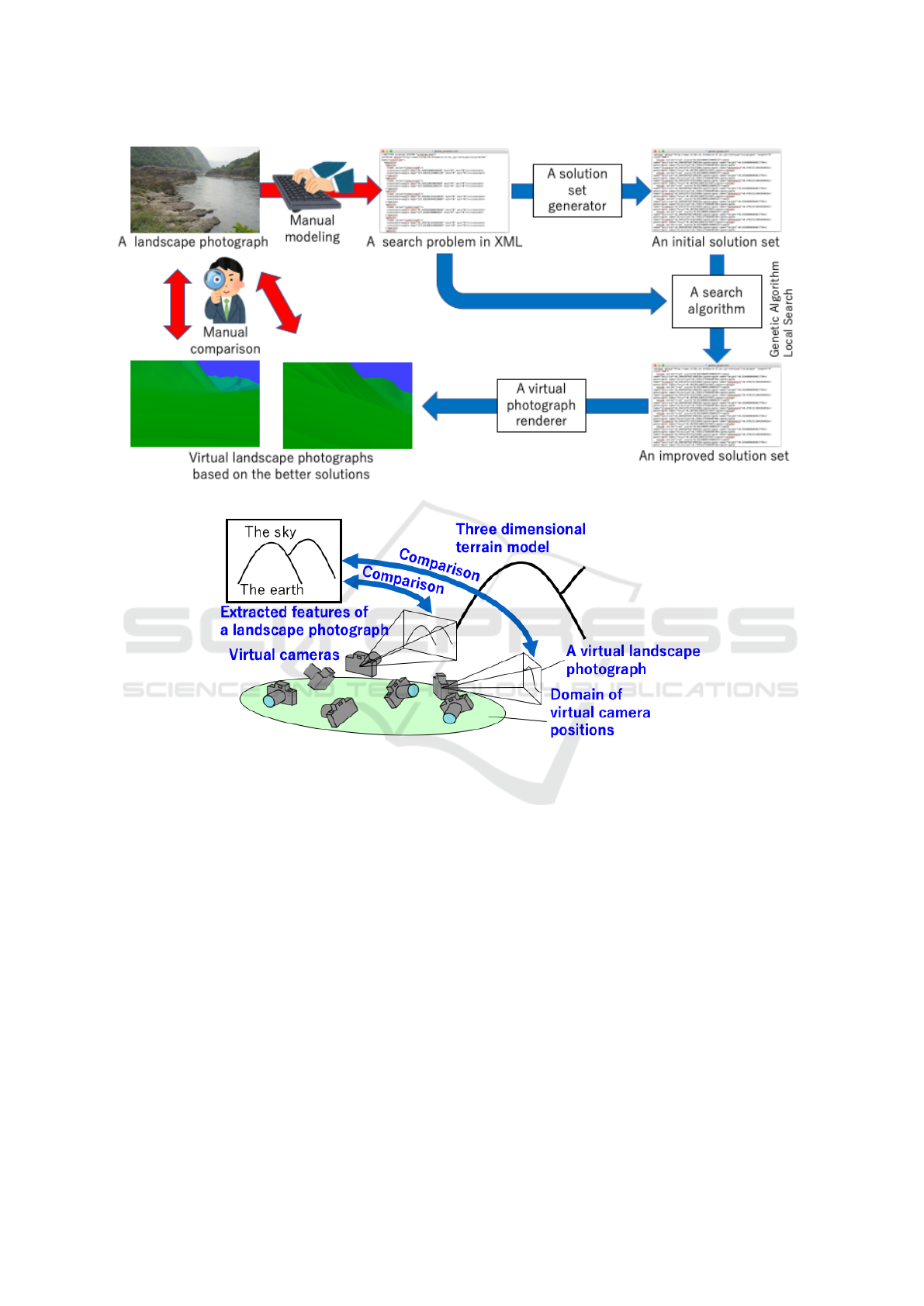
Figure 1: The entire search process using our former system.
Figure 2: Search in our former system.
1. definition of a search problem
2. generation of initial solution sets
3. search
4. check of the resulting solutions
We explain these steps in the following.
To define a search problem for our system, we
describe features of terrain in the photograph, cam-
eras settings, and a search space declaratively. For
example, shapes of mountains which are boundaries
between the earth and the sky, variables for cameras
settings and their domains.
Before we start a search, we generate an initial
solution set. The generated solution set is used as start
points of a search.
Our former system improves solutions in a given
solution set by a specified search algorithm, and out-
puts the resulting solutions. We have implemented
a real-coded genetic algorithm and a local search al-
gorithm as search algorithms for our former system.
The real-coded genetic algorithm uses unimodal nor-
mal distribution crossover (UNDX)-m as a crossover
operation and distance dependent alternation (DDA)
model as a generation alternation model. The real-
coded genetic algorithm with the combination keeps
the variety of solutions during searches (Takahashi
et al., 2000). The search algorithm refers to a data el-
evation model (DEM), which is 50m digital elevation
model of Japan published by the Geographical Survey
Institute. Fig.2 shows search by a search algorithm.
We finally take virtual photographs based on the
resulting solutions for check because better solutions
for a search problem may not be solutions we expect
if the problem definition is not adequate.
We have problems about the former system as fol-
lows.
1. Much experimental codes added to the system
makes it difficult to modify the system.
A Landscape Photograph Localisation Method with a Genetic Algorithm using Image Features
1291

2. The system is very slow in search because it in-
volves many translation between two coordinate
systems: the latitude-longitude-altitude coordi-
nate system and the geocentric Cartesian coordi-
nate system. The system uses the former for ter-
rain data and the latter for line of sight from cam-
eras, and the translation between them is needed
in collision detection between line of sight from
cameras and the earth in the terrain model.
3. We could not improve the search process enough
though we introduced some techniques to the sys-
tem, which are relaxation of optimization prob-
lems, a local search to avoid lethal genes and so
on.
2.2 A CNN-based Method
Tobians Weyand et al. proposed a method to identify
the shooting area using convolution neural network
(CNN) (Hays and Efros, 2008). It divides the world
map into multiple areas and learns areas in which
given landscape photographs were taken. When a new
landscape photograph without location information is
input, it estimates an area in which the landscape pho-
tograph was highly likely taken.
The method can narrow down the shooting area,
but cannot specify the shooting location in detail. To
specify the shooting location in detail, it is necessary
to divide the world map in more detail and use a lot
of photographs with shooting location information for
training.
3 AN OVERVIEW OF OUR NEW
SYSTEM
To resolve the problems of our former system pointed
out in section 2.1, we decided to develop a new sys-
tem which supports to identify geolocations of land-
scape photographs from scratch.
The main differences between our former system
and the our new system are as follows.
1. We changed the implementation language from
Java to Python. One of the reason is that Python
is in widespread use as Java. Another reason
is that we plan to introduce image segmentation
based on deep neural network for automatic im-
age feature extraction to define a search problem
from a given landscape photograph and Python
libraries for deep learning such as TensorFlow
(Abadi et al., 2015) and PyTorch (Paszke et al.,
2019) are also in widespread use. In addition, it
would be easy to implement a domain specific lan-
guage for search problem in Python than in Java.
2. We changed the mainly used coordination sys-
tem for terrain data from the latitude-longitude-
altitude coordinate system to the geocentric Carte-
sian coordinate system. To realize the change, we
use three dimensional polygons converted from
the DEM used in our former system as terrain
data.
3. We introduced a camera parameter adjustment
method based on image features to make parame-
ter adjustment more efficient.
4 SEARCH IN OUR SYSTEM
In this section, we explain how our new system search
the shooting location of a given landscape using a
real-coded genetic algorithm.
4.1 An Overview of the Search Process
The input for our new system are a color-coded land-
scape photograph whose colors corresponds to at-
tributes such as the sky and the ground surface, and
a search range. If the input is given, our new system
works as follows.
1. It extracts image features such as ridge lines from
the given color-coded photograph.
2. It sets the search range as a geographical area.
3. It generates an initial solution set, each solution of
which corresponds to initial parameters of a vir-
tual camera. It uses the terrain data of the geo-
graphical area to place virtual cameras where the
surrounding scenery can be looked over.
4. It repeats the following steps until the best fitness
function’s value converges or the number of repe-
tition reaches the specified number of times.
(a) For each virtual camera, it calculates the
ridge line in the virtual landscape photograph,
the color-coded virtual landscape photograph
whose colors correspond to attributes such as
the sky and the ground surface, and the depth
image of the virtual landscape photograph.
(b) For each virtual camera, it compares the fea-
tures of the input landscape photograph with
the features of the ridge line taken by the cam-
era and calculates the fitness function value of
the camera based on the degree of similarity be-
tween them. The higher the degree of similarity
is, the lower the fitness function value is.
ICAART 2021 - 13th International Conference on Agents and Artificial Intelligence
1292

(c) For each camera with a fitness function value
above a certain level, it improves the camera
parameters using the depth image.
(d) For each camera with a fitness function value
above a certain level, it adjusts the direction
of the camera to maximize the fitness function
value without changing its latitude and longi-
tude.
(e) It updates the solution set by the crossover op-
eration UNDX-m and the generation alternation
model DDA.
4.2 Evaluation Function by Image
Feature
This is the step 4(b) of our new system described in
section 4.1. It uses an image feature matching al-
gorithm AKAZE (Alcantarilla et al., 2013) to com-
pare the color-coded image of an input landscape
photograph and that of the virtual landscape photo-
graph taken by a virtual camera. AKAZE is an algo-
rithm that is resistant to scaling and rotation. It apply
smoothing filters to the images before comparison by
AKAZE. It combines AKAZE with template match-
ing, which is vulnerable to scaling, because some sim-
ilar images found by AKAZE are quite different when
compared by humans though AKAZE can find partial
matching of images.
4.3 Initial Solution Set Generation
This is the step 3 of our new system described in sec-
tion 4.1. In our former system, initial solutions are
randomly generated within the specified range. The
system initially places virtual cameras on mountains
to make it possible to overlook many ridge lines be-
cause the system uses ridge lines for comparison pho-
tographs during search.
The procedure to place cameras on mountains is
shown below. The range can be a quadrangle. It takes
the number of initial solutions and a rectangular geo-
graphical area as input.
1. It stores the elevation data of the specified geo-
graphical area into a two-dimensional array E.
2. It repeats the following steps until the number of
the extracted summit reaches the specified num-
ber of initial solutions.
(a) It finds the summit which is the highest place in
E.
(b) It records the array coordinate of the summit.
(c) It ignores the summit and the arbitrary range
around it hereafter.
3. It outputs the recorded summits as initial solu-
tions.
4.4 Improvement by Distance
Adjustment
This is the step 4(c) of our new system described in
section 4.1. Even if a mountain to be searched is in
the image taken by a virtual camera during search, our
former system can not adjust its camera parameters in
consideration of it. Our new system, however, adjusts
its camera parameters using both the depth image by
the camera as follows if the fitness value of a virtual
camera is higher than the threshold value.
1. It finds the n-best positions of image feature
matching in the image and the scale ratio of the
image.
2. It creates the depth image by the camera and a
ridge line image with the n-best positions.
3. It obtains the average distance of the ridge line by
the depth image and the ridge line image.
4. It determines the amount of camera movement
based on the distance, the amount of pixel move-
ment in the image, and the scale ratio.
4.5 Improvement by Camera Direction
Adjustment
This is the step 4(d) of our new system described in
section 4.1. The step tries to improve the fitness func-
tion value of a virtual camera by changing the direc-
tion of the camera. The procedure is as follows.
1. For each camera with a fitness function value
above a certain level, it performs the following
steps.
(a) It takes virtual landscape photographs while
horizontally rotating the camera by 10 degrees.
(b) Let d and s be the direction of a virtual land-
scape photograph among them which maxi-
mizes the degree of similarity to the given land-
scape photograph and the maximum degree of
similarity respectively.
(c) If s is greater than the degree of similarity be-
tween the given landscape photograph and the
virtual landscape photograph of the camera, it
changes the camera direction to d.
5 EXPERIMENT
We conducted a comparative experiment to verify the
effect of our new system and the the search method
A Landscape Photograph Localisation Method with a Genetic Algorithm using Image Features
1293
described in section 4.1 under the following condi-
tions.
• The search range is 20 km square around Mt. Fuji.
• The number of generations of the genetic algo-
rithm was fixed at 50 generations.
• The input image used was the image of the sum-
mit of Mt. Fuji. The image is a color-coded image
for each attribute.
• The following three methods were compared.
Baseline The initial solutions are randomly gen-
erated, and the following three methods are not
used.
Method 1 The initial solution generation method
described in section 4.3
Method 2 The improvement-by-distance-
adjustment described in section 4.4
Method 3 The improvement-by-camera-
direction-adjustment described in section
4.5
• The experiment was performed with five patterns:
the baseline, each of the method 1, 2 and 3, and
the combination of the method 1, 2 and 3.
The input image and its camera parameter are
shown in Fig.3 and Table 1 respectively. The sky and
the ground are painted in black and green respectively
in Fig.3.
The resulting images of the five patterns are shown
in Fig.4, Fig.5, Fig.6, Fig.7, and Fig.8. The sky and
the ground are painted in black and green respectively
in the figures as in Fig.3. The resulting images’ cam-
era parameters and the evaluation value are shown in
Table 2, Table 3, Table 4, Table 5, and Table 6. The
evaluation values should be low because they are the
degree of difference from the input image.
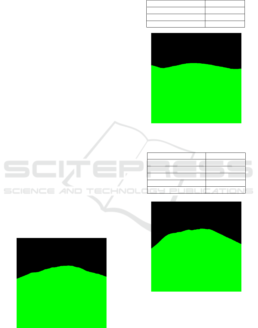
Figure 3: The input image.
Fig.9 and Fig.10 show the fitness of the optimal
solution at each generation in each method. The ini-
Table 1: The input image’s camera parameters.
Latitude (deg.) 35.39333333
Longitude (deg.) 138.81333333
Azimuth Angle (deg.) 122
Elevation Angle (deg.) 0
Figure 4: The resulting best image (the baseline).
Table 2: The resulting best image’s camera parameter (the
baseline).
Latitude (deg.) 35.37055556
Longitude (deg.) 138.84944444
Azimuth Angle (deg.) 2
Elevation Angle (deg.) 0
Distance (m) 4141.52
Evaluation Value 23.90
Figure 5: The resulting best image (the method 1).
tial fitness values in the method 1, which is the ini-
tial solution generation method described in section
4.3, and all the methods are higher than other three
methods. The fitness values of the method 1 and all
the methods are at least 86 until the 21th generation
while those of other methods are at most 24. The fit-
ness value in the method 3, which is the improvement-
ICAART 2021 - 13th International Conference on Agents and Artificial Intelligence
1294
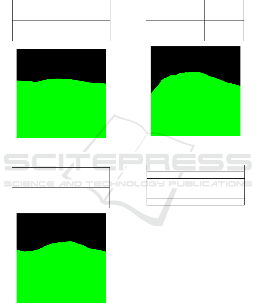
Table 3: The resulting best image’s camera parameter (the
method 1).
Latitude (deg.) 35.33305556
Longitude (deg.) 138.77111111
Azimuth Angle (deg.) -1
Elevation Angle (deg.) -16
Distance (m) 7710.35
Evaluation Value 9.70
Figure 6: The resulting best image (the method 2).
Table 4: The resulting best image’s camera parameter (the
method 2).
Latitude (deg.) 35.35638889
Longitude (deg.) 138.82666667
Azimuth Angle (deg.) 9
Elevation Angle (deg.) 0
Distance (m) 4274.21
Evaluation Value 14.09
Figure 7: The resulting best image (the method 3).
by-camera-direction-adjustment described in section
4.5, is lower than other methods from the beginning,
which is at most 19.
From the viewpoint of the fitness values, the best
Table 5: The resulting best image’s camera parameter (the
method 3).
Latitude (deg.) 35.36055555
Longitude (deg.) 138.85527777
Azimuth Angle (deg.) -37
Elevation Angle (deg.) 0
Distance (m) 5267.98
Evaluation Value 6.84
Figure 8: The resulting best image (all the methods).
Table 6: The resulting best image’s camera parameter (all
the methods).
Latitude (deg.) 35.35944444
Longitude (deg.) 138.87444444
Azimuth Angle (deg.) 88
Elevation Angle (deg.) -10
Distance (m) 6706.20
Evaluation Value 16.11
result was obtained when only the method 3, which
is the improvement-by-camera-direction-adjustment
described in section 4.5, was used. From the view-
point of the distance from the position where the in-
put image was taken, the best result was obtained in
the baseline.
6 EVALUATION
We evaluate the experimental results by Fig.9 and
Fig.10 as follows.
• Because the best fitness value of the initial solu-
tions of the method 3 was the best among those
of the methods in the experiment, we confirmed
that initial solutions can be improved well by op-
timizing the camera orientations even if they are
randomly generated.
• The fitness values of the method 1 is the worst
A Landscape Photograph Localisation Method with a Genetic Algorithm using Image Features
1295
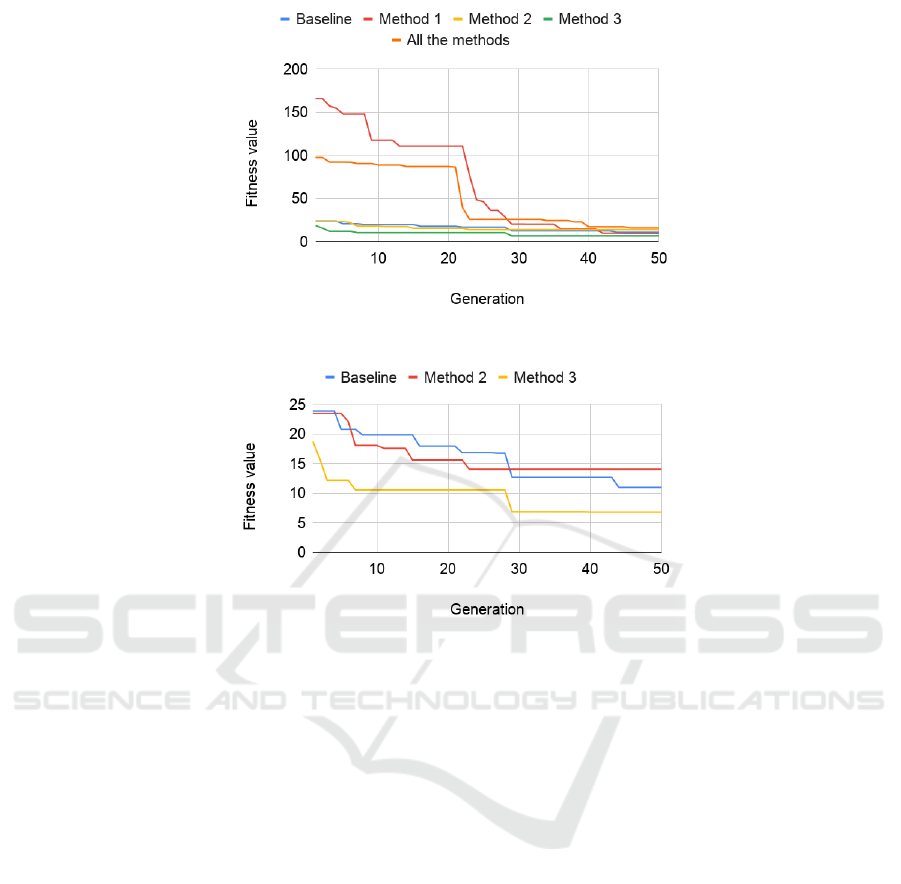
Figure 9: Fitness values of the best individuals at each generation.
Figure 10: Fitness values of the best individuals at each generation (except the method and all the method).
among those of the methods in the experiment,
and that of all the methods which includes the
method 1 is the second worst. We guess the rea-
sons as follows.
– The method 1 placed initial cameras on the
summit of the target mountain in the input im-
age because the target mountain is a single peak
mountain and no other mountains exist in the
search area. As the result, the camera can not
take pictures of the mountain.
– The diversity of initial solutions was decreased
by the method 1.
7 CONCLUSION
We proposed a new shooting location search system
and a new search method. The system targets land-
scape photographs whose shooting locations can be
identified by mountain ridges and terrain in them.
The system places virtual cameras in three dimen-
sional terrain model and searches camera parameters
which can take a landscape photograph similar to a
given landscape photograph using a real-coded ge-
netic algorithm. We conducted experiments to ver-
ify effectiveness of the proposed three camera pa-
rameter methods, and confirmed that the initial so-
lution set generation method which places cameras
on mountains and a camera parameter adjustment
method which find better direction by rotating cam-
eras are effective. We also confirmed that the fitness
function in the genetic algorithm which compares two
images is still insufficient.
Our future works are improvement of initial solu-
tion set generation, the fitness function in the genetic
algorithm, image segmentation for automatic image
feature extraction to define a search problem from a
given landscape photograph, and coping with foggy
input photographs which hide ridge lines.
REFERENCES
Abadi, M., Agarwal, A., Barham, P., Brevdo, E., Chen, Z.,
Citro, C., Corrado, G. S., Davis, A., Dean, J., Devin,
M., Ghemawat, S., Goodfellow, I., Harp, A., Irving,
G., Isard, M., Jia, Y., Jozefowicz, R., Kaiser, L., Kud-
lur, M., Levenberg, J., Man
´
e, D., Monga, R., Moore,
S., Murray, D., Olah, C., Schuster, M., Shlens, J.,
ICAART 2021 - 13th International Conference on Agents and Artificial Intelligence
1296

Steiner, B., Sutskever, I., Talwar, K., Tucker, P., Van-
houcke, V., Vasudevan, V., Vi
´
egas, F., Vinyals, O.,
Warden, P., Wattenberg, M., Wicke, M., Yu, Y., and
Zheng, X. (2015). TensorFlow: Large-scale machine
learning on heterogeneous systems. Software avail-
able from tensorflow.org.
Alcantarilla, P. F., Nuevo, J., and Bartoli, A. (2013). Fast
explicit diffusion for accelerated features in nonlinear
scale spaces. In Burghardt, T., Damen, D., Mayol-
Cuevas, W. W., and Mirmehdi, M., editors, British
Machine Vision Conference, BMVC 2013, Bristol,
UK, September 9-13, 2013. BMVA Press.
Hays, J. and Efros, A. A. (2008). Im2gps: estimating ge-
ographic information from a single image. In 2008
IEEE Conference on Computer Vision and Pattern
Recognition, pages 1–8.
Paszke, A., Gross, S., Massa, F., Lerer, A., Bradbury, J.,
Chanan, G., Killeen, T., Lin, Z., Gimelshein, N.,
Antiga, L., Desmaison, A., Kopf, A., Yang, E., De-
Vito, Z., Raison, M., Tejani, A., Chilamkurthy, S.,
Steiner, B., Fang, L., Bai, J., and Chintala, S. (2019).
Pytorch: An imperative style, high-performance deep
learning library. In Wallach, H., Larochelle, H.,
Beygelzimer, A., d’ Alch
´
e-Buc, F., Fox, E., and Gar-
nett, R., editors, Advances in Neural Information Pro-
cessing Systems 32, pages 8024–8035. Curran Asso-
ciates, Inc.
Suzuki, T. and Tokuda, T. (2006). A system for landscape
photograph localization. In Proceedings of the Sixth
International Conference on Intelligent Systems De-
sign and Applications - Volume 01, ISDA ’06, page
10801085, USA. IEEE Computer Society.
Suzuki, T. and Tokuda, T. (2008). Initial solution set im-
provement for a genetic algorithm in a metadata gen-
eration support system for landscape photographs. In
Tokunaga, T. and Ortega, A., editors, Large-Scale
Knowledge Resources. Construction and Application,
pages 67–74, Berlin, Heidelberg. Springer Berlin Hei-
delberg.
Takahashi, O., Kita, H., and Kobayashi, S. (2000). A
real-coded genetic algorithm using distance depen-
dent alternation model for complex function opti-
mization. In Proceedings of the 2nd Annual Con-
ference on Genetic and Evolutionary Computation,
GECCO’00, page 219226, San Francisco, CA, USA.
Morgan Kaufmann Publishers Inc.
A Landscape Photograph Localisation Method with a Genetic Algorithm using Image Features
1297
