OFFSED: Off-Road Semantic Segmentation Dataset
Peter Neigel
1,2
, Jason Rambach
1
and Didier Stricker
1,2
1
German Research Center for Artificial Intelligence, Kaiserslautern, Germany
2
University of Kaiserslautern, Germany
Keywords:
Semantic Segmentation, ADAS, Outdoor, Industrial Vehicles.
Abstract:
Over the last decade, improvements in neural networks have facilitated substantial advancements in automated
driver assistance systems. In order to manage navigating its surroundings reliably and autonomously, self-
driving vehicles need to be able to infer semantic information of the environment. Large parts of the research
corpus focus on private passenger cars and cargo trucks, which share the common environment of paved roads,
highways and cities. Industrial vehicles like tractors or excavators however make up a substantial share of the
total number of motorized vehicles globally while operating in fundamentally different environments. In this
paper, we present an extension to our previous Off-Road Pedestrian Detection Dataset (OPEDD) that extends
the ground truth data of 203 images to full image semantic segmentation masks which assign one of 19 classes
to every pixel. The selection of images was done in a way that captures the whole range of environments and
human poses depicted in the original dataset. In addition to pixel labels, a few selected countable classes also
come with instance identifiers. This allows for the use of the dataset in instance and panoptic segmentation
tasks.
1 INTRODUCTION
Advanced Driver Assistance Systems (ADAS) for pri-
vate passenger cars, trucks, mobile working machines
and other vehicles need to be able to navigate their
often complex environments in an intelligent man-
ner in order to provide a benefit to the human driver
while maintaining all required safety standards. To
this effect a suitable understanding of the surround-
ings is required. In computer vision terms, the sys-
tem must be able to semantically understand the con-
tent of images received by attached cameras in its
entirety: Pedestrians must be recognized to support
emergency breaks, passable ground and marked lanes
need to be understood in order to maneuver the vehi-
cle and so forth. Current state-of-the-art approaches
to semantic full image segmentation mainly rely on
convolutional neural networks that take in a monocu-
lar RGB-image as input and produce a class label for
every pixel in the image. To train these networks in
a supervised manner large image datasets are needed
that come with ground truth semantic labels for ev-
ery pixel in the image. Due to the focus of current
research on private passenger cars and cargo trucks,
most available datasets including semantic pixel la-
bels depict urban environments or highway roads.
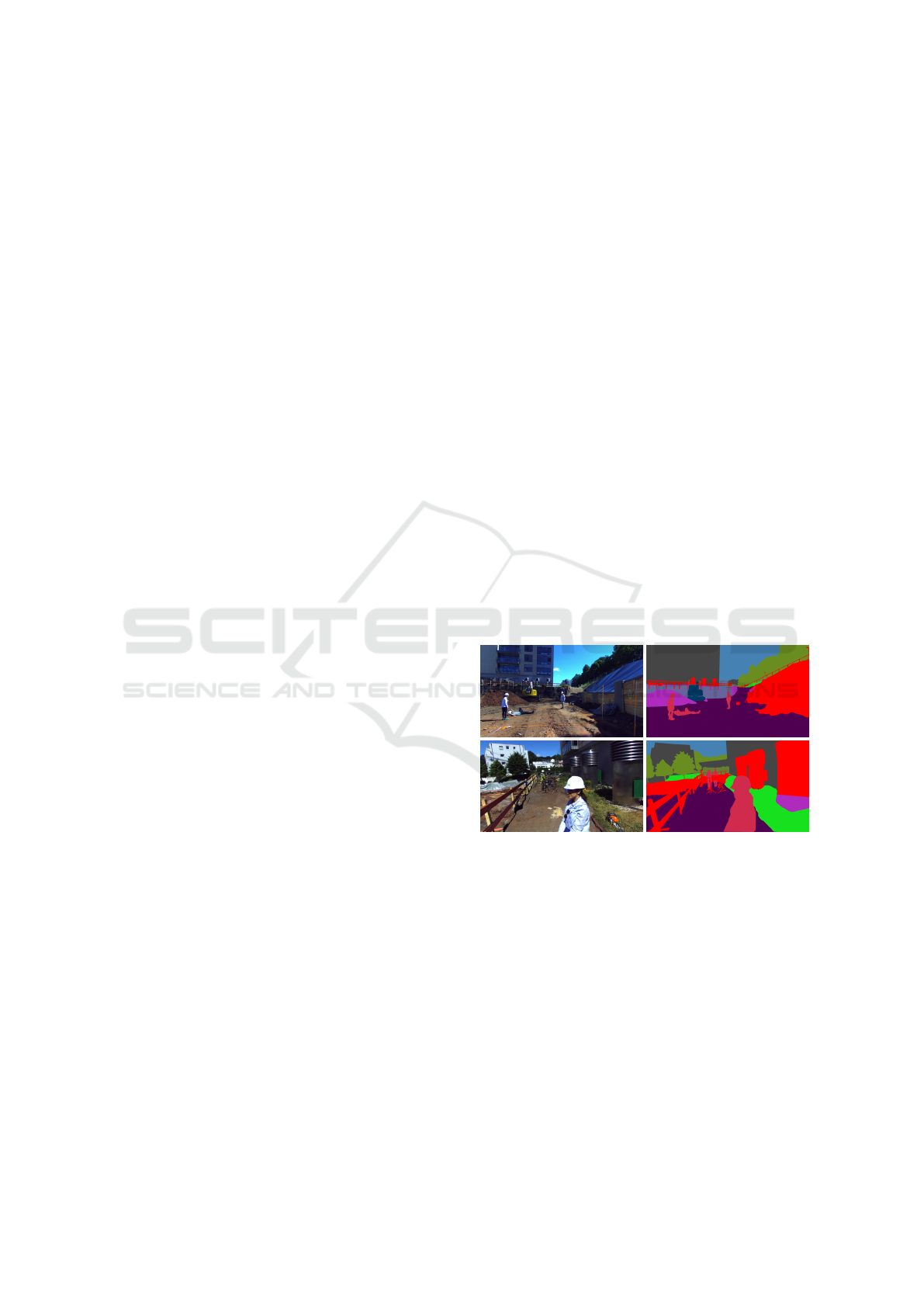
Figure 1: Full image segmentation masks (right) and their
corresponding images (left). Construction sites are common
environments for mobile working machines, but are under-
represented in most deep learning datasets.
These environments are not suitable as training im-
ages for the assistance systems deployed on industrial
vehicles and working machines, since they often op-
erate in semantically and visually distinct surround-
ings, i.e. the passable ground for a passenger car and
an excavator differ greatly and excavators encounter
different objects than cars in a city. Since Tabor et
al. (Tabor et al., 2015) have demonstrated that vi-
sual gradient orientation alignment is distinctly spe-
cific to the environment, it is unclear whether neural
networks are able to generalize from one surround-
552
Neigel, P., Rambach, J. and Stricker, D.
OFFSED: Off-Road Semantic Segmentation Dataset.
DOI: 10.5220/0010349805520557
In Proceedings of the 16th International Joint Conference on Computer Vision, Imaging and Computer Graphics Theory and Applications (VISIGRAPP 2021) - Volume 4: VISAPP, pages
552-557
ISBN: 978-989-758-488-6
Copyright
c
2021 by SCITEPRESS – Science and Technology Publications, Lda. All rights reserved
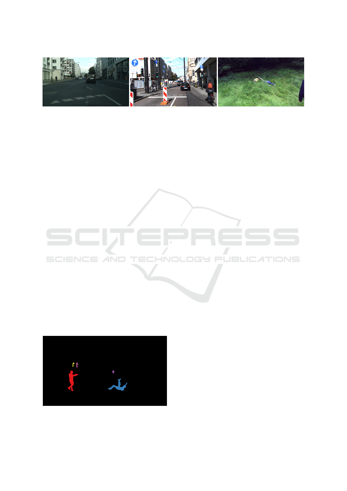
Figure 2: Exemplary frames taken from different datasets. Left: Cityscapes dataset (Cordts et al., 2016). Center: KITTI
Stereo 2015 Dataset (Geiger et al., 2012). Right: OPEDD. Urban scenes differ substantially from off-road environments in
how they are made up visually, including colour spectrum, gradient orientations and human poses.
ing to the other. Additionally, even classes found
in both environments can differ between them: Per-
sons in urban settings often display more constrained
poses (upright standing/walking) than in working en-
vironments (often crouching, lying on the floor). Al-
though these industrial vehicles are used in dozens
of industries, from coarse earthwork to constructions
and from plowers to harvesters, they are neglected by
the currently available datasets.
Previous works (Halevy et al., 2009; Zhu et al.,
2015) hint to the fact that data may be more impor-
tant to neural network detection performance than al-
gorithms or architecture. While our previous work,
OPEDD (Neigel et al., 2020), tried to address the
problem of person detection, this new paper intends to
fill the gap and add an off-road variant to the collec-
tion of semantic segmentation datasets. Our dataset
is a subset of 203 images from OPPED and there-
fore depicts the same off-road environments including
Meadows, Woods, Construction Sites, Farmland and
Paddocks. The pedestrians are portrayed in varying
poses, of which many are highly unusual in the ADAS
context, including crouching, lying down or hand-
stands to offer some extremes. To our knowledge,
there is no other dataset besides ours including real
construction sites complete with semantic segmenta-
tion. Our work comes with stereo-images, where the
left images come with manually created ground truth
segmentation masks for the full image. In addition to
per-pixel semantic labels, our work offers instance la-
Figure 3: Countable classes like persons can be separated
by instance IDs.
bels for objects where instances can be defined (thing
classes) and depth from stereo. These ground truth la-
bels allow for the tasks of semantic segmentation, ob-
ject and instance detection with bounding boxes and
object masks, as well as panoptic segmentation.
2 RELATED WORK
For the last decade, Neural-network-based ap-
proaches have been dominating many computer vi-
sion tasks in terms of segmentation quality. This fact
coupled with the need of those networks for data has
propelled the creation of many scene segmentation
datasets for ADAS. Due to the commercial nature of
said systems, most publicly available datasets show
urban surroundings or highway roads. This chapter
gives an incomplete overview of popular datasets for
different tasks and surroundings.
Cityscapes (Cordts et al., 2016) is one of the most
used image datasets for dense urban environments.
The images were obtained with the help of a stereo-
camera mounted onto a car which was driven through
50 German cities. The annotations include pixel-level
semantic labels for 30 classes including persons, cars,
roads, buildings, traffic lights, of which 17 classes are
used for evanulation in their benchmark. Out of a total
of 25,000 images, 5,000 come with finely annotated
pixel masks and the remaining 20,000 are coarsely
annotated, meaning that the pixel masks often don’t
coincide with the true object borders. In addition
to semantic labels, Cityscapes also includes instance
IDs allowing for the differentiation of countable ob-
jects. All annotations in total allow for the use of the
dataset in object-detection, semantic-, instance- and
panoptic-segmentation procedures.
Kitti (Geiger et al., 2012) is another widely used
dataset for driving scenes. It displays mostly ur-
ban environments with class definitions similar to the
Cityscapes dataset. In addition to two stereo-camera
pairs - one grayscale, one color - the capturing rig in-
cludes an inertial/GPS system as well as a 3D laser
scanner. This allows, in addition to per-pixel semantic
OFFSED: Off-Road Semantic Segmentation Dataset
553
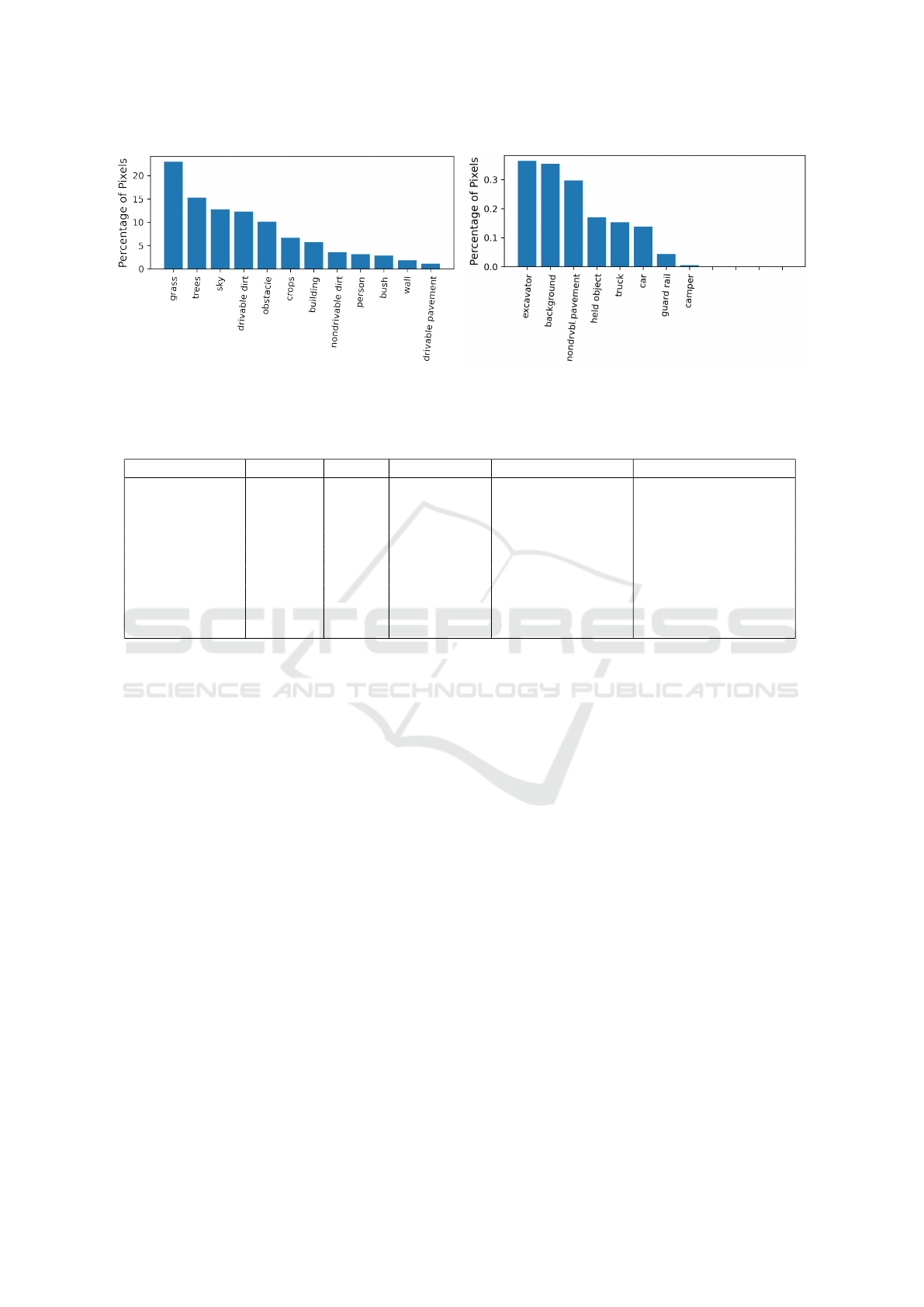
Figure 4: Percentage of pixels belonging to each class over the whole dataset. Left and right plots have different y-axis scales
for better visibility.
Table 1: Comparison of contents of datasets for semantic segmentation. N Images indicates how many images come with
ground truth annotations.
Dataset N Images Depth Segm. Masks Environment Human Poses
KITTI 2015 200 LIDAR X Urban/Street Std. Urban
Cityscapes 25,000 Stereo X Urban/Street Std. Urban
A2D2 41,277 LIDAR X Urban/Street Std. Urban
Mapillary Vistas 25,000 - X Urban/Street Mostly Std. Urban
ApolloScape 140,000 LIDAR X Urban/Street Std. Urban
BDD100K 10,000 - (X) Urban/Street Std. Urban
NREC 76,662 Stereo - Agricultural Std. Agricultural
KIT MOMA 5663 - - Multiple Off-Road Contruction
OFFSED 203 Stereo X Multiple Off-Road Wide Range, Unusual
labels, also the addition of ground truth data for depth,
3D bounding boxes and camera trajectory. For this
reason the KITTI dataset offers a large array of bench-
marks, from object detection and semantic segmen-
tation over depth estimation up to odometry, track-
ing and scene flow. For semantic segmentation, only
the subset KITTI 2015 offers according segmentation
masks.
The Audi Autonomous Driving Dataset (A2D2)
(Geyer et al., 2020) makes use of six cameras and
five LIDARs. It includes 41,277 frames that come
with ground truth annotations for semantic segmenta-
tion. Since the environments depicted are highways,
country roads and cities in southern Germany, it de-
fines 38 different classes, of which many are similar
to KITTI and Cityscapes.. Other provided annotations
include 3D point clouds, 3D bounding boxes and in-
stance segmentation in addition to data like steering
wheel angle, throttle, and braking.
Mapillary Vistas (Neuhold et al., 2017) is a dataset
containing 25,000 images from locations around the
world including parts of Europe, North and South
America, Asia, Africa and Oceania, therefore cover-
ing large diversity and geographic extent. The frames
are taken from a wide range of capture devices includ-
ing mobile phones, tablets, action cameras and pro-
fessional capturing rigs. While the environments en-
compass urban, countryside and off-road scenes, most
images are still taken from the street or dirt tracks.
The ground truth annotations provide pixel-level se-
mantic labels for 66 classes and instance labels for a
subset of 37 classes.
One of the largest datasets with a focus on ADAS
is ApolloScape (Huang et al., 2020). Captured with
a rig including a stereo camera, two 360
◦
laser scan-
ners and an IMU/GNSS system, it consists of 140,000
video frames taken on urban locations in China. It
supplies ground truth per-pixel semantic labels as
well as 3D point clouds, of which some points are
also semantically labelled, for 28 classes. Addition-
ally, instance ID’s, 3D car instances, lane markings
and camera locations are provided.
The Berkeley Deep Drive Dataset (BDD100K)
(Yu et al., 2020) focuses on object detection, sup-
plying 100,000 videos of street and traffic scenes in
the USA with ground truth bounding boxes for 10
classes. Semantic segmentation masks are provided
for 10,000 videos and 40 classes, of which a small
subset comes with instance IDs. Additional data pro-
vided includes car trajectories from IMU/GPS and
lane markings. In contrast to the previous works, the
National Robotics Engineering Center Agricultural
VISAPP 2021 - 16th International Conference on Computer Vision Theory and Applications
554
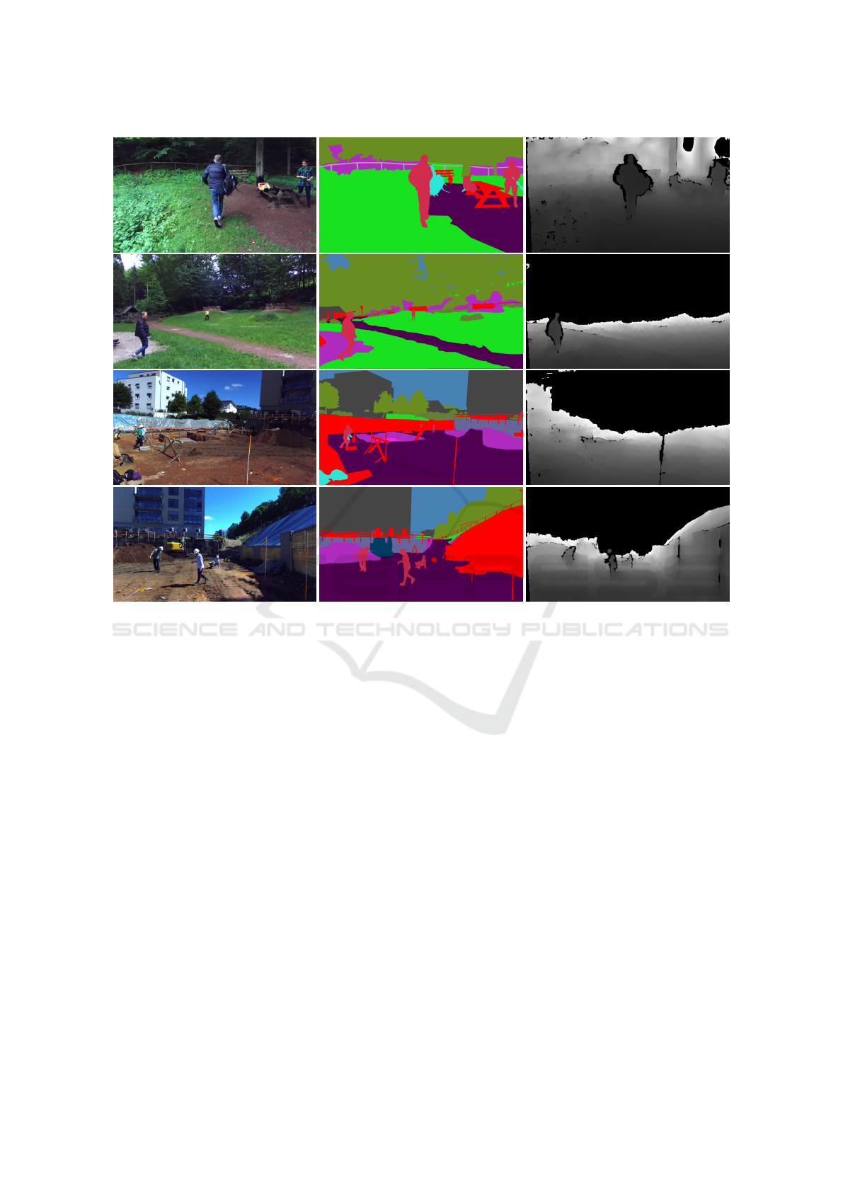
Figure 5: Selection of images from the presented dataset. Left column: Left frame of stereo image. Center column: Corre-
sponding segmentation masks. Right column: Corresponding depth maps. The dataset shows a wide range in environments
and unusual human poses.
Person-Detection dataset (Pezzementi et al., 2018) fo-
cuses on off-road environments instead of urban traf-
fic scenes. Consisting of 95,000 images taken in ap-
ple and orange orchards of which 76,662 have an-
notations, it provides only bounding boxes for per-
sons, making it unsuitable for complete scene seman-
tic segmentation or instance segmentation. A fur-
ther distinctive feature of this dataset is the variety of
poses that persons are depicted in: Compared to city
scenes, workers in the orchards are found in crouch-
ing, stretching and otherwise unusual poses more of-
ten.
The Karlsruhe Mobile Machines dataset (KIT
MOMA) (Xiang et al., 2020) sets a focus on envi-
ronments where industrial vehicles and mobile ma-
chines like excavators, wheel loaders, bulldozers and
dumpers operate. The collection includes 5,663 im-
ages taken from outside of the vehicles. Eight dif-
ferent vehicle classes are defined and annotated man-
ually with ground truth bounding boxes, resulting in
19,997 object instances.
3 DATA CAPTURING
The images in this dataset are a subset of the data from
our previous work, OPEDD (Neigel et al., 2020).
OPEDD consists of 1018 stereo images that were cap-
tured in five different environments, meadows, woods,
construction sites, farm-land and paddocks. The
images were extracted from stereo video sequences
recorded with a ZED camera (“ZED”, 2020) loss-
less compression. The images are rectified and depth
from stereo is provided. The full technical details of
the data capturing process can be taken from (Neigel
et al., 2020).
4 ANNOTATIONS
Manually annotating images for semantic segmenta-
tion is a labour intensive and costly task. The ground
truth semantic segmentation annotations were created
OFFSED: Off-Road Semantic Segmentation Dataset
555
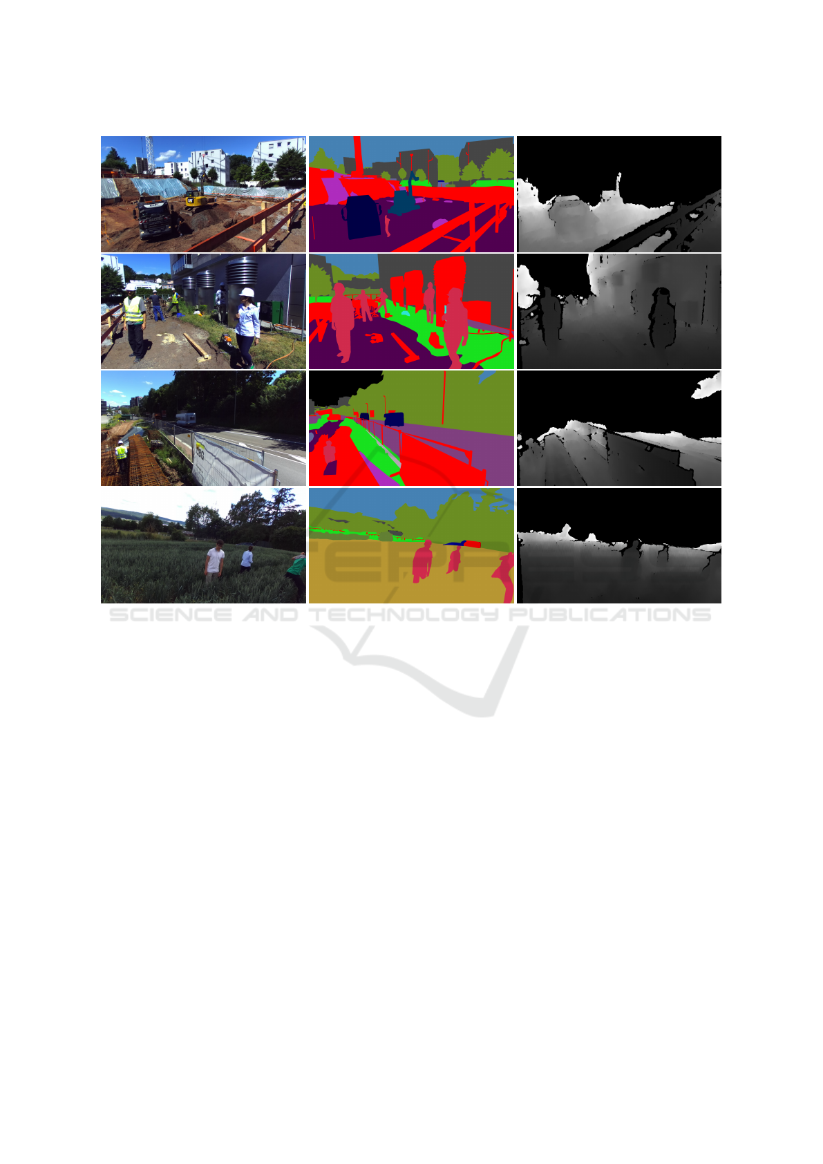
Figure 6: Further selection of environments contained in the presented dataset. Left column: Left frame of stereo image.
Center column: Corresponding segmentation masks. Right column: Corresponding depth maps. Among other environments,
our dataset delivers segmentation masks for real construction sites.
manually with the help of the annotation tool CVAT
(“Computer Vision Annotation Tool”, 2020). In this
tool annotators draw polygons for every object and
label them according to predefined classes. Addi-
tionally, the polygons are assigned a z-layer level and
thereby a depth ordering. This allows for borders be-
tween polygons to be drawn only once, saving time
in the annotation process. The 19 classes we defined
are grass, trees, sky, drivable and non-drivable dirt,
obstacles, crops, building, person, bush, wall, driv-
able and non-drivable pavement, held/carried object,
truck, car, excavator, guard rail and camper. The full
image pixel masks are then created from the polygons
with the consideration of the polygon depth.
Each polygon can be supplied with additional ar-
bitrary attributes. For a subset of countable thing-
classes we assign instance identifiers to each object-
polygon. Since most classes (e.g. grass, sky, dirt) are
not suitable for division into instances, this is done for
only a small subset of classes: person, car, excavator,
truck and camper. In some instances single objects
are comprised of several polygons. This is necessary
when an an object is visually cut in two or more parts
by an occluding object.
Because the segmentation masks are created from
polygons, the masks can be extended to include more
classes easily. This can be desirable if classes should
be divided into more fine-grained sub-classes. The
classes were chosen in a way that reflects possible en-
vironments for mobile working machines. Special in-
terest should be paid to classes like drivable and non-
drivable dirt or pavement/concrete since these classes
are dependent on the ego-vehicle and are therefore
prone to semantic as well as visual ambiguity. A dirt
heap that can be driven over by a larger machine may
pose an obstacle for a smaller one for example. Dur-
ing the annotation process, we labelled classes with
the background of ADAS for mobile working ma-
chines in mind and used that fact to guide decisions
e.g. between drivable and non-drivable dirt.
VISAPP 2021 - 16th International Conference on Computer Vision Theory and Applications
556

5 CONCLUSIONS AND FUTURE
WORK
In this paper we presented an extension to our pre-
vious off-road pedestrian detection dataset OPEDD,
which adds full image semantic segmentation an-
notations to 203 images. To this end we defined
19 semantic classes: grass, trees, sky, drivable and
non-drivable dirt, obstacles, crops, building, per-
son, bush, wall, drivable and non-drivable pavement,
held/carried object, truck, car, excavator, guard rail
and camper. The chosen images were selected in a
way that retains the wide range of outdoor environ-
ments and special human poses that were depicted in
OPEDD. For future work, we intend to completely se-
mantically annotate some of the video sequences the
images were taken from, to allow for the use of the
dataset in semantic SLAM and tracking tasks.
ACKNOWLEDGEMENTS
We would like to thank Ahmed Elsherif and Mitesh
Mittal for their help in annotating and reviewing the
quality of the annotations.
REFERENCES
Computer Vision Annotation Tool (2020). URL: https://
software.intel.com/content/www/us/ens/develop/
articles/computer-vision-annotation-tool-a-universal-
approach-to-data-annotation. html (visited on
12/18/2020).
Cordts, M., Omran, M., Ramos, S., Rehfeld, T., Enzweiler,
M., Benenson, R., Franke, U., Roth, S., and Schiele,
B. (2016). The Cityscapes Dataset for Semantic Urban
Scene Understanding. Proceedings of the IEEE Com-
puter Society Conference on Computer Vision and
Pattern Recognition, pages 3213–3223.
Geiger, A., Lenz, P., and Urtasun, R. (2012). Are we
ready for Autonomous Driving? The KITTI Vision
Benchmark Suite. Proceedings of the IEEE Computer
Society Conference on Computer Vision and Pattern
Recognition, pages 3354–3361.
Geyer, J., Kassahun, Y., Mahmudi, M., Ricou, X., Durgesh,
R., Chung, A. S., Hauswald, L., Pham, V. H.,
M
¨
uhlegg, M., Dorn, S., Fernandez, T., J
¨
anicke, M.,
Mirashi, S., Savani, C., Sturm, M., Vorobiov, O.,
Oelker, M., Garreis, S., and Schuberth, P. (2020).
A2D2: Audi Autonomous Driving Dataset.
Halevy, A., Norvig, P., and Pereira, F. (2009). The un-
reasonable effectiveness of data. Intelligent Systems.
IEEE.
Huang, X., Wang, P., Cheng, X., Zhou, D., Geng, Q., and
Yang, R. (2020). The ApolloScape Open Dataset
for Autonomous Driving and Its Application. IEEE
Transactions on Pattern Analysis and Machine Intel-
ligence, 42(10):2702–2719.
Neigel, P., Ameli, M., Katrolia, J., Feld, H., Wasenm
¨
uller,
O., and Stricker, D. (2020). OPEDD: Off-road pedes-
trian detection dataset. Journal of WSCG, 28(1-
2):207–212.
Neuhold, G., Ollmann, T., Bulo, S. R., and Kontschieder,
P. (2017). The Mapillary Vistas Dataset for Semantic
Understanding of Street Scenes. Proceedings of the
IEEE International Conference on Computer Vision,
2017-October:5000–5009.
Pezzementi, Z., Tabor, T., Hu, P., Chang, J. K., Ramanan,
D., Wellington, C., Wisely Babu, B. P., and Herman,
H. (2018). Comparing apples and oranges: Off-road
pedestrian detection on the National Robotics Engi-
neering Center agricultural person-detection dataset.
Journal of Field Robotics, 35(4):545–563.
Tabor, T., Pezzementi, Z., Vallespi, C., and Wellington, C.
(2015). People in the weeds: Pedestrian detection
goes off-road. In 2015 IEEE International Sympo-
sium on Safety, Security, and Rescue Robotics (SSRR),
pages 1–7.
Xiang, Y., Wang, H., Su, T., Li, R., and Geimer, M. (2020).
KIT MOMA: A Mobile Machines Dataset. ArXiv
Preprint.
Yu, F., Chen, H., Wang, X., Xian, W., Chen, Y., Liu, F.,
Madhavan, V., and Darrell, T. (2020). BDD100K: A
Diverse Driving Dataset for Heterogeneous Multitask
Learning.
ZED (2020). URL: https://www.stereolabs.com/zed/ (vis-
ited on 12/18/2020).
Zhu, X., Vondrick, C., Fowlkes, C. C., and Ramanan, D.
(2015). Do We Need More Training Data? Interna-
tional Journal of Computer Vision (IJCV), pages 1–
17.
OFFSED: Off-Road Semantic Segmentation Dataset
557
