
Asset Detection in Railroad Environments using Deep Learning-based
Scanline Analysis
Johannes Wolf, Rico Richter and J
¨
urgen D
¨
ollner
Hasso Plattner Institute, Faculty of Digital Engineering, University of Potsdam, Germany
Keywords:
LiDAR, 3D Point Clouds, Digital Image Analysis, Semantic Classification.
Abstract:
This work presents an approach for the automated detection of railroad assets in 3D point clouds from mobile
mapping LiDAR scans using established convolutional neural networks for image analysis. It describes how
images of individual scan lines can be generated from 3D point clouds. In these scan lines, objects such as
tracks, signal posts, and axle counters can be detected using artificial neural networks for image analysis, pre-
viously trained on ground-truth data. The recognition results can then be transferred back to the 3D point cloud
as a semantic classification result, or they are used to generate geometry or map data for further processing in
GIS applications. Using this approach, trained objects can be found with high automation. Challenges such as
varying point density, different data characteristics of scanning devices, and the massive amount of data can
be overcome with this approach.
1 INTRODUCTION
Railway infrastructure is an essential backbone of to-
day’s transportation sector. Whether people or goods
are being transported, trains serve as vehicles with ex-
ceptionally high transport capacity. To ensure safe op-
eration, the infrastructure must be continuously mon-
itored. Maintenance and repairs are time-consuming
and costly, and breakdowns should be prevented as
far as possible. For this purpose, it is advantageous to
have up-to-date information on the railroad bed con-
dition at all times (Chia et al., 2019).
While people often still have to walk along the
tracks to check them for problems (Sanne, 2008),
trains can be equipped with suitable hardware to col-
lect digital information about the condition and up-
date it continuously. For example, the tracks and ties’
condition can be checked, and it can be determined
whether the track or ballast is sagging at any point and
whether the clearance area is being violated by grow-
ing vegetation. If this data is collected permanently,
changes can be registered quickly, and the responsi-
ble authorities can react directly and take measures
before a failure occurs (Ciocoiu et al., 2017).
Many national railroad companies, such as
Deutsche Bahn in Germany and SBB in Switzerland,
operate measuring trains that examine the tracks and
their surroundings in detail during the journey (Wirth,
2008). Besides photo data, LiDAR scans are used for
precise measurements, resulting in 3D point clouds.
3D point cloud analysis is done in different ways
depending on multiple factors. Data can be acquired
either with airborne systems or with mobile mapping
vehicles at ground level. Furthermore, the data can be
acquired either by LiDAR scans or via photogramme-
try. This work focuses on processing LiDAR scans
from mobile mapping scans in railroad environments.
Capturing with LiDAR is particularly suitable in
the railroad environment because LiDAR is less de-
pendent on environmental variables such as changing
lighting in tunnels. On the other hand, photogramme-
try is less suitable because, in many situations, it is
not possible to generate a sufficient number of differ-
ent perspectives on an object.
Figure 1 shows a train with LiDAR scanners
mounted in front of the train. These scanners typi-
cally generate 3D point clouds with a scan line dis-
tance of 5 to 15 cm. The rotation of the laser beam
during the measurement and simultaneous movement
of the train result in a series of measurements in the
form of a helix, in which each measuring point can be
located by its distance from the scanner and the cur-
rent angle of the laser. The points of one rotation of
the laser are called a scan line. The resulting points
can be visualized as a 3D point cloud of the entire
track environment. Figure 2 shows a section of such
a 3D point cloud. The individual scan lines, each of
which are here 8 cm apart, are clearly visible.
Wolf, J., Richter, R. and Döllner, J.
Asset Detection in Railroad Environments using Deep Learning-based Scanline Analysis.
DOI: 10.5220/0010314704650470
In Proceedings of the 16th International Joint Conference on Computer Vision, Imaging and Computer Graphics Theory and Applications (VISIGRAPP 2021) - Volume 4: VISAPP, pages
465-470
ISBN: 978-989-758-488-6
Copyright
c
2021 by SCITEPRESS – Science and Technology Publications, Lda. All r ights reserved
465
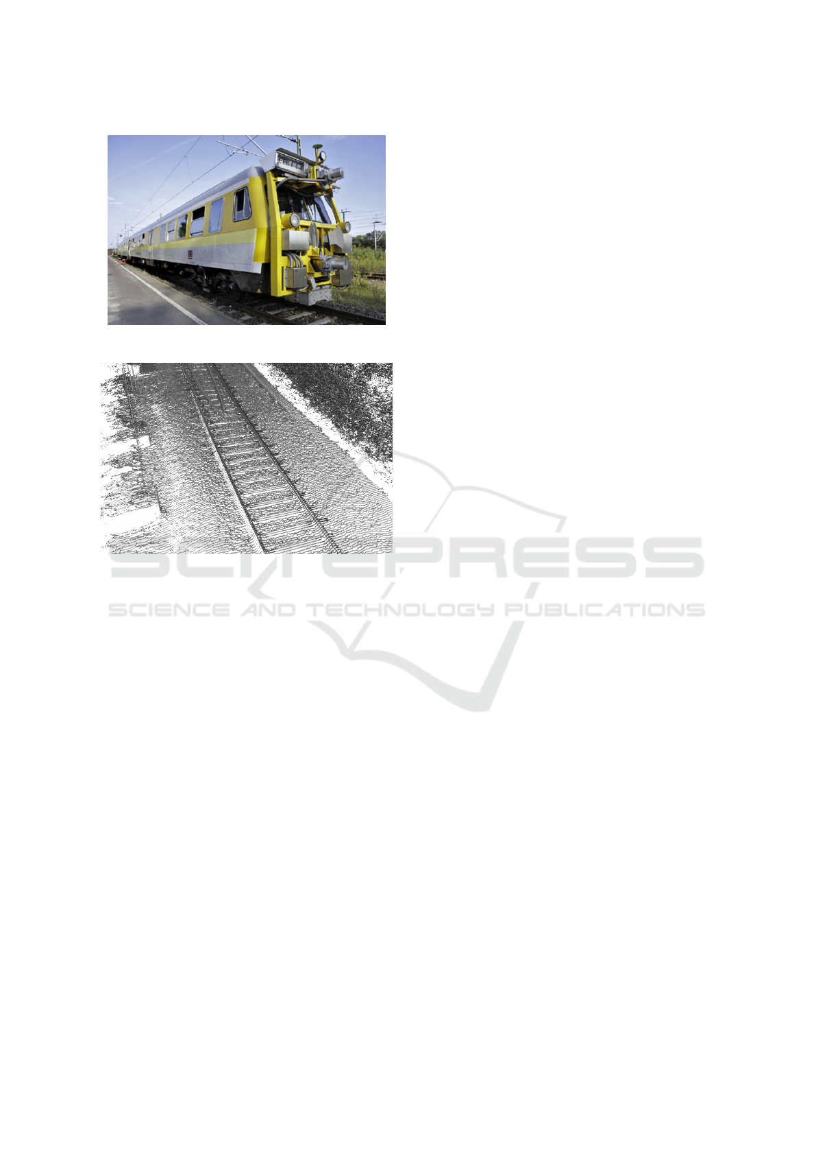
Figure 1: Measurement train “Limez III” (Wirth, 2008).
Figure 2: 3D point cloud from a railroad mobile mapping
LiDAR scan, colored based on intensity values.
Automatic analysis of the data for early problem
detection depends on the semantic classification of the
information. Thus, points captured in the 3D point
cloud must be grouped and identified in order to be
able to derive statements about the nature of and dis-
tances between objects.
For this purpose, geometric analyses are often
used, which analyze the properties of points and point
groups to derive the most probable semantic class
(Wolf et al., 2019b). In recent work, artificial neu-
ral networks such as PointNet++, which have learned
to derive semantic classes from the structure of 3D
point clouds, have also been delivering good results
(Qi et al., 2017; Wang et al., 2019; Zhang et al., 2019).
The analysis of image data with Convolutional
Neural Networks (CNNs), on the other hand, has
been in use for a considerably longer time, and many
techniques have been continuously improved over the
years. Therefore, this paper presents a concept of how
the scan line data of the LiDAR scans from railroad
environments can be converted into image data to sub-
sequently identify objects therein with established im-
age analysis methods and use this information for fur-
ther analyses.
2 RELATED WORK
Many analysis steps using 3D point clouds as input
depend on using information about surfaces in the
data since planar surfaces provide the basis for many
other recognition steps. Approaches have been devel-
oped to perform a planar segmentation (Oehler et al.,
2011). Plane recognition is even possible in sparse
data, e. g., when lidar data from the environment of a
moving car are acquired, as Wang et al. (2016) show.
Guan et al. (2016) compare how LiDAR informa-
tion is used for road information inventory in various
publications. For autonomous driving, the evaluation
of LiDAR data in road space must be very fast so that
the current environment can be evaluated immediately
without delay. The use of CNNs for this purpose was
investigated by Caltagirone et al. (2017). Specific ob-
jects in the road space, such as people, can also be
detected in the data and used for safely controlling
vehicles (Navarro-Serment et al., 2010). Many meth-
ods can also be transferred from the road to tracks.
Stein et al. (2016) investigate how tracks of light rails
can be detected automatically in LiDAR scans using
variations in the distance values.
Arastounia (2017) points out the necessity of find-
ing assets in the track environment and presents an
algorithm for detecting rail tracks and contact cables
by geometrical analysis of point positions based on
an automated seed point search. G
´
ezero and Antunes
(2019) describe an approach to evaluate LiDAR point
clouds of a rail environment using the angular infor-
mation of a vertically mounted scanner at the front
of the train. Along an imaginary line lying under
the scanner, they determine the rails on either side of
it and the ballast’s dimensions. In his doctoral the-
sis, Taheriandani (2016) describes approaches for de-
tailed track analysis with LiDAR scanners that are di-
rectly aimed at the rails under the train to detect the
smallest deviations. Shang et al. (2018) present an
approach for finding rail defects by using CNNs on
railway image data.
Detecting structures and objects in images is a rel-
evant research field for many applications, such as
face recognition, license plate identification, or med-
ical imagery analysis. U-Net, initially developed for
the medical sector, is now widely used in image seg-
mentation (Ronneberger et al., 2015). With this net-
work’s help, specific areas in images can be recog-
nized with pixel accuracy, such as cancer cells and
streets in aerial images (Zhang et al., 2018). Another
promising implementation is YOLO (You only look
once), which only returns labeled bounding boxes, but
can process the provided images very fast (Redmon
and Farhadi, 2018). In a railway context, Yanan et al.
VISAPP 2021 - 16th International Conference on Computer Vision Theory and Applications
466
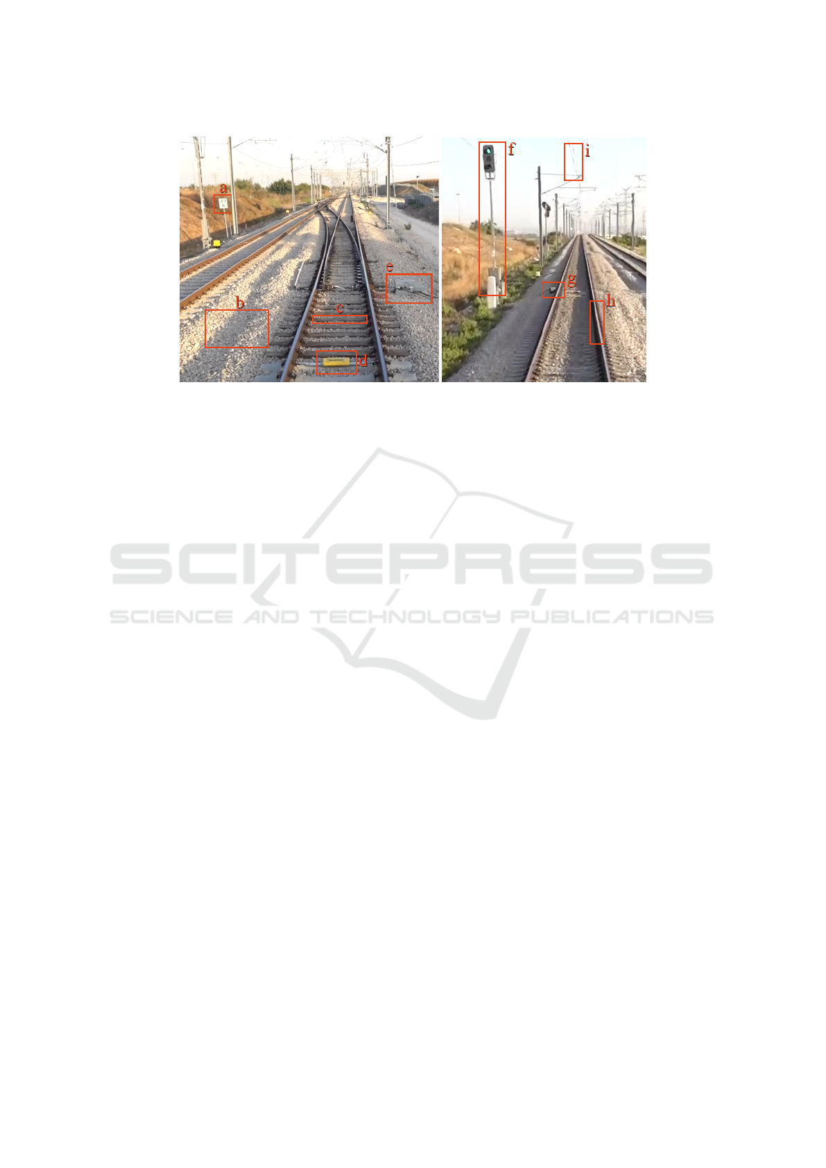
Figure 3: Typical objects found in railroad environments: Sign (a), ballast (b), tie (c), balise (d), switch motor (e), signal
pole (f), axle counter (g), rail (h), catenary (i).
(2018) use YOLO to detect problems on the surface
of rails, Yang et al. (2020) use it to recognize pole
numbers in images.
Hu and Ye (2013) use scan lines in aerial data to
detect buildings while Yan et al. (2016) present an ap-
proach using them to recognize road markings in mo-
bile mapping data.
3 CONCEPT
The idea of the approach presented in this paper is
based on the assumption that the performance of 2D
image recognition can be utilized due to the nature
of the data when individual scan lines are available.
Thus, even three-dimensional objects can be precisely
and efficiently identified and semantically classified
via this approach. Typical objects that should be clas-
sified in railroad data are shown in Figure 3.
When rendering images from 3D point cloud data
for object classification, positioning the virtual cam-
era is of utmost importance. As described in previous
work (Wolf et al., 2019a), top-down views are suitable
for detecting objects such as road markings and utility
hole covers in mobile mapping data. However, having
catenaries and signal bridges above railroad tracks,
these are occluding essential parts of the track in a
top-down view and are therefore hindering compre-
hensive classification. Furthermore, in tunnels, cate-
naries and signals are often mounted to the ceiling,
making it very difficult to do a top-down view analy-
sis. Using the scan lines is an obvious choice because
all objects are captured from the train’s perspective,
and therefore everything necessary is visible in the
data.
First, individual scan lines are identified: At best,
the measurement data already contain information
about the point’s position within the individual scan
lines by their sequence or timestamp. In this case, all
points can be combined within a run of possible scan
angles from 0 to 360 degrees, with 0 degrees being
straight above the train, and as soon as the angle of
the following point jumps back, a new scan line be-
gins. In a prototypic implementation, about 21 mil-
lion points per second were segmented this way into
individual scan lines from an ordered 3D point cloud.
If this information is not available in the current
data set, the scan lines can also be derived in an
additional preparatory step: Along the measurement
data’s trajectory, scan lines are generated perpendic-
ular to it by grouping adjacent points into scan lines.
Here, approximate solutions are sufficient because the
affiliation to a particular scan line is not decisive for
the later analysis.
Now all scan lines can be rendered individually
as 2D images. A particular color (e. g., white (255))
is used as masking for the areas not containing data,
and all other pixels can be colored with gray levels ac-
cording to the intensity of the measuring points at the
respective position, mapping the lowest intensity to
black (0), the highest to almost white (254). An addi-
tional image channel containing the rendered points’
IDs will also be included so that the result can be
mapped back into the point cloud after the image clas-
sification. If several points are rendered in the same
pixel, the last rendered point’s ID is stored.
Figure 4 shows the difference of the surface’s
smoothness between two rails depending on whether
a tie is placed at this position or the ballast is exposed.
Thus, ties can be identified if the scan lines are placed
at suitable distances from each other.
Asset Detection in Railroad Environments using Deep Learning-based Scanline Analysis
467
(a) Two rails with a tie in between.
(b) Two rails with ballast in between.
Figure 4: Two scan lines of a railroad track on a ballast hill.
Grayscale represents the intensity values of the points.
Figure 5: Scan lines of two rails (R), a switch tongue (S)
and a box containing the motor (M) next to the rails.
A large variety of objects can be found in the im-
mediate neighborhood of the rails. Figure 5 shows a
scan line at the beginning of a track switch, where the
switch tongue is placed close to one of the rails and
a box with the switch motor on the other side of the
rail. The box shadows the area on the right side, so
this part of the ballast hill is missing.
Figure 6 shows two scan lines of a signal post next
to the rails. Due to its shape, the front of the actual
signal can be seen in multiple scan lines before the
signal post. In total, the structure has a length of ap-
proximately 1.5 meters.
Possible semantic classes analyzed with this tech-
nique are rails (running rails, guard rails, switch
tongues), ties, ballast, catenary posts, signals, signal
posts, and signal gantries.
A large number of rendered images will be needed
for training purposes. This data could be generated
manually by labeling individual pixels and bounding
boxes within the scan line images. A faster approach
would be using pre-classified 3D point clouds (which
have been created either manually or by a different
automated approach) so that the semantic informa-
tion can already be included when rendering the 2D
images.
Suitable networks for the analysis of the rendered
images are, for example, U-Net and YOLO. Both
follow a different approach but could provide sim-
ilarly relevant results for the application described
here. While U-Net classifies individual pixels, YOLO
only determines bounding boxes for recognized ob-
jects. However, since there are hardly any overlaps of
(a) Front part of the signal.
(b) Signal post, six scan lines behind the one
above.
Figure 6: Scan lines of a signal post next to two rails. An
axle counter is attached to the outside of the left rail.
objects in individual scan lines and the objects to be
found, such as rails, ties, and signals, can be covered
relatively well by rectangles, this result should also
be sufficient. When using YOLO, all non-background
pixels within the bounding box of a recognized object
could get assigned the corresponding semantic class,
and then they would be treated similarly to the images
classified pixel by pixel with U-Net.
Figures 7 and 8 show exemplary results of the se-
mantic classification with YOLO and U-Net on a scan
line.
Once the semantic class for each pixel is deter-
mined, the information can be mapped back into the
3D point cloud by using the ID channel. In case the
point density is higher than the resolution of the ren-
dered images, several points have been covered by the
same pixel. In this case, all points in the immediate
neighborhood of the point just classified can also re-
ceive the respective semantic class so that all points
will receive semantic information.
VISAPP 2021 - 16th International Conference on Computer Vision Theory and Applications
468
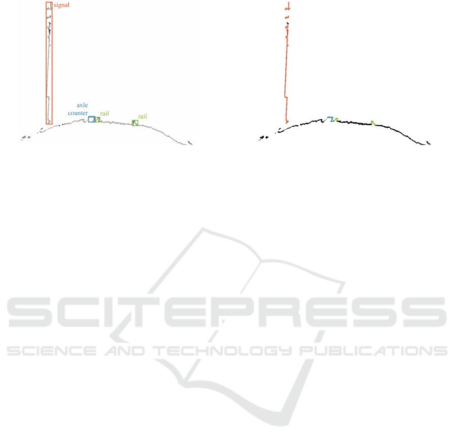
Figure 7: Exemplary semantic classification results of the
scan line shown in Figure 6b using YOLO. Bounding boxes
are placed around identified objects.
Processing the data results in a 3D point cloud
with semantic information attached to each point.
This data can then be used for the previously de-
scribed use cases.
Simple post-processing steps and plausibility
checks can further improve the results of the classi-
fication. For example, axle counters must lie close to
the track, and rails of a track always run parallel with a
fixed, previously known distance between them. Such
conditions can be checked for after the classification.
For example, objects identified as axle counters but
not located right next to a track could then be dis-
carded and, e. g., classified as “other”.
4 CONCLUSION AND FUTURE
WORK
First prototypical tests show that the described ap-
proach is suitable for the semantic classification of
3D point clouds of railroad environments. Individ-
ual scan lines can be analyzed by rendering images
and using established image analysis for the classifi-
cation. However, the performance is still to be deter-
mined in more extensive tests. It should also be eval-
uated whether using one-dimensional CNNs as they
are used, e. g., for sound classification or movement
recognition (Cho and Yoon, 2018; Abdoli et al., 2019)
can perform more efficient on the given task.
The 3D point clouds classified by this approach
can then be used for various tasks in track mainte-
nance. For example, location maps could be gener-
ated for the detected objects in the track area, or ex-
isting data could be compared with the information
obtained here and adjusted if needed.
The approach can be extended in several ways to
presumably further improve the results. The gener-
Figure 8: Exemplary semantic classification results of the
scan line shown in Figure 6b using U-Net. Points are col-
ored based on semantic class: Signal (red), rail (green), axle
counter (blue), other (black).
ated images could be centered along the train’s trajec-
tory, so the position within the images provides infor-
mation about the objects displayed. For example, the
rails would then always be found in a similar position.
Furthermore, several scan lines could be viewed si-
multaneously to enrich the images with context infor-
mation. For this purpose, the images could be given
additional layers so that, for example, three or five
scan lines are contained in one image, and the preced-
ing and following scan lines have additional influence
on the scan line to be analyzed.
REFERENCES
Abdoli, S., Cardinal, P., and Koerich, A. L. (2019). End-
to-end environmental sound classification using a 1d
convolutional neural network. Expert Systems with
Applications, 136:252–263.
Arastounia, M. (2017). An enhanced algorithm for concur-
rent recognition of rail tracks and power cables from
terrestrial and airborne lidar point clouds. Infrastruc-
tures, 2(2):8.
Caltagirone, L., Scheidegger, S., Svensson, L., and Wahde,
M. (2017). Fast lidar-based road detection using fully
convolutional neural networks. In 2017 IEEE In-
telligent Vehicles Symposium (IV), pages 1019–1024.
IEEE.
Chia, L., Bhardwaj, B., Lu, P., and Bridgelall, R. (2019).
Railroad track condition monitoring using inertial sen-
sors and digital signal processing: A review. IEEE
Sensors Journal, 19:25–33.
Cho, H. and Yoon, S. M. (2018). Divide and conquer-
based 1d cnn human activity recognition using test
data sharpening. Sensors, 18(4):1055.
Ciocoiu, L., Siemieniuch, C. E., and Hubbard, E.-M.
(2017). From preventative to predictive maintenance:
The organisational challenge. Proceedings of the In-
Asset Detection in Railroad Environments using Deep Learning-based Scanline Analysis
469

stitution of Mechanical Engineers, Part F: Journal of
Rail and Rapid Transit, 231(10):1174–1185.
G
´
ezero, L. and Antunes, C. (2019). Automated three-
dimensional linear elements extraction from mobile
lidar point clouds in railway environments. Infrastruc-
tures, 4(3):46.
Guan, H., Li, J., Cao, S., and Yu, Y. (2016). Use of mobile
lidar in road information inventory: A review. Interna-
tional Journal of Image and Data Fusion, 7(3):219–
242.
Hu, X. and Ye, L. (2013). A fast and simple method of
building detection from lidar data based on scan line
analysis. ISPRS Annals of the Photogrammetry, Re-
mote Sensing and Spatial Information Sciences, pages
7–13.
Navarro-Serment, L. E., Mertz, C., and Hebert, M.
(2010). Pedestrian detection and tracking using three-
dimensional ladar data. The International Journal of
Robotics Research, 29(12):1516–1528.
Oehler, B., Stueckler, J., Welle, J., Schulz, D., and Behnke,
S. (2011). Efficient multi-resolution plane segmenta-
tion of 3d point clouds. In International Conference
on Intelligent Robotics and Applications, pages 145–
156. Springer.
Qi, C. R., Yi, L., Su, H., and Guibas, L. J. (2017). Point-
net++: Deep hierarchical feature learning on point sets
in a metric space. In Advances in neural information
processing systems, pages 5099–5108.
Redmon, J. and Farhadi, A. (2018). Yolov3: An incremental
improvement. arXiv preprint arXiv:1804.02767.
Ronneberger, O., Fischer, P., and Brox, T. (2015). U-net:
Convolutional networks for biomedical image seg-
mentation. In International Conference on Medical
image computing and computer-assisted intervention,
pages 234–241. Springer.
Sanne, J. M. (2008). Framing risks in a safety-critical and
hazardous job: risk-taking as responsibility in railway
maintenance. Journal of Risk Research, 11:645 – 658.
Shang, L., Yang, Q., Wang, J., Li, S., and Lei, W. (2018).
Detection of rail surface defects based on cnn im-
age recognition and classification. 2018 20th Interna-
tional Conference on Advanced Communication Tech-
nology (ICACT), pages 45–51.
Stein, D., Spindler, M., Kuper, J., and Lauer, M. (2016).
Rail detection using lidar sensors. International
Journal of Sustainable Development and Planning,
11(1):65–78.
Taheriandani, M. (2016). The Application of Doppler LI-
DAR Technology for Rail Inspection and Track Geom-
etry Assessment. PhD thesis, Virginia Tech.
Wang, L., Meng, W., Xi, R., Zhang, Y., Ma, C., Lu, L., and
Zhang, X. (2019). 3d point cloud analysis and clas-
sification in large-scale scene based on deep learning.
IEEE Access, 7:55649–55658.
Wang, W., Sakurada, K., and Kawaguchi, N. (2016). In-
cremental and enhanced scanline-based segmentation
method for surface reconstruction of sparse lidar data.
Remote Sensing, 8(11):967.
Wirth, H. (2008). Der neue lichtraummesszug limez iii der
deutschen bahn ag. Zeitschrift f
¨
ur Geod
¨
asie, Geoin-
formation und Landmanagement, 133(3):180–186.
Wolf, J., Richter, R., Discher, S., and D
¨
ollner, J. (2019a).
Applicability of neural networks for image classifica-
tion on object detection in mobile mapping 3d point
clouds. International Archives of the Photogramme-
try, Remote Sensing & Spatial Information Sciences,
42(4/W15):111–115.
Wolf, J., Richter, R., and D
¨
ollner, J. (2019b). Techniques
for automated classification and segregation of mobile
mapping 3d point clouds. In Proceedings of the 14th
International Joint Conference on Computer Vision,
Imaging and Computer Graphics Theory and Appli-
cations, pages 201–208.
Yan, L., Liu, H., Tan, J., Li, Z., Xie, H., and Chen, C.
(2016). Scan line based road marking extraction from
mobile lidar point clouds. Sensors, 16(6):903.
Yanan, S., Hui, Z., Li, L., and Hang, Z. (2018). Rail surface
defect detection method based on yolov3 deep learn-
ing networks. In 2018 Chinese Automation Congress
(CAC), pages 1563–1568. IEEE.
Yang, Y., Zhang, W., He, Z., and Li, D. (2020). High-
speed rail pole number recognition through deep rep-
resentation and temporal redundancy. Neurocomput-
ing, 415:201–214.
Zhang, Z., Hua, B.-S., and Yeung, S.-K. (2019). Shellnet:
Efficient point cloud convolutional neural networks
using concentric shells statistics. 2019 IEEE/CVF In-
ternational Conference on Computer Vision (ICCV),
pages 1607–1616.
Zhang, Z., Liu, Q., and Wang, Y. (2018). Road extraction
by deep residual u-net. IEEE Geoscience and Remote
Sensing Letters, 15(5):749–753.
VISAPP 2021 - 16th International Conference on Computer Vision Theory and Applications
470
