
Improving the Road Network of Small Cities
Vadim Mavrin
1a
, Kirill Magdin
1b
, Aleksandr Barinov
2
, Aleksey Boyko
1c
and Artur Cherpakov
1d
1
Kazan Federal University, Suyumbike Avenue, 10A, Naberezhnye Chelny, Russian Federation
2
Murmansk State Technical University, str. Sportivnaya, 13, Murmansk, Russian Federation
Keywords: Transport System, Traffic Light Regulation, Intelligent Transport Systems, Simulation Modelling.
Abstract: The transport system is an important part in human activity and is an integral part of the successful functioning
of an urbanized territory. The historical relationship between the size of the city and the development of urban
transport is traced very well. With the growth of the city's population and its territory, there is an increase in
vehicles and traffic volume. The mobility of the population is increasing (the average number of transport
trips per resident per year), while the travel distance is also increasing. This requires the appropriate
development of transport, increasing traffic speed, and increasing the capacity of the road network. The article
is devoted to environmental problems of motor transport in small cities, where it is impossible to apply large
and expensive solutions. Two problematic intersections in similar cities were considered in Apatity and
Elabuga and measures for the reconstruction of these sections were proposed (applying adequate road
markings and changing traffic lights modes). Performing a computer experiment on constructed simulation
models showed that there is a significant potential for improving the parameters of traffic flow in these areas
and reducing the negative impact on the environment.
1 INTRODUCTION
The global urbanization affects all countries of the
world. The population and economy are concentrated
mainly in large cities, and the number of such cities is
constantly growing. One of the consequences of
urbanization is the high mobility of the population
and, as a consequence, high motorization. Along with
the positive effect of increasing motorization, traffic
intensity increases. There is a strong and complex
interaction between urbanization, motorization, and
air pollution. Everything is developing within the
framework of a number of urban restrictions that are
inevitable from a political and regulatory viewpoint,
where the environmental problem is becoming
increasingly important. The fact that transport and
regional planning influence each other and determine
air pollution is a reality that needs to be recognized in
order to consider development alternatives as soon as
possible (Farid, 2015). With the population growth of
a
https://orcid.org/0000-0001-6681-5489
b
https://orcid.org/0000-0001-6679-6580
c
https://orcid.org/0000-0002-5878-8342
d
https://orcid.org/0000-0002-9233-5056
the city and its territory there is an increase in the
number of vehicles and volume of traffic. This
requires appropriate development of transport and the
road network (CRN) (Makarova, 2017).
Problems of increasing the capacity of public
roads, which are the cause of non-compliance of
traffic conditions with standards, are one of the main
and urgent problems today.
The decrease in the capacity of suburban roads is
accompanied by processes of urbanization and
suburbanization-the causes of sprawl and growth of
cities with a continuous increase in the level of
motorization, the number of vehicles per thousand
inhabitants. As a result, the city's road network is far
from regulatory requirements.
One of the consequences of motorization is traffic
jams, which have a negative impact on people and the
economy, causing a decline in living standards in
urban settings, additional business costs, loss of
productivity, and so on. According to the 2011 urban
mobility Report, the annual waiting time in traffic has
634
Mavrin, V., Magdin, K., Barinov, A., Boyko, A. and Cherpakov, A.
Improving the Road Network of Small Cities.
DOI: 10.5220/0009838306340641
In Proceedings of the 6th International Conference on Vehicle Technology and Intelligent Transport Systems (VEHITS 2020), pages 634-641
ISBN: 978-989-758-419-0
Copyright
c
2020 by SCITEPRESS – Science and Technology Publications, Lda. All rights reserved

increased from 14 hours per capita to 34 hours per
capita since 1982. The annual financial cost of traffic
jams was more than $ 100 billion, almost $ 750 per
commuter train in the United States (Turcu, 2012).
Motor transport is the largest source of air pollution.
In Russia, starting from 2012, the volume of
emissions from motor vehicles continued to increase
and by 2018 increased from 12679 thousand tons to
15108 thousand tons (Ministry of Natural Resources
and Environment of the Russian Federation, 2019).
To some extent, this is due to the age of vehicles in
service, which increased from 11.5 years in 2010 to
13.4 in 2019 (Timerkhanov, 2020).
According to the world health organization, noise
is the second most important environmental problem
for human health after air quality. Noise from traffic
flows is extremely dangerous for human health, as it
is a source of constant noise in the immediate vicinity
of their places of residence (
National Institute for Public
Health and the Environment, 2014
).
All these facts have a negative impact on the
overall level of accidents, environmental safety, and
ultimately on the world economy. This article
attempts to suggest measures to reduce road tensions
in small cities.
2 PROBLEM STATUS: EXISTING
METHODS AND SOLUTIONS
2.1 Reduced Environmental Load Due
to Energy-Efficient Vehicles
Technical measures aimed at reducing emissions
from vehicles associated with the use of alternative
energy sources. One of the most promising strategies
to reduce CO2 emissions in urban territories is to
focus on the electric vehicles use (Hofer, 2018,
Gabsalikhova, 2018).
However, the power reserve of these vehicles is
not very high and the rapidly increasing battery load
can cause various reliability problems and peak
demand in electric power systems. Therefore, the
authors in the article «Probabilistic reliability
evaluation of distribution systems considering the
spatial and temporal distribution of electric vehicles»
(Anand, 2020) propose a new probabilistic approach
for assessing the impact of electric vehicles on the
reliability of power distribution systems.
The driving style control (human factor)
contributes to reducing emissions from road vehicles
(Cindie, 2012, Ho, 2015). So, in Melbourne and
Sydney, a tests series were carried out using the
MetroScan-TI integrated assessment system to study
how changes in driver behavior can affect emissions
(Stanley, 2018). In the research course (Mensing,
2014), the author found that the formation of
economic as well as environmental behavior in the
eco-driving field shows a significant reduction in
energy consumption due to the choice of a rational
speed and acceleration. Thus, training drivers to be
competent in road behavior (eco-driving) will reduce
emissions from vehicles.
2.2 Reduced Environmental Load Due
to Management Decisions
As urbanization increases, municipalities around the
world are becoming aware of the negative effects of
road transport, including traffic jams and air
pollution. As a result, tolling schemes were
introduced in several cities to prevent vehicles from
entering the inner city (Zhang, 2019). In the article
«Intelligent traffic control for autonomous vehicle
systems based on machine learning» (Lee, 2020), the
authors developed a traffic management system based
on machine learning predictions and a routing method
that dynamically determines routes with reduced
congestion rates and predicted congestion for critical
bottlenecks and used forecasts for adaptive routing
management of all vehicles to avoid congestion.
In the article «Judicious selection of available rail
steels to reduce life-cycle costs» (Bevan, 2020), the
authors study the performance of automobile
connections at intersections in the presence of
interference, when the communication system
implements the Non-orthogonal multiple access
(NOMA) scheme. This scheme allows you to achieve
a safer passage of intersections by vehicles. In New
York city, the most important feature of building a
traffic management strategy and developing its most
complex CRN is that the municipal authorities and
the Department of transportation strive to reduce the
number of personal vehicles per capita as much as
possible. This is achievable only if the residents of the
city have a well-built public transport network. Due
to the allocation of huge funds (about $ 10 billion in
2008), invested in the daily use of public transport,
the city encourages residents to abandon the use of
personal transport and switch to public transport.
In Sochi, a unique Integrated Traffic Management
Scheme was developed and implemented. This
scheme covers a wide range of tasks for improving
road safety and is aimed at obtaining a program for
the development of the city's CRN in the long term.
During the preparation and holding of the 2014 winter
Olympic Games, using transport modeling, the
Improving the Road Network of Small Cities
635

current road situation was analyzed, the main
parameters were obtained and the desired capacity
limits were calculated, which are achievable for the
city's CRN when implementing a set of interrelated
measures. Thus, New York, Sochi and London are
quite successful in solving similar problems, but
using different methods.
The article (Turcu, 2012) suggests an approach
based on the Internet-of-Things to solve some of the
problems that arise due to traffic jams. Moreover, this
approach provides tools for monitoring a set of
environmental parameters, including air quality, and
for early warning and warning when critical levels are
reached. This approach offers a solution for
increasing traffic-related pollution (which has a
negative impact on the environment and human
health), economic losses, and other problems caused
by traffic jams. The authors of the article (Mraihi,
201)) describe the study of the stability of road
transport systems in the Metropolitan areas of
Tunisia, where the density of the urban population is
high, and the negative consequences have become a
serious problem for the population. The authors
investigated the relationship between income and
several environmental and social negative effects of
road traffic in Tunisia during the period 1989-2008
using The Kuznets Environmental curve. They found
a monotonously increasing relationship between
carbon dioxide (CO
2
) and income, and a downward
L-shaped curve for nitrogen dioxide (NO
2
). The rest
of the negative externalities are characterized by a
monotonously growing ratio of energy consumption
to income and an inverted U-shape ratio for accidents,
as well as a monotonously growing ratio of income
and use of private vehicles.
The Article (Palconit, 2017) shows that public
transport contributes significantly to total CO2
emissions. The data collected indicate a 33%
difference in CO2 emissions between climbs and
declivitys, 16–27% between slopes and flat roads, and
10–20% between flat and mountainous roads. In
addition, for the lowest level of CO2 emission, the
optimum speed is from 40 to 50 km/h. The most
unfavorable operating vehicle modes are low speeds
and engine “idling”, when pollutants are emitted into
the atmosphere in quantities significantly exceeding
the emission under load conditions. Therefore, it is
necessary to avoid traffic jams in which the
movement parameters is characterized as “stop-and-
go”.
The document (Ullo, 2018) presents the project
idea to reating an innovative public transport system.
The proposed system is based on the use of small
vehicles with low emissions following flexible routes
that will be adapted in real time to meet customer
needs, taking into account traffic congestion and the
other transport services availability. To implement
this system, it is important to have information on the
vehicles positions, other public transit supply types,
traffic and environmental conditions in real time.
However, these methods are not suitable for every
city or locality, because they entail huge financial
costs, and it will be difficult for the city
administration to cover such costs, and for some cities
with a small population it is impossible at all.
Therefore, for small cities, it is necessary to look for
more budgetary ways and methods of solving the
existing environmental and transport problems.
So in the article (Sun, 2020) Langfang, a typical
medium-sized city bordering two megacities (Beijing
and Tianjin), is the target area for vehicle emissions
research. Studies have shown that from 2018 to 2025,
emissions in Langfang will increase faster than in
Beijing and Tianjin, indicating that medium-sized
cities may become a significant source of air pollution
in China. In the document (Villagra, 2020) the
authors focus on using existing infrastructure (traffic
lights) to address these negative issues, instead of
investing in expensive new ones. Appropriate
planning of traffic lights improves the flow of
vehicles, and at the same time-this improvement is
achieved without any additional costs and without
requiring the use of specialized applications by
drivers. And in the article (Kang, 2014) the authors
propose an approach to coordinating emergency
vehicle signals, which is designed to provide a "green
wave" for emergency vehicles.
2.3 Application of Modern Methods of
Intellectualization and Modeling to
Search for Effective Solutions
The study (Nourani, 2020) presents a model based on
artificial intelligence (AI). The authors first applied
the emotional artificial neural network, which was
calibrated using real data obtained in Nicosia
(Cyprus). The model can be used to provide higher
accuracy in predicting traffic noise. An analysis of the
input parameters sensitivity showed that the total
traffic volume is the most significant factor affecting
traffic noise in the study area. The authors conclude
that AI-based models have shown better capabilities
than traditional multilinear regression models and
empirical models.
In the article (Dev, 2020) modeling is used to
evaluate the effectiveness of circular logistics in
Industry 4.0 from the economics and ecology point of
view The virtual world effectiveness in the I4.0
iMLTrans 2020 - Special Session on Intelligent Mobility, Logistics and Transport
636

environment is studied using a reverse logistics
simulation model, including operations such as
inventory policies and production planning, family-
based dispatching rules of remanufacturing and
additive production. The remanufacturing model
explores the trade-off between setup delays and the
availability of green mobility.
Reducing the vehicles environmental load in
urban conditions largely depends on the rational
traffic routes choice. To assess the such solutions
effectiveness using simulation models. So, the article
authors (Pratama, 2019) performed an analysis of the
road network characteristics using the Vissim
simulation software, and they used the EnViver
software to analyze vehicles exhaust emissions.
Improving the effectiveness of traffic
management systems (TMS) remains an actual and
complex problem in view of this task importance -
control over the transport infrastructure. Review
(Djahel, 2015) is devoted to a comprehensive study
of the modern TMS development: an analysis of the
main problems and shortcomings of existing systems
and directions for increasing their effectiveness in
smart cities. The review presents various technologies
for collecting traffic data, including new technologies
that can significantly improve the data collected
accuracy. Review authors presented the routing
protocols used by Vehicular ad-hoc networks
(VANET) to distribute the collected data between
vehicles, and showed their respective advantages and
disadvantages. The authors investigate route planning
and traffic forecasting services with the main focus on
identifying the limitations of existing algorithms and
suggesting alternative directions for increasing
accuracy and efficiency, using the capabilities of an
intelligent vehicle and advanced parking systems to
achieve the desired accuracy level and traffic control.
With the intelligent transport systems
development, the need for reliable changes recording
in travel time of road network sections in real time
grows. This is necessary to improve the accuracy of
traffic parameters forecasts in real time. The study
(Du, 2012) proposes an adaptive model based on an
iterative combination of past information for the
current day with travel time information available at
specific points in time to predict the distribution of a
particular section road's travel time. To determine the
model of adaptive information integration, the
authors use the nonlinear programming formula with
an emphasis on information quality. The model
adapts good information, weighing it higher and
protecting the consequences of bad information,
reducing its weight. Numerical experiments show that
the proposed model adequately represents the
distribution of the short sections transit time in terms
of accuracy and reliability, while ensuring
compliance with the surrounding traffic flow's
conditions.
3 RESULTS AND DISCUSSION
Earlier, we already conducted similar studies using
microscopic simulation (Makarova, 2019). These
studies were carried out in medium-sized cities, where
the load at intersections is greater, especially during
peak hours, and where there are more options for
improving traffic and unloading problem sections of
roads. As a literary review in small cities showed,
environmental problems of motorization are also
relevant.
For the research, 2 cities were selected: Apatity,
which are located in the Murmansk region, and the city
of Elabuga, located in the Republic of Tatarstan. Both
cities have almost the same population (55,000 people
live in Apatity, 74,000 people in Elabuga), and they are
similar in structure and construction. Both cities have
an identical shape. The difference is the fact that
Elabuga is located on a flat terrain in the mean climatic,
Apatity near a mountain range in the northern climatic
zone.
We have identified the main problem areas in
selected cities and suggested possible ways to address
them or minimize them. To analyze the effectiveness
of the proposed activities, simulation models of
sections of the road network in the AnyLogic software
package were built. AnyLogic simulation modeling
provides a Road Traffic Library, enabling traffic flow
simulation with the power to deliver the most efficient
road traffic engineering and design. Clear
visualizations quickly aid development, with density
maps highlighting congestion, and animations
demonstrating traffic flow and bottlenecks. The
freedom to experiment, and the ability to optimize
accurate models, with traffic simulation software,
provides the best platform for success in road traffic
planning and engineering.
Having analyzed the map of traffic accidents, we
selected one of the most emergency intersections in
Elabuga - this is the intersection of st. Mir– st.
Molodezhnaya. A weighty argument in choosing the
intersection was the fact that it is located almost in the
center of the city and has dense buildings around itself
and, as a result, has a high concentration of vehicles
and pedestrians for the city, especially during rush
hours.
To analyze the condition of the road section the
field surveys had been made. The field surveys consist
Improving the Road Network of Small Cities
637
in fixing a specific conditions and indicators of traffic
actually occurring during a predetermined time period.
The field surveys are the only way to obtain reliable
information about the condition of the roads and allow
an accurate characterization of existing traffic and
pedestrian flows. Field surveys were carried out in
accordance with the interstate standard GOST 32965-
2014 (Standardinform, 2019). The following data were
collected: the number of vehicles in each direction of
movement and the percentage of possible options for
traffic from each direction, the average, maximum and
minimum speed of vehicles when crossing an
intersection, the number of pedestrians and the average
speed of the pedestrian flow, the operating time of each
section of the traffic light. The data collected
contributed to a more detailed simulation of the
problem area (Figure 1). The model is built on the basis
of a discrete-event simulation modeling using libraries
of modeling processes, flows and traffic. The block
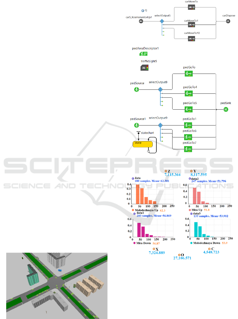
diagram of the model is shown in Figure 2.
The main problem of this intersection is the
different width of the dividing strip on st. Mir before
and after crossing with st. Molodezhnaya. It is this
factor that influenced the increased number of
accidents in this section of the road and, as a result, the
increase in pollutant emissions from vehicles.
The problem is further aggravated by the fact that
the markings are erased at the intersection, so it
becomes more difficult to notice a change in the
direction of the lane, and under unfavorable weather
conditions or limited visibility it is impossible to notice
the curvature of road.
The most obvious way to solve this problem was to
mark the intersection. The results of experiments on
simulation models without marking (Figure 3) and
with marking (Figure 4) showed that when there is
marking on the road, the number of dangerous and
conflict situations in this section of the road decreased,
the amount of harmful substances decreased by 11.8%
at the entire intersection, and decrease in average travel
time.
Figure 1: View of the simulation model of the section of the
road network of the city of Elabuga.
Figure 2: The block diagram of the model.
Figure 3: The results of the experiment on the model before
any changes (along the abscissa axis - the travel time of the
car along the site, along the ordinate axis - the number of
cars in % of the total number driving through the
intersection).
In the city of Apatity, for modeling was selected
the intersection of st. Lenin - st. Kosmonavtov
(Figure 5), since it is located, like the intersection in
Elabuga, near the center, the administration building
is also nearby, and during peak hours there is a large
concentration of vehicles.
iMLTrans 2020 - Special Session on Intelligent Mobility, Logistics and Transport
638
Figure 4: The results of the experiment on the model after
changes.
Figure 5: View of the simulation model of the road network
section of Apatity.
A feature of this intersection is the separation of
traffic and pedestrian flows. First, vehicles move
along st. Kosmonavtov, after them there is movement
along st. Lenin. In the third phase of the traffic light,
all vehicles are standing, pedestrians cross the road.
In our opinion, this is precisely the fact that
influenced the creation of traffic jams on st.
Kosmonavtov. The situation is aggravated by the fact
that the road in this direction is single-lane, and traffic
is carried out in three directions. It is impossible to
increase the number of lanes due to the lack of
sufficient space due to the dense development of
houses along st. Kosmonavtov.
Having studied in detail the structure of the
intersection, a solution was proposed to combine
pedestrian and traffic flows and make 2 sections of
the traffic light instead of 3 for the movement of
pedestrians and vehicles. The experiments on the
model showed a positive trend: the average travel
time decreased by 24.8% (by 20% in the problematic
direction), the intersection throughput increased
accordingly, the total amount of pollutant emissions
decreased by 21.1%. The experimental results are
presented in Figures 6 and Figures 7.
Figure 6: The results of the experiment on the model before
any changes.
Figure 7: The results of the experiment on the model after
changes.
4 CONCLUSIONS
The problem of the negative impact of the
motorization process is extremely urgent, especially
in small cities, since the solution to this problem is
complicated by the lower availability of budgetary
funds to improve transport infrastructure compared to
large cities. Therefore, in small cities should be
applied, first of all, more affordable methods and
solutions. The development of simulation models of
Improving the Road Network of Small Cities
639

sections of the road network and the implementation
of a series of experiments on it is one of such
methods. The article studies the possibility of
improving the road network of small cities on the
example of the city of Elabuga and the city of Apatity.
Measures were proposed to improve sections of the
road network. Calculations on the constructed
simulation models showed that for the city of Apatity,
the average travel time of cars in the problem road
section decreased by 24.8%, the volume of emissions
decreased by 21.1%. For the city of Elabuga, the
decrease was 15.1% and 11.8%, respectively. To
obtain more complete results, it is necessary to offer
a study of these cities to take into account the climatic
factor in order to assess the influence of the
geographical position of urbanized territories on
possible solutions to improve the road network. Since
these cities are located in different climatic zones
with a significant difference in the duration and
characteristics of the winter period, when traffic is
difficult, the proposed models will help in finding the
best solution to problems.
ACKNOWLEDGEMENTS
This work was supported by the Russian Foundation
for Basic Research: grant No. 19-29-06008\19.
REFERENCES
Anand, M.P., Bagen, B., Rajapakse, A., 2020.
«Probabilistic reliability evaluation of distribution
systems considering the spatial and temporal
distribution of electric vehicles», 2020 International
Journal of Electrical Power and Energy Systems
117,105609.
Bevan, A., Jaiswal, J., Smith, A., Ojeda Cabral, M., 2020.
«Judicious selection of available rail steels to reduce
life-cycle costs» Proceedings of the Institution of
Mechanical Engineers, Part F: Journal of Rail and
Rapid Transit 234(3), с. 257-275;
Cindie, A., Guillaume S.P., 2012. Comparing effects of
eco-driving training and simple advices on driving
behavior. Procedia - Social and Behavioral Sciences,
vol. 54, pp. 211-220.
Dev, N.K., Shankar, R., Qaiser, F.H., 2020. Industry 4.0
and circular economy: Operational excellence for
sustainable reverse supply chain performance.
Resources. Conservation and Recycling, vol. 153.
Djahel, S., Doolan, R., Muntean, G., Murphy, J., 2015. A
Communications-Oriented Perspective on Traffic
Management Systems for Smart Cities: Challenges and
Innovative Approaches. IEEE Communications
Surveys & Tutorials, vol. 17, no. 1, pp. 125-151.
Du, L., Peeta, S., Kim, Y.H., 2012. An adaptive information
fusion model to predict the short-term link travel time
distribution in dynamic traffic networks. Transportation
Research Part B: Methodological, vol. 46, iss. 1, pp.
235-252.
Farid, R., Zahra, H., Nadège, B., Rahim, A., 2015.
Croissance urbaine, mobilité et émissions de polluants
atmosphériques dans la région d’Oran, Algérie.
Gabsalikhova, L., Sadygova, G., Almetova, Z., 2018.
Activities to convert the public transport fleet to electric
buses. Transportation Research Procedia, vol. 36, pp.
669-675.
Health implication of road, railway and aircraft noise in the
European Union. National Institute for Public Health
and the Environment. 2014, http://www.rivm.nl/
bibliotheek/rapporten/2014-0130.pdf, last accessed 05
March 2020.
Ho, S.H., Wong, Y.D., Chang, V.W.C, 2015. What can eco-
driving do for sustainable road transport? Perspectives
from a city (Singapore) eco-driving programme.
Sustainable Cities and Society, vol. 14, pp. 82–88.
Hofer, C., Jäger, G., Füllsack, M., 2018. Large scale
simulation of CO
2
emissions caused by urban car
traffic: An agent-based network approach. Journal of
Cleaner Production, vol. 183, pp.1-10.
Kang, W., Xiong, G., Lv, Y., Dong, X., Zhu, F., Kong, O.,
2014. Traffic signal coordination for emergency
vehicles. 17th International IEEE Conference on
Intelligent Transportation Systems (ITSC), Qingdao,
pp. 157-161.
Lee, S., Kim, Y., Kahng, H., Park, J., Kim, S.B., 2020.
Intelligent traffic control for autonomous vehicle
systems based on machine learning. Expert Systems
with Applications, 144, 113074.
Makarova, I., Shubenkova, K., Mavrin, V., Boyko, A.,
Katunin, A., 2017, Development of sustainable
transport in smart cities. IEEE 3rd International Forum
on Research and Technologies for Society and Industry
(RTSI), Modena, pp. 1-6. doi: 10.1109/
RTSI.2017.8065922
Makarova, I., Yakupova, G., Buyvol, P., 2019. Improving
road safety by affecting negative factors. VEHITS -
Proceedings of the 5th International Conference on
Vehicle Technology and Intelligent Transport Systems.
2019. P.629-637.
Mensing, F., Bideaux, E., Trigui, R., Ribet, J., Jeanneret,
B., 2014. Eco-driving: An economic or ecologic driving
style? Transportation Research Part C, vol. 38, pp. 110–
121.
Mraihi, R., Harizi, R., Alaouia, S., 2013. Sustainable
transport in Tunisia: An analysis of the environmental
Kuznets curve. 2013 International Conference on
Advanced Logistics and Transport, Sousse, pp. 30-34.
Nourani, V., Gökçekuş, H., Umar, I.K., Najafi, H., 2020.
An emotional artificial neural network for prediction of
vehicular traffic noise. Science of The Total
Environment, vol. 707.
Palconit, M.G.B., Nuñez, W. A., 2017. CO
2
emission
monitoring and evaluation of public utility vehicles
based on road grade and driving patterns: An Internet
iMLTrans 2020 - Special Session on Intelligent Mobility, Logistics and Transport
640

of Things application. IEEE 9th Int. Conf on Humanoid,
Nanotechnology, Information Technology,
Communication and Control, Environment and
Management (HNICEM), Manila, pp. 1-6.
Pratama, A., Arliansyah, J., Agustien, M., 2019. Analysis
of Air Pollution due to Vehicle Exhaust Emissions on
The Road Networks of Beringin Janggut Area. Journal
of Physics: Conference Series, vol. 1198, Architecture
and Civil Engineering.
Stanley, J., Ellison, R., Loader, C., Hensher, D., 2018.
Reducing Australian motor vehicle greenhouse gas
emissions. Transportation Research Part A: Policy and
Practice, vol. 109, pp. 76-88.
State report "On the state and on the protection of the
environment of the Russian Federation in 2018".
Moscow, Ministry of Natural Resources and
Environment of the Russian Federation, 2019, 844 p.
Sun, S., Jin, J., Xia, M., Mao, H., Wang, P., 2020. Vehicle
emissions in a middle-sized city of China: Current
status and future trends. Environment International 137,
105514.
The interstate standard GOST 32965-2014 “Automobile
roads of the general use. Traffic flow intensity
accounting methods”. Moscow, Standardinform. 2019.
http://docs.cntd.ru/document/1200132267, last
accessed 23 March 2020.
Timerkhanov, A., 2020. "In 30 Russian regions, the average
age of the fleet is lower than the whole country," in
Autostat, https://www.autostat.ru/news/42064/, last
accessed 05 March 2020.
Turcu, C. E., Găitan, V. G., Turcu, C. O., 2012. "An internet
of things-based distributed intelligent system with self-
optimization for controlling traffic-light intersections,"
International Conference on Applied and Theoretical
Electricity (ICATE), Craiova, pp. 1-5.
Ullo, S., Gallo, M., Palmieri, G., Amenta, P., Russo, M.,
Romano, G., Ferrucci, M., Ferrara, A., M. De Angelis,
2018. Application of wireless sensor networks to
environmental monitoring for sustainable mobility.
IEEE International Conference on Environmental
Engineering (EE), DOI: 10.1109/EE1.2018.8385263
Villagra, A., Alba, E., Luque, G., 2020. «A better
understanding on traffic light scheduling: New cellular
GAs and new in-depth analysis of solutions» Journal of
Computational Science, 41, 101085.
Zhang, S., Campbell, A.M., Ehmke, J.F., 2019. Impact of
congestion pricing schemes on costs and emissions of
commercial fleets in urban areas. Special Issue Article.
Networks.
Improving the Road Network of Small Cities
641
