
Novel Virtual Reality Solutions for Captivating Virtual Underwater
Tours Targeting the Cultural and Tourism Industries
Paraskevi Nomikou
1
, George Pehlivanides
2
, A. El Saer
3
, Konstantinos Karantzalos
4
,
Christos Stentoumis
3
, Konstantina Bejelou
1
, Varvara Antoniou
1
, Maria Douza
5
,
Othonas Vlasopoulos
3
, Konstantinos Monastiridis
2
and Anna Dura
1
1
Department of Geology and Geoenvironment, National and Kapodistrian University of Athens,
Panepistimioupoli Zograpfou, 15784, Athens, Greece
2
TETRAGON, 2B, Karaiskaki str. 54641, Thessaloniki, Greece
3
up2metric P.C., Computer Vision Engineering, Michail Mela 21, GR-11521, Athens, Greece
4
Remote Sensing Laboratory, National Technical University of Athens, 15780, Athens, Greece
5
STEFICON, Perikleous 7 Neo Psychico, Athens, Greece
christos@up2metric.com, bejelouk@gmail.com, vantoniou@geol.uoa.gr, maria.douza@gmail.com, othonvl@gmail.com,
andura@geol.uoa.gr
Keywords: Virtual Reality, Underwater Heritage, Santorini Volcano, Tourism Industry.
Abstract: The underwater environment beyond its natural unique beauties has a great scientific interest as it pertains
all fields of marine research; despite this, it has not been adequately exploited for cultural and tourism
purposes. Virtual and augmented reality technologies have advanced considerably in re-producing and re-
presenting unreachable large-scale environments. To this end, this work presents an integrated interactive
framework for exploring the underwater world such as submerged cities, shipwrecks, sunken harbors,
diving and marine parks, either in situ via augmented reality, or remotely via virtual reality. Firstly, the
designed solution exploits high-resolution visual and range data acquired with state-of-the-art technologies
(swath mapping systems, underwater vehicles, unmanned aerial vehicles) and processed through novel
approaches to create a synthetic topographic relief basemap and to analyze its geomorphology, as well as
the anthropogenic interventions. Secondly, this framework allows to write narrative scenarios and produce
interactive VR experiences, through a set of custom tools for multimedia content management. The
developed framework, named VIRTUALDIVER, will enable domain experts to design immersive xReality
experiences and users to experience environments that are typically accessed only by underwater vehicles in
cost-intensive, scientific missions. This will promote the underwater cultural heritage, and natural
environment through the development of innovative research, teaching, tourism and creative products.
1 INTRODUCTION
The Greek seabed is rich in biodiversity and has
intense geomorphological structures, while
numerous shipwrecks exist there as well as
immersed infrastructure and ancient harbours,
which, despite of their huge touristic interest and
being the subject of specialized scientific research,
have not yet been highlighted. Although there have
been attempts to promote submarine areas in the
past, most of them are audiovisual productions such
as documentaries, which are usually implemented by
foreign corporations (for example, the underwater
village of Pavlopetri in Laconia, the shipwreck of
Antikythera etc.) (Mahon et al., 2011; Christopoulou
et al., 2012).
The use of new research knowledge and
innovative technologies to promote the Greek
seabed, as well as the free access to scientific data
and the transfer of scientific knowledge to the
general public, is now possible and can lead to the
development of new tourism products, services and
activities, which can later attract tourists of general
and / or special interest. At the same time, the
introduction of virtual and augmented reality
technologies into the particularly interesting and
hardly accessible underwater environment is a
challenge for the niche market and creates new
investment opportunities.
Nomikou, P., Pehlivanides, G., El Saer, A., Karantzalos, K., Stentoumis, C., Bejelou, K., Antoniou, V., Douza, M., Vlasopoulos, O., Monastiridis, K. and Dura, A.
Novel Vir tual Reality Solutions for Captivating Virtual Underwater Tours Targeting the Cultural and Tourism Industries.
DOI: 10.5220/0009819700070013
In Proceedings of the 6th International Conference on Geographical Information Systems Theory, Applications and Management (GISTAM 2020), pages 7-13
ISBN: 978-989-758-425-1
Copyright
c
2020 by SCITEPRESS – Science and Technology Publications, Lda. All rights reserved
7
VIRTUALDIVER aims at designing and
developing a complex Digital Platform -initially- for
the promotion of the underwater wealth of Greece
using new technologies (Fig. 1). This product will be
a tool for supporting businesses and professionals
operating in the field of Culture and Tourism,
enhancing special aspects of tourism such as cruises,
diving, scientific and other. The platform will use
digital bathymetric data, data from Remotely
Operated Vehicles (ROVs), as well as topographic
terrestrial photogrammetry data from unmanned
helicopters (drones) to synthesize 3D digital images
of specific areas of tourist interest in high resolution.
We will write narrative scenarios and produce
interactive experiences. The platform will be able to
assimilate real (or virtual) environments with the
help of different media such as tablets or virtual
reality glasses, as well as more specialized
peripherals.
The Santorini volcanic complex was chosen for
demonstrating the VIRTUALDIVER platform, as it
is one of the most visited destinations in Europe,
while it is a unique “open geological museum” with
the largest caldera in the world. The Minoan
eruption that took place in 1615 BC is the largest of
the last 10,000 years and is among the most famous
eruptions across the world (Freidrich et al., 2006).
The caldera has always concealed the legend of the
"Lost Atlantis" and gives birth to new volcanic
eruptions (Nomikou et al., 2014). The Kolumbo
submarine volcano, 7 km NE of Santorini is the
most active in the entire Mediterranean Sea today
(Nomikou et al., 2012).
This work has the following scope:
The development of an innovative product for
the provision of specialized services in
tourism, with emphasis on marine, diving and
cruise tourism.
The combination of research results of
underwater surveys along with terrestrial data
and their exploitation in the creative – cultural
industry.
The creation of a complex Digital Platform for
the realization of Virtual Experiences and the
narration of various narrative scenarios.
The development of a Mapping Methodology
and 3D Visualization of the underwater area,
emphasizing on the interpretation of the
geological / geomorphological structures of
the Greek seabed and its spatial connection to
the coastal surface for the needs of Virtual and
Augmented Experience.
2 METHODOLOGY
Within the framework of this project,
Geomorphology, Photogrammetry, Computer Vision
and Human-Computer Interaction will be combined.
Until today, a typical barrier to the adoption of
Extended Reality (xR) technologies in mass
applications is the prohibitive cost of content
creation and specialized hardware, as well as the
simulator sickness, which is due to the lack of visual
preciseness of the virtual environment and the
insufficient computing capabilities of portable
devices that cause image and conception
incongruity. In VIRTUALDIVER, we will deal with
specific conditions in relation to the current level of
innovation due to the underwater environment, and
we will exploit the latest advances in commercial
h/w for Virtual Reality (VR) and Augmented Reality
(AR). The proposed approach also addresses typical
issues in xR experiences via a multimodal approach
in the creation of visually pleasant and precise 3D
content of the coastal and underwater spaces, which
is based on the accurate 3D reconstruction of details
and high-resolution texture, the manipulation of
artificial 3D models, as well as panoramic videos
and images.
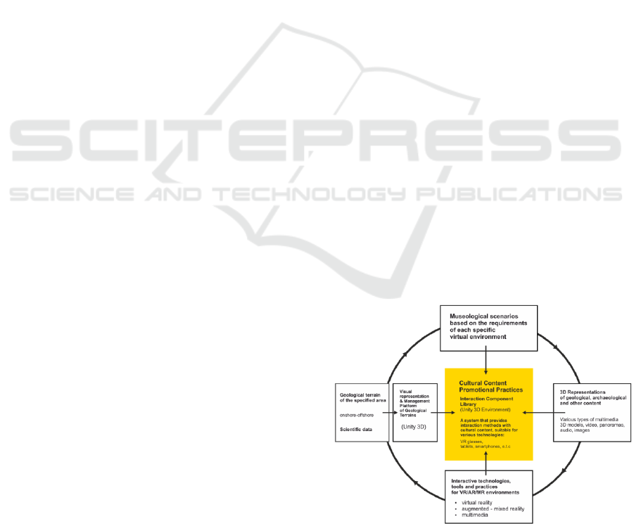
2.1 VIRTUALDIVER Framework
VIRTUALDIVER platform is a unified design
solution for developing interactive experiences for
the cultural and tourism sector. The platform
integrates cutting edge VR and AR technologies
combined with a designer-friendly multimedia
management workflow methodology as a toolkit for
building and visualising interactive narratives.
Figure 1: The overall structure of the developed
VIRTUALDIVER framework.
GISTAM 2020 - 6th International Conference on Geographical Information Systems Theory, Applications and Management
8
As a specialized product, VIRTUALDIVER will aim
to support and boost specific forms of tourism such
as: cruise tourism, diving, science tourism and more.
The development of the platform is based on the
collaboration of scientists from different scientific and
engineering fields with the ultimate goal of creating
interactive experiences through an interdisciplinary
and transdisciplinary design process.
The design team of the VIRTUALDIVER
platform consists of a core of researchers from the
following scientific fields:
Scientific disciplines that study geology,
oceanography and remote sensing.
Humanities with an emphasis on culture
(museology, archaeology, history, etc.)
Scientific/ artistic disciplines that study
design, filming, script writing, sound and
visual arts on a theoretical and practical level.
Scientific disciplines that study geomatics,
information and communication technologies.
Other scientific fields that can make a useful
contribution, depending on the use case
scenario.
VIRTUALDIVER platform will be available as
a provided service from the project’s consortium.
The project’s goal is to shape a new unique tourism
product internationally, promoting the enormous
onshore and offshore cultural reserve of Greece. In
addition, it will raise the value of the platform’s
clients (municipalities, ministries, cultural
institutions, etc.) and bring increased revenue to the
region of application.
2.2 Multimodal Mapping for VR
More specifically, capturing of real-world scenes in
3D models for the visualization in VR is based on a
multimodal Mapping Methodology: i) a
methodology and the system of acquiring
heterogeneous-bathymetric, visual and multi-
spectral data; ii) an innovative Structure-from-
Motion approaches that compensate the refraction in
underwater image creation for 3D reconstruction of
small details and adopting incremental approaches to
deal with a large number of images; iii) a
combination of image processing techniques to
restore the warm colours of underwater scenes that
suffer from light absorption in water; iv) co-
registration algorithms to combine heterogeneous
data for the creation of novel texture for the
reconstructed 3D models and photomosaics; iv)
classification of multispectral data using deep learn-
ing algorithms for recognizing geological materials
and create new synthetic texture for seabed models.
In particular, the data acquisition is based on
high-resolution bathymetric systems (multibeam
systems) for the larger part of the seafloor, and to
RemotelyOperated underwater Vehicles (ROV) and
Unmanned Aerial Vehicles (UAV) for the
acquisition of the more detailed visual and
multispectral data. These latter can accurately
capture the volcanic geomorphology and the steep
internal slopes of Santorini’s caldera, as well
cultural heritage details The 3D Virtual
Representations (single elevation model, 3D detailed
photo-textured models and geological maps) will be
of high-resolution, but simplified geometric
structure in order to constitute the detailed
background of the Interactive Platform for the
implementation of Virtual Experiences (Fig.1).
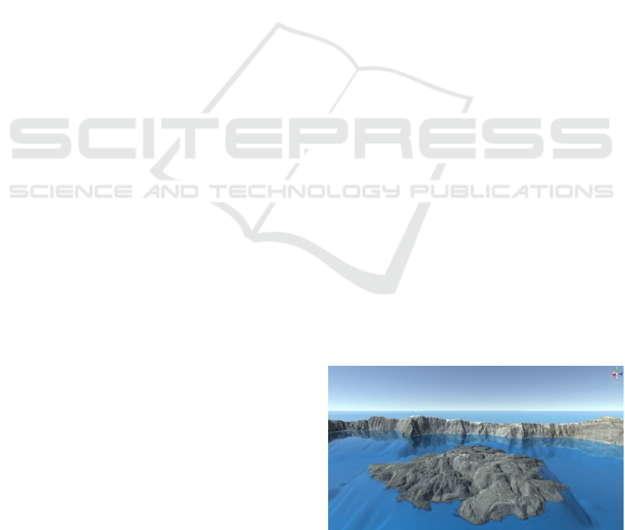
Aiming to a both photorealistic and accurate
digital representation of the Santorini’s terrain in a
VR environment, our team have developed a robust
and fast workflow to capture, integrate and combine
geospatial data of different modalities. The proposed
methodology initially considers the needs of the user
and the essential characteristics of the desired
geospatial background, the 3D models on it and the
other required figurative products. Existing
geospatial data were also exploited. In particular,
bathymetric data (Nomikou et al., 2014; 2016; Hooft
et al., 2017) and imagery from ROV missions
(Carey et al., 2013; Camilli et al., 2015), both
provided by previous works of the team, and open
source data as well (EMODnet data) were used for
the off shore 3D model. Regarding the on shore,
SRTM, satellite imagery from the WorldView4 and
LIDAR data describing Kameni Island were
combined (Nomikou et al., 2014). The mentioned
dataset was exploited in order to create a truly
detailed and of high accuracy 3D model of Santorini
Island which later was processed in Unity3D (Fig. 2).
Figure 2: WorldView4 imagery of Santorini volcano
combined with surface data.
Novel Virtual Reality Solutions for Captivating Virtual Underwater Tours Targeting the Cultural and Tourism Industries
9
Innovative methods were developed for drone
imagery collection and processing was applied and
ROV missions with top-notch camera equipment are
on-going. This will lead to a more accurate 3D
reconstruction of high interest scenes. In addition to
this, GNSS measurements provide the necessary
georeference of the 3D models and later will assist
the matching between the Points of Interest in real
world and the VR environment. Finally, panoramic
images and videos add a rather realistic point of
view for the User into the VR environment.
The methodology developed by our team
consists of three main steps. Initially, bathymetric
and SRTM data were scaled down to meet the
smallest resolution of our dataset (LIDAR).
Afterwards, the elevation data were combined based
on the slope of the relief which also considers a
buffer area aiming to a smoother terrain. Although
this minimizes the spikes and the steep effects on the
terrain, it can lead to ambiguities, so particular
attention is required. Finally, the surface data and
the WorldView4 imagery are combined applying the
well-known nearest neighbour matching technique
leading to the final terrain background (Fig. 3).
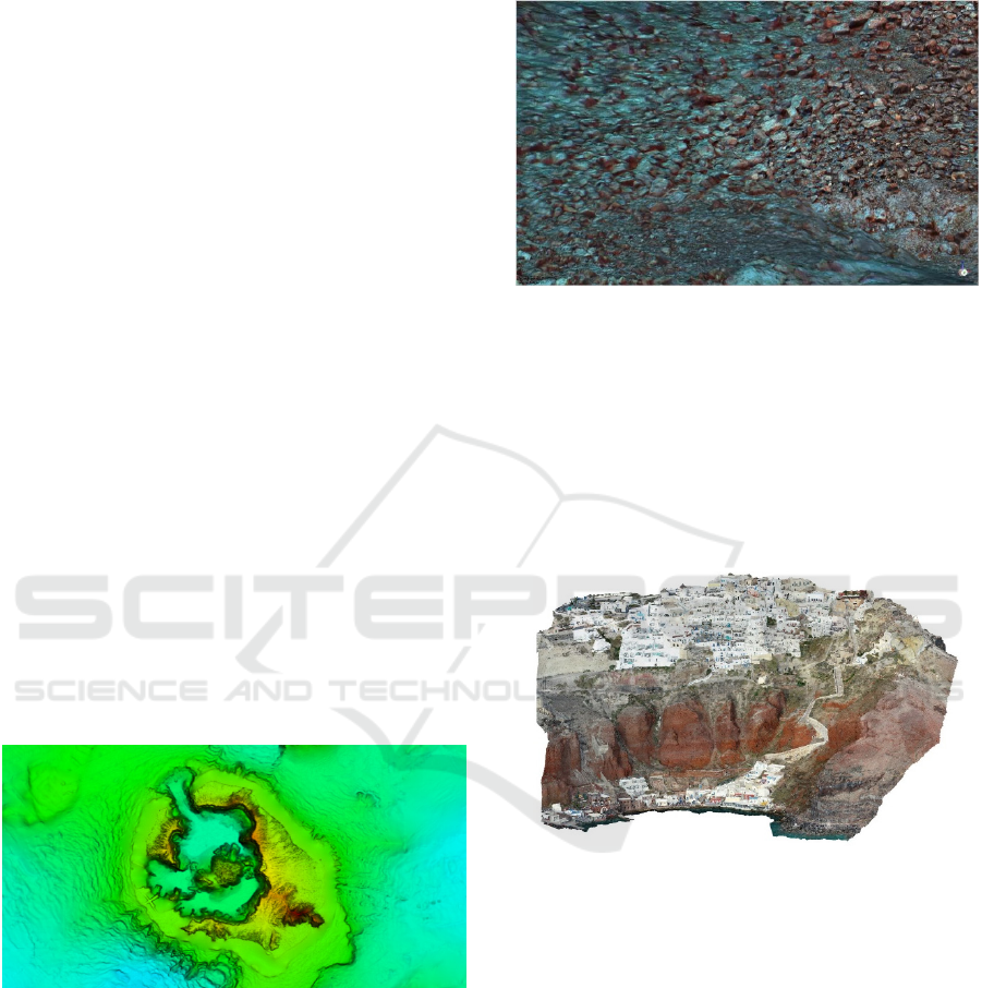
Subsequently, images captured by drone and
ROVs using open-source 3D reconstruction software
(Colmap, Meshroom), combined with custom
algorithms, were processed. The result is exceptional
and gives a detailed representation of parts of the
island’s points of interest (Figs 4 and 5). Panoramic
views and videos complete the visual representation
of the Santorini Island.
Figure 3: Combined of bathymetric, LIDAR and SRTM
data of Santorini volcano.
In VIRTUALDIVER, the platform is being
developed on the Unity 3D technology, one of the
most widespread platforms for designing,
development, and implementation of interactive 3D
environments, and will consist of two interconnected
systems:
(i) management of 3D terrains and their relevant
metadata
Figure 4: 3D reconstruction of ROV images from
Santorini’s seafloor.
(ii) implementation of narrative scenarios. The goal
is the management unit of the 3D terrains to be able
to import and manage single seabed and terrestrial
topography, while subsequently the interactive
platform will be able to provide a series of specially
developed tools aiming for a designer’s friendly
workflow of VR interactive experiences production.
Figure 5: 3D reconstruction of Oia village at the northern
part of Santorini volcano.
VIRTUALDIVER aims to: i) provide massive
development and dissemination of virtual
experiences of coastal and underwater space by
creating a composite digital Interaction Platform, ii)
differentiate the product in relation to the
international standards, and iii) promote the
underwater environment and innovative
technologies as essentials to map the coastal and,
above all, the marine space, enhancing experiences
through the geological interpretation of the volcanic
relief of Santorini.
GISTAM 2020 - 6th International Conference on Geographical Information Systems Theory, Applications and Management
10
3 INTERACTIVE PLATFORM
DEVELOPMENT
3.1 Defining Functional and Technical
Specifications of the
VIRTUALDIVER Platform
The functional requirements of the end users of
Virtual Experience have been recorded and analyzed
based on international experience, the Companies’
experience in related projects, and the Advisory
Committee's view. Within this frame, the
expectations of the User related to his virtual
Tourism-Cultural interests and the forms of
interaction that are currently available with Virtual
and Enhanced Reality devices have been recorded.
The technical specifications of the Interaction
Platform and the Geomorphological Mapping
System and 3D Visualization System have been
determined. In this delivery, one-to-one operational
requirements of the Functional and Technical
Specifications of the Platform have been met, as
well as the technical requirements for accurate and
spatial data analysis, interaction files connecting the
work packages, device capabilities, etc.
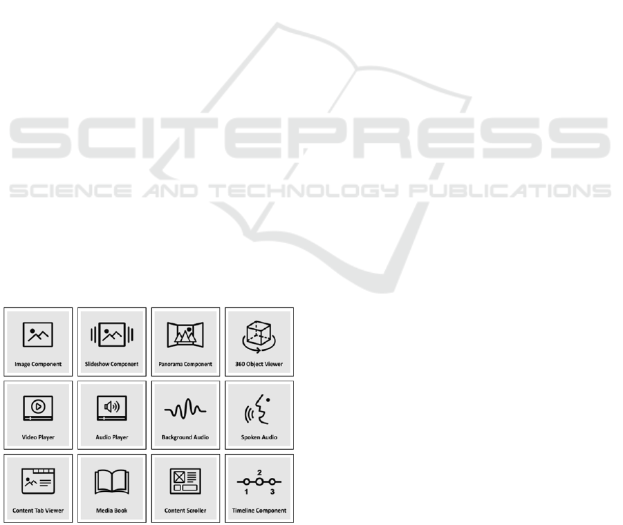
As far as the VIRTUALDIVER Interaction
platform is concerned, it will be developed using the
Unity Real-Time Development Platform and will act
as an add-on for the platform dedicated for
developing interactive experiences. Taking advantage
of Unity’s capabilities, a series of interaction
components will be developed, each with a different
approach of handling multimedia content. Depending
on the requirements and limitations of the interactive
experience that needs to be created, a series of
interaction components will be available (Fig. 6).
Figure 6: The proposed interaction components of the
VIRTUALDIVER framework.
These components will act as tools for the
authors (the design team) of the Interaction
Platform, that will facilitate the creation of diverse
interactive narratives. The key factor of our
proposed methodology is the simplification of
complex development workflows, without the need
of any specialized programming knowledge. Based
on a designers’ centric workflow approach, our
proposed methodology advances the
interdisciplinary collaboration among scientists and
experts from diverse scientific fields with different
backgrounds.
At the current stage of development, the
methodology and design principles for the creation
of a series of interaction components have been set.
Despite that, the requirements of the case study will
determine which interaction components will be
prioritized for development and implemented for a
fully immersive Virtual Reality experience. In future
stages of the platform, the implementation of
interaction components with similar characteristics
in an Augmented Reality environment will be
examined.
3.1.1 Planning and Collection of
Heterogeneous Data
Planning and collection of heterogeneous seafloor,
coastal and onland data (ROV, UAV). The main
data is multi-spectral and RGB, and at the same time
other receivers for georeferencing and mapping of
heterogeneous file data (EMODNET data,
Copernicus Marine Services, etc.) have been
deployed as well as geological data.
3.1.2 Website
For the dissemination and publicity needs of
VIRTUALDIVER, an appropriate Project Website
has been created, to promote the activities and
outputs of the project (www.virtualdiver.gr) and also
all public deliverables. Additionally, website will
communicate directly a Twitter, Slideshare and
Facebook page, using the “Network Publisher”
plugin for WordPress.
3.2 User Interface Design
The interactive components were complimented
with a set of UI designs that promote simplicity and
ease of use. The goal was to give the design team a
familiar User Interface to work with in order to
create seamless interactive narratives. The same
design principles were applied to all the interactive
Novel Virtual Reality Solutions for Captivating Virtual Underwater Tours Targeting the Cultural and Tourism Industries
11
components (visual and functional consistency)
providing thus a unified experience for the design
team (Fig. 7). Concerning the end users’ needs and
requirements, a set of UI designs was implemented,
based on best practices for VR User Interface design
combined with academic research from the HCI
field specialized in VR application development.
Figure 7: The pop-up interaction component as used by
the design team within the Unity Editor environment.
Based on research literature concerning head
movement and hand usage in VR (Alger, 2015;
Applebee, 2016; Chu, 2014; Oculus, 2015), a set of
ergonomic interaction rules was defined, thus
making the overall VR experience more
comfortable. Based on those design rules, an
interactive tool bar was designed and developed that
makes it easier and more intuitive for the user to
explore interactive multimedia content and navigate
between narratives (Fig. 8).
Figure 8: Interacting with multimedia content using the
interactive tool bar.
3.2.1 Creation of Geo-Ecotourism Scenarios,
Educational Material and Productions
and Their Interconnection through the
Interactive Platform
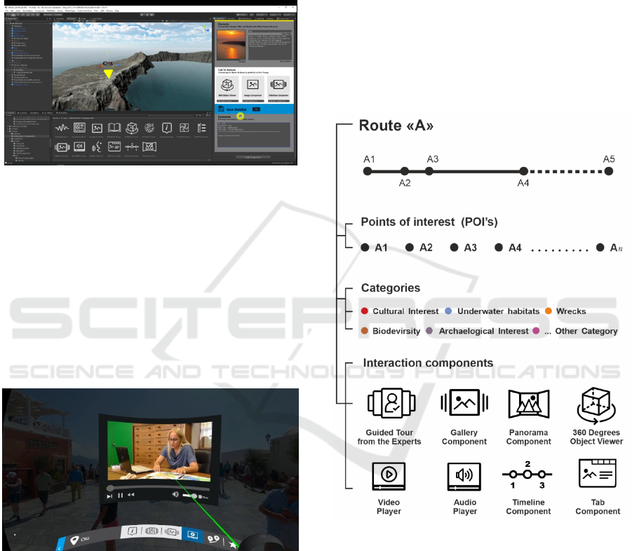
Narrative scenarios, multimedia educational material
for selected points of interest, and a series of
audiovisual products are being created to be used to
produce interactive experiences. Each scenario in the
VIRTUALDIVER platform consists of a number of
points of interest, categorized according to their
characteristics such as: tourist interest, geological
interest, marine ecosystem, archaeological site, etc.
To illustrate each point of interest, the design team
will be able to use a range of interaction components
for the exploitation of multimedia content, each of
which will correspond to a different type of data
(e.g. image, audio, video, panoramic images and
videos, 3D objects, use of 360 video footage,
panoramic and drone photos, 3D animation,
interactive maps, interactive timelines, explanatory
interactive diagrams, specially designed
soundscapes, etc (Fig. 9).
Figure 9: Points of Interest, categories and narrative tools.
4 DISCUSSION AND
CONCLUSIONS
VIRTUALDIVER intends to promote technical and
financial constraints on the creation of Virtual
Experiences in the exciting submarine world, in
order to be an attractive entertainment and cultural
product that will be deployed by tourism and
cultural institutions in Greece. The proposed
approach concerns the development of an Interaction
GISTAM 2020 - 6th International Conference on Geographical Information Systems Theory, Applications and Management
12

Platform that will simplify the process of
implementing the Integrated Virtual Experience -
narrative scenarios, audio-visual productions and
educational material – on the one hand for non-
experts and, on the other hand, the creation of
geospatial backgrounds and 3D visual information.
The Interaction Platform will be fed by the
innovative Mapping System and 3D visualization of
submarine areas with an emphasis on the
interpretation of geological/geomorphological
structures and the spatial connection to the coastal
area for the needs of Virtual and Extensive
Navigation. The digital platform is based on the
unique, complex and extremely interesting volcanic
area of Santorini, which is of great value as a tourist
product.
The contribution of VIRTUALDIVER to the
sector of "Tourism, Culture and Creative Industries"
is crucial, as it addresses private (or non) operators
with an innovative B2B service in order to boost
their commercial value through the creation of a
unique tourist product - experience of impressive
virtual environments. Moreover, it will establish a
new approach to promoting the cultural and
environmental supplies through enhancing special
forms of tourism. Regarding the underwater
environment, which is hardly accessible to the
average visitor in Greece, VIRTUALDIVER will
serve as a mediator for the perception of this
particular aspect of the world that surrounds us.
ACKNOWLEDGEMENTS
This research has been co‐financed by the European
Union and Greek national funds through
the Operational Program Competitiveness,
Entrepreneurship and Innovation, under the call
RESEARCH – CREATE – INNOVATE (project
code T1EDK-02210).
REFERENCES
Alger, M. (2015) Visual Design Methods for
Virtual Reality [online] Available at Internet:
http://aperturesciencellc.com/vr/VisualDesignMethods
forVR_MikeAlger.pdf [2019-08-28]
Applebee, A. (2016) Virtual reality: Templates for UI
design in VR [online] Available at Internet:
https://blog.kickpush.co/beyond-reality-first-steps-
into-the-unknown-cbb19f039e51
Camilli R., Nomikou P., Escartín J., Ridao P., Mallios A.,
Kilias S.P., Argyraki A. and the Caldera Science Team
(2015). The Kallisti Limnes, Carbon Dioxide-
Accumulating Subsea Pools. Scientific Reports,
3:2421.
Carey S., Nomikou P., Croff Bell K., and Ballard D.
(2013). Exploration of the Santorini volcanic group,
southern Aegean Sea: Oceanography (Washington,
D.C.), v. 26, no. 1, supplement, p. 44–49.
Christopoulou Al., Gadolou An., Bouyia P. (2012). “The
Antikythera Shipwreck. The Technology of the ship,
the cargo the Mechanism”. Trans. M.A. Fowler,
Athens: National Archaeological Museum.
Chu, A. (2014). VR design: transitioning from a 2D to a
3D design paradigm. Presented at Samsung Developer
Conference, 19 November, 2014. Available at
Internet: https://www.youtube.com/watch?v=XjnHr_6
WSqo [2019-08-28]
Friedrich WL., Kromer B, Friedrich M, Heinemeier J,
Pfeiffer T, Talamo S. (2006). “Santorini eruption
radiocarbon dated to 1627-1600 B.C.”. Science. 2006
Apr 28;312 (5773):548.
Hooft E.E., Nomikou P., Toomey D.R., Lampridou D.,
Getz C., Christopoulou M-E., O'Hara D., Arnoux
G.M., Bodmer M., Gray M., Heath B.A., VanderBeek
B.P. (2017). Backarc tectonism, volcanism, and mass
wasting shape seafloor morphology in the Santorini-
Christiana-Amorgos region of the Hellenic Volcanic
Arc. Tectonophysics 712–713 (2017) 396–414.
Mahon I., Pizarro O., Johnson-Roberson M., Friedman A.,
Williams S.B., Henderson J.C. (2011).
“Reconstructing Pavlopetri: Mapping the World’s
Oldest Submerged Town using Stereo-vision”. 2011
IEEE International Conference on Robotics and
Automation Shanghai International Conference
Center.
Nomikou P., Carey S., Papanikolaou D., Croff Bell K.,
Sakellariou D., Alexandri M., Bejelou K. (2012).
“Submarine Volcanoes of the Kolumbo volcanic zone
NE of Santorini Caldera, Greece”. Global and
Planetary Change 90-91, 135-151.
Nomikou, P., Parks M., Papanikolaou D., Pyle D., Mather
T., Carey S., Watts A., Paulatto M., Kalnins M.,
Livanos I., Bejelou K., Simou E., Perros I. (2014). The
emergence and growth of a submarine volcano: The
Kameni islands, Santorini (Greece). GeoResJ., Vol.1,
8-18.
Nomikou P., Druitt T.H., Hubscher C., Mather T.A.,
Paulatto M., Kalnins L.M., Kelfoun K., Papanikolaou
D., Bejelou K., Lampridou D., Pyle D.M., Carey S.,
Watts A.B., Weib B. & Parks M.M. (2016). “Post-
eruptive flooding of Santorini caldera and implications
for tsunami generation”. Nature Communications,
7:13332, DOI: 10.1038/ncomms13332.
Oculus VR (2015) User input and navigation. Oculus best
practices. Available at Internet: https://pdfs.
semanticscholar.org/0d8b/1d9d32bebdc79143f07ad67
3d97dac230cfe.pdf [2019-08-28].
Novel Virtual Reality Solutions for Captivating Virtual Underwater Tours Targeting the Cultural and Tourism Industries
13
