
Approach using the Internet of Things in the Sahel for Smart Irrigation
Fatoumata Thiam
1
and Cheikhou Thiam
2
1
Universit
´
e Gaston Berger Saint-Louis, Senegal
2
Universit
´
e de Thi
´
es, Thi
´
es, Senegal
Keywords:
Internet of Things, Irrigation, Artificial Intelligence.
Abstract:
Nowadays the Internet of Things (IoT) is used in many sectors such as health, military, industry, agriculture
and so on. This technology is considered as a special type of ad hoc network and one of these promising areas
is precision farming where it can provide important support that will facilitate agricultural practices and that
can modernize and replace some of the traditional techniques. In Sahelian area, water is a critical resource due
to short rainy seasons and waste of water in gross irrigation. The main activity in the Niayes area is market
gardening. Urgent measures must be taken to save water reserves during the long dry season. Smart irrigation
can be a solution for water wastage problem. Many techniques have been developed to solve these problems.
In this paper, we can find techniques based on evapotranspiration (ET), Soil Water Assessment Tool (SWAT)
and Internet of Things (IoT). This paper aims to propose a solution of smart irrigation based on IoT.
1 INTRODUCTION
In recent years, with the evolution of technology, the
emergence of a new internet of things information
network called the Internet of Things , which is con-
sidered as a special type of ad hoc network whose
nodes are sensors able to harvest and transmit envi-
ronmental data in an autonomous way. The nodes are
randomly dispersed across a geographic area, called
the catchment field, which defines the area of interest
for the captured phenomenon. The captured data is
routed to a node considered a data collection place,
called sink node. The latter can be connected to the
network user via the Internet or a satellite. Thus, the
user can address requests to the other nodes of the
network, specifying the type of data required and har-
vest the environmental data captured through the well
node. Internet applications of objects are numerous.
They include different fields: agricultural, health, ...
etc. The intelligent irrigation system is an IoT-based
device that is able to automatically deactivate the mo-
tor pump once the soil moisture sensor has reached
the required threshold value. There is a growth in
agricultural products via the Internet of Things. This
solution is a response to the problems of environmen-
tal change in the Sahel and has a significant impact on
the agricultural economy.
Population grows at an exponential rate and feed-
ing people is progressively being problematic. Ex-
tra food needs to be produced. People are building
more and agricultural land are being occupied also,
the use of water has significantly increased. Valuable
land and water resources required for food production
have become critical.
An urgent need of regulating water utilization is
required. In fact, decreasing water, drying of rivers,
unpredictable environment is very common. In Sahe-
lian area, water is a critical resource due to short rainy
seasons and waste of water in gross irrigation. The
main activity in the Niayes area is market gardening.
To solve that, in agriculture domain, sensors are de-
ployed at suitable locations to monitor crop growth
and water use.
In this article we propose an approach that consists
of setting up a network of sensors for intelligent irri-
gation and thus an efficient use of water. This study
will be discussing on how the precision irrigation is
implementing via many technicals. We will next see
those technicals and present some example of works.
This article is organized like following: we will intro-
duce first this study, secondly. The section 2 presents
some background concepts. Section 3 presents sev-
eral studies in the domain. In the section 4 we present
our approach for optimizing irrigation. The section 5
presents results which are the comparison of different
approaches. Finally, the last section summarizes the
contributions.
Thiam, F. and Thiam, C.
Approach using the Internet of Things in the Sahel for Smart Irrigation.
DOI: 10.5220/0009800601690174
In Proceedings of the 9th International Conference on Smart Cities and Green ICT Systems (SMARTGREENS 2020), pages 169-174
ISBN: 978-989-758-418-3
Copyright
c
2020 by SCITEPRESS – Science and Technology Publications, Lda. All rights reserved
169
2 BACKGROUND CONCEPTS
2.1 Irrigation Paradigm in the Niayes
Area
The world’s population is expected to exceed nine bil-
lion by 2050, three times more than in 1950 (Angus
and Butler, 2014)(Bricas and Seck, 2004). The prob-
lem of global food security is growing. The rural exo-
dus leads to an agglomeration form in the urban areas,
which have become in a few years the place of life, of
more than half of the population. The planet is facing
a problem of meeting the food needs of its population.
Food security in urban areas is even more worry-
ing in the cities of the South, already facing a high
rate of poverty. In this context, urban and peri-urban
agriculture (UPA) is developing, occupying an essen-
tial place in the urban food supply.
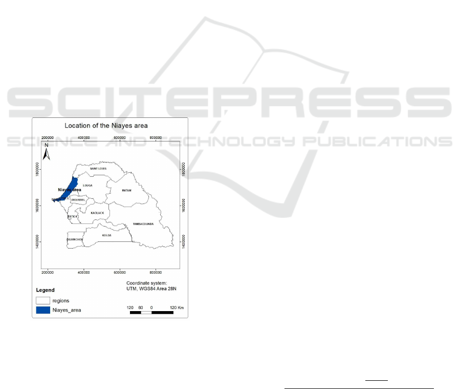
In Senegal, UPA activities are concentrated in the
Niayes area Figure 1. The Niayes is a series of small
valleys between dunes along the northern coastline
of Senegal. Since its appearance in Senegal in 1937,
market gardening has generally evolved both in terms
of surfaces used and yields. Nevertheless, the demand
is not satisfied, and Senegal continues to import veg-
etables.
Figure 1: Niaye area in Senegal (translation).
Indeed with the scarcity of rain, the main source
of water supply that constituted the semi-superficial
aquifers Niayes has shown its limits. As a result,
wastewater has become an attractive alternative for
market gardeners. However, at the bacteriological
level, the coliform and Powerful streptococci concen-
trations are well above the WHO (World Health Or-
ganization) guideline (Niang, 1996).
There are three main constraints identified by
farmers (Ba and Cantoreggi, 2018):
• land insecurity (74%);
• lack of water for irrigation (62%);
• and salinization of water and soil (27%).
In view of all these problems, a water saving solu-
tion is needed
2.2 Mathematical Models
It is important to optimize water utilization in agricul-
ture to avoid water stress in the future. The scheduling
and management of irrigation water are used to pre-
vent over-irrigation and water wastage. Many tech-
niques are based on studying the plant water require-
ment and other on mathematical model, algorithms,
etc.
Optimized-irrigation can be defined as applying
the right amount of water to the plant, to allow it to
grow without over-irrigating or under-irrigating. In-
deed, over-irrigation can lead to leaching of soil nu-
trients, while under-irrigation prevents the plant from
growing properly.
Smart-irrigation is a set of hardware and software
to automate and optimize irrigation for a good evolu-
tion of the crop. For an optimized irrigation schedule,
there are two components to consider (George, 2017):
1. Determine the crop water requirements (CWR);
2. Estimate the right time to water the plants.
To determine the CWR, there is a parameter called ET
standing for evapotranspiration. The ET is the sum of
crop transpiration and evaporation of soil water con-
tent. The CWR is the same as ET. To determine ET,
the FAO (Food and Agriculture Organization of the
United Nations) have stood two methods (Savva and
Frenken, 2002) :
• Fao Penman-Monteith method is an equation that
require climate parameters to determine the ET
0
;
• Pan evapotranspiration is a measurement that uses
a pan evaporimeter and parameters like wind
speed, humidity, temperature and the sunshine to
calculate the ET
0
.
ET
0
is the evapotranspiration used as reference to cal-
culate other crops ET wich is ET
c
equation 1. The
reference crop used for ET
0
is grass.
Fao Penman-Monteith equation.
ET
0
=
0.408δ(R
n
− G) + γ
900
T +273
u
2
(e
s
− e
a
)
δ + γ(1 + 0.34u
2
)
(1)
ET
0
= Reference evapotranspiration (mm/day)
R
n
= Net radistion atr the crop surface (MJ/m
2
)
SMARTGREENS 2020 - 9th International Conference on Smart Cities and Green ICT Systems
170

G = Soil flux density (MJ/m
2
)
T = Mean daily air temperature at 2m height (° C)
u
2
= Wind speed at 2m hieghr (m/sec)
e
s
= Saturation vapour pressure (kPa)
e
a
= Actual vapour pressure (kPa)
The FAO Penman-monteith (Savva and Frenken,
2002) is used to determine the ET
c
and then the IR,
Irrigation requirement equation 2.
IR = ET
c
− (Pe − Ge +Wb) + LR (2)
IR= Irrigation Requirement (mm)
ET
c
= Crop Evapotranspiration (mm)
Pe= effective dependable rainfall (mm)
Ge= Groundwater contribution from water table
(mm)
W b = Water stored in the soil at the beginning of each
period (mm)
LR = Leaching Requirement (mm)
It is important to distinct CWR and IR. In fact, for
an effective irrigation, more parameters like the cli-
mate, the crop type and the growth stage of the crops,
need to be taken into consideration to attain plant wa-
ter need.
2.3 Computer Simulation Model for
Natural Water Resources
Computer science helps to model efficient water use
in crop field. Powerful evaluation and simulation
tools are made to help water usage planning. To re-
flect actual values of field parameters, these models
have to fit in real time system to avoid ineffective
performance of irrigation schedule. In addition, crop
growth, depend closely to irrigation frequency and
amount of water supplied to the plants. So, it is cru-
cial to have a model to produce a good watering plan.
There are many tools used to model water use in crop
field, for example (Chen et al., 2018):
• The Soil Water Assessment Tool (SWAT) for wa-
tershed scale model, used to simulate the quality
and quantity of surface and ground water and pre-
dict the environmental impact of land use, land
management practices, and climate change.
• MODFLOW wich is a program used by hydro-
geologists to simulate the flow of groundwater
through aquifers.
• Decision Support System for Agrotechnology
Transfer (DSSAT) is software application pro-
gram that comprises dynamic crop growth simu-
lation models for over 40 crops.
SWAT model is widely used for managing water re-
sources.
2.4 Internet of Things - IoT
ICTs has a significant impact on the concept of smart
agriculture. Smart-agriculture is the use of computer
devices, in the farming process to optimize usage of
natural resources, limit human labor and have a good
profitability.
The Internet of Things (IoT), in particular Wire-
less Sensor Networks (WSN) is commonly used in
Smart-agriculture. WSN is a collection of physical
modules called sensors to capture, process and trans-
mit information in the environment in which they are
deployed. Sensors are deployed at different soil depth
to sense water flow and help to determine proper time
for water supply. Based on IoT, SMART-Irrigation
can help for water wastage problems, over-irrigation
that can lead to the leaching of nutrients and slowing
down crop growth (George, 2017). Precise irrigation
is a concept of saving water supply to use exactly the
exact amount of water for the plant to develop cor-
rectly. Many parameters are taken in account to define
a precise irrigation. Some of them are meteorological
data like temperature, humidity, the wind, etc. Some
of those can be obtained by using sensing elements
like soil moisture sensors.
3 RELATED WORK
SMART-Irrigation is the use of technology in the
farming process to automatize certain procedures and
increase yields. Sensor devices are linked by wireless
communication technology to monitor data from the
agricultural field. Many studies are focused on using
soil moisture sensors to determinate water supply or
to determine when to irrigate. In the following we
will see some work on Smart-irrigation.
CROPWAT(Savva and Frenken, 2002) is a soft-
ware that can calculate CWR and IR from climatic
and crop data in a particular area. Various tables are
given to estimate the exact value of each parameter of
the Penman-Monteith equation. Meteorological sta-
tions are distributed all through a given country mak-
ing it possible to prepare reference crop evapotran-
spiration maps for a country. Those meteorological
stations are contained in CLIMWAT wich is a soft-
ware that help to obtain value of each parameter of
the Penman-Monteith equation. I
In (Chen et al., 2018), authors created a SWAT
based algorithm. The algorithm simulates manage-
ment allowed depletion (MAD) irrigation schedul-
Approach using the Internet of Things in the Sahel for Smart Irrigation
171
ing by taking in an allowable depletion percentage of
plant available water (PAW). The algorithm also sus-
pends irrigation events after harvest. Weather data are
acquired from the nearby meteorological observation
post. They are then compiled into daily values and
formatted for model input.
In (Myers et al., 2017), the developed system uses
real-time sensor data, weather forecasts, geological
and environmental information to infer the precise
amount of water needed to minimize wastage without
compromising the health and wellbeing of the lawn or
garden. The water supply in the yard is automatically
managed by sensor-actuator nodes, based on seman-
tic inference. The combination of data from multiple
sources with a sensor-actuator system helps to pro-
vide precise irrigation.
In (Mohanraj et al., 2017), the proposed system
automates the irrigation and fertigation using WSN to
detect rainfall intensity. The system is integrated with
irrigation module which uses Penman-Monteith FAO-
56 equation for calculating crop water need. There
are four functionalities carried out by end nodes: es-
timation of CWR, calculation of irrigation period, de-
tection of water discontinuity and monitoring the re-
maining energy of the battery.
Studies have identified insufficiencies in the auto-
irrigation algorithms in the Soil and Water Assess-
ment Tool (SWAT). It is noted a continuation of ir-
rigation during the non-growing period and incapa-
bility to simulate growth stage specific irrigation. The
CROPWAT program produces a watering calendar for
all the growing season of the crops once. That type of
configuration may not take in account some climatic
change like rain, slopes or unexpected dryness.
In the following part we are aiming to present our
solution of smart-irrigation wich will consider evap-
otranspiration and real time monitoring plant water
need for a precise irrigation.
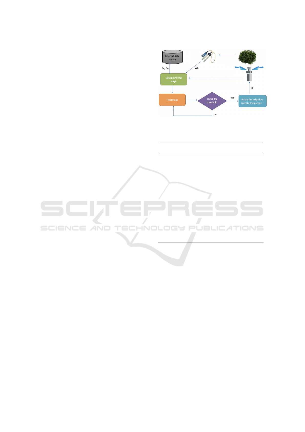
4 APPROACH
In our proposal, a set of soil moisture sensors are de-
ployed over the land to monitor soil water content.
Then based on defined thresholds, IR (Irrigation Re-
quirement) will be calculated to determine water sup-
ply, in addition of a set of external data sources. The
system should be able to adapt watering plan through
artificial intelligence function. Parameters like effec-
tive dependable rainfall (Pe) and groundwater contri-
bution (Ge) (Figure 2) will be acquired from external
data sources (OpenWeatherMap.org, ) (wea, ).
Our system will consist of soil moisture sensors,
actuators and sprinklers nodes. The sensors measure-
Figure 2: Flow diagram.
Table 1: Crop evapotranspiration for tomato crop in Niayes
area, Saint-Louis (coef=coefficient).
Month Decade Stage
Kc
coef.
Etc
mm/day
Etc
mm/decade
Oct 3 Init 0.60 3.11 2.8
Nov 1 Init 0.60 3.20 0.2
Nov 2 Init 0.60 3.28 0.0
Nov 3 Deve 0.66 3.55 0.0
Dec 1 Deve 0.81 4.34 0.2
Dec 2 Deve 0.96 5.12 0.2
Dec 3 Deve 1.13 6.20 0.3
Jan 1 Mid 1.22 6.95 0.4
Jan 2 Mid 1.22 7.19 0.5
Jan 3 Mid 1.22 7.45 0.5
Fev 1 Mid 1.22 7.71 0.6
Fev 2 Late 1.20 7.86 0.7
Fev 3 Late 1.11 7.55 0.5
Mar 1 Late 1.01 7.18 0.2
Mar 2 Late 0.92 6.77 0.0
ments will be sent to the system. These data will then
be combined with evapotranspiration data of the ac-
tual area to serve as an input to our system.
During data gathering and modelization (Figure
3), the system collects raw data from various sources.
The sensor network will measure the water kept in the
soil before irrigation (Wb). The modelization part,
raw data are annotated then integrated. We will use
CROPWAT’s generated data tables (Table 1) to have
the crop evapotranspiration value (ET
c
). These data
are organized in a model to become a state context of
a section of the field. The processing phase will
receive the integrated data from the precedent stage.
During this phase, reasoning is applied on these inte-
grated data to infer an efficient irrigation schedule for
each section of the field. For the reasoning, a rule-
based engine can be utilized.
SMARTGREENS 2020 - 9th International Conference on Smart Cities and Green ICT Systems
172
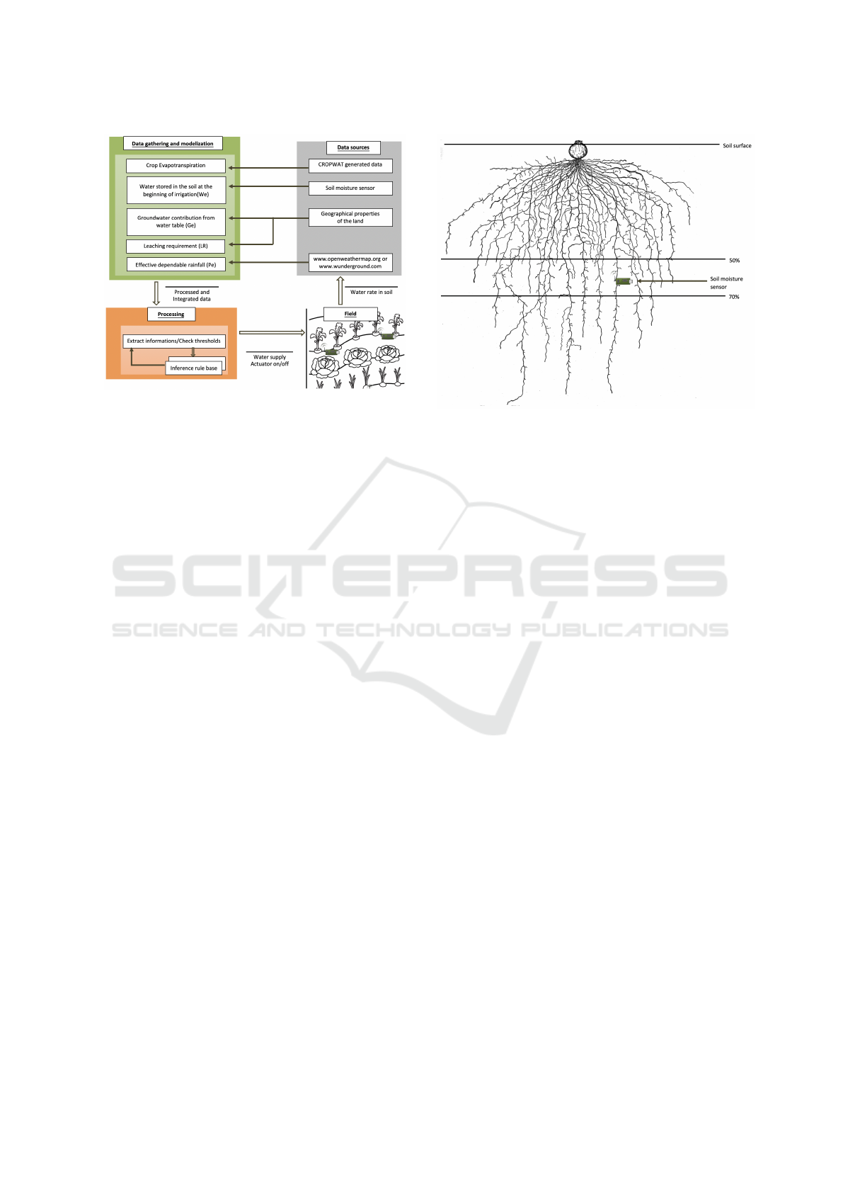
Figure 3: Functioning architecture.
5 RESULT
We develop an adaptive and a contextual system to
automate and optimize irrigation. Based on that, an
adapted water supply is applied through the irriga-
tion system. As a result, the watering system will use
strict water quantity to allow the crop to grow prop-
erly. This output will be used to make a set of infer-
ence rules to adjust the water supply and optimize it.
In the processing phase, the output of the mod-
elization phase is used to create inference rules for
a more effective irrigation that will help predict wa-
tering plan when there is a fault in our system. The
system monitors the intensity of the rain, the over-
flow due to a malfunction of the drip setup, to stop
the watering pump.
The sensor location in soil will be determinated by
the plant root zone. The Management Allowed Deple-
tion or MAD is the highest amount of water in plant
root zone that can be taken of. This amount depends
on many factors like the plant type, soil properties or
exposition of the land toward the sun wich is more
surfaces for evaporation. The value is estimated be-
tween 50% to 70% in plant root zone. Placing our
sensor in that point can contribute in optimization of
our irrigation plan Figure 4.
Our proposition is comparative to a real-time sys-
tem. In fact, the water need depend on actual state
of the soil. Rain, overflood, dysfunctioning sprinkler
or a continuous watering is automatically detected by
sensors and relayed to the system. Each sensor can be
located and if any issue, an action is made to cut off
actuators in this area.
Figure 4: Onion bulb root system.
6 CONCLUSIONS
Gross irrigation in Niayes area affects water resources
a lot. In addition of climatic changes, rainy seasons
are short. That causes water depletion in this area.
In this paper, we tried to show techniques used for
smart irrigation. We have looked at some examples
that uses mathematical models, application programs
and sensing devices to determine water use and water
need of crops.
Technology has contributed a lot in solutions of
water scarcity problem. In agriculture irrigation sys-
tems are progressively controlled by technology. To
monitor water use, devices like soil moisture sensors
help a lot in that point. Data gathered are integrated
to help make decision and adjust watering plans.
We presented a proposition of smart-irrigation.
Based on using sensors and exploiting advantages
given by FAO Penman-Monteith formula to get cer-
tain data like plant evapotranspiration. In the future
of our work we’ll compare our system with an another
that ties up to our work.
REFERENCES
Weather data packages.
Angus, I. and Butler, S. (2014). Une plan
`
ete trop peupl
´
ee?.
Le mythe populationniste, l’immigration et la crise
´
ecologique.
´
Ecosoci
´
et
´
e (
´
Editions).
Ba, A. and Cantoreggi, N. L. (2018). Agriculture urbaine
et p
´
eriurbaine (aup) et
´
economie des m
´
enages agri-
urbains
`
a dakar (s
´
en
´
egal). International Journal of En-
vironment, Agriculture and Biotechnology, 3(1):195–
207.
Approach using the Internet of Things in the Sahel for Smart Irrigation
173

Bricas, N. and Seck, P. A. (2004). L’alimentation des villes
du sud: les raisons de craindre et d’esp
´
erer. Cahiers
Agricultures, 13(1):10–14.
Chen, Y., Marek, G. W., Marek, T., Brauer, D. K., and
Srinivasan, R. (2018). Improving swat auto-irrigation
functions for simulating agricultural irrigation man-
agement using long-term lysimeter field data. Envi-
ronmental Modelling & Software, 99:25–38.
George, B. A. (2017). Technical manual for ”crop water
requirements and irrigation scheduling”.
Mohanraj, I., Gokul, V., Ezhilarasie, R., and Uma-
makeswari, A. (2017). Intelligent drip irrigation and
fertigation using wireless sensor networks. In Techno-
logical Innovations in ICT for Agriculture and Rural
Development (TIAR), 2017 IEEE, pages 36–41. IEEE.
Myers, T., Mohring, K., and Andersen, T. (2017). Se-
mantic iot: Intelligent water management for efficient
urban outdoor water conservation. In Joint Interna-
tional Semantic Technology Conference, pages 304–
317. Springer.
Niang, S. (1996). Utilisation des eaux us
´
ees domestiques en
mara
ˆ
ıchage p
´
eriurbain
`
a dakar (s
´
en
´
egal). Science et
changements plan
´
etaires/S
´
echeresse, 7(3):217–223.
OpenWeatherMap.org. Weather api.
Savva, A. P. and Frenken, K. (2002). Crop water require-
ments and irrigation scheduling. FAO Sub-Regional
Office for East and Southern Africa Harare.
SMARTGREENS 2020 - 9th International Conference on Smart Cities and Green ICT Systems
174
