
Improving the Usability of the Land Cover and Use Information System
of Spain (SIOSE): A Proposal to Distribute New Thematic Layers and
Predefined Reclassifications
Benito Zaragoz
´
ı
1 a
, Jos
´
e Tom
`
as Navarro-Carri
´
on
2 b
, Jes
´
us Javier Rodr
´
ıguez-Sala
3 c
,
Sergio Trilles
4 d
and Alfredo Ram
´
on-Morte
2 e
1
Departament de Geografia, Universitat Rovira i Virgili, C/Joanot Martorell, Vilaseca, Spain
2
Instituto Interuniversitario de Geograf
´
ıa, Universidad de Alicante, C/ San Vicente s/n, Alicante, Spain
3
Centro de Investigaci
´
on Operativa, Universidad Miguel Hernandez de Elche, Av. de la Universidad, Elche, Spain
4
Institute of New Imaging Technologies, Universitat Jaume I, Av. Vicente Sos Baynat s/n, Castell
´
on de la Plana, Spain
Keywords:
Land Use, Land Cover, Geodatabase, Object-oriented, Siose.
Abstract:
Information on land use and land cover (LULC) is fundamental in the study and planning of human activities.
In recent years, accessibility to quality geographical information has significantly increased, and this is also
true for the case of LULC datasets. In Spain, the Land Cover and Use Information System of Spain (SIOSE) is
concerned with harmonising access to this type of information through an object-oriented model and a series
of technical specifications that regional administrations must follow. However, the information from SIOSE is
so rich and complex that there is a usability gap that makes this data not exploited to its full potential in some
contexts. In this communication, we analyse the context in which this usability gap occurs, its causes and
consequences. Among other possible improvements, we suggest that enriching the SIOSE database with new
thematic information would make its use more attractive and reduce the usability gap for less expert users. We
propose an extension to the SIOSE object-oriented data model that will make it possible to enrich the LULC
data with new data that are useful for various types of studies.
1 INTRODUCTION
The information on land use and land cover (LULC)
is essential for the planning of human activities. This
type of information has the virtue of agglutinating
biophysical information and socio-economic uses of
a territory. The design of LULC data warehouses is
more often related to the concept that geographers
have of the landscape configuration as an object of
study (Antrop, 2006), which makes them suitable for
many landscape science studies. This approach has
been applied in numerous studies that show the close
relationships between LULC and essential ecosys-
tem services (Foster et al., 2003; Polasky et al.,
2011), which casts LULC data as a strategic source
a
https://orcid.org/0000-0003-2501-484X
b
https://orcid.org/0000-0002-8718-218X
c
https://orcid.org/0000-0002-3796-0692
d
https://orcid.org/0000-0003-0557-6319
e
https://orcid.org/0000-0002-9304-0719
of information for natural resource management and
land management (Valcarcel and Casta
˜
no Fern
´
andez,
2013).
1.1 LULC Data Production in the EU
Land use information has been systematically col-
lected in Spain since the creation of the National Ge-
ographic Institute (IGN) in 1870, although initially
only as a fundamental source for the preparation of
the National Topographic Map. The development of
Geographic Information Technologies, in the second
part of the last century, promoted the creation of large
official repositories of digital geographic information
compiled through different means, such as: (1) the
digitisation of official cartographic information, (2)
the incorporation of GPS field data, (3) the interpreta-
tion of aerial photography and (4) the development
of Remote Sensing. In a broader context, the Co-
ordination of Information on the Environment pro-
gramme (CORINE) was initiated in 1985 by the Eu-
294
Zaragozí, B., Navarro-Carrión, J., Rodríguez-Sala, J., Trilles, S. and Ramón-Morte, A.
Improving the Usability of the Land Cover and Use Information System of Spain (SIOSE): A Proposal to Distribute New Thematic Layers and Predefined Reclassifications.
DOI: 10.5220/0009579502940301
In Proceedings of the 6th International Conference on Geographical Information Systems Theor y, Applications and Management (GISTAM 2020), pages 294-301
ISBN: 978-989-758-425-1
Copyright
c
2020 by SCITEPRESS – Science and Technology Publications, Lda. All rights reserved

ropean Commission in order to dynamically collect,
coordinate and structure the inventory of environmen-
tal information of the European Union. The Corine
databases and several of its programmes were taken
over by the European Environment Agency (EEA).
Among these, there is the inventory of land cover at
a 1:100,000 scale for the whole European territory.
This “Land-Cover” project (CORINE Land-Cover;
CLC) has set a global precedent (B
¨
uttner et al., 2002).
In a global scope, LULC information is used for
strategic issues within the United Nations Framework
Convention on Climate Change (1992) and the revi-
sion of the Kyoto Protocol (1998). In this context,
many users are using these data for different interests,
which has led to the development of a specific ser-
vice in Europe to meet this heterogeneous demand,
the “Copernicus Land Monitoring Service” (CLMS),
within the Global Monitoring for Environment and
Security (GMES) initiative of the European Environ-
ment Agency (EEA), which in turn depends on the
Earth Observation Program “Copernicus” of the Eu-
ropean Space Agency (ESA).
In Spain, the Ministry of Development and Eco-
logical Transition addresses the general need for
LULC data, under the legal framework of the Euro-
pean Directive INSPIRE (2007/2/CE). The National
Geographic Institute (IGN) takes the role of coordi-
nator in the management and creation of data on land
occupation according to the National Territory Occu-
pation Plan (PNOT), yielding millions of downloads
on the open data platforms of this body and of the re-
gional spatial data infrastructures. The main users of
these data are the General State Administration itself
and the regional administrations, almost always for
issues regarding agrarian policy, environmental man-
agement, urban development or cartographic elabora-
tion. Applications to projects in University research
laboratories, research officer centres and public and
private companies are also remarkable.
1.2 The Appearance of Object-oriented
LULC Classifications
Throughout the development of these programs to
produce quality LULC data, many technical and tech-
nological changes took place. In this sense, the
paradigm of hierarchical classification of LULC used
at the end of the 20th century by the CORINE Pro-
gram – and by others in the same period, such as
the “land use and land cover classification system” of
the United States Geological Survey (Anderson et al.,
1976) – showed inadequacies at the beginning of the
current century. The baseline of said limitations is
that mutually exclusive classes were often more ori-
ented to the realisation of maps than to the analy-
sis and diagnosis of reality. The need for managing
more complex and bulky data sets motivated the emer-
gence of trends aimed at applying an object-oriented
paradigm (Villa et al., 2008).
Following these trends, the EAGLE group within
the European Network of Information and Observa-
tion on the Environment (EIONET) was created to
define techniques that allow optimising the integra-
tion and harmonisation of LULC data from the of-
ficial repositories of each country at pan-European
scale (Arnold et al., 2013). EAGLE proposes an
object-oriented data model (OODM) which takes into
account standards or reference code lists, such as
Corine LC and technical specifications driven by
INSPIRE (2007/2/CE) and ISO standard 19144-2
(LCML-Land Cover Meta Language). In 2005, the
object-oriented database of the Information System
on land occupation in Spain (SIOSE), emerged as
an integrated initiative in the EIONET Network (Del
Bosque Gonz
´
alez et al., 2005). SIOSE is developed
in Spain through the PNOT, under the coordination
of the IGN and the National Geographic Information
Center (CNIG). SIOSE is backed by a data model that
conforms to INSPIRE technical specifications, and its
design follows the indications of the EAGLE group,
ensuring compatibility and comparability with pre-
existing databases such as Corine CLC90, CLC00,
Murbandy/Moland or LCCS of the United Nations
FAO.
Since there are no mutually exclusive classes,
such an object-oriented model will not incur informa-
tion losses during the labelling process, thus making
feasible to store LULC statistical observations at lev-
els of detail that hierarchical classification models are
not capable of due to its dichotomic nature (Omrani
et al., 2015). It has an impact on the economic sav-
ings in the production of data sets. The elements or
variables of the landscape are unique in their defini-
tion, which allows the possibility of obtaining cus-
tom thematic outputs, according to user needs. As
a consequence, the object-oriented approach allows
generating dynamic and extensible classifications to
respond to future needs. In addition, new types of pa-
rameters can be included in different versions of the
database without conflict with the previous data (Val-
carcel et al., 2008).
2 USABILITY IN THE SIOSE
DATABASE
Regardless of the significant advantages of applying
the object-oriented paradigm to SIOSE, the SIOSE
Improving the Usability of the Land Cover and Use Information System of Spain (SIOSE): A Proposal to Distribute New Thematic Layers
and Predefined Reclassifications
295
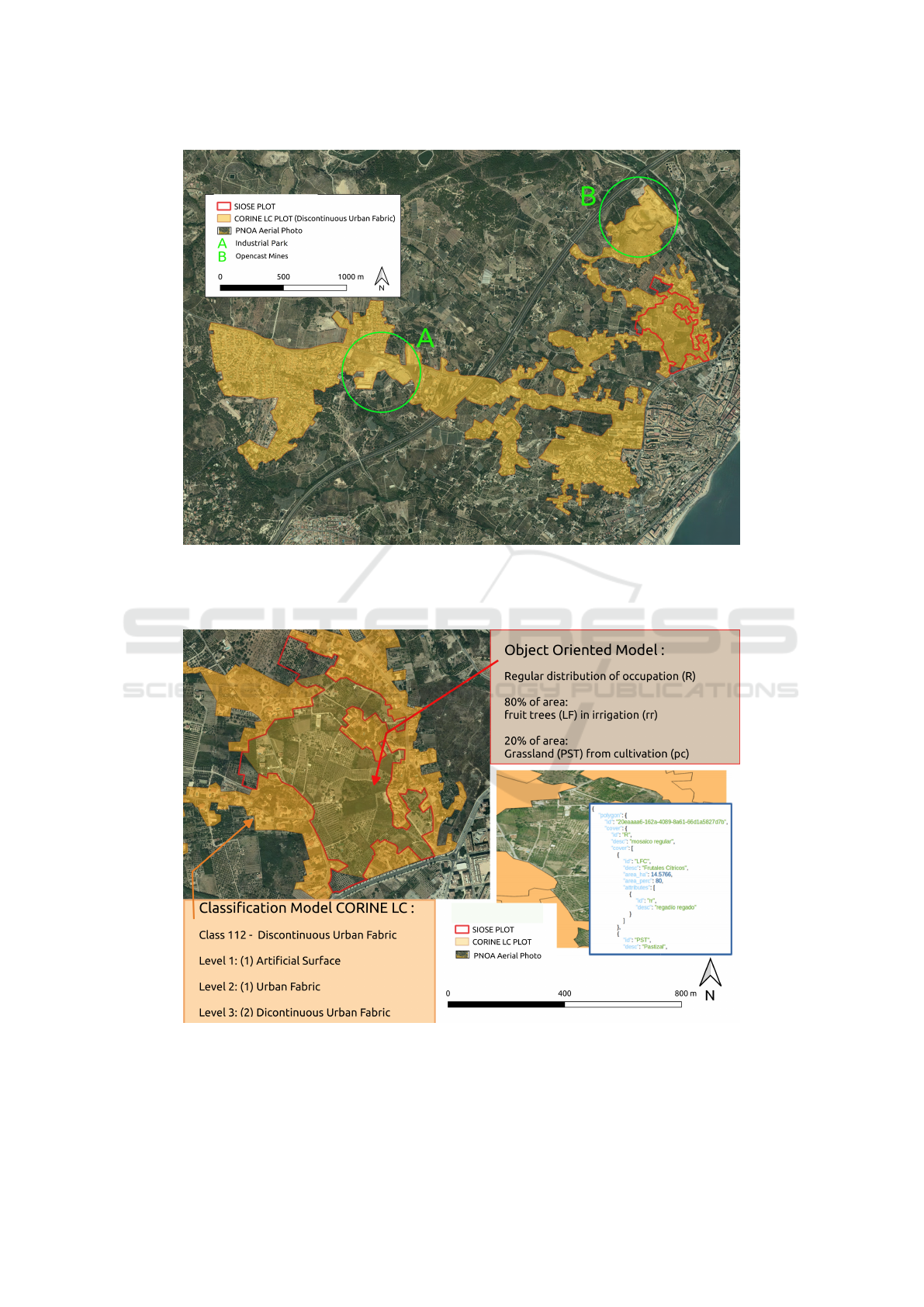
Figure 1: Geometric comparison between a CORINE LC plot (orange limit) and a SIOSE plot (red limit) shows a clear
difference in size and scale (1:100.000 and 1:25.000). Furthermore, the classification of the CORINE plot (Discontinuous
Urban Fabric) hides other realities such as those found in the SIOSE plot (different types of agriculture) or the cases indicated
by green circles: A (Industrial Park) or B (Opencast Mines).
Figure 2: The SIOSE Object-Oriented Model offers more wealth of information than the CORINE LC Classification Model.
SIOSE provides a higher level of detail as to the types of crops and the area quantifiers. In this example, the plot is composed
of 2 covers, 80% of irrigated fruit trees and 20% of cultivated pastures, both regularly distributed).
GISTAM 2020 - 6th International Conference on Geographical Information Systems Theory, Applications and Management
296

data model has also certain drawbacks, and it is of-
ten difficult to understand for non-expert users due to
differences in operation concerning traditional hierar-
chical classifications which may arguably be regarded
as more straightforward. Hierarchical data models,
such as CORINE LC, facilitate the interpretation of
information by reducing thematic resolution so that
directly observable data mostly fit the model require-
ments. On the other hand, the object-oriented model
must be adapted to relational database management
systems with spatial capabilities, and database ad-
ministrators have to deal with this incompatibility at
the conceptual level. SIOSE is a case of the object-
relational impedance mismatch that has been clearly
identified in the literature as a problem of data struc-
ture due to paradigm differences (Ireland et al., 2009).
Another drawback derived from the complexity of the
system is the analysis of the evolution of Land Occu-
pancy and the detection of changes, which must be
carried out not only in geometry but also in seman-
tics (Valcarcel and Casta
˜
no Fern
´
andez, 2013). These
types of problems have already been faced in differ-
ent studies, where the authors point to the usefulness
of the data collected by SIOSE, but also to the dif-
ficulty in handling those data. As for example, some
effort was necessary to use SIOSE LULC data in stud-
ies related to areas such as climate change (Ropero
et al., 2019; Olaya-Abril et al., 2017), flood risk and
mapping of flood areas (Morte et al., 2019), farm-
land abandonment (Pe
˜
na-Angulo et al., 2019), Wild-
land–Urban Interface (Badia et al., 2014) or purely
cartographic studies (Garc
´
ıa-
´
Alvarez, 2018).
Nevertheless, one of the most outstanding aspects
of SIOSE goes beyond the object-oriented data model
and instead resides in the fact that it has led to the
development of a coordinated and participatory pro-
duction system that integrates data from all interested
public administrations. This results in an economy
of effort and an increase in the quality of the out-
comes which has earned it the 2013 UN Public Ser-
vice Award.
In this general context, the SIOSE-INNOVA
project (http://siose-innova.es/) aims to address both
issues, the technical problems related to the SIOSE
object-oriented data model and the usability draw-
backs derived from it. The main objectives of this
work are as follows:
1. To define the SIOSE usability gap by analysing
the ecosystem where these data are used (actors,
contexts and use cases).
2. To evaluate different solutions to overcome the us-
ability gap.
3. To propose a “soft” solution to increase the attrac-
tiveness of the SIOSE database, which comple-
ments other measures based on alternative tech-
nologies or mediating platforms.
3 THE SIOSE USABILITY GAP
In this work, usability is considered as a measure of
quality that evaluates how easily the SIOSE database
is used. The word usability also refers to methods to
improve usability during the design process. Among
the factors that determine the usability, we can men-
tion accessibility, readability, navigability, ease of
learning, speed of use, user efficiency and error rates
(Ben Ramadan et al., 2017). According to this defi-
nition, there may be different actors and use cases in
which the SIOSE database could be more challeng-
ing to manage, query or update, so finding a gen-
eral solution for these many scenarios would require
a broader perspective from the design phase. Thank-
fully, the SIOSE object-oriented model favours exten-
sibility (Valcarcel et al., 2008).
Usability is also a characteristic of a system that is
intended to be used (1) by a specific type of user, (2)
to complete the task for which the system has been de-
signed, and (3) in the context in which the interaction
occurs (Ben Ramadan et al., 2017). In this sense, it
is essential to perform a detailed description of these
three components of the SIOSE environment of ac-
tors, applications and contexts. In this section, we
have attempted to do so.
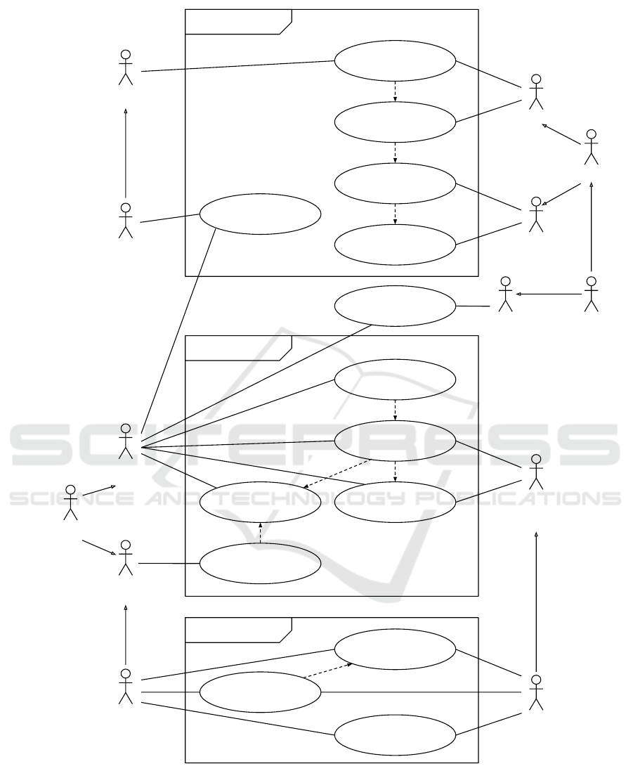
In figure 3, we show a use case diagram in which
we perform an analysis to identify, clarify, and organ-
ise system elements. Of course, this is only a model
that may not be applicable in some cases but, to the
best of our knowledge, this model represents most of
the uses of SIOSE present in the scientific literature
and the uses that we know from our own experience.
The SIOSE project must take into account three dif-
ferent phases that are needed for leveraging the use
of the LULC data. These phases are (1) the produc-
tion phase, (2) the data integration phase and (3) the
usage phase. In each of these phases, we can see dif-
ferent actors – individuals involved with some parts of
the system according to their roles – that accomplish
one or more tasks for the SIOSE environment. On
the bottom left-hand side of the diagram, there are the
main producers of SIOSE, who carry out their tasks
from an official request (see section 1). On the bottom
right-hand side, we have placed sources of Volunteer
Geographic Information, who are encouraged to con-
tribute in situ data to increase the SIOSE data qual-
ity. In the usage phase, we can distinguish those users
with little or no knowledge about spatial databases —
but who use data derived from SIOSE for their spe-
Improving the Usability of the Land Cover and Use Information System of Spain (SIOSE): A Proposal to Distribute New Thematic Layers
and Predefined Reclassifications
297
Non-GIS
consultant
Usage
Reporting
<<include>>
Analysing
<<include>>
Transformation
<<include>>
Data
processing
Publish
processed data
(CLC, SIU, etc)
Mashups /
Infomediaries
GIS technician
GIS user
GIS analyst
GIS Devops GIS scientist
Provide tools
Data Integration
Publish general
purpose data
(SIOSE)
<<include>>
Integrate data
<<include>>
Define data
models
<<extend>>
Data
compilation/selection
<<extend>>
Define
standards
DB Manager /
SDI Manager
Standards organization
(e.g. OGC, ISO, etc)
Mapping agencies or
GIS departments
VGI
organizations
(e.g. OSM)
Data Production
Remote
Sensings
GPS
VGI
GIS producers
or contractors
Photointerpretation
<<extend>>
Figure 3: Use case diagram showing the actors, applications and contexts where the SIOSE is developed.
cific objectives — from other users with varying ex-
perience in exploding the SIOSE database.
The diagram displays actors who can perform dif-
ferent tasks related to their context, so they are more
or less attached to a particular phase. For example,
a GIS technician may be interested in processing or
transforming some SIOSE data — for mapping or an-
alytical purposes — but they usually will not have any
GISTAM 2020 - 6th International Conference on Geographical Information Systems Theory, Applications and Management
298

interest or resources for developing new tools. An-
other example would be that of the Non-GIS consul-
tant, who may be interested in reporting some infor-
mation. Still, they lack experience in working with
geospatial data — so they would need the collabora-
tion of a GIS analyst. However, once the database
manager publishes the general-purpose SIOSE data
sets or the required specific processed data, there are
no specific actors taking care of providing new tools
or facilitating the access to this information (e.g. in
the form of operating environments with custom re-
classifications and pre-configured equivalence maps).
This is represented as the Provide tools task being out
of the main production contexts.
The usability problems of SIOSE may require the
development of new tools that help less expert users
to convert LULC information to custom classifica-
tions that are more useful in their fields of study.
Another possibility would be to strengthen those as-
pects of training that the different actors require in
each case. However, this would affect a significant
number of users and does not seem necessary in a
context where most official GIS data is distributed
in a way that is most usable for users. To date, few
studies have attempted to solve this problem by us-
ing different approaches including the development
of new interoperable web services (Fern
´
andez Villar-
ino et al., 2012), the use of alternative database tech-
nologies (Navarro-Carri
´
on et al., 2016) or the design
of an ArcGIS extension for performing the reclassifi-
cation of hierarchical LULC information (Fern
´
andez
Noguerol, 2017). Apart from these technical solu-
tions, other possibilities may involve a reinterpreta-
tion of the SIOSE data model to allow more specific
information to be attached to the database. From this
perspective, it would be necessary to (1) identify the
main applications that users make of the SIOSE data,
and (2) propose at least one mechanism for allowing
any user to add new thematic information – or useful
reclassifications – that can be reused by the commu-
nity. In this paper, we address the second question (an
extensibility mechanism) in a generic way, consider-
ing that users may have very different needs.
4 AN EXTENSION TO THE SIOSE
DATABASE MODEL
Given its object-oriented design, the SIOSE data
model and other similar models mentioned in the in-
troduction are well prepared to add new elements to
a LULC description without the previous information
being affected.
The SIOSE data model uses the composite pat-
tern, which is a partitioning design pattern which
treats a group of objects in the same way as a sin-
gle instance of the same type of object (Gamma et al.,
1994). In figure 4 this is shown in the three central
classes (LandCoverComponent,LandcoverComposite
and LandCoverLeaf ) and their relationships. This
model can be easily extended through the Attribute
interface, which represents the land-use part of each
land cover component or unit.
We show our proposal in figure 4 and we can use
the SIOSE polygon described in figure 2 to set an ex-
ample on how to read the class diagram. That figure
is showing LULC information from the SIOSE-2011
database, which is the LandCoverDataSet in this ex-
ample. The red polygon can be seen as an instance of
the LandCoverUnit class, which inherits from a ge-
ometry object. A composite land cover composes this
polygon with an 80% of the surface covered by fruit
trees and a 20% of grassland. The composite pattern
would allow any of these land covers to be further
decomposed (e.g. 90% percent are old orange trees,
but a 10% is planted with young avocados, which are
more productive). As seen in figure 2, in the current
SIOSE data model, land use information (Attributes)
can only describe a full land cover (e.g. irrigation for
fruit trees) but, in our proposal a more precise descrip-
tion could be made, for example, to explain if differ-
ent irrigation systems coexist (Presence), which is the
predominant irrigation system (Percentage) or store
the exact length of the irrigation network (Countable).
In this model, it is not necessary that the geometry
be a polygon, we could also use other types of ge-
ometries (for example, points to represent trees, linear
chains for power lines, among other possibilities).
The main difference from the current data model
is the greater semantic richness of the attributes,
which have been so far less important according to
the production scale. This extension or similar modi-
fication is necessary to import or to combine new data
from other sources. For example, it would be possi-
ble to build some thematic information from Open-
StreetMap or save a custom reclassification and dis-
tribute it without losing the link to SIOSE.
5 CONCLUSIONS AND FUTURE
APPLICATIONS
The SIOSE database is an important resource for per-
forming many different geographical studies. The
database is modelled using an object-oriented ap-
proach, which has many technical advantages but
also a few usability problems. This work has shown
that, despite the aforementioned usability problems of
Improving the Usability of the Land Cover and Use Information System of Spain (SIOSE): A Proposal to Distribute New Thematic Layers
and Predefined Reclassifications
299
<<Class>>
LandCoverDataSet
+ name: Character String
+ validFrom: Date
+ ValidTo: Date
+ beginLifespanVersion: DateTime
+ endLifespanVersion: DateTime
<<Class>>
LandCoverUnit
+ inspireId: Identifier
+ beginLifespanVersion: DateTime [0..1]
+ endLifespanVersion: DateTime [0..1]
GM_Object
<<Class>>
LandCoverComponent
+ beginLifespanVersion: DateTime [0..1]
+ endLifespanVersion: DateTime [0..1]
+ getDescription(): Text
+ getRealArea(): Double
+ getPrevalentLandCover(): Text
+ getPrevalentLandCover(threshold): Text
+ IsValid(): Bool
LandCoverType
1..*
1
1..*
1
<<Class>>
LandCoverComposite
+ Pattern: SpatialPattern
+ elements: LandCoverComponent [0..*]
+ add(): Void
+ remove(): Void
+ getChild(): LandCoverComponent
<<Class>>
LandCoverLeaf
1..*
1
Child
Parent
<<Interface>>
Attribute
+ observationDate: Date
+ key: String
1..*
1..*
1..*
1..*
<<Enumerate>>
SpatialPatern
+ Association
+ Regular
+ Irregular
AttributeType
<<Class>>
Percentage
+ value: Numeric (0 - 100]
<<Class>>
Countable
+ value: Numeric
<<Class>>
Presence
+ value: Bool
AttributeType is a label tree (e.g.
protected space, urban planning, etc.)
To define the coverages every
LCComponent will has:
key = observedLC
or
key = RemoteSensedLC
Figure 4: Class diagram for extending the SIOSE data model.
SIOSE, the object-oriented model (a composite pat-
tern), can be easily extended to enrich the LULC
database further.
We have proposed a simple solution for extending
the model, but other possibilities could be evaluated.
We consider it attractive not to lose sight of this pos-
sibility since the fact of enriching the database would
generate certain positive effects: (1) it would com-
pensate even more the effort to work with SIOSE, and
(2) it would open new possibilities in the distribution
of geographic information (e.g. distribute thematic
reclassifications of interest in some fields). In other
words, it would be possible to produce and distribute
specific data sets for different applications (e.g. fire
risk, planning, tourism, etc.).
ACKNOWLEDGEMENTS
This work was supported by grants from the Spanish
Ministry of Economy and Competitiveness, project
SIOSE-INNOVA (CSO2016-79420-R AEI/FEDER
UE). Sergio Trilles has been funded by the post-
doctoral programme PINV2018-Universitat Jaume I
(POSDOC-B/2018/12) and research stays programme
PINV2019-Universitat Jaume I (E-2019-31)
REFERENCES
Anderson, B. J. R., Hardy, E. E., Roach, J. T., and Witmer,
R. E. (1976). A Land Use and Land Cover Classifica-
tion System for Use with Remote Sensor Data. Tech-
nical report, U.S. Geological Survey, Washington.
Antrop, M. (2006). Sustainable landscapes: contradiction,
GISTAM 2020 - 6th International Conference on Geographical Information Systems Theory, Applications and Management
300

fiction or utopia? Landscape and Urban Planning,
75(June 2005):187–197.
Arnold, S., Kosztra, B., Banko, G., Smith, G., Hazeu, G.,
and Bock, M. (2013). The EAGLE concept – A vi-
sion of a future European Land Monitoring Frame-
work. In EARSeL Symposium proceedings 2013, To-
wards Horizon 2020, pages 551–568.
Badia, A., P
`
elachs, A., Vera, A., Tulla, A. F., and Soriano,
J. M. (2014). Land use and land cover change and the
effects on vulnerability to forest fire of counties in the
mountains of Catalonia : from managing the land to
managing a threat. Pirineos. Revista de Ecolog
´
ıa de
Monta
˜
na, 169:1–13.
Ben Ramadan, A. A., Jackson-Thompson, J., and Boren,
S. A. (2017). Geographic Information Systems: Us-
ability, Perception, and Preferences of Public Health
Professionals. Online Journal of Public Health Infor-
matics, 9(2).
B
¨
uttner, G., Feranec, J., and Jaffrain, G. (2002). Corine
land cover update 2000. Technical report, European
Environment Agency, Copenhagen.
Del Bosque Gonz
´
alez, I., Arozarena Villar, A., Villa
Alc
´
azar, G., and Valc
´
arcel Sanz, N. (2005). Creaci
´
on
de un Sistema de Informaci
´
on Geogr
´
afico de Ocu-
paci
´
on del Suelo en Espa
˜
na. PROYECTO SIOSE. In
XI Congreso Nacional de Teledetecci
´
on, pages 255–
262, Puerto de la Cruz, Tenerife. Universidad de La
Laguna.
Fern
´
andez Noguerol, S. (2017). Desarrollo de herramien-
tas para el tratamiento de la informaci
´
on y el an
´
alisis
con SIG de los usos del suelo utilizando el SIOSE.
Una aproximaci
´
on al caso de Asturias. GeoFocus Re-
vista Internacional de Ciencia y Tecnolog
´
ıa de la In-
formaci
´
on Geogr
´
afica, 20(20):233–251.
Fern
´
andez Villarino, X., Delgado Hern
´
andez, J., Valc
´
arcel
Sanz, N., Caballero, M. E., Benito Saz, M. A., and
Porcuna Fern
´
andez-Monasterio, A. (2012). Geoser-
vicios web SIOSE: un sistema de informaci
´
on como
servicio p
´
ublico. In VI Jornadas de SIG Libre, page 8,
Girona. Servei de Sistemes d’Informaci
´
o Geogr
´
afica i
Teledetecci
´
o (SIGTE). Universitat de Girona.
Foster, D., Swanson, F., Aber, J., Burke, I., Brokaw, N.,
Tilman, D., and Knapp, A. (2003). The Importance
of Land-Use Legacies to Ecology and Conservation.
BioScience, 53(1).
Gamma, E., Helm, R., Johnson, R., and Vlissides, J. M.
(1994). Design Patterns: Elements of Reusable
Object-Oriented Software. Addison-Wesley Profes-
sional, Boston, 1 edition.
Garc
´
ıa-
´
Alvarez, D. (2018). The Influence of Scale in
LULC Modeling. A Comparison Between Two Dif-
ferent LULC Maps (SIOSE and CORINE). In Ca-
macho Olmedo, M., Paegelow, M., Mas, J., and Es-
cobar, F., editors, Geomatic Approaches for Modeling
Land Change Scenarios. Lecture Notes in Geoinfor-
mation and Cartography, chapter 10, pages 187–213.
Springer, Cham.
Ireland, C., Bowers, D., Newton, M., and Waugh,
K. (2009). A classification of object-relational
impedance mismatch. Proceedings - 2009 1st Interna-
tional Conference on Advances in Databases, Knowl-
edge, and Data Applications, DBKDA 2009, pages
36–43.
Morte, A. R., Carri
´
on, J. T. N., and Botella, E. G. (2019).
Objective assessment of land use in hydrographical
studies. WIT Transactions on Ecology and the En-
vironment, 234(2019):41–51.
Navarro-Carri
´
on, J. T., Zaragoz
´
ı, B., Ram
´
on-Morte, A., and
Valc
´
arcel-Sanz, N. (2016). Should EU land use and
land cover data be managed with a NOSQL document
store? International Journal of Design & Nature and
Ecodynamics, 11(3):438–446.
Olaya-Abril, A., Parras-Alc
´
antara, L., Lozano-Garc
´
ıa, B.,
and Obreg
´
on-Romero, R. (2017). Soil organic carbon
distribution in Mediterranean areas under a climate
change scenario via multiple linear regression analy-
sis. Science of the Total Environment, 592:134–143.
Omrani, H., Abdallah, F., Charif, O., and Longford, N. T.
(2015). Multi-label class assignment in land-use mod-
elling. International Journal of Geographical Infor-
mation Science, 29(April):1023–1041.
Pe
˜
na-Angulo, D., Khorchani, M., Errea, P., Lasanta, T.,
Mart
´
ınez-Arn
´
aiz, M., and Nadal-Romero, E. (2019).
Factors explaining the diversity of land cover in
abandoned fields in a Mediterranean mountain area.
Catena, 181(May):104064.
Polasky, S., Nelson, E., Pennington, D., and Johnson, K. A.
(2011). The Impact of Land-Use Change on Ecosys-
tem Services , Biodiversity and Returns to Landown-
ers : A Case Study in the State of Minnesota. Envi-
ronmental and Resource Economics, 48:219–242.
Ropero, R. F., Rum
´
ı, R., and Aguilera, P. A. (2019).
Bayesian networks for evaluating climate change in-
fluence in olive crops in Andalusia, Spain. Natural
Resource Modeling, 32(1):1–18.
Valcarcel, N. and Casta
˜
no Fern
´
andez, S., editors (2013).
Cartograf
´
ıa de Ocupaci
´
on del Suelo en Espa
˜
na.
Proyecto SIOSE. Number May 2014. Centro Nacional
de Informaci
´
on Geogr
´
afica (CNIG), Madrid.
Valcarcel, N., Villa, G., Arozarena, A., Garcia-Asensio,
L., Caballlero, M., Porcuna, A., Domenech, E., and
Peces, J. (2008). SIOSE , a successful test bench to-
wards harmonization and integration of land cover/use
information as environmental reference data. In Re-
mote Sensing and Spatial Information Sciences, vol-
ume XXXVII, pages 1159–1164, Beijing.
Villa, G., Valcarcel, N., Caballero, M. E., Porcuna, A.,
Domenech, E., and Peces, J. J. (2008). Land cover
classifications: an obsolete paradigm. In ISPRS
Archives – Volume XXXVII Part B4, pages 619–614,
Beijing.
Improving the Usability of the Land Cover and Use Information System of Spain (SIOSE): A Proposal to Distribute New Thematic Layers
and Predefined Reclassifications
301
