
Alas Landscape Modeling by Remote Sensing Image Analysis and
Geographic Ontology: Study Case of Central Yakutia (Russia)
Sébastien Gadal
1,2 a
, Moisei Zakharov
1,2 b
, Jūratė Kamičaitytė
3c
and Yuri Danilov
2d
1
Aix-Marseille Univ., CNRS, ESPACE UMR 7300, Univ., Nice Sophia Antipolis,
Avignon Univ., 13545 Aix-en-Provence, France
2
North-Eastern Federal University, 670000 Yakutsk, Republic of Sakha, Russian Federation
3
Kaunas University of Technology, Kaunas, Lithuania
Keywords: Geographic Ontology, Image Analysis, Knowledge Database, Image Processing, Alas Landscape, Remote
Sensing.
Abstract: Approaches of geographic ontologies can help to overcome the problems of ambiguity and uncertainty of
remote sensing data analysis for modeling the landscapes as a multidimensional geographic object of research.
Image analysis based on the geographic ontologies allows to recognize the elementary characteristics of the
alas landscapes and their complexity. The methodology developed includes three levels of geographic object
recognition: (1) the landscape land cover classification using Support Vector Machine (SVM) and Spectral
Angle Mapper (SAM) classifiers; (2) the object-based image analysis (OBIA) used for the identification of
alas landscape objects according to their morphologic structures using the Decision Tree Learning algorithm;
(3) alas landscape’s identification and categorization integrating vegetation objects, territorial organizations,
and human cognitive knowledge reflected on the geo-linguistic object-oriented database made in Central Ya-
kutia. The result gives an ontology-based alas landscape model as a system of geographic objects (forests,
grasslands, arable lands, termokarst lakes, rural areas, farms, repartition of built-up areas, etc.) developed
under conditions of permafrost and with a high sensitivity to the climate change and its local variabilities. The
proposed approach provides a multidimensional reliable recognition of alas landscape objects by remote sens-
ing images analysis integrating human semantic knowledge model of Central Yakutia in the subarctic Siberia.
This model requires to conduct a multitemporal dynamic analysis for the sustainability assessment and land
management.
1 INTRODUCTION
The problem of knowledge integration in remote
sensing for the studies of landscape characteristics is
one of the key gaps; especially for the modeling of the
territorial sustainability assessment and ongoing fu-
ture landscape changes (Konys, 2018). The expert ge-
ographic knowledge building based on geographic
ontologies is the most suitable approach. It allows the
integration of expert-human knowledge for the re-
mote sensing image analysis and modeling of the
complexity of the alas landscape system. The ap-
proach based on geographic ontology can be consid-
ered as a specific domain of knowledge in the field of
a
https://orcid.org/0000-0002-6472-9955
b
https://orcid.org/0000-0002-8916-2166
c
https://orcid.org/0000-0002-8821-5764
d
https://orcid.org/0000-0003-4806-4938
the artificial intelligence. Geographical ontologies
used for the alas landscape modeling includes: (a) bi-
ophysical geographic components of landscape (e.g.,
vegetation, moisture, landform (relief), climate con-
ditions, soil (Pashkevich, 2017)); (b) morphologic
forms and geometric objects characteristics (e.g.,
shape, size, textures, topology, geolocation, depres-
sion, inclination, slope), and (c) anthropogenic ob-
jects related to the land field reality measured (cap-
tured) by remote sensing, the human geographic ob-
ject’s identification (semantic meaning) and percep-
tions. The human geographic object’s identification
(semantic meaning) was formalized in Russian and
112
Gadal, S., Zakharov, M., Kami
ˇ
caityt
˙
e, J. and Danilov, Y.
Alas Landscape Modeling by Remote Sensing Image Analysis and Geographic Ontology: Study Case of Central Yakutia (Russia).
DOI: 10.5220/0009569101120118
In Proceedings of the 6th International Conference on Geographical Information Systems Theory, Applications and Management (GISTAM 2020), pages 112-118
ISBN: 978-989-758-425-1
Copyright
c
2020 by SCITEPRESS – Science and Technology Publications, Lda. All rights reserved
Yakutsk languages in a geolinguistic database inte-
grating toponyms, territorial knowledge of local pop-
ulation, census, land uses, maps, etc. (Zamorshikova
et al, 2018). This geo-linguistic database including
the bunch of heterogeneous knowledge poses the
problem of standardization (harmonization). The ap-
plication in the alas landscape combining the
knowledge model, remote sensing and geographic on-
tologies is based on the theoretical model of ontology
(Sinha and Mark, 2010) and on the methodology de-
veloped in remote sensing applied to the subarctic ur-
ban environment in Yakutsk (Gadal and
Ouerghemmi, 2019).
2 ISSUES OF CLIMATE
CHANGES OF THE ALAS
LANDSCAPE
The interest to study the alas landscape is related to
the impacts of climate change and modeling the land-
scape processes. The alas landscapes are localized in
Taiga boreal forest and permafrost territories of the
subarctic region of Siberia, Alaska and Canada. They
are formed as a result of thawing of the permafrost
layer in the exposed parts of the taiga. It makes the
alas one of the key indicators of the permafrost deg-
radation and vulnerability of landscapes in the sub-
arctic region (Fedorov, 2019) and has a major contri-
bution on carbon (CH
4
and CO₂) emission. They have
impact on the forms of steppe azonal soils which have
a high bio-productivity for the agriculture. Agricul-
ture in the subarctic regions is the main framework of
the traditional local lifestyles of Yakutsk and Ekenkii.
According to it, the cultural, social and territorial sig-
nificance of the alas is defined (Desyatkin et al,
2018).
Therefore, the modeling of the alas landscape
needs to integrate both the human semantic factors
and the geo-physical reality, associating quantitative
and semantic parameters defining ontologies of the
alas geographic space. The approach for recognizing
the geographic ontologies merges manually collected
data from the geographic landscape (field observa-
tions, population knowledge formalized in geo-lin-
guistic database), maps and remote sensing data:
Landsat series, 5 TM, 7 ETM+, 8 OLI and Sentinel 2.
Geographic object ontologies are extracted from the
satellite images by semi-automatic or automatic ap-
proach of image analysis (Clouard et al, 2013) using
machine learning algorithms Spectral Angle Mapper
(SAM) on the Landsat series images according to the
better performance (overall accuracy). Two ap-
proaches were applied for the Sentinel 2 images: (a)
the Support Vector Machine (SVM) for the recogni-
tion of the geographic objects by pixel-based classifi-
cation (Li et al 2009, Ouerghemmi et al, 2017) show-
ing the land cover landscape of the alas and the envi-
ronment around, and (b) the OBIA based on the De-
cision Tree algorithm (DT) (Vopham et al, 2018) and
the morphological image filtering based on the con-
trast and texture information through large-scale
smoothing for image segmentation (Maragos, 1989,
Sofou et al, 2005) that helped to identify automati-
cally the current different geographic objects defining
the actual alas. Results are integrated and merged in
GIS. It must be noted that the application of the DT
algorithm on the Landsat TM, ETM+, OLI is not rel-
evant because of the too low GSD of 30m.
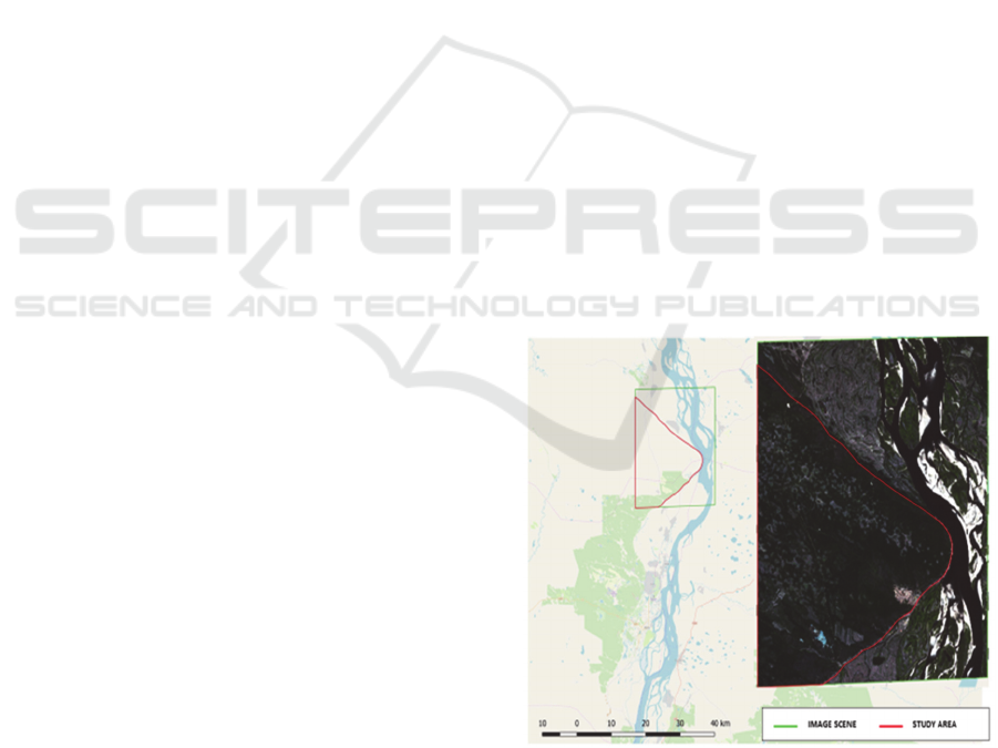
2.1 Study Area
The Central Yakutia lowland is characterized by the
widespread distribution of Alas. Throughout the ter-
ritory there are about 16000 alas between Vilyuy,
Lena and Aldan Rivers. The study area is located at
40 km distance to the North from the city of Yakutsk
covering the surface of 30000 hectares (Fig. 1). The
study area is a boreal forest represented by pine and
larch. The soil basis is permafrost with a layered and
lenticular texture, where thermokarst cryogenic pro-
cesses are developed, which cause the formation of
numerous alas.
Figure 1: The study area [© Open Street Map]; the extent
of the Sentinel 2A RGB scene at 26th of July 2019.
Alas Landscape Modeling by Remote Sensing Image Analysis and Geographic Ontology: Study Case of Central Yakutia (Russia)
113
3 IMAGE ANALYSIS OF ALAS
LANDSCAPE STRUCTURE
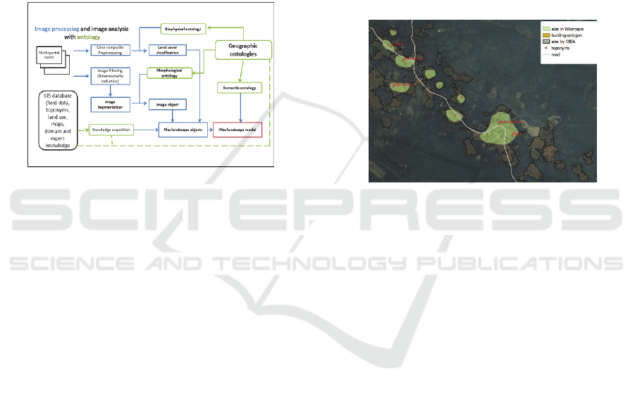
3.1 Methodology
The geographic objects as ontological elements are
the basis of the structure and organization of a land-
scape (Gadal, 2012). In remote sensing they are iden-
tified by image processing and image analysis (here
by machine learning, landscape object classifications,
and OBIA image segmentation) with the knowledge
GIS database and the implementation of ontological
rules (Fig. 2).
Figure 2: Implementation of image analysis with geo-
graphic ontologies for alas landscape recognition.
The typical alas landscapes consist of the follow-
ing elementary geographic objects: lake, grassland,
woodland, built-up and arable lands for agriculture.
First, they are identified and analyzed according to
the land cover classes produced from the biophysical
parameters measured spectrally by Landsat series and
Sentinel 2 data.
The second level of the geographical objects
recognition by object-oriented classification algo-
rithms of DT is resulted from knowledge acquisition
(Clouard et al, 2010) structured in the geo-linguistic
database and integrated in GIS, and the OBIA to ex-
tract the morphology structures of the alas landscape.
The categorization of the alas landscapes objects gen-
erated is followed-on by the fusion of land cover
maps and alas landscape object classification.
The data analyzed include the expert and the do-
main knowledge (landscape theories, concepts, indic-
ative and cognitive analysis products) (Gadal and
Ouerghemmi, 2019). The ontological approach ena-
bles us to obtain numerous representations of all as-
pects of the alas landscape spatial organization
through the accurate acquired knowledge structured
in the GIS database. It is used both for training, learn-
ing and the validation of results, the spatial analysis
and modeling in GIS.
The integrity and the logic coherence of all pro-
cesses taking place in geographic space is ensured by
the integration of semantic geographic object ontolo-
gies modelled by the geostatistical analysis of geo-
linguistics database (toponyms, territorial knowledge
of local population, census, land uses, maps, etc.)
with the categorization of alas landscape based on
GIS knowledge database.
The obtained alas landscape model (Fig. 3) is a
multidimensional model including knowledge and
geo-linguistic GIS database adapted for machine
learning training and simulation of geospatial pro-
cesses: rural exodus, permafrost degradation, etc.
having impact on the landscape’s changes and their
consequences (sustainability, re-greening).
Figure 3: Alas landscape model map with knowledge and
geo-linguistic GIS database. Terra-Metrics, DigitalGlobe
2012.
3.2 Image Processing
3.2.1 Recognition of Objects of Landscape
Land Cover Change
The recognition of the landscape objects and the
change dynamics modeling between 2007 and 2019
is based on the use of the Landsat 5 TM (date:
15.07.2007), Landsat 8 OLI (bands 2 to 7: VIR-NIR-
SWIR) pansharpened at 15m (date: 26.07.2013) and
Sentinel 2A (bands 2 to 5: VIR- NIR at 10m) (date:
24.07.2019) acquired in July.
Landscape land covers produced and mapped by
supervised classification are used as training data of
the GIS database. Landscape objects are recognized
by the spectral signatures related to the geographic
objects of the GIS database. Several classifier algo-
rithms were tested: Minimum Distance (MD), Maxi-
mum Likehood (ML), the K-Nearest Neighbors (K-
NN), Spectral Angle Mapper (SAM) and Support
Vector Machine (SVM).
The results show that the optimal machine learn-
ing classifiers are obtained with SAM for the Landsat
5 TM and the Landsat 8 OLI data confirming the re-
sults presented by Pertopoulos et al. (2010) (Tab. 1).
GISTAM 2020 - 6th International Conference on Geographical Information Systems Theory, Applications and Management
114
The most reliable results for the landscape land cover
were proceeded with the SVM based on Kernel
method for the Sentinel 2A images (Pal and Mather,
2005) (Fig. 4, 5).
Table 1: Results obtained from applied classifiers.
Classifi-
cation
algorithm
O.A. / Kappa
2007 2013 2019
MD 72%/0,45 67%/0,44 45%/0.37
ML 43%/0,31 56%/0.39 54/0.36
K-NN non non 34%/0.21
SAM 77%/ 0.57 81%/ 0.64 67%/0,59
SVM non non 83%/0,65
The accuracy of landscape land cover classifica-
tions is provided with 50 randomly generated poly-
gons (3x3 pixels size). The random set of vector data
(by 3x3 pixels) constitutes the validation data set.
They are used for the accuracy assessment of the clas-
sification by confusion matrix and Kappa coefficient.
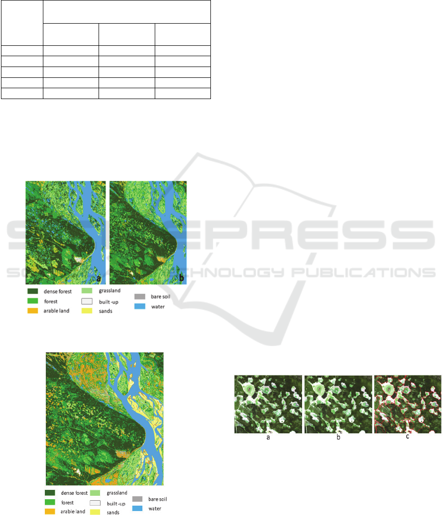
Figure 4: Land cover classification by SAM for Landsat 5
TM in 2007 (a) and Landsat 8 OLI in 2013 (b).
Figure 5: Land cover classification result for Sentinel 2A
with SVM classifier.
3.2.2 Alas Recognition by Object-based
Image Analysis
The recognition of alas is based on two criteria that
ontologically characterize geographical objects: mor-
phology and their own geometries. They lend them-
selves to OBIA procedures. The satellite images used
are from the VIR and NIR bands of Sentinel 2A, in
particular because of their spatial resolution of 10m
that enables to recognize the geometric shapes and the
structures of the alas. The alas as a unique geographic
object is characterized ontologically by its geometry
and by the geographic objects that compose it such as
lakes, meadows, swamps, the presence of farms and
forests surrounding it. These geographic objects are
identified by classification (part 3.2.1.) with the land-
scape cover maps (fig. 4, fig. 5).
The detection, identification and extraction of alas
from their morphological characteristics lends itself
well to the OBIA object-oriented machine learning
classification algorithms. The OBIA alas recognition
consists of four phases: (a) The dimensionality reduc-
tion by the Principal Component Analysis (PCA) al-
gorithm, and linear combination of original bands that
contains 91-95% of spectral information in first three
components (Fig 6a). (b) Smoothing filtering that is
applied for the suppression of noise and homogenize
statistically the alas regions. This filtering method as-
sociates with each pixel of the image the closest local
mode in the density distribution of the combined re-
gion (Comaniciu and Meer, 1999, 2002). (c) The im-
age segmentation by Large Scale MeanShift non-par-
ametric and iterative clustering method (Michel et al,
2015). The segmentation produces a labeled image
with tile-wise processing where neighbor pixels
whose range distance is below range radius and op-
tionally spatial distance below spatial radius are
merged into the same raster value (Fig. 6c). The aver-
age spatial neighborhood radius is 25 meters.
Figure 6: Object recognition from Sentinel 2A (a) RGB of
PCA components; (b) MeanShiftSmoophing filtering; (3)
Image segmentation of alas.
The most complete extraction of alas is obtained
with the following parameters: the spatial radius – 50;
the range radius – 25; the Minimum segment size –
10. The main geometrical parameters distinguishing
alas and thermokarstic basins concern their shapes:
Alas Landscape Modeling by Remote Sensing Image Analysis and Geographic Ontology: Study Case of Central Yakutia (Russia)
115
alas has a shape close to the circle, does not have dis-
tinct angles, and is not characterized by elongation
contrary to thermokarstic shapes. (d) The fourth
phase consists in separating the alas from another an-
thropogenic objects: agricultural parcels. The identi-
fication methodology uses a decision tree algorithm.
This machine learning algorithm required a dataset
that selected 30 polygons generated using the GIS da-
tabase, more specifically the alas toponyms, topo-
graphic maps and Open Street Map data. The classi-
fication structure defined by the decision tree is esti-
mated from the training data using a statistical proce-
dure of overall mean and standard deviation for 3
PCA components. The decision rules developed are
used to associate each segment of the image with one
of the geographic object classes. The O.A. with Sen-
tinel 2A data is =88.4%; a Kappa coefficient is 0,83
for the Decision Tree classifier.
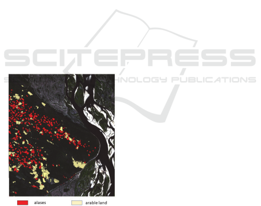
The result is two broad types of geographic ob-
jects in which elementary ontological and geographic
structures are reflected: alas and arable lands of agri-
culture (Fig. 7). The information was obtained
through the interpretation of remote sensing data by
artificial intelligence with the integration of expert
knowledge for learning and validation of the obtained
results. This GIS-structured information set provides
the basis for a comprehensive spatial analysis using
semantic ontology to model the landscape dynamics
of the boreal forests of alas and permafrost.
Figure 7: Alas identification by OBIA with Sentinel 2A im-
age.
4 ALAS LANDSCAPE
MODELING
In this part, some applications of the image analysis
data obtained in the modeling of the alas landscapes
are presented. The ecological status of the alas land-
scapes plays an important socio-economic role, as
well as in the dynamic processes of the permafrost.
The results of spatial remote sensing image analysis
using GIS-integrated geographic ontologies are de-
signed to serve as a basis and environment for this
research. Thus, the modeling of geo-linguistic land-
scape features has been developed in GIS with the
creation of an extensive geographically referenced
database. It aims to understand better the land use and
to measure the complexity of landscape structure.
The first method consists of performing modeling
analysis land covering changes within alas. The four
categories were identified according to the structure
of alas vegetation: (a) Termokarst lake, when the alas
basin is completely filled with water; (b) Complex
alas, when vegetation changes from steppe to coastal-
aquatic; (c) herbaceous alas, when vegetation is rela-
tively uniform throughout all alas territories; (d) pas-
ture alas, with active arable or hay areas. The appli-
cation of knowledge about the vegetation species of
alas allows interpreting land cover classes and to as-
sess the stability and transformation of the alas land-
scape. In total, the alas include 5 typical land cover
classes. A highly moistened alas section belongs to
the grass, less – often to the forest due to close vege-
tative indicators (chlorophyll intensity). In some
cases, the presence of forests inside the alas indicates
the presence of a hill, that are indicators of the pres-
ence of permafrost heaving tubercles – pingo. The ar-
able land is the middle alas section, the most bio-pro-
ductive section often used as a forage base for cattle-
breeding and horse-breeding. The peripheral portion
of alas with a lack of moisture forms the azonal steppe
vegetation and stands out as a class of bare soils. Ta-
ble 2 shows examples of alas with the percentage
structure of the land cover and the corresponding cat-
egory.
This categorization allows us to consider the stage
of spatio-temporal development of alas, water con-
tent, and to obtain data on anthropization and eco-
nomic activity. This model also has a perspective for
the development of simulation strategies for the trans-
formation of plains landscapes of permafrost.
GISTAM 2020 - 6th International Conference on Geographical Information Systems Theory, Applications and Management
116

Table 2: Examples of alas landscape categorization by land
cover structure.
Name Year
Land cover classes (%)
Alas
category
forest
Ara
ble
land
grass
bare
soil
water
Ton-Bas
(Тон-
Бас)
2007 17 2 34 0 48
termokarst
lake
2013 18 6 23 17 35
complex
alas
2019 5 10 63 20 2
complex
alas
Mokh-
sogo-
lokh
(Мохсо
голлох)
2007 53 0 9 0 37
termokarst
lake
2013 1 0 99 0 0
herba-
ceous alas
2019 5 38 57 0 0
pasture
alas
Sier-Bie
(Сиэр-
Бие)
2007 1 0 81 0 18
herba-
ceous alas
2013 1 45 53 0 1
pasture
alas
2019 1 47 42 0 11
pasture
alas
The second method is based on landscape seman-
tic analysis using the geo-linguistic database. The alas
landscapes are the main source of livelihood for the
local population, which implies the presence of a cul-
tural layer of information of the geographical ontol-
ogy, within the framework of local knowledge about
the geographical space. Semantics provides a transi-
tion from the object level of the geographical ontol-
ogy, where the main concept is geographical objects
represented in our case as land-use classes - the alas -
and the results of their modeling according to the ex-
pert knowledge (alas categories, vegetation species),
to the spatial level of the geographical ontology. This
territorial knowledge generates geographic models
recognition and identification of which constitute a
new challenge for artificial intelligence in space and
airborne remote sensing.
The spatial organization of the local economy in-
volves the location of villages and farms in the alas.
Due to their rarity, they cannot be recognized by im-
age processing from medium spatial resolution im-
ages such as Sentinel 2A/B, Landsat 5/6/7/8, and are
included in the class of arable (agricultural) land.
When their presence was known, we reclassified the
pixel sets of the arable (agricultural) land value into
the buildings class by comparing them with the se-
mantic layer of settlements and sayylyks (summer
houses).
An initial geo-linguistic analysis also allows us to
identify the alas used in agriculture, which may have
been abandoned recently. Compared to satellite im-
ages analysis, the absence of a semantic layer can in-
dicate the age and time of alas formation. The GIS
semantic database also allows the dissemination of re-
mote sensing knowledge and facilitates the interpre-
tation of landscape ontology. It provides a semantic
description of the results of analysis and processing
of remote sensing images.
5 CONCLUSIONS
Geographic ontologies image analysis in artificial in-
telligence is a necessary part of knowledge that com-
bines multi-level and heterogeneous concepts of an
object and a geographic space, and as well geo-lin-
guistics in order to implement a systematic approach
to the modeling of alas landscapes. Although, the de-
veloped model confronts the technical issues, such as
the standardization and harmonization of heterogene-
ous information flows, it also establishes the rules for
solving decision-making problems, for environmen-
tal and agricultural monitoring under the conditions
of continuously expanding permafrost in subarctic
climate.
This research significantly contributes to the de-
velopment of application of knowledge model to im-
prove remote sensing image processing analysis and
landscape modeling for the territorial and geographic
studies. The novelty of the research comprises the in-
tegration of the geo-linguistic database reflecting the
semantic meaning of people's knowledge as part of
the geographic ontology of alas landscapes. It allows
to analyze the value, the age and the evolution of alas
increasing the accuracy of recognition of alas objects.
One of the main challenges is to hybridize geo-
graphical knowledge with artificial intelligence used
to analyze the landscapes and the cross processes of
anthropization and geophysical evolution of perma-
frost by spatial and airborne remote sensing.
ACKNOWLEDGEMENTS
This research was supported by the French National
Research Agency (ANR) through the PUR project
(ANR-14-CE22- 0015), the Russian Science Founda-
tion № 15-18-20043 “Landscape Ontology: Seman-
tics, Semiotics and Geographical Modeling”, and the
Vernadski Grant of the French Embassy in the Rus-
sian Federation.
Alas Landscape Modeling by Remote Sensing Image Analysis and Geographic Ontology: Study Case of Central Yakutia (Russia)
117

REFERENCES
Clouard, R., Renouf, A., Revenu, M., 2010. An Ontology-
Based Model for Representing Image Processing Ob-
jectives. International Journal of Pattern Recognition
and Artificial Intelligence, World Scientific Publishing,
pp.1181-1208.
Comaniciu, D. and Meer, P. 1999. Mean shift analysis and
applications. International Conference on Computer
Vision, 2, pp. 1197-1203.
Comaniciu, D., and Meer, P. 2002. Mean shift: A robust
approach toward feature space analysis. IEEE Transac-
tions on pattern analysis and machine intelligence,
24(5), pp. 603-619.
Desyatkin, A., Takakai, F. and Nikolaeva, M. 2018. Land-
scape Microzones within Thermokarst Depressions of
Central Yakutia under Present Climatic Conditions. Ge-
osciences 2018, 8. MDPI
Fedorov, A., 2019. Permafrost Landscapes: Classification
and Mapping. Geosciences 2019, 9. MDPI.
Gadal, S., 2012. Geographic Space Ontology, Locus Ob-
ject, and Spatial Data Representation Semantic Theory.
Universal Ontology of Geographic Space: Semantic
Enrichment for Spatial Data, IGI Global, pp.28-52,
9786-1-4666-032-27-1.
Gadal, S., and Ouerghemmi, W., 2019. Knowledge Models
and Image Processing Analysis in Remote Sensing: Ex-
amples of Yakutsk (Russia) and Kaunas (Lithuania). In
Proceedings of the 5th International Conference on Ge-
ographical Information Systems Theory, Applications
and Management, Heraklion, Crete – Greece. pp. 282-
288.
Konys, A., 2018. An Ontology-Based Knowledge Model-
ling for a Sustainability Assessment Domain. In Sus-
tainability Journal 10.
Kordjamshidi, P., Moens, M-F. 2014. Global Machine
Learning for Spatial Ontology Population. Journal of
Web Semantics pp. 1-29
Li, J., Carlson, B.E., and Lacis A.A., 2009. A study on the
temporal and spatial variability of absorbing aerosols
using total ozone mapping spectrometer and ozone
monitoring instrument aerosol index data. J. Geophys.
Res., 114.
Maragos, P. 1989 A representation theory for morphologi-
cal image and signal processing. IEEE Transactions on
Pattern Analysis and Machine Intelligence 11.6 pp.
586−599.
Michel, J., Youssefi, D., & Grizonnet, M. (2015). Stable
mean-shift algorithm and its application to the segmen-
tation of arbitrarily large remote sensing images. IEEE
Transactions on Geoscience and Remote Sensing,
53(2), pp. 952-964.
Ouerghemmi, W., Gadal, S., Mozgeris, G., Jonikavičius,
D., and Weber, C., 2017. Urban objects classification
by spectral library: feasibility and applications. In 2017
Joint Urban Remote Sensing Event (JURSE), Dubai,
pp. 1- 4.
Sinha, G., Mark, D., 2010. Toward A Foundational Ontol-
ogy of the Landscape. MDPI.
Sofou, A., Evangelopoulos, G., Maragos, P. 2005. Soil Im-
age Segmentation and Texture Analysis: A Computer
Vision Approach. IEEE Geoscience and Remote Sens-
ing Letters, Vol. 2, No. 4, pp. 394-398
Pal, M. and Mather, P. 2005. Support vector machines for
classification in remote sensing. In International Jour-
nal of Remote Sensing Vol.5. pp. 1007-1011
Pashkevich, M., 2017. Classification and Environmental
Impact of Mine Dumps. In Assessment, Restoration and
Reclamation of Mining Influenced Soils. pp. 1-32
Petropoulos, G., Vadrevu, K., Xanthopoulos, G., Karantou-
nias, G., Scholze, M. 2010. A Comparison of Spectral
Angle Mapper and Artificial Neural Network Classifi-
ers Combined with Landsat TM Imagery Analysis for
Obtaining Burnt Area Mapping. Sensors. pp. 1967-
1985.
Puebla-Martınez, M., Perea-Ortega, J., Simon-Cuevas, A.,
and Romero, F. 2018. Automatic Expansion of Spatial
Ontologies for Geographic Information Retrieval.
Communications in Computer and Information Sci-
ence. pp. 659-670
VoPham, T., Hart, J., Laden, F. and Chiang, Y. 2018.
Emerging trends in geospatial artificial intelligence (ge-
oAI): potential applications for environmental epidemi-
ology. Environ Health 17, 40
Zamorshchikova, L., Khokholova, I., Ikonnikova, A., Sam-
sonova, M. and Lebedeva, V. 2018. Toponymic Land-
scape of Central Yakutia: Etymological Analysis of Ge-
ographical Names. Journal of Siberian Federal Univer-
sity. Humanities & Social Sciences.
GISTAM 2020 - 6th International Conference on Geographical Information Systems Theory, Applications and Management
118
