
Relation between Proximity to Public Open Spaces
and Socio-economic Level in Three Cities in the Ecuadorian Andes
María Laura Guerrero
1a
, Daniel Orellana
1,2 b
, Jorge Andrade
3
and Gabriela Naranjo
4c
1
LlactaLAB – Ciudades Sustentables, Departamento de Espacio y Población, Universidad de Cuenca, Av. 12 de Abril,
Cuenca, Ecuador
2
Facultad de Ciencias Agropecuarias, Universidad de Cuenca, Av. 12 de Octubre, Cuenca, Ecuador
3
Escuela de Arquitectura, Pontificia Universidad Católica del Ecuador sede Ibarra, Av. Jorge Guzmán, Ibarra, Ecuador
4
Facultad de Arquitectura Diseño y Artes, Pontificia Universidad Católica del Ecuador, Av. 12 de Octubre, Quito, Ecuador
Keywords: Public Open Spaces, Proximity, Environmental Justice.
Abstract: Public Open Spaces (POSs) are necessary urban goods for satisfying personal and collective needs for
physical, social and mental wellbeing. Equitable spatial access to POSs is key for guaranteeing that resources
for wellbeing are democratically available for all members of the community. Environmental justice states
that contemporary cities have a biased distribution of public spaces, against socially and economically more
disadvantaged sectors of society. Under these premises, this paper evaluates whether there is a case of
environmental imbalance in access to public spaces in three Ecuadorian cities: Quito, Cuenca and Ibarra,
based on the socio-economic status of the population. A pedestrian impedance street network model was used
for obtaining time to the nearest Public Open Space from each urban block, and socio-economic conditions
were obtained from national census data per household and divided into quartiles. Statistical analyses included
Mood’s Median Test, Dunn’s post-hoc test and notched boxplots for assessment. Results show that there is a
significant difference in time to public spaces between quartiles, where the quartile with the lowest socio-
economic conditions is also further from public spaces than the others in the three cities. These results should
inform planning policies, strategies, designs and decisions for future leisure land use reserves.
1 INTRODUCTION
Urban open spaces, such as parks, forests, streams,
squares and community gardens, provide critical
ecosystem services and benefit physical activity,
social bonding, psychological and general well-being
of urban residents (Wolch, Byrne, & Newell, 2014).
One important characteristic of sustainable urban
development is a spatial pattern where facilities are
spatially distributed in a way that they benefit as
many different social groups as possible (Talen,
2010). However, studies have reported consistently
that neighbourhoods with higher socioeconomic
levels enjoy greater accessibility to green spaces
(Talen, 2010; Wen, Zhang, Harris, Holt, & Croft,
2013). Attention must be paid to avoid racial,
economic and social inequalities in access to urban
a
https://orcid.org/0000-0001-5164-1455
b
https://orcid.org/0000-0001-8945-2035
c
https://orcid.org/0000-0003-0570-7446
goods in planning processes for creating more
democratic, equitable cities.
The vast majority of studies about proximity to
public spaces has been conducted in developed
countries such as the United States, the United
Kingdom, Australia, Europe, and some large Asian
cities (Wolch et al., 2014). Only recently, researchers
are studying the spatial relationship between
socioeconomic conditions and proximity to urban
public spaces in Latin America, and to date there are
only a few cities in the region with published studies
(Fernández-Álvarez, 2017; Mayorga Henao &
García, 2018; Tiznado-Aitken, Muñoz, & Hurtubia,
2018).
This paper investigates whether there is a bias
regarding access to public spaces due to socio-
economic conditions in three Ecuadorian cities. It
Guerrero, M., Orellana, D., Andrade, J. and Naranjo, G.
Relation between Proximity to Public Open Spaces and Socio-economic Level in Three Cities in the Ecuadorian Andes.
DOI: 10.5220/0009396600810091
In Proceedings of the 6th International Conference on Geographical Information Systems Theory, Applications and Management (GISTAM 2020), pages 81-91
ISBN: 978-989-758-425-1
Copyright
c
2020 by SCITEPRESS – Science and Technology Publications, Lda. All rights reserved
81

studies the spatial distribution of public spaces in
relation to the socio-economic conditions of urban
dwellers, providing evidence for both future public
policies and planning guidelines. It also provides a
transparent and replicable methodology using
available public data from official sources and
Volunteered Geographic Information platforms.
The first section of the paper presents the
theoretical background on public space proximity.
The second section details the methodology, datasets,
data processing and statistical analyses. The third
section presents the results and discussion, and the
last section focuses on conclusions and further
research.
2 BACKGROUND
Environmental justice studies whether the
distribution of urban risks and benefits is biased,
disfavouring racial minorities (environmental racism)
and population with lower socioeconomic status
(environmental classism), based on research on
absolute and relative spatial distribution of amenities,
risks, and population in cities (Bolin et al., 2000;
Fernández-Álvarez, 2017). For environmental
justice, the term Environment is defined as the set of
linked places “where we live, work, learn and play,”
a concept that challenges traditional definitions of
environment and nature by including urban areas,
which allows urban inhabitants to be incorporated
into the environmental debate (Turner et al., 2002).
In most cities, the last two hundred years of urban
development history have been dominated by market
dynamics. These dynamics dictate the pattern of
physical production of space, making product
urbanism, competitive strategies, and private
initiatives the major forces of social and spatial
segregation in cities, leaving public spaces as
residuals from private development (Mayorga Henao
& García, 2018).
The definitions of Public Open Spaces (POSs) are
diverse, subject to constant change and discussion,
and depending on the author, sometimes it has
contradictory characteristics. In a recent review of
POS definitions, Andrade et al. (2019) elaborate on
the wide range of characteristics of POSs in the
international and legal literature. These authors have
proposed a definition applicable to this research:
“Unbuilt urban open space for recreational, civic,
natural or cultural purposes, accessible for the
whole community for free and without restriction;
primarily (although not exclusively) owned by
public subjects, capable of hosting a variety of uses
and accommodating diverse users to enhance
inclusion and social equity, suitable for protecting
ecosystems and the sustainability of human
settlements”
This definition is purposefully multidimensional
and attempts to encompass many aspects, in
accordance with Kohn (2004), who suggests a way to
handle the diverse and somehow contradictory
definitions of POSs. This author proposes the
definition to ensure that it comprises a range of
possible criteria, where a sub-selection of them would
enable a space to be qualified as a POS, and not
having one of the criteria wouldn’t mean that the
space is not a POS.
Public Open Spaces are important in terms of
environmental justice for several reasons. First, they
offer opportunities for physical activity that prevents
the risk for chronic conditions such as obesity and
heart disease (Wolch et al., 2014), and they improve
the psychological health of modern communities
(Mehta, 2014). Second, POSs, such as parks and other
green areas, offer ecological services, including
maintenance of biodiversity, regulation of urban
climate, and mitigation of pollution effects and floods
via water infiltration (Haq, 2015). Lastly, they
provide a relevant social benefit, enriching urban life
with meaning and emotions (Fernández-Álvarez,
2017). This social importance has been described by
Mehta (2014) in four key roles for public spaces: as
an arena for public life, as a meeting place for
different social groups, as a space for displaying
social symbols, and as part of the communications
system between urban activities. All urban dwellers
should have equal rights to access these benefits.
From the many variables that influence the use of
public open spaces, such as size, quality,
attractiveness (amenities within the space), proximity
and accessibility, the latter two have been given more
attention. For instance, Pasaogullari (2004) explored
visibility, physical structure, sidewalks, dispersion,
and proximity, finding that variables like proximity,
dispersed location, travel time and characteristics of
the transport environment affect accessibility to
public spaces directly in Famagusta, Cyprus. Lotfi &
Koohsari (2009) analysed proximity to various urban
services, including POSs, in relation to deprivation
levels of the population, finding, surprisingly, that for
the case of Tehran, neighbourhoods with higher
deprivation have better access to public spaces.
Tiznado-Aitken et al. (2018) focused on analysing
both proximity to public transport stops and urban
walking environment together to understand the
accessibility to POSs in Santiago, Chile, in relation to
the socio-economic situation of the population,
GISTAM 2020 - 6th International Conference on Geographical Information Systems Theory, Applications and Management
82

finding a correlation between low income and poor
access and urban space quality. Bancroft et al. (2015)
in a systematic review found a variation in the
association between access to parks and physical
activity, possibly due to the heterogeneity of exposure
measurements (variables related to parks like
proximity, density, amenities); therefore, they
recommended improvements in study design and
sampling to clarify the relationship between access to
parks and physical activity. The authors mention that
in the current study designs, perceived park
environment characteristics and smaller (vs. larger)
buffer sizes seemed to be more predictive of physical
activity.
It is worth making a distinction between
proximity and accessibility. Proximity refers to the
direct physical distance between two things.
Accessibility, on the other hand, is a far more
complex definition than just a spatial mismatch. It
involves influential factors such as user
characteristics, social and physical barriers, attributes
of the facility, and interaction with other facilities in
the system (Wang et al., 2013). Furthermore,
accessibility to public spaces also has been defined as
a measure of the spatial distribution of facilities
adjusted for the desire and the ability of people to
overcome distance or travel time to access a POS
(Giles-Corti et al., 2005). In this sense, this paper
focuses on proximity, where distance is a component
of a wider concept that determines how reachable
urban services are for different groups. The wider
concept, accessibility, can be tackled in further
research.
Accessibility is closely related to the urban form,
which makes it possible for citizens to participate in
activities, obtain resources, and benefit from services
and information (Lynch, 1960). Moreover,
accessibility is affected by zoning policies and sprawl
patterns in cities, which tend to make distances
increase for working purposes; therefore, they should
decrease for the satisfaction of other needs, like
leisure in POSs. In terms of democratic access,
assessing proximity makes sense where transport
means are available for the entire population, making
walking the most suitable form of transport, since it
can be used without income, race or gender
distinctions (Mayorga Henao & García García, 2018).
There is a trend in the literature to use 400m as a
distance to estimate the potential 'walk-on' or 'walk-
off’ threshold to urban services (Koohsari, Badland,
& Giles-Corti, 2013); other studies indicate that it is
a good starting point, but a person’s willingness to
walk is also influenced by weather conditions, total
travel time, walking distance to the destination,
footpath access to traffic being negotiated, and the
attractiveness of the route (Daniels & Mulley, 2013;
Ker & Ginn, 2003).
In this paper, we investigate the accessibility to
public open spaces in three cities in terms of
proximity to the place of residence of urban dwellers
for three cities in the Ecuadorian Andes (Quito,
Cuenca and Ibarra). Moreover, we evaluate if there is
a relation between the socio-economic level and the
proximity to POSs.
3 METHODOLOGY
We assessed population’s proximity to POSs by
evaluating walking time to the nearest POS from each
city block. Individual dwellers were categorised
according to their socio-economic conditions to
appraise whether there is a bias in accessibility for
different socio-economic levels.
3.1 Study Area
The three cities were chosen due to their different
sizes (metropolitan, intermediate and small cities),
which allows evaluating the existence of patterns
regarding public space distribution and conditions in
the region that are not dependant on city size.
Quito is the capital of the country and also of
Pichincha province, with an urban population of
1,021,474 million and a surface of 266.75Km2. The
surface for public spaces is 24.37Km2 (7.09%).
According to this data, the green urban index is
23.86m2/inhabitant. It is located at 2,850 m.a.s.l. at
the base of the Pichincha volcano (west) and limited
by the geologic fault EC-31 to the east. Both
geographic landmarks highly determine its
morphological development in a longitudinal way,
hence challenging mobility and distribution of
services.
Cuenca is the capital of Azuay province, with
323,000 urban inhabitants; it covers 73Km2. From
this, 2.43Km2 (3.3%) are dedicated to POSs. The
green urban index is 7.52m2/inhabitant. It is located
in an inter-Andean valley at 2,500 m.a.s.l. Hydrology
is very important in Cuenca, with 4 main rivers and
11 secondary water courses, like creeks, crossing the
city. The city shape is strongly influenced by a
terraced geomorphology and several rivers and
streams, which makes connectivity one of the main
challenges for urban development.
Relation between Proximity to Public Open Spaces and Socio-economic Level in Three Cities in the Ecuadorian Andes
83
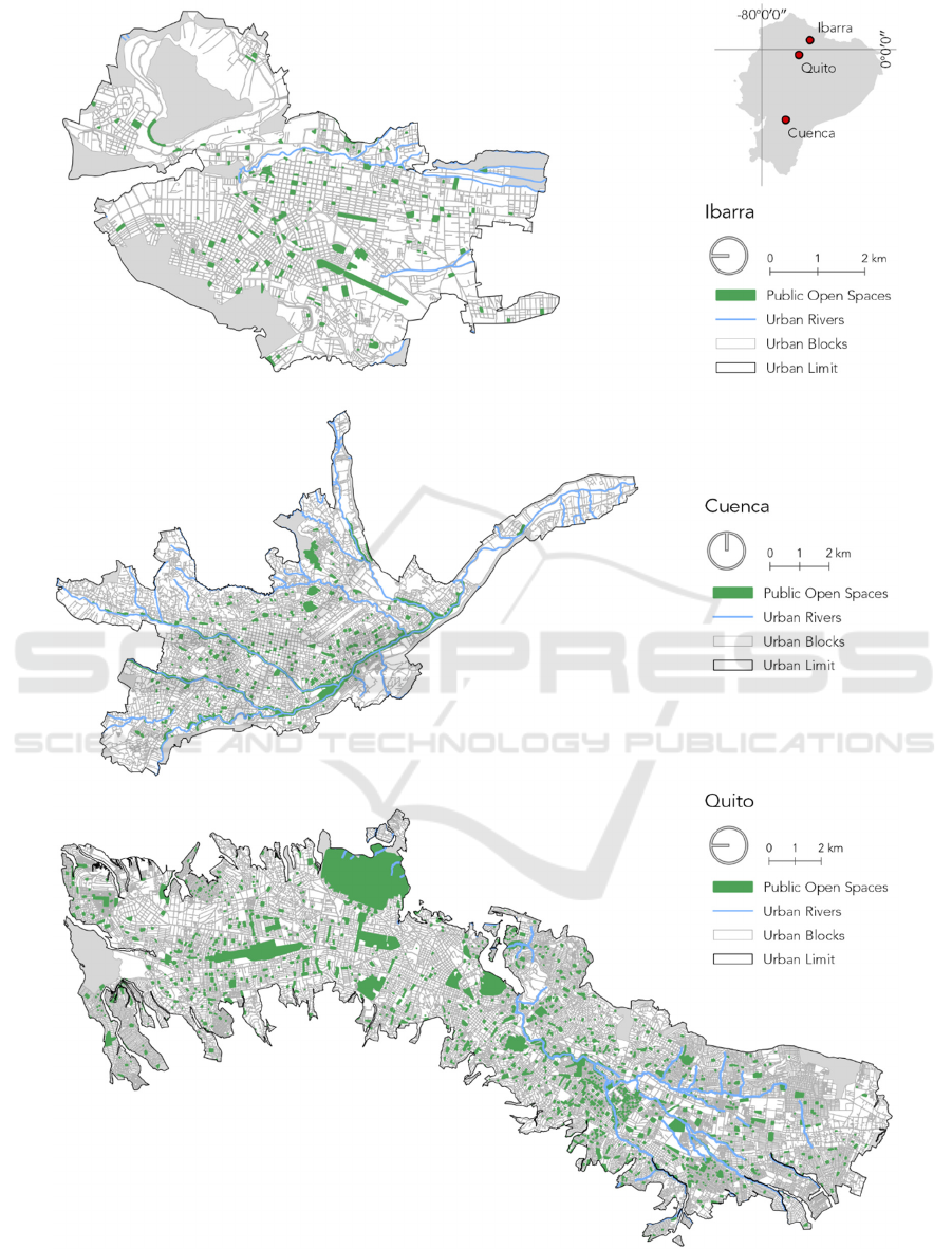
Figure 1: Distribution of Public Open Spaces in Ibarra, Cuenca and Quito.
GISTAM 2020 - 6th International Conference on Geographical Information Systems Theory, Applications and Management
84

Ibarra is the capital of Imbabura province and has
an urban population of 129,305 and a 43.45Km2
extension. Public spaces occupy 1.36Km2 (3.13% of
the total surface). The green urban index is
10.52m2/inhabitant. It is located at the base of the
Imbabura volcano at 2,225 m.a.s.l. and limits with the
Yaguarcocha Lake to the northeast. The closeness to
both the volcano and the lake are to be considered;
however, being a small city, it has not yet reached a
problematic limit regarding natural conditions, which
makes planning decisions timely.
For this analysis only the area inside the official
urban boundary was analysed. The distribution of
POSs in each city is represented in Figure 1.
3.2 Datasets
The unit of analysis is each person in the urban areas
of the three cities. The socio economic condition of
each person was represented by the Living Condition
Index (LCI) (Orellana & Osorio, 2014) of their
corresponding household. The LCI was computed
using official data from the 2010 census (INEC,
2011), which included an identification code of the
city block where the household is located. This code
was used to geo-reference each individual at the block
level. There are no data protection constraints, given
that although the index is calculated per household,
the household’s precise location is unknown, because
census cartography is released up to city block as the
most disaggregated geographical level.
A second dataset contained the public spaces in
each city. First, local authority databases were
obtained. Then, a team in each city revised the
databases, confirming that they corresponded to
existing public sites and updating them to only public
open spaces (leaving aside roofed playing courts, for
example) using aerial imagery and on-site
verification.
Finally, the third dataset comprised the urban
street network of each city obtained from
OpenStreetMap (OpenStreetMap, 2019). The dataset
was revised and corrected for topological consistency
and connectivity.
3.3 Process
First, a pedestrian impedance model was built to
calculate network walking time in minutes for each
street segment and intersection using Network
Analyst in ArcGIS 10.3.. The impedance model was
computed based on the street hierarchy, the existence
of pedestrian infrastructure such as sidewalks and
footways, and the existence of facilities at
intersections, like pedestrian traffic lights or zebra
crossings.
Second, the Living Conditions Index (Orellana &
Osorio, 2014) socio-economic conditions of each
individual was computed in IBM SPSS Statistics 25.0
at the household level. The LCI takes into account
physical household characteristics (flooring, walls
and roofing materials, and overcrowding), access to
basic services (water, electricity, sewage and
communications), level of education of household
dwellers and access to health insurance (public or
private). The spatial location of each individual was
represented as the centroid of the block the household
belongs to. The mean LCI was assigned to each city
block for visual exploratory purposes.
Third, the walking time to the closest POS was
obtained for each individual using the “closest
facility” algorithm in ArcGIS’s Network Analyst.
Usually, origins and destinations are represented by
centroids of polygons (city blocks and POSs).
However, since the algorithm will automatically snap
the centroid to the nearest network edge, centroids of
large POSs (larger than 10000m2) may not be a useful
representation of destinations, because origins at the
other side of the POS will have artificially large
values of network distances and times (the algorithm
will compute the distance as if they must walk all
around the POS to where the centroid was snapped).
Therefore, destinations were represented as points at
the perimeter of each POS each 100m. To select the
perimeter lines that actually have street fronts, a 10-
meter buffer from road centre line was computed,
based on the average width of streets in the three
cities. Then points were generated along the selected
lines each 100m. Finally, large fenced POSs and
those with designated entrances or limited by
topography were individually analysed to determine
their connections to the street network. This approach
implied a considerable pre-processing effort
compared with the traditional method of centroids.
3.4 Statistical Analyses
To assess the potential bias on accessibility to POSs
for different socio-economic levels, the population
was classified into quartiles according their LCI.
Then, the Mood’s Median Test was used to identify if
there were significant differences on the walking time
to the nearest point for different LCI quartiles.
Moreover, Dunn’s post-hoc test with Bonferroni
correction was used for pairwise comparisons.
Boxplots were also used for visual exploration of the
differences. Statistical analyses were conducted in R.
Relation between Proximity to Public Open Spaces and Socio-economic Level in Three Cities in the Ecuadorian Andes
85
Figure 2: Socio-economic conditions for Ibarra, Cuenca and Quito.
GISTAM 2020 - 6th International Conference on Geographical Information Systems Theory, Applications and Management
86
Figure 3: Time to access POS in Ibarra, Cuenca and Quito from each city block.
Relation between Proximity to Public Open Spaces and Socio-economic Level in Three Cities in the Ecuadorian Andes
87

4 RESULTS AND DISCUSSION
4.1 Descriptive Statistics of Proximity
to Public Open Spaces
The mean time in minutes to reach a POS was 4.7 in
Quito, 6.6 in Cuenca and 3.8 in Ibarra. The median
for the three cities was approximately 3 minutes. Also
in all three cities the value for the third quartile is less
than 6 minutes, which means that 75% of people are
about 6 minutes away from a POS. This might seem
encouraging, but as we will discuss further along,
what matters in terms of environmental justice is the
socio-economic profile of those who are further away
and the differences they might have with the rest of
the population. There are some possible causes for
that distribution of POS in each city. In Quito,
planning became important from the 1950s onwards,
under the tradition of the Modern Movement, which
promoted big and small public space reserves before
most Ecuadorian cities experimented rapid growth
(Cifuentes, 2016). The downside of this initial
planning process is that the model was polarized,
segregating (both geographically and economically)
and served the interests of landlords (Carrión &
Erazo, 2012), which planted the seed for the evident
socio-economic divide between the north and the
south that is currently experimented. In Cuenca,
planning also played an important role around the
same time that in Quito, by keeping river banks in a
natural state to be converted into formal POSs later
on (Hermida, Hermida, Cabrera, & Calle, 2015). As
rivers transversally cross the city, mainly from west
to east, the banks became crucial for the POS
distribution. Ibarra, a smaller and younger city, has
experimented horizontal sprawl from the 1980s
onwards, but without replacing previously existing
public spaces for other land uses. Even though the
Table 1: Descriptive statistics of time (minutes) from city
block centroids to the closest POS.
Ibarra Cuenca Quito
Minimum
0.000 0.000 0.000
Maximum
24.679 72.743 95.841
Mean
3.838 6.620 4.712
Median
3.110 3.046 3.224
Standard deviation
3.103 10.264 5.661
Coeff. of Variation
0.808 1.551 1.201
First quartile
1.851 1.579 1.639
Third quartile
4.863 5.982 5.919
average time might be encouraging, the longest time
to the nearest POS in Quito is 95.8 minutes, 72.7
minutes in Cuenca, and 24.7 minutes in Ibarra.
4.2 Socio-economic Spatial Distribution
A spatial pattern of socio-economic conditions
becomes evident: higher levels tend to gather in or
around the city centres, while lower LCI values were
located mainly in the periphery. This pattern is clearer
for Cuenca and Ibarra. Quito, on the other hand,
shows a very strong division by socio-economic
status between the north and the south of the city, the
south being the most disadvantaged one. Blocks with
the lowest LCI are located on the extreme south and
the extreme north of the urban area. See Figure 2 for
details.
Besides this global pattern, there are also small
clusters of high LCI values on peripheral areas. These
are usually modern residential developments where
families with high socio-economic conditions move
to the suburban areas looking for larger parcels and
houses with private gardens or inside gated
communities. There are also clusters and single
blocks of low LCI values near the city centres where
some impoverished neighbours are located.
4.3 Relation between Socio-economic
Distribution and Proximity to
Public Open Spaces
Visual analysis showed that there seems to be a
perceivable bias regarding access to public open
spaces in all three cities, with longer travel times
towards the periphery where blocks with the lowest
socio-economic conditions are usually located.
Figure 3 shows the spatial assignment of each city
block to the closest POS. Although the analysis was
conducted using network distance and walking time,
the assignment of blocks to POSs was represented
using straight lines for the sake of visual
interpretation.
Results of Mood’s median test (Table 2) evidenced
that there are significant differences between the
medians of travel times to POS for different LCI
quartiles in all three cities (alpha = 0,05).
Table 2: Mood’s Median Test Results.
Ibarra Cuenca Quito
X squared
1353.3 6958.7 7541.6
P value
<0.0001 <0.0001 <0.0001
GISTAM 2020 - 6th International Conference on Geographical Information Systems Theory, Applications and Management
88

Table 3: Dunn’s Test Results.
Ibarra Cuenca Quito
Value
q1 q2 q3 q1 q2 q3 q1 q2 q3
z q2 13.519 11.258 44.870
p-value 0.000* 0.000* 0.000*
z q3 20.780 7.270 20.557 9.304 58.843 9.922
p-value 0.000* 0.000* 0.000* 0.000* 0.000* 0.000*
z q4 17.882 4.357 2.920 20.928 9.674 0.370 7.459 36.443 49.191
p-value 0.000* 0.000* 0105* 0.000* 0.000* 1.000 0.000* 0.000* 0.000*
The boxplots showed that, for all cities, people in
the first LCI quartile were further away from a POS
than the people in Q2 and in turn, they were further
compared to people in Q3. These differences were
statistically significant as revealed by Dunn’s test
with Bonferroni’s correction. Quartile Q4, however,
behaved in a different way. Median travel time for Q4
was not significantly different from Q1 in Quito and
from Q3 in Cuenca. In the case of Ibarra, was
significantly higher than for Q3. A possible
explanation might be that dwellers in the best socio-
economic conditions (Q4) don’t prioritize living near
a POS and tend to look for more remote locations with
the possibility of private green space. This might be
due to self-segregation by acquisitive capacity (Table
3 and Figures 4-5).
5 CONCLUSIONS
In this paper we explored the relation between public
space distribution and socio-economic status of the
population in three Ecuadorian cities in the Andes
region. For this purpose, we used a pedestrian
impedance street network model to calculate the
walking time from city blocks centroids to the
entrances to public spaces for different socio-
economic levels. Although people may access to POS
using different transportation means, walking time to
POS will better reflect accessibility for different
socio-economic groups.
There results were consistent on the three cities,
independently of their size and particular historical or
physical conditions. First, although the walking time
to the nearest public space was relatively low from
most city blocks, there was a statistically significant
difference among socio-economic levels. This means
that there is a case of environmental injustice in the
studied cities, regardless of their surface, population
size or particular geographies, a condition that should
be addressed through detailed spatial planning and
Figure 4: Boxplots of time for each socio-economic quartile
(Ibarra-Cuenca).
land use public policy. For example, parcels should
be reserved for public spaces in areas that are in
process of consolidation, with special care for those
Relation between Proximity to Public Open Spaces and Socio-economic Level in Three Cities in the Ecuadorian Andes
89
where the inhabitants have vulnerable socio-
economic conditions. Also, in already consolidated
areas where the need of public space is identified,
some publically owned parcels could be partially or
totally to POSs. Finally, some work can be done with
the community to form public-private alliances for
the provision of POSs and collective spaces.
Figure 5: Boxplots of time for each socio-economic quartile
(Quito).
Second, there is a trend in the three cities in which
walking time to the nearest POS diminishes from the
first to the third LCI quartile. This is, as the socio-
economic condition improves, there are more
accessibility to POSs. However, this trend is
disrupted for the fourth LCI quartile, where the
walking time to the nearest POS increases again or is
not different from Q3, and therefore accessibility to
POSs drops again. Given that their economic status is
not an impediment, it is assumed that distancing from
urban services, like POSs, is intentional which
indicates a trend with an impact on urban growth that
should be properly analysed and addressed. Authors
like Talen (2010) support this affirmation, indicating
that public parks can substitute for private open space
for apartment dwellers, but not for owners of single-
family detached homes, who are likely to have their
own private outdoor space. This pattern is consistent
with the urban sprawl process characterising
Ecuadorian and Latin American cities, where urban
planning is usually weak, producing low-quality
urban neighbourhoods in new expansion areas where
even wealthier families are located. Overall, we were
able to confirm a bias on spatial proximity to POSs
regarding the socio-economic level of population in
the three studied cities.
In methodological terms, one improvement of this
work is that the spatial and statistical analysis was
based on high-detailed datasets. We were able to
assess walking time to nearest POS for each person in
the three cities. Moreover, the representation of
destination as points at the border of the POS instead
of centroids is a more accurate representation for
modelling routes to the closest facility in network
analysis.
Further research could take proximity to POSs to
a deeper level, by analysing accessibility as it was
defined in the Background section of the paper, taking
into account the attractiveness of public spaces and
their relation to space use. At the same time other
accessibility metrics should be explored beyond time-
based proximity (e.g. different transportation modes).
Also, from a planning perspective, potential sites
for public space should be identified in the areas
where the deprived population is, to decrease the bias
against the more vulnerable sectors. Finally, the
methodology could be reproduced to more cities in
the country, and also to other urban services, to
inform public policy.
ACKNOWLEDGEMENTS
This research is part of the project “Estudio
comparativo integral de inventario, distribución y
evaluación del Espacio Público Abierto (EPA) en las
ciudades de Quito, Cuenca e Ibarra” founded by
Pontificia Universidad Católica del Ecuador-PUCE
in collaboration with the LlactaLAB research group
of the University of Cuenca. Authors are grateful with
Prof. Daniela Ballari for her advice on the statistical
analyses.
REFERENCES
Andrade, Jorge; Naranjo, Gabriela; Thodes, Emilio. (2019).
Generación de Criterios para Definición y Clasificación
del Espacio Público Abierto en Ecuador. Manuscript
submitted for publication
Bancroft, C., Joshi, S., Rundle, A., Hutson, M., Chong, C.,
Weiss, C. C. Lovasi, G. (2015). Association of
proximity and density of parks and objectively
measured physical activity in the United States: A
systematic review. Social Science & Medicine, 138,
22–30.
Bolin, B., Matranga, E., Jhackett, E., Ksadalla, E.,
Davidpijawka, K., Brewer, D., & Sicotte, D. (2000).
Environmental equity in a sunbelt city: the spatial
distribution of toxic hazards in Phoenix, Arizona.
Global Environmental Change Part B: Environmental
Hazards, Vol. 2, pp. 11–24. https://doi.org/10.1016/
s1464-2867(00)00010-3
Carrión, F., & Erazo, J. (2012). La forma urbana de Quito :
una historia de centros y periferias *. Bulletin de
GISTAM 2020 - 6th International Conference on Geographical Information Systems Theory, Applications and Management
90

l’Institut Français d’Études Andines, 41(3), 503–522.
Cifuentes, M. (2016). Planificación urbana , modernización
vial y cambios en la vida cotidiana de Quito : el caso del
barrio San Blas , 1967-1973 *. Procesos, 44, 45–74.
Daniels, R., & Mulley, C. (2013). Explaining walking
distance to public transport: The dominance of public
transport supply. Journal of Transport and Land Use,
6(2), 5–20.Fernández-Álvarez, R. (2017). Inequitable
distribution of green public space in the Mexico City:
an environmental injustice case. Economía Sociedad Y
Territorio, p. 399. https://doi.org/10.22136/est002017
697
Giles-Corti, B., Broomhall, M. H., Knuiman, M., Collins,
C., Douglas, K., Ng, K.… Donovan, R. J. (2005).
Increasing walking: how important is distance to,
attractiveness, and size of public open space? American
Journal of Preventive Medicine, 28(2 Suppl 2), 169–
176.
Haq, S. (2015). Urban Green Spaces and an Integrative
Approach to Sustainable Environment. Urban Ecology,
pp. 147–164. https://doi.org/10.1201/b18713-10
Hermida, M. A., Hermida, C., Cabrera, N., & Calle, C.
(2015). La densidad urbana como variable de análisis
de la ciudad . Eure, 41(124), 25–44.
INEC, 2011. Censo de Población y Vivienda 2010.
Ecuador en Cifras.
Ker, I., & Ginn, S. (2003). Myths and realities in walkable
catchments: the case of walking and transit. Road &
Transport Research Journal, 12(2), 69.
Kohn, M. (2004). Brave New Neighborhoods: The
Privatization of Public Space. Routledge.
Koohsari, M. J., Badland, H., & Giles-Corti, B. (2013).
(Re)Designing the built environment to support
physical activity: Bringing public health back into
urban design and planning. Cities, 35, 294–298.
https://doi.org/10.1016/j.cities.2013.07.001
Lotfi, S., & Koohsari, M. J. (2009). Measuring objective
accessibility to neighborhood facilities in the city (A
case study: Zone 6 in Tehran, Iran). Cities, Vol. 26, pp.
133–140. https://doi.org/10.1016/j.cities.2009.02.006
Lynch, K. (1960). The Image of the City. MIT Press.
Mayorga Henao, J. M., & García García, D. M. (2018).
Calidad de vida y acceso inequitativo al espacio público
en Bogotá. Documents d’Anàlisi Geogràfica.
International Chamber of Commerce, 65(1), 69–92.
Mehta, V. (2014). Evaluating Public Space. Journal of
Urban Design, 19(1), 53–88.
OpenStreetMap contributors. (2019). Retrieved
from https://planet.openstreetmap.org
Orellana, D., & Osorio, P. (2014). Segregación socio-
espacial urbana en Cuenca, Ecuador. Analitika, Journal
of Statistical Analysis, 8(2), 27–38.
Pasaogullari, N. (2004). Measuring accessibility and
utilization of public spaces in Famagusta. Cities, Vol.
21, pp. 225–232. https://doi.org/10.1016/s0264-2751
(04)00029-0
Talen, E. (2010). The Spatial Logic of Parks. Journal of
Urban Design, Vol. 15, pp. 473–491. https://doi.org/
10.1080/13574809.2010.502335
Tiznado-Aitken, I., Muñoz, J. C., & Hurtubia, R. (2018).
The Role of Accessibility to Public Transport and
Quality of Walking Environment on Urban Equity: The
Case of Santiago de Chile. Transportation Research
Record: Journal of the Transportation Research Board,
Vol. 2672, pp. 129–138. https://doi.org/10.1177/
0361198118782036
Turner, R.L. and Wu, D.P. Environmental Justice and
Environmental Racism: An Annotated Bibliography
and General Overview, Focusing on U.S. Literature,
1996-2002. Berkeley, CA: Berkeley Workshop on
Environmental Politics, Institute of International
Studies, University of California, Berkeley, 2002.
Available from: digitalcommons.butler.edu/
facsch_papers/575/
Wang, Dong, Brown, Greg and Mateo-Babiano, Derlie
(2013). Beyond proximity: an integrated model of
accessibility for public parks. Asian Journal of Social
Sciences & Humanities 2 (3) 486-498
Wen, M., Zhang, X., Harris, C. D., Holt, J. B., & Croft, J.
B. (2013). Spatial disparities in the distribution of parks
and green spaces in the USA. Annals of Behavioral
Medicine: A Publication of the Society of Behavioral
Medicine, 45 Suppl 1, S18–S27.
Wolch, J. R., Byrne, J., & Newell, J. P. (2014). Urban green
space, public health, and environmental justice: The
challenge of making cities “just green enough.”
Landscape and Urban Planning
, Vol. 125, pp. 234–
244. https://doi.org/10.1016/j.landurbplan.2014.01.017
Relation between Proximity to Public Open Spaces and Socio-economic Level in Three Cities in the Ecuadorian Andes
91
