
Towards Real Estate Analytics using Map Personalisation
Mariam Mubarak
1
, Kamran Khalid
1
, Fizza Waqar
2
, Ali Tahir
1
, Ibraheem Haneef
3
,
Gavin McArdle
4
and Michela Bertolotto
4
1
Institute of Geographical Information Systems, National University of Sciences and Technology, Islamabad, Pakistan
2
GIS Plus Total Solutions, Islamabad, Pakistan
3
Dept. of Mech & Aerospace Engg, Air University, Islamabad, Pakistan
4
School of Computer Science, University College Dublin, Dublin 4, Ireland
ibraheem.haneef@mail.au.edu.pk, {gavin.mcardle, michela.bertolotto}@ucd.ie
Keywords: Real Estate, Map Personalisation, Map Recommendation, Implicit Profiling, Estatech Maps, Real Estate
Analytics.
Abstract: The value of global real estate was $217 trillion in 2015 which is 2.7 times world GDP, making up roughly
60% of mainstream global assets and consequently it is considered one of the main drivers of economic
growth. The availability of geospatial big data can assist real estate stakeholders to make informed decisions
and increase their profits. Location plays a significant role in real estate decision making and so maps
represent an excellent resource for real estate planning. Personalisation can assist with real estate decisions
by ascertaining a user’s interests and preferences which can be captured via interaction with maps. A
personalised real estate portal can then use this information to recommend properties on the web aiding
property buyers and provide valuable real estate analytics. In this paper, we propose an approach for a
personalised real estate platform called Estatech Maps. This will be a pioneer in the real estate industry, the
key focus of which is to alter the prevailing management practices by imparting GIS and data analytics as
long-term solutions.
1 INTRODUCTION
Global real estate investment volumes are increasing
steadily
1
. While some signs of decline are currently
being observed, for example, in the UK due to
Brexit and in Jakarta due to a new capital formation,
many of the other major capital cities (particularly in
the Asia Pacific region) are showing a rising trend.
“The global real estate value was $217 trillion in
2015 which at that time was 2.7 times the world
GDP, making up roughly 60% of mainstream global
assets”
2
.
Moreover, investors in real estate are concerned
about the overestimation of the property prices in
comparison to its long-term value. Indeed whenever
and wherever prices are well above their long-term
value the investor should adopt a strategic approach
of lowering the risk of an incorrect investment
1
https://www.imf.org/external/research/housing/index.htm
2
https://www.valuewalk.com/2016/01/global-real-estate-
value/
against the opportunity to make a small investment
goes a long way. To assist with this decision an
investor should have the right tools. There are
currently many online real estate portals and web
applications which provide users with relevant data
for any real estate investment decision.
The real estate industry still has to mature when
it comes to combining both artificial intelligence
(AI) with humans in the loop judgments to make
suggestions for investment. There are organizations
and start-ups involved in research and its consequent
development may have the tendency to eventually
become a major breakthrough in advancing real
estate portals to a much more mature level.
There has been some technology mediated
innovation in the real estate market. For example,
the leading Australian property portal
realestate.com.au has a business model which is
based on creating competitive tension in the market
3
.
The idea revolves around elevating a real estate item
3
https://www.realestate.com.au/buy
184
Mubarak, M., Khalid, K., Waqar, F., Tahir, A., Haneef, I., McArdle, G. and Bertolotto, M.
Towards Real Estate Analytics using Map Personalisation.
DOI: 10.5220/0009368301840190
In Proceedings of the 6th International Conference on Geographical Information Systems Theory, Applications and Management (GISTAM 2020), pages 184-190
ISBN: 978-989-758-425-1
Copyright
c
2020 by SCITEPRESS – Science and Technology Publications, Lda. All rights reserved

as a premium sale item and making it desirable in all
aspects. The model ensures that paid advertisement
by the investor gets the property listing at the top of
the web page. Nowadays the use of maps to show
the location of properties and nearby facilities is a
common practice. A UK based platform called
Rightmove focuses on customers’ interaction with
the property listings. In this case every aspect of the
product is mentioned clearly along with the option
of interactive maps where users can outline areas of
interest and view listed properties
4
. Daft, an Irish
based real estate platform also uses an interactive
map for selecting property items
5
. A US based
platform called Trulia distinguishes its services in
terms of providing richer map features such as
neighbourhood overview for the selected area along
with providing spatial information for nearest
utilities and crime rates in the area
6
.
Another portal with a detailed map view of all
the property listings, features and relevant tools is
Realtor. The website has extensive listings with
detailed filtering and multiple calculators for
mortgage, re-finance, how much one can afford, rent
vs. buy and find my buying power. The listings on
the map are displayed in terms of price tooltips
which are colour coded as well. The map has
separate layers for schools, crime, lifestyle and
transit which when selected is displayed along with
the selected listings layer
7
.
Given the massive real estate target market, our
emphasis is on automation at micro level of real
estate business procedures and practices. The main
aspect of creating a web portal for personalized real
estate maps is based on how accurately our system
develops user profiles. The system creates profiles
based on methods such as implicit and explicit
profiling techniques (Mac Aoidh et al, 2007).
Implicit profiling considers the movements of the
mouse cursor and the interaction of the user with a
system where as explicit profiling technique gathers
data when the user provides the feedback explicitly
about their preferences. In both scenarios the
profiling of the user takes place based on the
conduct of the user and the set of
collaborative/interactive data that is generated after a
session. As a result the system can offer response to
the user, by visualizing the outcomes of the
computation initiated by user activities. Based on
our research, the proposed real-estate portal is
distinctive which uses such profiling techniques
4
https://www.rightmove.co.uk/
5
https://www.daft.ie/
6
https://www.trulia.com/
7
https://www.realtor.com/
which will provide services for the customer and
insight for the real estate company.
2 RELATED WORK
Exponential increase in spatial information and its
consequent storage has been a continuous area of
concern (Dragicevic et al, 2016). The massive
amount of information to be displayed on digital
maps makes the extraction of useful content a
tedious task. Personalization techniques are one of
the most optimized ways of eliminating these
problems. Research in this area focuses on
developing profiling techniques for individuals and
reducing the overall cognitive load (Stiller et al,
2009). Furthermore, building upon this is the
dimension, extensively explored in profiling,
regarding the division of the problem into sub-tasks
which in turn improves the efficiency and accuracy
of the system (Guy, 2017).
Several sub tasks have been devised such as
profile extraction, profile integration and user
recommendations through which propositions are
made to deal with the profiling task. A TCRF (Tree
Structured Random Conditional Fields) algorithm
has been proposed which helps in the extraction of
profile data from the already available web
documents. The algorithm devised acquires data
through implicit profiling techniques, through which
the data is acquired from the user anonymously as
per the user’s interest and location information
(Tang et al, 2007). LCARS (Location content aware
recommendation system) provides the user a set of
recommended items based on the location of the
user and through its offline mode it learns the
interests of the user and produces the top
recommended items (Yin et al, 2014) Applied
examples include RecoMap which is a portal
through which every user gets recommendations
based on their preferences and the results are in the
form of a map interface highlighting the user’s
choice and corresponding personalized spatial
recommendations. The adaptive map also highlights
user’s preference as well as context which are both
perceived implicitly (Ballatore et al, 2010). Another
similar study which considers user mouse
movement, GPS trajectories and subsequent
extraction of useful data which in turn analyses
which information can become a part of
recommendation system (Huang and Gartner, 2014).
These approaches have not been widely used in the
property domain.
Towards Real Estate Analytics using Map Personalisation
185

Recommendation based on a case-based
reasoning methodology has been introduced to the
real estate domain for personalisation (Alrawhani et
al, 2016). Both approaches provide accurate results.
The methods used in these approaches utilise an
iterative process for refining the search criteria in
order to provide polished results to the end user. End
users can provide feedback to classify if the
recommendations are useful. A similar approach
which aims to reduce the computational cost relies
on the concept of combining or grouping similar sets
of users (Kanoje et al, 2015). This aims to help with
the cold start problem of recommender systems so
that when a new user starts using the system or if the
user is in an unlogged session, suggested content
based on the nearest neighbour is displayed (Pereira
and Hruschka, 2015).
Further technological advances in the real estate
domain come in the form of so called smart real
estate investment there is an emphasis on the use of
technologies such as drones, internet of things (IoT),
cloud, software as a service (SaaS), big data, 3D
scanning, wearable technologies, virtual and
augmented realities (VR and AR), artificial
intelligence (AI) and robotics in order to make
decisions which can avoid any bad return on
investment (Ullah et al, 2018). However, when it
comes to making real time smart investments in real
estate, there is a need for a multi criteria evaluation
model for selection of an optimal real estate
investment. The model needs to account for the
factors of alternative options, variant selection and
investment resource allocation (Ginevicius and
Zubrecovas, 2009).
Smart real estate investment is not void of
threats designed for a theoretical reference model for
residential real estate risk assessment using fuzzy
cognitive mapping. This fuzzy model makes it
possible to define and better understand the cause-
and-effect relationships between determinants, thus
allowing better informed investment decisions. The
results show that the use of cognitive maps reduces
the number of missing criteria and facilitates focus
on how the criteria relates with each other. (Ribeiro
et al, 2017).
We suggest a “Multi-Attribute Cogency
Method” which takes into account the four basic
attributes through which a buyer and seller both can
make clear and winning decisions about their
investment and return on investment. These
attributes include Cost, Utilities, Transport and
Environment. These have sub-attributes associated
with them as well based on which any user of the
portal is able to make a decision which can ensure
an effective outcome.
To the best of our knowledge, real estate map
personalisation is an emerging research domain with
relatively less research work in this field.
3 METHODOLOGY
The real estate market is continually evolving and
various factors must be understood. It has become a
necessity to develop new analytical tools and
methods within this emerging area. Our focus is on
basic attributes of a property item through which a
buyer can make clear and objective decisions about
their investment. These attributes include
characteristics of the property and utilities. There are
sub-attributes associated with them such as cost,
size, facilities around the property etc. based on
which any user of our proposed real estate portal,
Estatech Maps, is able to make a decision, which
may ensure an effective outcome. Estatech Maps is
an extension of Estatech, which is more of an ERP
(Enterprise Resource Planning), commercially
available product built on open source technologies.
The web application we propose makes suggestions
and recommendations based on user profiling
techniques, which provide an interactive map-based
experience. The following section describes the
complete system flow, proposed profiling methods
and the open source technology stack.
3.1 System Description
Estatech Maps is a web based real estate portal
which presents properties for sale and rent to end
users. A map is used to display property locations
and features. The portal allows simple search
options such as search by city, society (a planned
settlement comprising of all essential living
facilities), sector or block. Furthermore, using the
advanced search option the user can refine the
criteria by selecting options such as area or size,
number of bedrooms, type (house or apartment),
price etc. Search for nearby properties allows the
user to see properties around them on the map which
are under the radius of say 5km (radius can be
customized). The show path option displays the
shortest route between the user’s current location
and the selected property. This usage data is utilized
to form a user profile. The profile is used to drive a
personalization feature to produce relevant
recommendations for the end-user. The profile also
provides user analytics for estate agents.
GISTAM 2020 - 6th International Conference on Geographical Information Systems Theory, Applications and Management
186

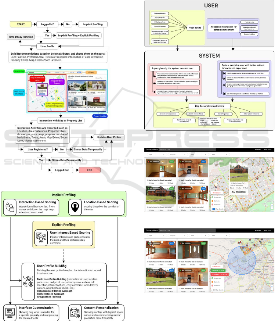
The proposed workflow of the system is
illustrated in Figure 1. It describes the process for
the case when the user profile exists as well as when
it does not. If a user is not logged in then the
profiling is done implicitly, otherwise both implicit
and explicit profiling is performed for building the
user profile. The user profile keeps on updating with
a time-decay function which places more emphasis
on recent interactions with the system to generate
recommendations for the user. The recommenda-
tions are built on attributes such as user position,
preferred area, filters set for the properties, map
extent, zoom level, saved properties and previous
interactions of the users with the system. The users
interact with the map or the listings of the property
and a user profile is generated and updated
accordingly, if the user is registered then the
interaction data is stored permanently otherwise the
data is stored temporarily until the user session ends.
3.2 User Profiling
Multiple approaches can be followed for building the
user profile however based on our research explicit,
implicit and group based profiling techniques will be
adopted, which have not been implemented at this
stage but will be part of the final system. One of the
most fundamental aspects of system development is
reduction of computational cost which is done
through “group profiling technique”. The technique
serves the purpose of delivering quick results, but the
accuracy or quality of those results may vary since the
results are not based on a specific user but represent
combined group preferences.
The user implicit and explicit profile building
approaches can be seen in detail in Figure 2, implicit
profiling can be termed as profile evolution and
explicit profiling as profile determination. After
implicit and explicit profiling are performed
collaborative filtering approach is adopted which
involves predicting preferences or choices.
Collaborative filtering (Schafer et al, 2007) method
uses the known partialities of a set of prior users to
suggest recommendations for the next set of users.
This approach assists system which in turn would be
able to generate group profiles of the user by
combining those individual user profiles which have
similar interests (Herlocker et al, 2004). A detailed
explanation of the interaction between the user and
the suggested system on the basis of user inputs is
shown in Figure 3. The system aids the user by
providing personalized recommendations based on
the set preferences which were learnt by the system
using implicit or explicit techniques.
3.3 Technology Stack
The technology stack being used to develop Estatech
Maps comprises of a framework and multiple
libraries. On the client side we have used LeaftletJS
8
for visualization of spatial data, which are
properties, schools, hospitals and the current
location of the user. Open street map (OSM) is used
as the background base map. Moreover, the
prototype uses TurfJS
9
for the spatial analysis of the
data; in particular it is being used to filter properties
near the user’s current location. Axios
10
is being
used for data acquisition from the database. VueJS
11
is the front-end framework, which is being used for
building the user interface, with the plugin Vuetify
12
to give the application a material design appearance.
The application is running on a VM instance on
amazon cloud
13
and the database is PostgreSQL
14
.
4 DISCUSSION
The initial prototype of the portal yielded optimum
results along with successful testing of certain
features such as filters, buffer around the user's
location, route buffers for the user to assist in
selecting the best available property. Figure 4 shows
the initial concept and design of the interface. The
right side shows the interactive map section while
the left panel displays the property items which
match the user’s criteria. The filtering can be done
based on property type, purpose, number of rooms,
property size. Whereas a customisable buffer will be
generated as per the user’s current location (if
allowed by user), visualizing the filtered properties
on the map within the user’s immediate area of
interest as depicted in Figure 5. The size of the
buffer can be changed as per the user’s requirement.
4.1 Web Application Features
An innovative feature of Estatech Maps is
“properties on the go” option through which a user
can find a route towards a selected property. The
path will be calculated and shown on the map and
similar properties nearest to the user’s route which
8
https://leafletjs.com/
9
https://turfjs.org/
10
https://www.npmjs.com/package/axios
11
https://vuejs.org/
12
https://vuetifyjs.com/en/
13
https://aws.amazon.com/cloudfront/
14
https://www.postgresql.org/
Towards Real Estate Analytics using Map Personalisation
187
match the user profile will also become visible on
the map as shown in Figure 6. Other features which
are included are area selection on the basis of
presence of basic utilities like supermarkets, schools
and hospitals as well as heat maps depicting the
areas where there is a higher concentration of
properties for sale. Depictions of properties with
price visibility on the map along with the trends of
any price reduction are also available. Estatech
Maps is also optimized for use on mobile devices.
Figure 1: User session and recommendation process.
Figure 2: User profile building process.
Additionally, the features which will be added as
the portal matures will comprise of individual map
view for the user which will be based on what type
of interest user has whether it’s only for property
decrease trends, property value below the market
locations or the interest level lies only in areas which
are in pre-development stage etc.
Figure 3: User and system interaction.
Figure 4: Main interface real estate map portal.
Figure 5: Real estate map portal with basic spatial
analysis.
GISTAM 2020 - 6th International Conference on Geographical Information Systems Theory, Applications and Management
188

Figure 6: A tool for “on the go” suggestions for matching
properties.
5 CONCLUSIONS
This real estate portal will bring forward an
exceptional experience for the stakeholders of this
domain in order to select, manage and handle
properties. The strength of the recommendation
system and the accurate user profile building are the
core components of this portal. The next step to
evaluate the impact of Estatech Maps is with the use
of AI and ML algorithms (Syam and Sharma, 2018;
Shahhosseini et al, 2019). Machine learning
approaches for real estate can be categorized based
on specific objectives, including: finding the market
value of a building, predicting long term value
(LTV) of new listings, predicting value of property,
classification of seller score, predicting time to
close, effective lead management.
Prediction making systems in the real estate are
in developing stages and machine learning
algorithms which can be utilized for the purpose of
predicting the current and future prices of the
properties are: ANN, support vector machines, k-
nearest neighbours and regression trees (Ottomanelli
et al, 2014). Specifically, our system can be further
enhanced by the use of Artificial Neural Networks
(ANNs) which are beneficial in developing input-
output relations, acquiring data from existing real
estate statistics, the model proposed to be used for
evaluation is KERAS model which is a high-level
neural networks API written in Python. The
capability of this model can be very beneficial in
complicated systems like real estate where rationale,
perceptions and existing resources do not tend to
obey coherent course of actions.
Whereas machine learning approaches for real estate
can be categorized as: finding the market value of a
building, predicting long term value (LTV) of new
listings, predicting value of property, classification
of seller score, predicting time to close, effective
lead management are some of the approaches which
can be effectively determined. Similarly, the ethical
and privacy issues implementation are left for future
work.
ACKNOWLEDGEMENTS
This research was supported by the Higher
Education Commission (HEC), Pakistan under grant
no. TDF03-249. The authors gratefully acknowledge
their support.
REFERENCES
Mac Aoidh, E., Bertolotto, M., & Wilson, D. C. (2007).
Implicit Profiling for Contextual Reasoning About
Users' Spatial Preferences. In CaCoA.
Li, S., Dragicevic, S., Castro, F. A., Sester, M., Winter, S.,
Coltekin, A.,& Cheng, T. (2016). Geospatial big data
handling theory and methods: A review and research
challenges. ISPRS Journal of Photogrammetry and
Remote Sensing, 115, 119-133. challenges", {ISPRS}
Journal of Photogrammetry and Remote Sensing.
Stiller, C., Roß, F., & Ament, C. (2009). Towards spatial
awareness in recommender systems. In 2009
International Conference for Internet Technology and
Secured Transactions, (ICITST) (pp. 1-7). IEEE.
Guy, N. N. (2017). A Recommender system for rental
properties (Doctoral dissertation, Strathmore
University).
Tang, J., Hong, M., Li, J., & Liang, B. (2006). Tree-
structured conditional random fields for semantic
annotation. In international semantic web conference
(pp. 640-653). Springer, Berlin, Heidelberg.
Yin, H., Cui, B., Sun, Y., Hu, Z., & Chen, L. (2014).
LCARS: A spatial item recommender system. ACM
Transactions on Information Systems (TOIS), 32(3),
11.
Ballatore, A., McArdle, G., Kelly, C., & Bertolotto, M.
(2010). RecoMap: an interactive and adaptive map-
based recommender. In Proceedings of the 2010 ACM
Symposium on Applied Computing (pp. 887-891).
ACM.
Huang, H., & Gartner, G. (2014). Using trajectories for
collaborative filtering-based POI recommendation.
IJDMMM, 6(4), 333-346.
Alrawhani, E. M., Basirona, H., & Sa'ayaa, Z. (2016).
Real Estate Recommender System Using Case-Based
Reasoning Approach. Journal of Telecommunication,
Electronic and Computer Engineering (JTEC), 8(2),
177-182.
Kanoje, S., Girase, S., & Mukhopadhyay, D. (2015). User
Profiling for Recommendation System. arXiv preprint
arXiv:1503.06555.
Pereira, A. L. V., & Hruschka, E. R. (2015). Simultaneous
co-clustering and learning to address the cold start
Towards Real Estate Analytics using Map Personalisation
189

problem in recommender systems. Knowledge-Based
Systems, 82, 11-19.
Ullah, F., Sepasgozar, S. M., & Wang, C. (2018). A
systematic review of smart real estate technology:
Drivers of, and barriers to, the use of digital disruptive
technologies and online platforms. Sustainability,
10(9), 3142.
Ginevičius, R., & Zubrecovas, V. (2009). Selection of the
optimal real estate investment project basing on
multiple criteria evaluation using stochastic
dimensions. Journal of business economics and
management, 10(3), 261-270.
Ribeiro, M. I., Ferreira, F. A., Jalali, M. S., & Meidutė-
Kavaliauskienė, I. (2017). A fuzzy knowledge-based
framework for risk assessment of residential real estate
investments. Technological and Economic
Development of Economy, 23(1), 140-156.
Schafer, J. B., Frankowski, D., Herlocker, J., & Sen, S.
(2007). Collaborative filtering recommender systems.
In The adaptive web (pp. 291-324). Springer, Berlin,
Heidelberg.
Herlocker, J. L., Konstan, J. A., Terveen, L. G., & Riedl,
J. T. (2004). Evaluating collaborative filtering
recommender systems. ACM Transactions on
Information Systems (TOIS), 22(1), 5-53.
Syam, N., & Sharma, A. (2018). Waiting for a sales
renaissance in the fourth industrial revolution:
Machine learning and artificial intelligence in sales
research and practice. Industrial Marketing
Management, 69, 135-146.
Shahhosseini, M., Hu, G., & Pham, H. (2019). Optimizing
Ensemble Weights for Machine Learning Models: A
Case Study for Housing Price Prediction. In
INFORMS International Conference on Service
Science (pp. 87-97). Springer, Cham.
Ottomanelli, Michele & Chiarazzo, Vincenza & Marinelli,
Mario & Caggiani, Leonardo. (2014). A Neural
Network based Model for Real Estate Price Estimation
Considering Environmental Quality of Property
Location. Transportation Research Procedia. 3. 810-
817. 10.1016/j.trpro.2014.10.067.
GISTAM 2020 - 6th International Conference on Geographical Information Systems Theory, Applications and Management
190
