
A Cloud Architecture for Processing and Visualization of
Geo-located 3D Digital Cultural Heritage Models
Ikrom Nishanbaev
a
School of Media, Creative Arts and Social Inquiry, Curtin University, Perth, WA 6845, Australia
Keywords: Web-GIS, Geo-located 3D Cultural Heritage Models, 3D Visualization, Web Repositories for 3D Models,
Cultural Heritage.
Abstract: The increasing affordability of surveying methods such as laser scanning and photogrammetry has aroused
broad and current interest in 3D modelling among cultural heritage preservation specialists. This generated,
in recent years, many digital cultural heritage preservation projects across the globe that aimed at documenting
cultural heritage sites and objects in a 3D form. Once 3D cultural heritage models have been created, the next
step is generally to assure their long-term digital storage, dissemination, and visualization. To this end, this
article presents a new cloud architecture for processing and visualization of geo-located 3D cultural heritage
models over the web, which has been accomplished by integrating maps, 3D cultural heritage models, and the
geospatial data associated with the location of 3D cultural heritage models. The cloud architecture is based
on Amazon Web Services, while the core framework for handling the content is managed by free and open-
source, database-driven, easy-to-implement KeystoneJS Content Management System. All other frameworks
used in the architecture such as for web mapping, 3D visualization, etc. are also based on free and open-source
paradigm, which allows flexibility on extensions and re-use. The proposed architecture has been validated
through a use-case applied to Australian 3D cultural heritage models.
1 INTRODUCTION
In recent years, 3D modelling has become a
widespread tool among CH preservation specialists.
One of the reasons for this is the increasing
affordability of surveying methods such as laser
scanning and photogrammetry, which can efficiently
and accurately survey tiny cultural heritage (CH)
objects as well as complex CH sites (Remondino,
2011). This generated, in recent years, many digital
CH preservation projects across the globe to
document CH objects and sites in a 3D form
(D'Andrea, Niccolucci, Bassett, & Fernie, 2012). The
resulting 3D CH models are often employed not only
for preservation purposes but also for other purposes
such as 3D Geographic Information Systems (GIS),
augmented reality, and virtual reality among others
(Campanaro, Landeschi, Dell’unto, & Leander
Touati, 2016). Furthermore, there are cloud
computing-based web repositories, web-GIS
platforms, and archives are emerging for long-term
storage, visualization, and analysis of 3D digital CH
a
https://orcid.org/0000-0003-0032-3283
models. Cloud computing offers many benefits over
traditional approaches (e.g. on-premise
infrastructure) such as scalability, flexibility, and
potential to reduce IT (information technologies)
costs among others. Scalability of the cloud
computing refers to the ability of the system in which
every application or infrastructure can be scaled up
and scaled down based on the workload (Falatah &
Batarfi, 2014; Lee & Kim, 2010; Singh & Malhotra,
2012). While flexibility in cloud computing allows
employees to be more flexible in terms of accessing
files through web browsers, collaboration, access
from different devices and location among others
(Bharadwaj & Lal, 2012; Sultan, 2014). Finally, IT
costs can be reduced through a reduction in spending
on hardware, software, infrastructure, and IT staff
among others (Chandra & Borah, 2012; De Assunção,
Di Costanzo, & Buyya, 2009).
Despite the fact that there are some web platforms
and archives for 3D content such as OMEKA, 3D-
COFORM, Sketchfab, TurboSquid, 3D CH models
are still problematic to find, use and re-use. A recent
Nishanbaev, I.
A Cloud Architecture for Processing and Visualization of Geo-located 3D Digital Cultural Heritage Models.
DOI: 10.5220/0009341500510061
In Proceedings of the 6th International Conference on Geographical Information Systems Theory, Applications and Management (GISTAM 2020), pages 51-61
ISBN: 978-989-758-425-1
Copyright
c
2020 by SCITEPRESS – Science and Technology Publications, Lda. All rights reserved
51

survey of Champion and Rahaman (Champion &
Rahaman, 2019), who surveyed 14 proceedings of
leading digital heritage events and conferences,
revealed that out of 1483 examined conference
articles only 17.9% or 264 articles incorporated 3D
models or images of 3D models. Even more dramatic
is only 9 articles had accessible 3D content.
Furthermore, in most cases, 3D digital CH models
incorporate geospatial information relating to the
location of the CH site and object.
To this end, this article presents a new cloud-
based architecture for integrating maps, 3D digital
CH models and geospatial data such as geolocation.
The cloud architecture is based on Amazon Web
Services (AWS), while the core framework for
handling the content is managed by free and
open-source, database-driven, easy-to-implement
KeystoneJS Content Management System (CMS).
All other frameworks used in the architecture such as
for web mapping, 3D visualization, etc. are also based
on free and open-source paradigm, which allows
flexibility on extensions and re-use. The proposed
architecture has been validated through a use-case
applied to Australian 3D CH models. This
architecture can be used, or extended for use, in a
wide range of domains including GIS.
The contributions of this article to the CH and GIS
domains are as follows:
• A new AWS-based cloud architecture to
integrate maps, 3D CH models and geospatial
data such as geolocation. All employed
frameworks in the architecture are free and open-
source, and completely extendable and reusable.
The proposed architecture can also be used in any
other cloud platform, which supports Node.js
environment.
• Since content management including uploading
and editing text data, 3D CH models, and geo-
location within the architecture is based on a
database-driven, easy-to-implement KeystoneJS
CMS, it can help CH and GIS professionals with
limited technical knowledge to implement the
architecture. Furthermore, many time-
consuming web developments such as admin
user interface, session management among
others are handled by the KeystoneJS CMS.
• CH organizations and institutions such as
museums, galleries, and archives can implement
this architecture to present available CH objects
and assets in a 3D digital form on the web. This
can, in turn, help to promote national and
international tourism.
• GIS and CH professionals can extend this
architecture according to their needs. For
instance, raster and vector data can be integrated
with the free and open-source framework of
GeoServer, which supports geospatial data in
many formats and standards.
• Finally, the article extends the existing body of
knowledge and expertise in implementing a
cloud-based architecture for processing and
visualization of geo-located 3D digital models.
2 RELATED WORK
Europeana is a CH platform and aggregator with
more than 30 million digitized objects from more than
2300 European CH institutions and organizations,
while Europeana cloud is one of the largest projects
regarding cloud-based infrastructures for CH
research and data. Europeana Cloud is an initiative by
Europeana Foundation to provide shared cloud
infrastructure for aggregating and exchanging CH
data among European institutions and organizations.
To this end, it offers many services such as unique
identifiers to each CH records, storage and access for
heterogeneous CH data including metadata,
annotation services to add additional data to CH
records, tracking of changes made to CH records,
flexible, scalable and customizable CH data
processing capabilities among others. Europeana
cloud, in terms of technical architecture, has been
implemented on a hybrid cloud architecture by
combining public cloud and private cloud
architectures. This allows taking all the advantages
offered by these two cloud architectures. For instance,
public cloud offers flexibility for scaling up and down
the hardware capabilities based on the workload,
while the private cloud offers more resistance to
failures and less dependency on third-party cloud
providers to name a few (Benardou, Dallas, &
Dunning, 2014; Kats et al., 2014).
The SACHER (Sacher-Project) (The Smart
Architecture for Cultural Heritage in Emilia
Romagna) is a project financed by Regione Emilia-
Romagna within the European Regional
Development Fund. It has developed a cloud-based,
open-source and federated platform to manage
various aspects of tangible CH such as 3D life cycle
management for CH, the multi-dimensional search
engine to find CH data from heterogeneous sources
among others. The platform offers services both to
CH professionals and the public. The cloud platform
used in the project is IaaS (Infrastructure-as-a-
service) OpenStack, which is often used to build
private and public clouds. Regarding the server-side
web technology, the project uses the Django web
GISTAM 2020 - 6th International Conference on Geographical Information Systems Theory, Applications and Management
52

framework, which is written in Python programming
language. Swift Object Storage was employed as a
storage container for 3D models, while 3D Heritage
Online Presenter (3DHOP) was chosen as a
visualization framework for 3D models. The multi-
dimensional search engine in the platform is based on
a NoSQL database of MongoDB. The platform also
incorporates a Google map through which CH places
can be searched by name, address and building type
(Apollonio et al., 2017; Bertacchi et al., 2018).
CNR ITAB (Institute for technologies applied to
cultural heritage), while collaborating with
ARIADNE (Ariadne-Infrastructure-Project) and E-
RIHS (E-RIHS-Project) infrastructure projects,
developed a cloud-based modular architecture to
enable archeologists to build and visualize 3D
landscapes. This architecture was built on a cloud
platform of ownCloud (ownCloud), which comes in
three versions namely ownCloud Community,
ownCloud Online, and ownCloud Enterprise. In all
versions, it provides a free desktop client and iOS and
Android app to upload and manage the data. The
developed cloud architecture offers several services
such as terrain service and gallery service. The former
leverages on WebGL based Virtual Planet Builder
(Virtual-Planet-Builder) tool to load, process and
visualize GIS elevation data such as Digital Elevation
Models (DEM). The latter service allows users to
create, delete, and update projects within the system.
It displays all created terrain databases, status, and if
available, a short description for each entry among
others (Fanini, Pescarin, & Palombini, 2019).
Furthermore, there are some other smaller-scale
projects in this regard such as a collaborative project
by the National Library of Scotland, Edinburgh
Parallel Computing Centre, the National Galleries of
Scotland and the Digital Preservation of Coalition.
The name of the project is Cloudy Culture, which
aimed to investigate the potential of EUDAT
(EUDAT) cloud services in CH conservation,
particularly to improve preservation and accessibility
of European CH data hosted in the National Library
of Scotland, and the National Galleries of Scotland.
These two CH institutions collect and host an
extremely large amount of digital CH data such as
maps, books, articles, images among others, which
require safe digital preservation (EUDAT).
Another relating project is by Pisu and Casu
(2013), which proposed a cloud-based web-GIS
framework for documentation and dissemination of
architectural heritage. The web-GIS framework
resulted in a multi-scale and multi-layer information
system applied to Sardinian late gothic architecture.
3 BACKGROUND LITERATURE
3.1 Cloud Computing
Cloud computing is the hosting and the delivery of
various services over the Internet. It can include tools
and resources such as servers, databases, networking,
various business applications and software, which can
be leased in an on-demand fashion. Cloud computing
has been given many definitions, however, many
researchers and professionals in this domain have
adopted a definition by the National Institute of
Standards and Technology of the United States
(NIST), which states it as follows:
‘Cloud computing is a model for enabling
convenient, on-demand network access to a shared
pool of configurable computing resources (e.g.,
networks, servers, storage, applications, and
services) that can be rapidly provisioned and
released with minimal management effort or service
provider interaction.’
Cloud computing services can be grouped into
three categories namely software as a service (SaaS),
platform as a service (PaaS), and infrastructure as a
service (IaaS).
SaaS refers to cloud computing that offers on-
demand applications over the Internet. An apt
example of this category of cloud computing is
Salesforce (Salesforce), which offers a wide range of
services to business owners (customer relationship
management) to better connect with customers,
potential customers, and partners.
PaaS refers to cloud computing that offers
platform resources such as software development
frameworks and tools. An example of this category of
cloud computing is Heroku (Heroku). It provides
software developers with virtual containers called
‘Dynos’ that can execute software applications
written in various programming languages.
IaaS refers to cloud computing that offers on-
demand infrastructural resources over the Internet.
Examples of this category of cloud computing include
Amazon Elastic Compute Cloud - Amazon EC2
(Amazon-EC2), Google Compute Engine (Google-
Compute-Engine) and Digital Ocean (DigitalOcean)
among others. This cloud computing type allows
launching on-demand virtual machines (VMs), which
can then be accessed to perform computing tasks.
Cloud computing also offers several cloud
deployment models, which define how cloud services
are made available to users. Public cloud, private
cloud, hybrid cloud, and community cloud are 4
common deployment models associated with cloud
computing.
A Cloud Architecture for Processing and Visualization of Geo-located 3D Digital Cultural Heritage Models
53

Public cloud is the type of cloud computing model
that supports all users who want to use cloud
computing resources such as hardware and software
on a subscription basis, in other words, everyone who
subscribed can use the services. It is often used for
application development and testing, file sharing and
other purposes, in which privacy and security of data
are not a high priority.
On the other hand, the private cloud is typically
used by a single organization. This type of cloud
computing deployment can be hosted internally or
externally. This type of cloud deployment offers
greater control over cloud infrastructure and a higher
level of security compared to public cloud
deployment.
Hybrid cloud as the name suggests combines the
best of the private and the public cloud. Many
organizations use this type of cloud deployment as it
allows to take advantage of scalability and cost-
effectiveness of public cloud as well as to execute and
to store mission-critical applications and data in the
private cloud.
In the community cloud deployment model,
multiple organizations share computing resources.
Hence, the hardware and software capabilities of the
cloud are managed and secured commonly by all the
participating organizations. Since access to the cloud
is restricted to the members of the community, many
research organizations and universities often deploy
this type of cloud model to conduct collaborative
research projects (Ali, Khan, & Vasilakos, 2015;
Zafar et al., 2017; Zhang, Cheng, & Boutaba, 2010).
3.2 Web Content Management
Systems, 3D Visualization
Frameworks and 3D File Formats
In recent years, the amount of digital content
available on the Internet has increased significantly.
Many organizations and individuals are, therefore,
deploying web content management systems
(WCMS) to provision and manage their information
on the web. In essence, WCMS is a software
application that can help people with limited technical
knowledge to create and manage websites, and web
content. WCMS often consists of two parts namely
front-end and back-end. The former represents the
web user-interface that users see when they visit the
website. While the latter represents the server-side, in
other words how the website works, changes, and
updates. This usually involves databases and servers.
WCMS may offer organizations and individuals
many benefits such as user-friendly customization of
the front-end, user-friendly web content management
and editing, and easy-to-follow workflows for search
engine optimizations (SEO) among others.
Furthermore, there are many free and open-source
WCMSs available on the Web such as WordPress,
Drupal, Joomla, KeystoneJS to name a few
(Horsman, 2018; McKeever, 2003).
Currently, all modern browsers such as Google
Chrome, Opera, Safari and Firefox support WebGL
technology that allows creating and visualization of
3D graphical applications on the Web. This
technology enables web users to experience
interactive 3D content on webpages without
downloading and installing any plug-ins. WebGL
was originally developed by Mozilla, however,
currently it is maintained by the non-profit
organization called Khronos Group. Since WebGL
leverages two hardware components of a computer
namely central processing unit (CPU) and graphics
processing unit, it offers GPU acceleration to execute
large-scale 3D web applications. Thus, it provides
improved performance and faster running of
applications. The part of the technology that runs on
CPU is written on JavaScript programming language,
while the GPU part is based on OpenGL ES. Despite
the fast execution of 3D web applications, WebGL is
a low-level 3D graphics application programming
interface (API) (WebGL). This means developing 3D
web applications using this technology can be time-
consuming, and in some instances extremely
complicated. For this reason, many WebGL-based
JavaScript libraries have been developed to ease and
accelerate the development of 3D web applications.
Three.js, Babylon.js, sceneJS are among those
libraries, which is widely used to develop interactive
3D web applications. These libraries offer many
technical features such as effects, lights, various
shaders, and virtual reality among others. They run on
all web browsers that support previously discussed
WebGL technology. CesiumJS is another 3D library
used for developing interactive 3d maps. This library
is now an open-standard of Open Geospatial
Consortium (OGC).
3D file formats are used to store information
relating to a 3D object such as geometry, appearance,
scene, and animation. 3D file formats are divided into
two types in terms of licencing, which are proprietary
and non-proprietary. Proprietary formats are native
file formats from software applications, whereas non-
proprietary formats are open-source file formats.
gLTF, Collada, 3D Tiles, and OBJ are some of the
well-known examples of 3D file formats.
GISTAM 2020 - 6th International Conference on Geographical Information Systems Theory, Applications and Management
54
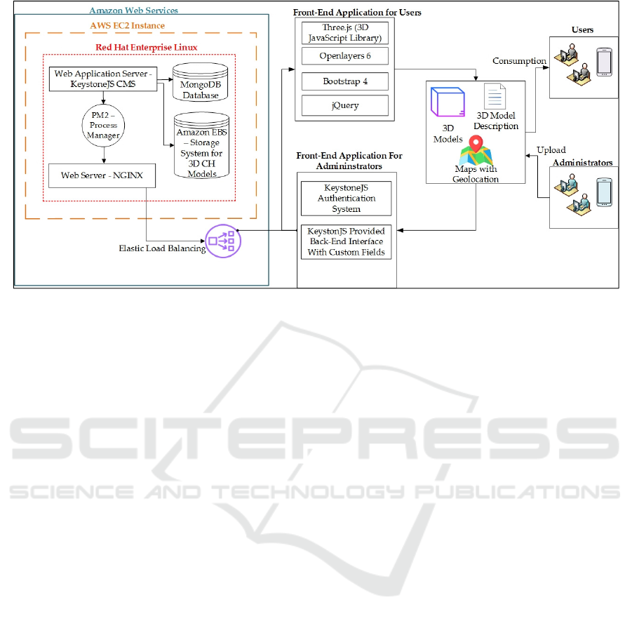
Figure 1: A methodology for the proposed cloud architecture for processing and visualization of 3D digital cultural heritage
models.
4 METHODOLOGY
To accomplish the proposed cloud architecture, a
methodology as shown in Figure 1 has been
developed. The web application server KeystoneJS
CMS and front-end application in the methodology
are based on the previous research work of the author.
The methodology presented in the article extends
those parts with cloud computing concepts such as
Amazon EC2 Instance, Amazon EBS storage for 3D
CH models, Elastic Load Balancing, PM2 process
manager, the web server of NGINX, cloud installed
MongoDB database among others. This extended
methodology consists of the followings:
Cloud computing infrastructure from AWS
including Amazon Elastic Compute Cloud (AWS
EC2), Red Hat Enterprise Linux as an operating
system, Web Application Server – Keystone JS CMS,
MongoDB database, Amazon Elastic Block Store
(Amazon EBS), PM2 - Process Manager, Web Server
– NGINX, and Elastic Load Balancing.
Front-end application for administrators which
includes the KeystoneJS authentication system and
KeystoneJS provided back-end interface with custom
fields.
Front-end application for users which includes
Three.js – WebGL-based 3D JavaScript library,
Openlayers 6 – web mapping library, Bootstrap 4 for
the graphical user interface, and jQuery
Datasets including maps, Australian 3D CH
models, 3D model descriptions and geospatial data in
the form of geolocation such as longitude and
latitude.
Finally, users and administrators, who consume
the data and manage the data respectively.
4.1 Cloud Computing
AWS has been selected as a cloud computing
solutions provider as it is dominant and the largest
provider in the cloud computing market.
Furthermore, it offers a variety of services and virtual
machines for various purposes such as from hosting a
small website to Big Data analytics. In the
architecture, EC2 has been deployed to get the cloud
computing capacity and launch the virtual server. As
an operating system of the EC2, Red Hat Enterprise
Linux has been deployed which is a Linux
distribution developed by Red Hat for the commercial
market. This operating system was chosen because it
is one of the leading Linux kernels with high security,
reliability, and good community support. The web
application server in this architecture is KeystoneJS
CMS, which is based on Express.js framework and
Node.js runtime environment. Since KeystoneJS is a
database-driven CMS, it comes with a MongoDB
database by default. This database has been utilized
to store all the data within the architecture except for
3D CH models. The storage of 3D models has been
facilitated by Amazon Elastic Block Store (EBS),
which is a high-performance storage service to use
with Amazon EC2. Another important feature of this
storage is the possibility to enable the automated
A Cloud Architecture for Processing and Visualization of Geo-located 3D Digital Cultural Heritage Models
55
capability to back up the data into Amazon S3.
NGINX has been used as a web server in the
architecture, whereas PM2 Process Manger used to
manage and monitor the web application of
KeystoneJS. Finally, Elastic Load Balancing is used
to automatically distribute incoming traffic to the web
application, which helps to improve the
responsiveness of the web application.
4.2 Front-end Application for
Administrators
Front-end application for administrators has been
accomplished with the auto-generated admin user
interface by the KeystoneJS. It also handles the
authentication system for administrators out of the
box. KeystoneJS allows creating as many
administrators as needed. However, one limitation of
KeystoneJS in this regard is it does not provide a
feature to assign roles to the administrators, which
can grant or restrict access to certain fields and
documents within the admin interface. Text data in
the administrator interface is inputted via
WYSIWYG (what you see is what you get) editor,
while files such as 3D CH models are uploaded via
the built-in file upload interface. For the uploaded
content, there are three states available namely draft,
published, and archived.
4.3 Front-end Application for Users
Front-end application for users was achieved using
Three.js, Openlayers 6, Bootstrap 4 and jQuery.
Three.js is a cross-browser 3D JavaScript library
based on previously mentioned WebGL technology,
which facilitated 3D visualization in the architecture.
It offers numerous features to build simple and
complex 3D scenes and worlds. This 3D library has
been chosen because of its non-proprietary license,
integration with all web browsers that support
WebGL, and relatively well-documentation among
others. Openlayers 6 is used for web mapping in the
architecture, which can visualize maps including
geospatial data such as vector data and raster data in
different geospatial files from various sources and
geospatial web mapping standards of Open
Geospatial Consortium (OGC). Since Openlayers is
an open-source, mature, web mapping library with a
strong community of developers, it has been selected
for map and web geospatial data visualization.
Bootstrap 4 framework is used as a helper framework
for graphical user interface implementation. It is the
world’s most popular framework for building the
front-end development of web applications, which is
also known for its responsive and mobile-first
concepts. Since Bootstrap focuses on simplifying the
development of front-end web applications, it offers
several ready-to-use templates and components such
as navigation, forms, and typography. Finally, the
jQuery framework is a JavaScript library for
simplification of HTML DOM manipulation, event
handling, and asynchronous calls. As of writing this
article, it is employed by 74% of the 10 million most
popular websites (W3Techs).
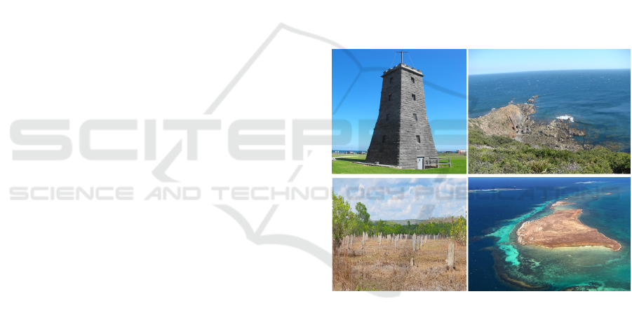
4.4 Datasets
As a use case, eleven different 3D digital CH models
have been deployed to the architecture. All deployed
3D models are digital replicas of the places located in
Australia. As a sample, four of these 3D models are
presented in the article namely Time Ball Tower-
Williamstown, Cape Liptrap, Magnetic Termite and a
part of the Abrolhos Islands. The images of these
places are shown
in Figure 2.
Figure 2: Sample of the employed 3D digital models in the
use case. In a clockwise direction, Time Ball Tower,
Williamstown (Image Source: https://bit.ly/2FfKuuT,
Copyright by Nick Morieson. CC BY-SA 2.0), Cape
Liptrap (Image Source: https://bit.ly/2MTdNrr, Copyright
by Jorge Lascar. CC BY 2.0), Magnetic Termite (Image
Source: https://bit.ly/2ZO5an6, Copyright by Geoff
Whalan. CC BY-NC-ND 2.0), Abrolhos Islands (Image
source: https://bit.ly/37qOPaG, Copyright by
ernie_greatoutdoors. CC BY-SA 2.0).
One of the best choices with regard to 3D file
formats is glTF as it significantly minimizes the size
and loading times of 3D models in comparison to
other 3D file formats. Hence, all 3D models in the use
case are encoded in glTF format. Furthermore, the
architecture has also been tested with another 3D file
format called “OBJ”. This format is an open format
GISTAM 2020 - 6th International Conference on Geographical Information Systems Theory, Applications and Management
56
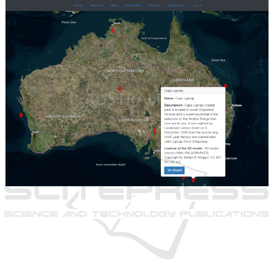
Figure 3: The web interface for users, the map copyright by Microsoft Bing Maps 2019.
by Wavefront technologies, which incorporates three
files. The first file is for storing a 3D object-related
information such as vertices, faces, and has an
extension of “.obj”. Whereas, the second file is a
material template library with an extension of “.mtl”,
which stores the appearance of the 3D model. Finally,
the last file is for storing associated images with the
3D model, which can include more than a single
image file. The file extensions for the images can be
in “.jpeg”, “.png” among others. The path link for all
images is stored in the previously discussed “.mtl”
file.
4.5 Users and Administrators
Users of this cloud-based architecture platform can
view a map, interact with vector data in the form of
point features which represent CH places, read
descriptions of CH places, and view 3D CH models.
Whereas, administrators can create and edit CH
places, upload 3D content to the platform, input
geospatial data such as geolocation associated with
CH places, select and change the state of the content
among others.
5 RESULTS AND DISCUSSIONS
The cloud architecture integrates web maps, 3D
digital CH models and geospatial information
associated with the 3D CH models in the form of
geolocation, while also offering numerous cloud
architecture benefits such as improved application
performance, scalability, and enhanced
responsiveness.
The overall web interface for users consists of
three main components namely base map, clickable
red markers which represent CH places with relevant
CH information, and viewer for visualization of 3D
CH models. This user interface is shown in Figure 3.
Once a user clicks on a red marker, the pop-up box
appears with the information relating to the CH place
such as name, short description, and licence
information of the 3D model. To view the 3D model,
they should click onto the 3D model button in the
pop-up box.
A Cloud Architecture for Processing and Visualization of Geo-located 3D Digital Cultural Heritage Models
57
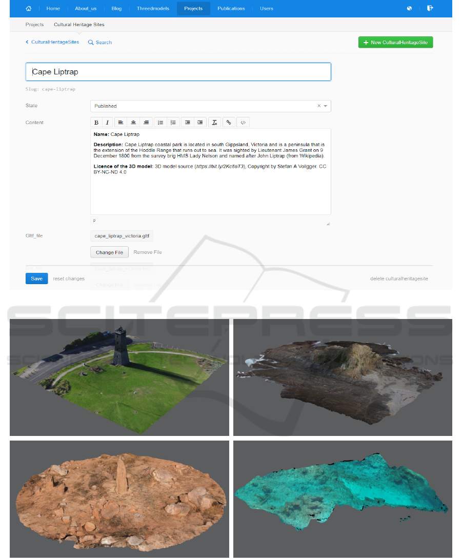
Figure 4: The web interface for administrators, copyright by KeystoneJS, MIT licence 2019.
Figure 5: Use case of Australian 3D cultural heritage models. In a clockwise direction, Time Ball Tower, Williamstown (3D
Model Source: https://bit.ly/2ZJR3PZ, Copyright by Digital Heritage Australia. CC BY 4.0), Cape Liptrap (3D Model Source:
https://bit.ly/2QFMwtI, Copyright by Stefan A Vollgger. CC BY-NC-ND 4.0 ), Magnetic Termite (3D Model Source:
https://bit.ly/2syNqjO, Copyright by Rupert Rawnsley. CC BY 4.0), Abrolhos Islands (3D Model Source:
https://bit.ly/2syY9e3, Copyright by Maritime Archeological Association of Western Australia. CC BY 4.0).
GISTAM 2020 - 6th International Conference on Geographical Information Systems Theory, Applications and Management
58

In KeystoneJS CMS there is no limitation on the
number of administrators. Hence, it allows creating as
many administrators as needed. A page relating to
creating a new CH place and uploading 3D content to
the architecture is shown in Figure 4. When creating
a new CH place, administrators should input the name
of the CH place, description including short
information and licence information of the CH place,
and 3D digital CH model to upload. 3D digital CH
models are automatically uploaded into Amazon EBS
storage and path to the 3D content is stored in the
MongoDB database.
This path is then used in the front-end application to
retrieve the 3D CH model. The administrators can
also select the state of the CH place from 3 options
namely draft, published, archived. These states can
help to manage the process of publication. For
instance, they may upload the content but wish to
publish it later in time. Finally, for each and every CH
place administrators should input geolocation in the
form of longitude and latitude. The precise
geolocation for the most CH places can be found in
the GeoNames platform, which is a geographical
database with more than 11 million place names.
5.1 Use Case of Australian 3D Digital
Cultural Heritage Models
The architecture has been employed in a sample use
case to better evaluate its benefits and limitations. As
mentioned in the datasets section, eleven different
3D digital CH models have been used in this use case.
The visualization of four of these 3D CH models is
shown in Figure 5, which is achieved using the
Three.js 3D visualization library. The 3D models can
be manipulated along the X, Y and Z coordinate axes,
and can be zoomed in and out.
5.2 Level of Customization for the
Front-end 3D Visualization
As mentioned previously, in this architecture 3D
visualization is achieved using the Three.js library,
which offers plenty of customizations. These
customizations include importing and removing
complimentary 3D models at run-time, various
cameras such as orthographic, perspective and stereo
cameras, various audio types such as positional and
non-positional, various lights such as point,
directional, and spot-lights, and three levels of details
(LOD) among others. These customizations can take
effect at run-time as Three.js is capable of updating
scenes continuously.
5.3 Scalability of the Architecture
The proposed architecture is based on AWS, which
offers many features for scalability, load balancing,
etc. The architecture particularly uses Elastic Load
Balancing to automatically distribute incoming
traffic. This offers an on-demand scale-up, in other
words, the ability to increase the number of EC2
instances running the web application when there is a
high load of incoming traffic. Whereas KeystoneJS
CMS handles internal tasks within the web
application. Since KeystoneJS CMS is based on the
Node.js runtime environment, it supports an event-
driven system capable of running asynchronous input
and output. In other words, it can run several
processes separately from the primary application
thread. Therefore, this offers numerous benefits such
as improved application performance, scalability, and
enhanced responsiveness.
6 CONCLUSIONS
With the rapid evolution in digitization technology,
CH professionals are now equipped with advanced
3D surveying tools and techniques. This allows them
to create a realistic 3D digital replica of CH sites and
objects of various sizes including tiny artefacts and
large-scale CH establishments. Nevertheless, 3D CH
models are still difficult to find, use and reuse,
especially those which resulted from the individual
CH research projects. According to the survey
findings of Champion and Rahaman (2019), who
looked at 1483 digital heritage articles published in
14 recent proceedings of major CH conferences, from
the examined 1483 conference articles, only 9 articles
had accessible links to 3D assets.
This article presented a new cloud-based
architecture for integrating maps, 3D digital CH
models and geospatial data, which can be used for
processing, visualization, dissemination and digital
preservation of 3D digital models.
All frameworks used in the architecture such as
for content management, web mapping, 3D
visualization, etc. are based on free and open-source
paradigm, which allows flexibility on extensions and
re-use. For instance, raster and vector data can be
integrated into the architecture by implementing a
free and open-source geospatial framework of
GeoServer, which allows publishing geospatial data
to the web using open standards such as from OGC.
Furthermore, among others, on top of this architecture
geospatial analyses on the web can be performed
A Cloud Architecture for Processing and Visualization of Geo-located 3D Digital Cultural Heritage Models
59

using Turf.js, web virtual reality can be implemented
using React 360.
The proposed architecture has been validated
through a use-case applied to Australian 3D CH
models.
REFERENCES
Ali, M., Khan, S. U., & Vasilakos, A. V. (2015). Security
in cloud computing: Opportunities and challenges.
Information sciences, 305, 357-383.
Amazon-EC2. Amazon EC2 homepage. https://
aws.amazon.com/ec2/ (Accessed 28 November 2019)
Apollonio, F. I., Rizzo, F., Bertacchi, S., Dall’Osso, G.,
Corbelli, A., & Grana, C. (2017). SACHER: smart
architecture for cultural heritage in Emilia Romagna.
Paper presented at the Italian Research Conference on
Digital Libraries.
Ariadne-Infrastructure-Project. Ariadne Infrastructure
project homepage. https://ariadne-infrastructure.eu/
(Accessed 28 November 2019)
Benardou, A., Dallas, C., & Dunning, A. (2014). From
Europeana Cloud to Europeana Research: The
challenges of a community-driven platform exploiting
Europeana content. Paper presented at the Euro-
Mediterranean Conference.
Bertacchi, S., Jawarneh, A., Mashhour, I., Apollonio, F. I.,
Bertacchi, G., Cancilla, M., . . . Montanari, R. (2018).
SACHER Project: A Cloud Platform and Integrated
Services for Cultural Heritage and for Restoration.
Paper presented at the Proceedings of the 4th EAI
International Conference on Smart Objects and
Technologies for Social Good.
Bharadwaj, S. S., & Lal, P. (2012). Exploring the impact of
Cloud Computing adoption on organizational
flexibility: A client perspective. Paper presented at the
2012 International Conference on Cloud Computing
Technologies, Applications and Management
(ICCCTAM).
Campanaro, D. M., Landeschi, G., Dell’unto, N., &
Leander Touati, A.-M. (2016). 3D GIS for cultural
heritage restoration: A ‘white box’ workflow. Journal
of Cultural Heritage, 18, 321-332. doi:10.1016/
j.culher.2015.09.006
Champion, E., & Rahaman, H. (2019). 3D Digital Heritage
Models as Sustainable Scholarly Resources.
Sustainability, 11(8), 2425.
Chandra, D. G., & Borah, M. D. (2012). Cost benefit
analysis of cloud computing in education. Paper
presented at the 2012 International Conference on
Computing, Communication and Applications.
D'Andrea, A., Niccolucci, F., Bassett, S., & Fernie, K.
(2012). 3D-ICONS: World Heritage sites for
Europeana: Making complex 3D models available to
everyone. Paper presented at the 2012 18th
International Conference on Virtual Systems and
Multimedia.
De Assunção, M. D., Di Costanzo, A., & Buyya, R. (2009).
Evaluating the cost-benefit of using cloud computing to
extend the capacity of clusters. Paper presented at the
Proceedings of the 18th ACM international symposium
on High performance distributed computing.
DigitalOcean. DigitalOcean homepage. https://www.
digitalocean.com/ (Accessed
E-RIHS-Project. E-RIHS project homepage. 28 November
2019)
EUDAT. EUDAT-Cloud-like-services-to-improve-the-
preservation-of-digital-cultural-heritage.
https://eudat.eu/communities/cloud-like-services-to-
improve-the-preservation-of-digital-cultural-heritage
(Accessed 28 November 2019)
EUDAT. EUDAT project homepage. 28 November 2019)
Falatah, M. M., & Batarfi, O. A. (2014). Cloud scalability
considerations. International Journal of Computer
Science and Engineering Survey, 5(4), 37.
Fanini, B., Pescarin, S., & Palombini, A. (2019). A cloud-
based architecture for processing and dissemination of
3D landscapes online. Digital Applications in
Archaeology and Cultural Heritage, e00100.
Google-Compute-Engine. Google Compute Engine
homepage. https://cloud.google.com/compute/
(Accessed 28 November 2019)
Heroku. Heroku homepage. https://www.heroku.com/
(Accessed 28 November 2019)
Horsman, G. (2018). Web Content Management Systems:
An Analysis of Forensic Investigatory Challenges.
Journal of Forensic Sciences, 63(5), 1392-1400.
doi:10.1111/1556-4029.13763
Kats, P., Mielnicki, M., Knoth, P., Muhr, M., Mamakis, G.,
& Werla, M. (2014). Design of Europeana Cloud
technical infrastructure. Paper presented at the
IEEE/ACM Joint Conference on Digital Libraries.
Lee, J. Y., & Kim, S. D. (2010). Software approaches to
assuring high scalability in cloud computing. Paper
presented at the 2010 IEEE 7th International
Conference on E-Business Engineering.
McKeever, S. (2003). Understanding Web content
management systems: evolution, lifecycle and market.
Industrial management & data systems, 103(9), 686-
692.
ownCloud. ownCloud project homepage. 28 November
2019)
Pisu, C., & Casu, P. (2013). Cloud GIS and 3d modelling to
enhance sardinian late gothic architectural heritage.
International Archives of the Photogrammetry, Remote
Sensing and Spatial Information Sciences, 5, W2.
Remondino, F. (2011). 3D recording for cultural heritage.
Paper presented at the Remote Sensing for
Archaeological Heritage Management, EAC
Symposium.
Sacher-Project. Sacher project homepage. http://www.
eng.sacherproject.com/ (Accessed 28 November 2019)
Salesforce. Salesforce homepage. https://www.
salesforce.com/ (Accessed 28 November 2019)
Singh, A., & Malhotra, M. (2012). Agent based framework
for scalability in cloud computing. International
GISTAM 2020 - 6th International Conference on Geographical Information Systems Theory, Applications and Management
60

Journal of Computer Science & Engineering
Technology (IJCSET), 3(4), 41-45.
Sultan, N. (2014). Making use of cloud computing for
healthcare provision: Opportunities and challenges.
International Journal of Information Management,
34(2), 177-184.
Virtual-Planet-Builder. Virtual Planet Builder project
homepage. 28 November 2019)
W3Techs. W3Techs - Usage of JavaScript libraries for
websites website. 28 November 2019)
WebGL. WebGL project homepage. https://www.
khronos.org/webgl/ (Accessed 28 November 2019)
Zafar, F., Khan, A., Malik, S. U. R., Ahmed, M., Anjum,
A., Khan, M. I., . . . Jamil, F. (2017). A survey of cloud
computing data integrity schemes: Design challenges,
taxonomy and future trends. Computers & Security, 65,
29-49.
Zhang, Q., Cheng, L., & Boutaba, R. (2010). Cloud
computing: state-of-the-art and research challenges.
Journal of Internet Services and Applications, 1(1), 7-
18. doi:10.1007/s13174-010-0007-6.
A Cloud Architecture for Processing and Visualization of Geo-located 3D Digital Cultural Heritage Models
61
