
Machine Learning to Geographically Enrich Understudied Sources:
A Conceptual Approach
Lorella Viola
1a
and Jaap Verheul
2b
1
Luxembourg Centre for Contemporary and Digital History (C
2
DH), University of Luxembourg, Belval Campus,
Maison des Sciences Humaines, 11, Porte des Sciences, L-4366 Esch-sur-Alzette, Luxembourg
2
Department of History and Art History, Utrecht University, Drift 6, 3512 BS, Utrecht, The Netherlands
Keywords: Machine Learning, Sequence Tagging, Spatial Humanities, Geographical Enrichment, Immigrant
Newspapers.
Abstract: This paper discusses the added value of applying machine learning (ML) to contextually enrich digital col-
lections. In this study, we employed ML as a method to geographically enrich historical datasets. Specifically,
we used a sequence tagging tool (Riedl and Padó 2018) which implements TensorFlow to perform NER on a
corpus of historical immigrant newspapers. Afterwards, the entities were extracted and geocoded. The aim
was to prepare large quantities of unstructured data for a conceptual historical analysis of geographical refer-
ences. The intention was to develop a method that would assist researchers working in spatial humanities, a
recently emerged interdisciplinary field focused on geographic and conceptual space. Here we describe the
ML methodology and the geocoding phase of the project, focussing on the advantages and challenges of this
approach, particularly for humanities scholars. We also argue that, by choosing to use largely neglected
sources such as immigrant newspapers (also known as ethnic newspapers), this study contributes to the debate
about diversity representation and archival biases in digital practices.
1 INTRODUCTION
Advances in machine learning (ML) are allowing re-
searchers both in computer science and the humani-
ties to develop new tools and methods for exploring
digital collections. At the same time, libraries are re-
sorting more and more to ML methods to maximise
the potential of their collections, to improve the user
experience, and to discover the technical require-
ments necessary to facilitate the discovery and use of
digital collections. One effective application of ML is
enriching digital data with geographical information.
Because ML uses contextual information to disam-
biguate entities, the method goes beyond the state of
the art of place name extraction and disambiguation
based on gazetteers or ensembles of NER-tools
(Canale, Lisena, and Troncy 2018; Won, Murrieta-
Flores, and Martins 2018; Mariona Coll Ardanuy and
Sporleder 2017; Maria Coll Ardanuy 2017).
This article discusses the added value as well as
the challenges of using a ML method aimed to subse-
a
https://orcid.org/0000-0001-9994-0841
b
https://orcid.org/0000-0001-6978-7698
quently perform conceptual Named Entity Recogni-
tion (cNER), a way to identify subjective and situa-
tional geographical markers and connect them to ex-
plicit geo-references to space. In doing so, cNER
aligns with what has been referred to as Spatial Turns,
a revision of past approaches to the study of space and
place (Murrieta-Flores & Martins, 2019) which
acknowledges that place and space are distinct enti-
ties as place is created through social experiences and
can be both real and imagined.
As its evidence, the study uses a corpus of Italian
American historical newspapers (ChroniclItaly, Vi-
ola 2018) published between 1898 and 1920. We ar-
gue that cNER opens up a way to explore the cultural
context of geographical place and that, by choosing to
use a largely neglected data source such as immigrant
newspapers, on the whole this study contributes to the
debate about language diversity representation and
archival biases in digital practices.
Viola, L. and Verheul, J.
Machine Learning to Geographically Enrich Understudied Sources: A Conceptual Approach.
DOI: 10.5220/0009094204690475
In Proceedings of the 12th International Conference on Agents and Artificial Intelligence (ICAART 2020) - Volume 1, pages 469-475
ISBN: 978-989-758-395-7; ISSN: 2184-433X
Copyright
c
2022 by SCITEPRESS – Science and Technology Publications, Lda. All rights reserved
469

2 CONTEXT OF THE STUDY
The study stands at the crossroads of migration stud-
ies, linguistics, history, and digital humanities. It de-
veloped within the context of a larger project, the
GeoNewsMiner (GNM - Viola et al., 2019) aiming to
create a visualisation tool of geo-references. The tool
was intended to assist researchers working in spatial
humanities, a recently emerged interdisciplinary field
focussing on geographic and conceptual space, espe-
cially from a historical perspective (Bodenhamer,
Corrigan, & Harris, 2010, 2015a). Essentially, spatial
humanities are based on Geographic Information Sys-
tems (GIS). GIS are used to geo-reference a dataset,
map it, display it, and analyse it by cross-referencing
different layers of information. Such process of cross-
referencing has provided researchers working in
fields such as environmental history, historical de-
mography, and economic, urban and medieval history
with new perspectives leading them to challenge tra-
ditional positions and even explore new questions.
One of the conceptual challenges digital humani-
ties is engaging with as it evolves out of GIS map-
ping, is to identify the layers of meaning humans at-
tached historically to geographical spaces. Only when
humans invest meaning in such landscapes, locales
and dwellings, the objective space is turned into a
“place” that they can be emotionally attached to, and
that can be part of collective narratives of pride, long-
ing or loss. Whereas geographical space is “a realm
without meaning […] a ‘fact of life’, which, like time,
produces the basic coordinates for human life,” the
concept of place is space in which humans have in-
vested meaning (Cresswell, 2010, p. 10; Gregory,
2014; Withers, 2009). One of the central aims of spa-
tial humanities has become to connect these cultural
constructs to an Euclidian grid of space, for instance
by performing “deep mapping” (Bodenhamer, Corri-
gan, & Harris, 2015b, pp. 26–28, passim).
Importantly, the subjective attachment to place is
expressed in the way such locations places are given
proper names. Whereas GIS codes represent digital
definitions of geographical space, toponyms or place
names are often much more ambiguous cultural mark-
ers that represent attachment, fear, longing or other
sentiments. Spatial humanities has begun to connect
these subjective connotations to the toponyms that
can be extracted as named entities from digitized
texts, such as travel narratives, novels and newspa-
pers (Donaldson, Gregory, & Taylor, 2017; Tally,
2011; Taylor, Donaldson, Gregory, & Butler, 2018).
Although much work has been done in the field of
geographic text analysis (GTA), one of the next chal-
lenges within spatial humanities that this article ad-
dresses is how such geographical markers change
over time as a result of human movement and migra-
tion (White, 2010, pp. 17, 18, passim). Here we at-
tempt to tackle questions concerning the way places
are mentioned by migrants, individuals who are dis-
placed and have to make sense of their lives across
contesting cultural values and traditions. The chal-
lenge is to trace how toponyms serve as diasporic id-
iotopes that migrants use to negotiate the attachment
to their lost homeland and the new host society. We
argue that spatial humanities can help to extract such
indicators of a sense of place in large heritage collec-
tions and map the “persistence of place in a hectic
world” (Pascual-de-Sans, 2004).
Drawing from the application of ML, GIS, data
mining, and visualisation, the paper discusses how
performing cNER on ethnic newspapers can provide
researchers with new perspectives on the geographies
of the past so as to open up new ways to study the
socio-cognitive dimension of migration history.
3 THE TASK OF NER
In order to conceptualise the historicization of place
name disambiguation, a method is needed to identify
toponymic identifiers in big data collections within
their proper historical context (such as place names,
borders, and nations). Current Named Entity Recog-
nizers (such as the much-used Stanford Named Entity
Tagger) assume rigid designators and are historically
static, as often based on contemporary word lists.
This means that they cannot interpret historical
changes in place names (e.g., St. Petersburg - Petro-
grad - Leningrad) within their proper historical con-
text and cannot deal with culturally ambiguous geo-
graphical references (e.g., America, United States, the
New World, Washington) or homonymic identifiers
(e.g., Limerick – limerick) (Marrero et al, 2013;
Neudecker, 2014).
The most common way to overcome these limita-
tions is to train classifiers, employing semi-super-
vised ML, sometimes using crowdsourcing, or to use
hand-crafted grammar-based systems that require in-
tensive supervision by computational linguists. The
required annotation labour prohibits application to
big datasets of historical periodicals and other serial
texts that are currently available (Ju et al., 2016).
An alternative route is to disambiguate entities on
the basis of contextual information sources such as
Wikipedia (Coll Ardanuy, 2017; Coll Ardanuy &
Sporleder, 2017; Zhang & Iria, 2009) or to combine
place name taggers with a scoring system within an
ARTIDIGH 2020 - Special Session on Artificial Intelligence and Digital Heritage: Challenges and Opportunities
470

ensemble (Canale, Lisena, & Troncy, 2018; Won,
Murrieta-Flores, & Martins, 2018). As recent surveys
confirm, however, ML algorithms based on neural
networks now outperform all methods that are based
on gazetteers or static databases (Yadav & Bethard,
2019). These latter methods present two major ad-
vantages in text enriching: 1) they may be based on
the historical context of a historical corpus
(McDonough, Moncla, & van de Camp, 2019); 2)
they are able to recognize toponyms in a dynamic way
as a geographical concept (Eijnatten, 2019). We pro-
pose to use the term conceptual NER (cNER) as a
level of analysis to enrich place name analysis.
4 METHODOLOGY AND
DATASET
To establish and maintain internal cohesion whilst
distinguishing themselves from others, diasporic
groups adopt a collective concept of identity. Such
shared identity is constructed through a variety of
markers which may be religious, linguistic, performa-
tive and of other nature, for example geographical.
This type of diasporic identity markers is conveyed
through language to both express the bond with a ‘re-
membered homeland’ and the connection with the
host society. cNER applies a pragmatic perspective to
the task of NER by assessing the socio-linguistic in-
formation and historical context in which places are
mentioned and discussed. This is done by combining
the visualisation of place name references with lin-
guistic, social, and historical data, both automatically
-for instance by means of sentiment analysis- and
non-automatically, through the qualitative analysis of
sample excerpts. The overarching aim is to visualise
the narratives behind distant and local places and ob-
tain deeper insights of how such links were main-
tained and renegotiated over time for contemporary
purposes and future generations. Here we focus on the
ML (cfr. 4.1) and geocoding parts (cfr. 4.2) of the
study.
4.1 Machine Learning
The collection was first tagged for entities using an
advanced ML sequence tagging tool that implements
Tensorflow (Riedl and Padó, 2018). The novelty of
the tool lies in the fact that it combines BiLSTM and
CRF and character embeddings. The two methods
1
https://developers.google.com/maps/documentation/geoc
oding/start
were tested separately against four datasets to com-
pare both individual performances and the combina-
tion of the two. They found that combining BiLSTM
with a CRF as top layer outperforms CRFs with hand-
coded features consistently when enough data is
available. They concluded that modern RNNs have
much to recommend to researchers working in NER
as they consistently yield the best performance.
Methodologically, they trained the character em-
beddings with pre-trained word embeddings while
training the model itself. They also used character-
and subword based word embeddings computed with
FastText (Bojanowski et al., 2017) which, by retriev-
ing embeddings for unknown words through the in-
corporation of subword information, was found to
significantly alleviate issues with out-of-vocabulary
words.
4.2 Geocoding
Once the tagging task was completed, locations were
geocoded by using the Google API. Geocoding with
Google is a two-stage process that requires Google
Geocoding API
1
. First, Google Geocoding API pro-
vides users with a Place ID for each location. The
Place ID uniquely identifies a place as it is stored in
the Google Places database and on Google Maps. Be-
cause the language of the dataset was Italian, the lan-
guage of the API was set to Italian. It was found that
setting the API language as the language of the data-
set improved the accuracy of the geocoding results.
At the same time, however, this meant that the results
were also returned in Italian. Therefore, in order to
have the results returned in English, only the Place ID
was extracted in this first stage. Once the Place ID
was received, it was possible to use the Google Ge-
ocoding API to perform reverse geocoding, that is to
obtain all the details for the location in English (e.g.,
geo-coordinates, administrative level).
4.3 ChroniclItaly
To demonstrate the potential of cNER, we used a cor-
pus of Italian ethnic newspapers (i.e., ChroniclItaly,
Viola 2018) as an example of diasporic media pub-
lished in the United States between 1898 and 1920.
ChroniclItaly is an open access collection that in-
cludes all front pages of seven Italian language news-
papers published in California, Massachusetts, Penn-
sylvania, Indiana, Vermont, and West Virginia be-
Machine Learning to Geographically Enrich Understudied Sources: A Conceptual Approach
471
tween 1898 and 1920. The corpus, which was ex-
tracted from the Chronicling America newspaper col-
lection of the Library of Congress, includes 4,810 is-
sues and for a total of 16,624,571 words. Featuring
mainstream (prominenti), radical (sovversivi), and
politically independent newspapers, ChroniclItaly is
a well-balanced resource for the study of the Italian
immigrant press of the time. Moreover, because it is
entirely digital, this corpus is a powerful tool for con-
ducting text-based searches and analysis, both quan-
titative and qualitative. The newspapers’ titles are:
L’Italia, Cronaca sovversiva, La libera parola, The
patriot, La ragione, La rassegna, and La sentinella
del West Virginia.
Although immigrant newspapers have often been
used by migration historians also to study questions
of belonging in relation to space, such socio-cognitive
dimension of migration remains largely unexplored
digitally. This includes the lack of use of immigrant
newspapers not only as a source of data analysis but
also as a starting point for creating research and anal-
ysis tools. Thus, by using ChroniclItaly, we also
aimed to contribute to the debate about the lack of di-
versity, archival biases and silences in the archives in
digital scholarship. Thanks to larger amounts of data,
today the digital analysis of place name references in
immigrant storytelling allows researchers to under-
stand how individuals made sense of their diasporic
identities within the host community and perhaps re-
consider previous interpretations.
Finally, it is worth mentioning that digital schol-
ars wishing to carry out research in languages other
than English often find themselves confronted with
the relative lack of appropriate computational re-
sources, including for instance accessing already
available trained models in the desired language.
Thus, by both using and creating resources in Italian,
the study also addresses the issue of underrepresenta-
tion of languages other than English in digital schol-
arship.
5 TAGGING THE CORPUS
The sequence tagging model for the Italian language
was trained on I-CAB (Italian Content Annotation
Bank), an open access corpus annotated for entities
(i.e. persons-PER, organizations-ORG, locations-
LOC, and geopolitical entities-GPE), temporal ex-
pressions, and relations between entities. I-CAB con-
tains 525 news articles taken from the Italian newspa-
2
https://fasttext.cc/docs/en/crawl-vectors.html
per L'Adige and totals up around 180,000 words. Em-
beddings were computed using Italian Wikipedia and
they have been trained using Fastext with 300 dimen-
sions
2
. Once the training was complete, the output had
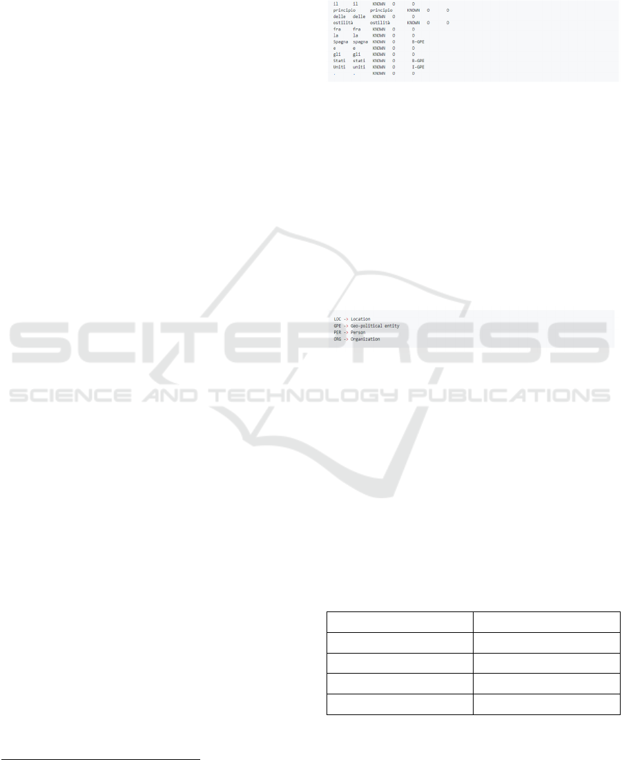
the following format (Figure 1):
Figure 1: Output of the sequence tagger for ChroniclItaly.
The first column is the input word, the second column
specifies the pre-processed, lowercased word, the
third column contains a flag, that is whether the word
has been known during training (KNOWN) or not
(UNKNOWN). If labels are assigned to the input file,
these will appear in the third column. The last column
contains the predicted tags. The no-entity tag is O.
Because some entities (e.g., Stati Uniti "United
States") have multiple words, the tagging scheme dis-
tinguishes between the beginning (tag B-...) or the in-
side of an entity (tag I-...). Figure 2 shows the tags:
Figure 2: Tags of the sequence tagger.
6 ML RESULTS
The sequence tagger retrieved 1,369 unique locations
(both LOC and GPE) which occurred 214,110 times
throughout the whole corpus. Because each individ-
ual document was time stamped, the number of refer-
ences to each location was quantified at any given
time within the timeframe of ChroniclItaly (i.e.,
1898-1920). The results of the F1 score for Italian
models are shown in Table 1:
Table 1: F1 score for Italian models.
Type Score
accuracy 98.15%
precision 83.64%
recall 82.14%
FB1 82.88
ARTIDIGH 2020 - Special Session on Artificial Intelligence and Digital Heritage: Challenges and Opportunities
472

Table 2 shows the F1 score for each of the entity:
Table 2: F1 score for Italian models per entity.
Entity Precision Recall FB1
GPE 83.90% 86.18% 85.02
LOC 69.70%% 44.23% 54.12
ORG 73.36% 73.08% 73.22
PER 89.78% 87.59% 88.68
The tagged version of ChroniclItaly is ChroniclItaly
2.0 (Viola, 2019) and it is available as an open access
resource
3
.
7 VISUALISATION
To visualise the results, we chose to use a Shiny
4
app,
the GeoNewsMiner (GNM, Viola et al 2019). This al-
lowed us to present and analyse the data in an intui-
tive, interactive, and reproduceable way. Within
GNM, references to place names in Chroniclitaly can
be explored according to five different levels of ag-
gregations:
Time: from 1898 to 1920;
Newspaper’s title
Type of frequency visualization: absolute,
percentage
Geographical information: include/exclude
references to cities/regions
Percentile: select the least/most mentioned
places
In order to reflect the changing geo-political borders
within the analysed period (1898-1920), users can ad-
ditionally choose between three historical world maps
displaying the different borders at three crucial points
in history which intersect with the timeframe of
ChroniclItaly: 1880, 1914, 1920. By default, GNM
displays a contemporary (1994) world map. Finally,
users can also share their results, download the raw
data which may reflect their filters’ selection, and
download the visualised map as a .png file. GNM is
available as an open access resource,
5
a full documen-
tation of the project is also available on GitHub
6
. Fig-
ure 3 shows a static image of the GNM app.
3
https://doi.org/10.24416/UU01-4MECRO
4
https://shiny.rstudio.com/
Figure 3: Static image of the GNM app.
8 DISCUSSION
The method presented a number of technical chal-
lenges. The first remark concerns the performance of
the sequence tagger. Although the overall F1 score
was satisfactory, the performance for the entity LOC
was rather poor. However, in ChroniclItaly GPE en-
tities significantly outnumbered LOC entities (77.2%
GPE vs 22.8% LOC), thus at least partially compen-
sating for this limitation.
This first issue can be attributed to the second
challenge of the study, namely OCR issues. The
newspapers in ChroniclItaly were digitized primarily
from microfilm holdings. In addition to the well-
known limitations for OCR processes such as unusual
text styles or very small fonts, other limitations occur
when dealing with old material, including markings
on the pages or a general poor condition of the origi-
nal text. Such limitations also apply to the OCR-gen-
erated searchable texts in ChroniclItaly which there-
fore contain errors. However, the OCR quality was
found better in the most recent texts, perhaps due to a
better conservation status or better initial condition of
the originals which overall improved over the course
of the nineteenth century. Therefore, the quality of the
OCR data can vary greatly even within the same
newspaper. The OCR error limitation could however
be at least partially overcome in two ways: first, it was
reasonable to assume that important concept words
would have been repeated several times within an ar-
ticle thus increasing the likelihood that OCR read
them correctly in at least some of the passages. Sec-
ond, the geo-coding was restricted to place names that
were referred to at least more than 8 times across the
whole collection as the highest number of false posi-
tives was found for occurrences <8.
Other minor issues mainly concerned multi-name
locations (e.g., Costa del Pacifico ‘Pacific Coast’)
5
https://utrecht-university.shinyapps.io/GeoNewsMiner/
6
https://github.com/lorellav/GeoNewsMiner
Machine Learning to Geographically Enrich Understudied Sources: A Conceptual Approach
473
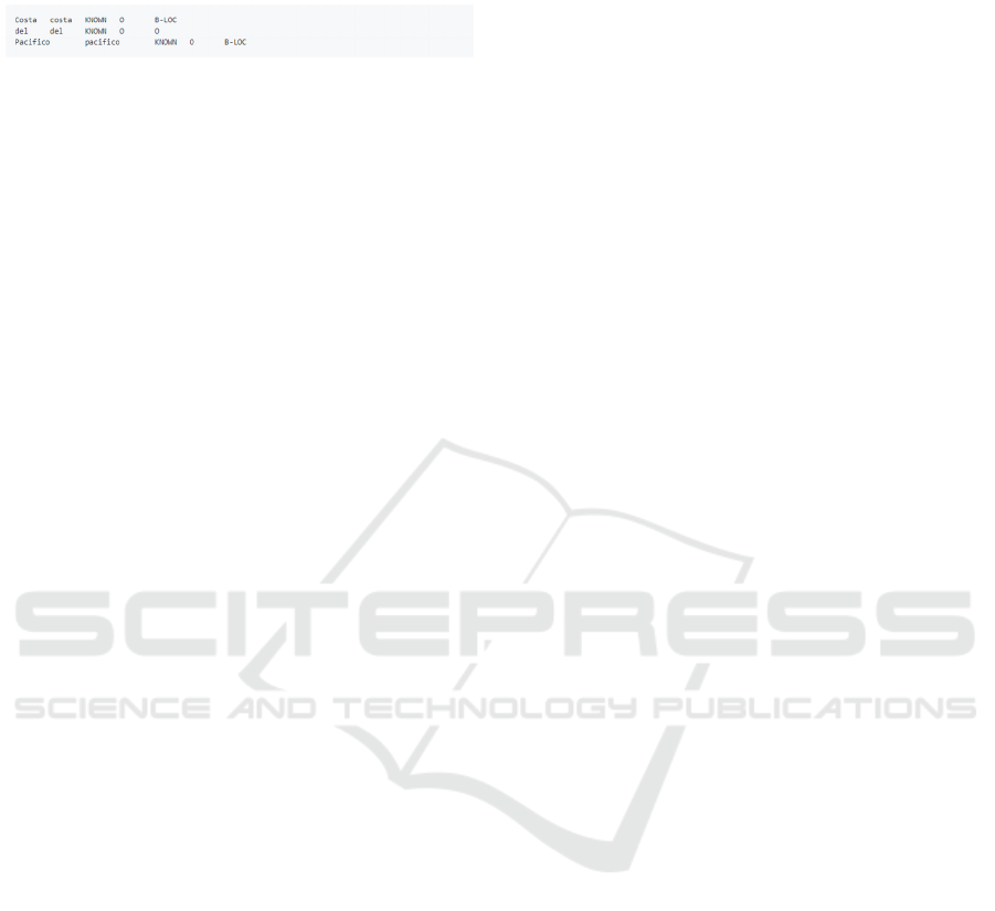
which were tagged as individual parts, as shown in
Figure 4:
Figure 4: Example of tags of the sequence tagger for multi-
name locations.
The third challenge concerned the geocoding phase.
In addition to the geo-coordinates, Google provides
further details, such as the tag type[] indicating why
those specific geo-coordinates have been attributed to
a location. Understanding the type[] of a location is
therefore very important, especially when working
with historical data. The Google Places database
stores places based on a contemporary world map,
however the locations in a historical dataset may have
changed name or may no longer exist. Moreover, cat-
egories such as country, city, region, municipality,
etc. which Google uses to determine the location
type[] are highly dependent on the location itself and
consequently, certain categories may not apply or
they may change from country to country. In ge-
ocoding the places in ChroniclItaly 2.0, we encoun-
tered cases in which the type and level given by
Google required a manual edit. The full list of re-
marks and manual edits is available in the GNM
GitHub repository.
Despite the described challenges, we argue in fa-
vour of ML methods to enrich digital collections. One
of the biggest advantages of using ML for tagging, for
instance, is that it is not based on gazetteers, therefore
place name extraction and disambiguation is more re-
liable. Another advantage is that models can be con-
tinuously improved by increasing the amount and
quality of data the algorithms learn from, so that they
can make faster and more accurate predictions. Fi-
nally, ML methods offer the huge benefit of being
completely unsupervised thus bearing great potential
of assistance also for not highly computationally
trained researchers, such as humanities scholars. Be-
cause a solid training in ML was not necessary for us-
ing the sequence tagger, indeed, we found that the
most challenging part of the project was the ge-
ocoding phase. Therefore, ML bears great potential
for the humanities: with modest investment of time, it
may be possible to enrich automatically large
amounts of data, saving scholars precious time and
resources that can be dedicated to investigating new
avenues of data analysis.
9 CONCLUSIONS
This paper discussed the added value of applying ML
to contextually enrich digital collections. In this
study, we employed ML as a method to geograph-
ically enrich a historical dataset. Specifically, we used
a deep learning architecture for NER tasks (Riedl and
Padó 2018) which implements TensorFlow to per-
form NER on a corpus of historical immigrant news-
papers (ChroniclItaly, Viola 2018). The aim was to
prepare large quantities of unstructured data for a
conceptual historical analysis of geographical refer-
ences, which we called conceptual Named Entity
Recognition, cNER. Triangulating the quantitative
information provided by ML with data visualisation
and a qualitative (i.e., sentiment), socio-historical and
linguistic analysis, cNER enables us to trace and un-
derstand the changing cultural constructions that are
attached to place names, as they are derived from the
historical context. This further pragmatic level of
analysis will help us to establish how imagined
“place” is defined over time in relation to changing
realities of space. We argue that overall the cNER
method does better justice to the historical ambigui-
ties that are embedded in the texts themselves than
extraction on the basis of gazetteers or static external
information allow us to achieve.
Despite a number of limitations which were
mainly encountered during the geocoding phase, we
found that the method has much to recommend par-
ticularly to humanities scholars who are more and
more confronted with the challenge of exploring col-
lections larger than before and in a digital format. Fi-
nally, we also argued that, by choosing to use largely
neglected sources such as Italian immigrant newspa-
pers, this study contributed to the debate about lan-
guage diversity representation and archival biases in
digital practices.
REFERENCES
Ardanuy, Maria Coll. (2017). Entity-Centric Text Mining
for Historical Documents. Georg-August-Universitat
Gottingen, Göttingen.
Ardanuy, Mariona Coll, & Sporleder, C. (2017). Toponym
disambiguation in historical documents using semantic
and geographic features. Proceedings of the 2nd Inter-
national Conference on Digital Access to Textual Cul-
tural Heritage - DATeCH2017, 175–180. https://
doi.org/10.1145/3078081.3078099
Bodenhamer, D. J., Corrigan, J., & Harris, T. M. (Eds.).
(2010). The spatial humanities: GIS and the future of
humanities scholarship. Bloomington, Ind.: Indiana
Univ. Press.
ARTIDIGH 2020 - Special Session on Artificial Intelligence and Digital Heritage: Challenges and Opportunities
474

Bodenhamer, D. J., Corrigan, J., & Harris, T. M. (Eds.).
(2015a). Deep maps and spatial narratives. Blooming-
ton: Indiana University Press.
Bojanowski, P. Grave, E., Joulin, A. and Mikolov, T. 2017.
Enriching word vectors with subword information.
Transactions of the Association for Computational Lin-
guistics 5:135–146.
Canale, L., Lisena, P., & Troncy, R. (2018). A Novel En-
semble Method for Named Entity Recognition and Dis-
ambiguation Based on Neural Network. In D.
Vrandečić, K. Bontcheva, M. C. Suárez-Figueroa, V.
Presutti, I. Celino, M. Sabou, … E. Simperl (Eds.), The
Semantic Web – ISWC 2018 (Vol. 11136, pp. 91–107).
https://doi.org/10.1007/978-3-030-00671-6_6
Cresswell, T. (2010). Place: A short introduction (Repr.).
Malden, Mass.: Blackwell.
Donaldson, C., Gregory, I. N., & Taylor, J. E. (2017). Lo-
cating the beautiful, picturesque, sublime and majestic:
Spatially analysing the application of aesthetic termi-
nology in descriptions of the English Lake District.
Journal of Historical Geography, 56, 43–60.
https://doi.org/10.1016/j.jhg.2017.01.006
Eijnatten, J. V. (2019). Something about the Weather. Us-
ing Digital Methods to Mine Geographical Conceptions
of Europe in Twentieth-Century Dutch Newspapers.
BMGN - Low Countries Historical Review, 134(1), 28–
61. https://doi.org/10.18352/bmgn-lchr.10655
Gregory, I. N. (2014). Further Reading: From Historical
GIS to Spatial Humanities: An Evolving Literature. In
I. N. Gregory & A. Geddes (Eds.), Toward spatial hu-
manities: Historical GIS and spatial history (pp. 186–
202). Bloomington, Ind.: Indiana Univ. Press.
Ju, Y., Adams, B., Janowicz, K., Hu, Y., Yan, B., &
McKenzie, G. (2016). Things and Strings: Improving
Place Name Disambiguation from Short Texts by Com-
bining Entity Co-Occurrence with Topic Modeling. In
E. Blomqvist, P. Ciancarini, F. Poggi, & F. Vitali
(Eds.), Knowledge Engineering and Knowledge Man-
agement (Vol. 10024, pp. 353–367).
https://doi.org/10.1007/978-3-319-49004-5_23
Marrero, M., Urbano, J., Sánchez-Cuadrado, S., Morato, J.,
& Gómez-Berbís, J. M. (2013). Named Entity Recogni-
tion: Fallacies, challenges and opportunities. Computer
Standards & Interfaces, 35(5), 482–489.
https://doi.org/10.1016/j.csi.2012.09.004
McDonough, K., Moncla, L., & van de Camp, M. (2019).
Named entity recognition goes to old regime France:
Geographic text analysis for early modern French cor-
pora. International Journal of Geographical Infor-
mation Science, 33(12), 2498–2522. https://
doi.org/10.1080/13658816.2019.1620235
Murrieta-Flores, P., & Martins, B. (2019). The geospatial
humanities: Past, present and future. International
Journal of Geographical Information Science, 33(12),
2424–2429.
Neudecker, C. (2014, March 3). Named Entity Recognition
for digitised newspapers – Europeana Newspapers. Re-
trieved 10 November 2019, from http://www. euro-
peana-newspapers.eu/named-entity-recognition-for-
digitised-newspapers/
Pascual-de-Sans, A. (2004). Sense of place and migration
histories Idiotopy and idiotope. Area, 36(4), 348–357.
https://doi.org/10.1111/j.0004-0894.2004.00236.
Riedl, M. and Padó, S. 2018. A Named Entity Recognition
Shootout for German. Proceedings of the 56th Annual
Meeting of the Association for Computational Linguis-
tics (Short Papers), pages 120–125. Melbourne, Aus-
tralia, July 15 - 20, 2018
Tally, R. T. (Ed.). (2011). Geocritical explorations: Space,
place, and mapping in literary and cultural studies.
New York: Palgrave Macmillan.
Taylor, J., Donaldson, C. E., Gregory, I. N., & Butler, J. O.
(2018). Mapping Digitally, Mapping Deep: Exploring
Digital Literary Geographies. Literary Geographies,
4(1), 10–19.
Viola, L. (2018). ChroniclItaly: A corpus of Italian Ameri-
can newspapers from 1898 to 1920. Utrecht University.
Retrieved from https://public.yoda.uu.nl/i-
lab/UU01/T4YMOW.html
Viola, L. (2019). ChroniclItaly 2.0. A corpus of Italian
American newspapers annotated for entities, 1898-
1920 (Version 2.0). Retrieved from https://
doi.org/10.24416/UU01-4MECRO
Viola, L., De Bruin, J., van Eijden, K., & Verheul, J. (2019).
The GeoNewsMiner (GNM): An interactive spatial hu-
manities tool to visualize geographical references in
historical newspapers (v1.0.0). Retrieved from
https://github.com/lorellav/GeoNewsMiner
White, R. (2010). Spatial History Project. Retrieved 8 No-
vember 2019, from https://web.stanford.edu/
group/spatialhistory/cgi-bin/site/pub.php?id=29
Withers, C. W. J. (2009). Place and the ‘Spatial Turn’ in
Geography and in History. Journal of the History of
Ideas, 70(4), 637–658. https://doi.org/10.1353/jhi.0.
0054
Won, M., Murrieta-Flores, P., & Martins, B. (2018). En-
semble Named Entity Recognition (NER): Evaluating
NER Tools in the Identification of Place Names in His-
torical Corpora. Frontiers in Digital Humanities, 5.
https://doi.org/10.3389/fdigh.2018. 00002
Yadav, V., & Bethard, S. (2019). A Survey on Recent Ad-
vances in Named Entity Recognition from Deep Learn-
ing models. ArXiv:1910.11470 [Cs]. Retrieved from
http://arxiv.org/abs/1910.11470
Zhang, Z., & Iria, J. (2009). A novel approach to automatic
gazetteer generation using Wikipedia. Proceedings of
the 2009 Workshop on The People’s Web Meets NLP:
Collaboratively Constructed Semantic Resources, 1–9.
Retrieved from http://dl.acm.org/citation.cfm?id=
1699765.1699766
Machine Learning to Geographically Enrich Understudied Sources: A Conceptual Approach
475
