
Modeling Tools for the Foum El Oued Groundwater Aquifer under
Climate Changes Context: Geodatabase and Hydrological Model
Noura Ait Oubaha
1
, Mohamed Faouzi
1
, Abdelkader Larabi
1
and Mohamed Jalal El Hamidi
1
1
Regional Water Center of Maghreb, LAMERN, EMI, Mohamed V University in Rabat, Rabat-Morocco
Keywords: Water management, Foum El Oued aquifer, IT tools, Geodatabase /GIS, Hydrological model, groundwater
modeling.
Abstract: Water resources management in arid countries requires the provision of all the necessary decision support
tools, and implies taking into account the climate change component which becomes a structural reality. The
Foum El Oued aquifer is one of the important water resources reservoir in the Laâyoune region, in the south
of Morocco. It is facing the vulnerability problem to climate change, which is reflected in the fluctuating
aquifer recharge and the risk of seawater intrusion due to the mean sea level rise. Our work focuses on
effective groundwater modelling of this aquifer under a climate change context. In this paper we present
results of the IT (information technologies) tools developed for this project, such as a regional geodatabase
under a GIS environment and a hydrological model of the Saquia Al Hamra river floods, that mainly supply
the aquifer recharge, and which was not taken into account in the past. These two IT steps provide the
necessary inputs for the groundwater model which will be a key decision support system for the decision
makers in water resources management, especially for water supply of Laâyoune population and irrigation of
the Foum El Oued agriculture area.
1 INTRODUCTION
The Foum El Oued aquifer is an important water
resources reservoir in the Laâyoune province, located
in the west of the city on the coast of the Atlantic
Ocean. Groundwater is used to supply Laâyoune and
El Marsa cities with domestic and industrial water
and to irrigate an agriculture area (250 ha) in the
Foum El Oued plain. The main recharge of the Foum
El Oued groundwater comes from the Saquia Al
Hamra river floods, up to 90% (ABHSHOD, 2007),
that occur three to five years. In this aquifer,
groundwater has undergone significant pumping (6
Million m
3
in 2018 for drinkable water) confronted
with a low rainfall and irregular aquifer recharge
which has increased the risk of seawater intrusion
from the Atlantic Ocean (El Mokhtar et al., 2018).
Furthermore, climate change affects also the Foum El
Oued groundwater management ranging from
changes in recharge, increase of the mean sea level to
the increasing water demand on groundwater
pumping that leads to exacerbating the seawater
intrusion into the aquifer freshwater. The objective of
this research work is to develop a groundwater flow
and hydrodispersif model for the Foum El Oued
aquifer under the climate change context, with the
aim of being able to assess the impact of the various
groundwater abstractions on its potential as well as
the evolution of the seawater intrusion extend due
intensive pumping and increase of the mean sea level
rise. In order to develop these models, we need to
collect and process geological, climatic, hydrological,
hydrogeological and socioeconomic data on the study
area. Thus, a regional geodatabase is designed and
produced under a geographical Information System
(GIS) to allow data structuring, archiving and
interrogation. This geodatabase makes it possible to
produce various thematic maps and to provide the
necessary inputs for the mathematical model of
groundwater flow and seawater intrusion in the
aquifer.
The Foum El Oued groundwater aquifer is located
in the downstream of Saquia Al Hamra river, a long
non perennial river, that only flows during the flood
periods. These floods represent the main recharge of
the Foum El Oued aquifer. The last flood occurring
the October 2016 is the most important during these
50 years, recording a flow rate estimated to 3000 m
3
/s
(ABHSHOD, 2007). After the passage of this flood,
significant increases of the piezometric level (more
than 3m) were recorded in several monitoring wells.
Hence, this situation motivated us to developed a
hydrological model for simulating this last flood, in
order to evaluate the possible future floods that could
occur in the river with the same return period that will
serve to assess future aquifer recharges.
In this paper, we focus on results obtained from
the two IT tools of both Database/GIS, including
climate change, and the HEC-HMS hydrological
model as applied to our case study, with the prospects
of exploiting these results for the preparation of
inputs and the development of future models on
groundwater flow and dispersive models in the
aquifer of the study area (under progress).
2 METHODOLOGY AND IT
BACKGROUND
2.1 IT Tools for Groundwater
Modelling
Groundwater modelling is the mathematical
representation of the flow system to solve the
equations that constitute the flow model (USGS,
2005). For the Foum El Oued groundwater model, we
are using several IT tools to process, produce and
interrogate data for the project. The main used tools
are the GIS, HEC-HMS and VISUAL MODFLOW
softwares. The GIS is a framework that we use for
gathering and processing data for the project and
producing thematic maps relevant to the aquifer
reservoir and the Saquia Al Hamra river basin.
Additionally, the GIS-geodatabase provided specific
data on climate change useful for hydrological and
groundwater modelling, including the conceptual
model. The HEC-HMS is used for the hydrologic
simulation of the last flood of the Saquia Al Hamra
river using regional data. The model will allow to
evaluate future flow in the specific basin. These tools
provide also the necessary inputs for the groundwater
model under Visual MODFLOW to simulate and
predict the groundwater flow conditions in terms of
quantity and quality.
2.2 IT for the Geodatabase
Groundwater modelling requires the
conceptualization of both the aquifer reservoir and
physical groundwater flow and solute transport. For
this purpose, we need to collect and process several
types of data on the study area. This is ensured by
developing a database to facilitate the organization,
processing and editing of the project data. Hence, we
developed a geodatabase under GIS; designed to store,
manipulate and interrogate geographic information
and spatial data. This geodatabase is a source of
geographic information, within a GIS, systematized
into geographic data sets built on top of relational
database management systems (RDBMS) such as
Microsoft Access, Oracle, or Microsoft SQL Server
that are customized for storing spatial data structures.
Data collected from several sources are digitalized
and geo-referenced; the spatial reference coordinate
system used for the representation and projection of
the geographic data in the study area is the WGS 1984
UTM Zone 28N.
These necessary data for the implementation of
the project were collected from national and regional
organizations involved in the water sector (Saquia Al
hamra and Oued Dahab Hydraulic Basin Agency
ABHSHOD, Laâyoune Regional Agriculture
Direction DRA, the National Office of Water and
Electricity-Water Branch / Direction of Saharan
provinces, the Regional Direction of Meteorology of
Laâyoune DMN, Mohammadia school of engineers
EMI, the Direction of Planning and Research of
Water DRPE). For different needs and data use,
processing of the collected data started by controlling
their homogenization and their format, as well as their
coherence, completeness and quality.
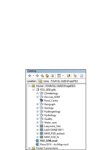
The project’s geodatabase is named “FEO_GDB”,
and it includes features, feature classes, feature data
sets, relationships and rasters. Features are spatial
vector objects (e.g., points, lines, polygons, and
multi-patches) with attributes (fields) to describe their
properties. The “FEO_GDB” is designed with a
thematic hierarchical architecture, including all
hydrogeological topics: geography, administration,
infrastructure, geology, hydrogeology, hydrology,
water uses, models, seawater intrusion, and allowing
producing thematic maps (Figure 1).
Figure 1: The thematic structure of the geodatabase.
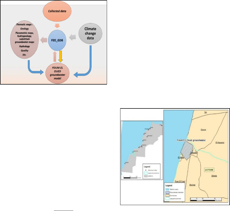
The FEO geodatabase is used all among our
project to prepare and interrogate data for each
project thematic, to produce inputs for the
groundwater model and to use the results from this
model to produce others outputs. The interaction
between the geodatabase and all the other project
steps is continuous and interactive (Figure 2).
Figure 2: Database objective’s organizational scheme.
2.3 Hydrological Modelling
The hydrological model is a mathematical
representation of the hydrological processes in a
watershed, such as the saquia Al Hamra river,
involving all the hydrologic cycle (rainfall,
evaporation, runoff, etc.).
Simulation of the last flood of the Saquia Al
Hamra river basin was made by applying the
Hydrologic Engineering Center’s Hydrologic
Modeling System HEC-HMS. It is designed to
simulate the rainfall-runoff processes of watershed
systems. The process used for our simulation is the
Soil conservation service (SCS) Curve Number (CN)
model that estimates the precipitation excess as a
function of cumulative precipitation, soil cover, land
use, and antecedent moisture, using the following
equation (1):
P
(1)
where P
e
=accumulated precipitation in time t, P =
accumulated rainfall depth at time t, I
a
= initial loss,
and S= potential maximum retention.
We also use other processes, the Clark unit
hydrograph for the transformation and a
meteorological model for the weather data used for
the simulation. For this latter simulation, we used and
applied the inputs provided from the data collected
from the National Direction of Meteorology (for
rainfall) and the Direction of Research and Planning
of Water (for flow rates).
3 GEODATABASE/GIS
EXPLOITATION FOR SITE
CHARACTERIZATION
3.1 Site Location
The Foum El Oued coastal aquifer is located in
Laâyoune province, in the south of Morocco, 20 km
west of Laâyoune city (Figure 3). It is a fresh
groundwater system that supplies the Laâyoune city
with drinking water and irrigation of an agriculture
area extended on the Foum El Oued plain. The study
area is located in an arid zone with a severe water
scarcity, exacerbated with the climate change impact
and increasing water demand, due to the socio-
economic development of the Laâyoune region.
Drinking water supply is ensured by both the
Laâyoune seawater desalinization unit (2/3) and the
Foum El Oued fresh groundwater aquifer (1/3) from
a pumping well field.
Figure 3: The Foum El Oued coastal aquifer location.
3.2 Geological Context
The Foum El Oued aquifer corresponds to the units
from the permeable late Miocene to Plio-Quaternary
geological formations. It is formed of a fluvio-lake
sediment, composed of complex sedimentary,
detrital, biochemical and chemical alternations.
These formations lie on an impervious substratum
composed of clay sediments from late Cretaceous to
late Miocene (Figure 4).
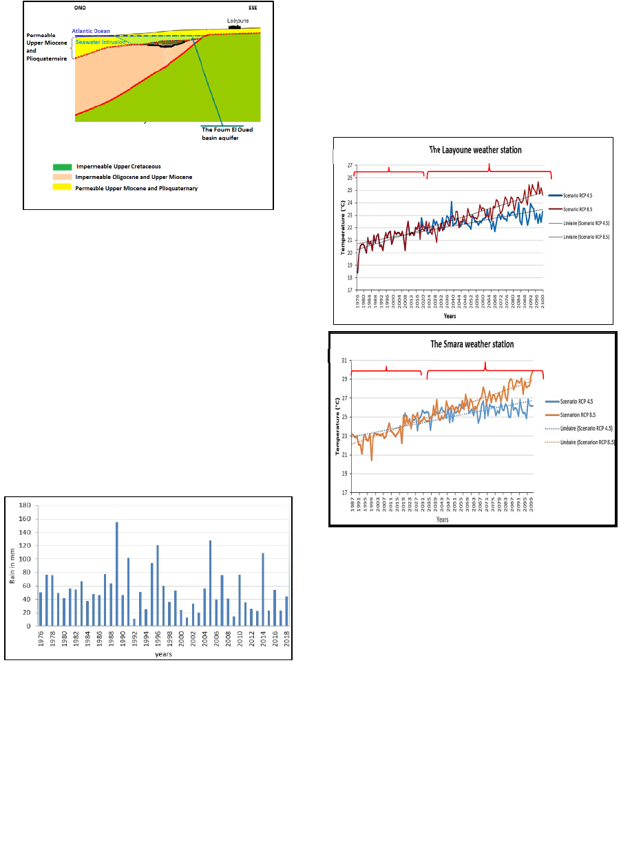
Figure 4: Geological schematic section of the Foum El
Oued area (DRHS, 2003).
3.3 Climate Context (past)
The prevailing climate in the study area is of the
desert type and very influenced by oceanic effects.
The temperature variations recorded in Laâyoune
weather station shows that August is the hottest
month of the year, with a maximum average of 27.7
°C, and December is the coldest month with a
minimum temperature of 15.2°C. The rain is very rare
in the study area, the annual rainfall values, recorded
in the Laâyoune weather station, between 1976 and
2018, range from 155 mm recorded in 1989 to 10.7
mm recorded in 1992 with an average value of 54.89
mm (figure 5).
Figure 5: Evolution of annual rainfall at Laâyoune weather
station, 1976-2018.
3.4 Climate Change Projections
In order to assess climate change at the regional level,
and with the objective of taking them into account in
the analysis, we worked with the regional climate
models (RCMs), which are the most suitable for the
project, in particular those from RICCAR, specific to
the Arab region (ACSAD and ESCWA, 2017). Thus,
we examine the projections of the two parameters,
temperature and rainfall, extracted from several
regional climate models and choose the most
appropriate results for RCP4.5 (moderate) and
RCP8.5 (extreme) scenarios (figures 6 and 7). The
extracted projections are relevant to two main local
weather stations (namely Laâyoune and Smara)
which are located respectively in downstream and
upstream of the Saquia Al Hamra basin.
Figure 6: Temperature projections for Laâyoune and Smara
weather stations until 2100.
These two figures show a trend of increase in
temperatures for both weather stations and for both
scenarios. However, these projections predict more
increase in temperature values for the Smara weather
station, exceeding the maximum of the recorded
averages (24.4 °C).
The increase is obviously greater
for scenario RCP8.5 than that of RCP4.5, where
temperature will exceed 24 °C before 2050. The
temperature projections for Laâyoune station show
also an overall increasing trend in mean temperature,
but it is more marked for RCP 8.5 than for RCP4.5.
The projections of rainfall in Laâyoune station
indicate that for the RCP4.5 scenario there will be
increasing trend, which is unlike the prediction for the
north-eastern regions of Morocco where there will be
an overall decrease in the rainfall. While, the RCP8.5
scenario will expect a precipitation decrease in the
global trend (Figure 7). However, for Smara weather
Observedvalues
Projections
Observedvalues
Projections
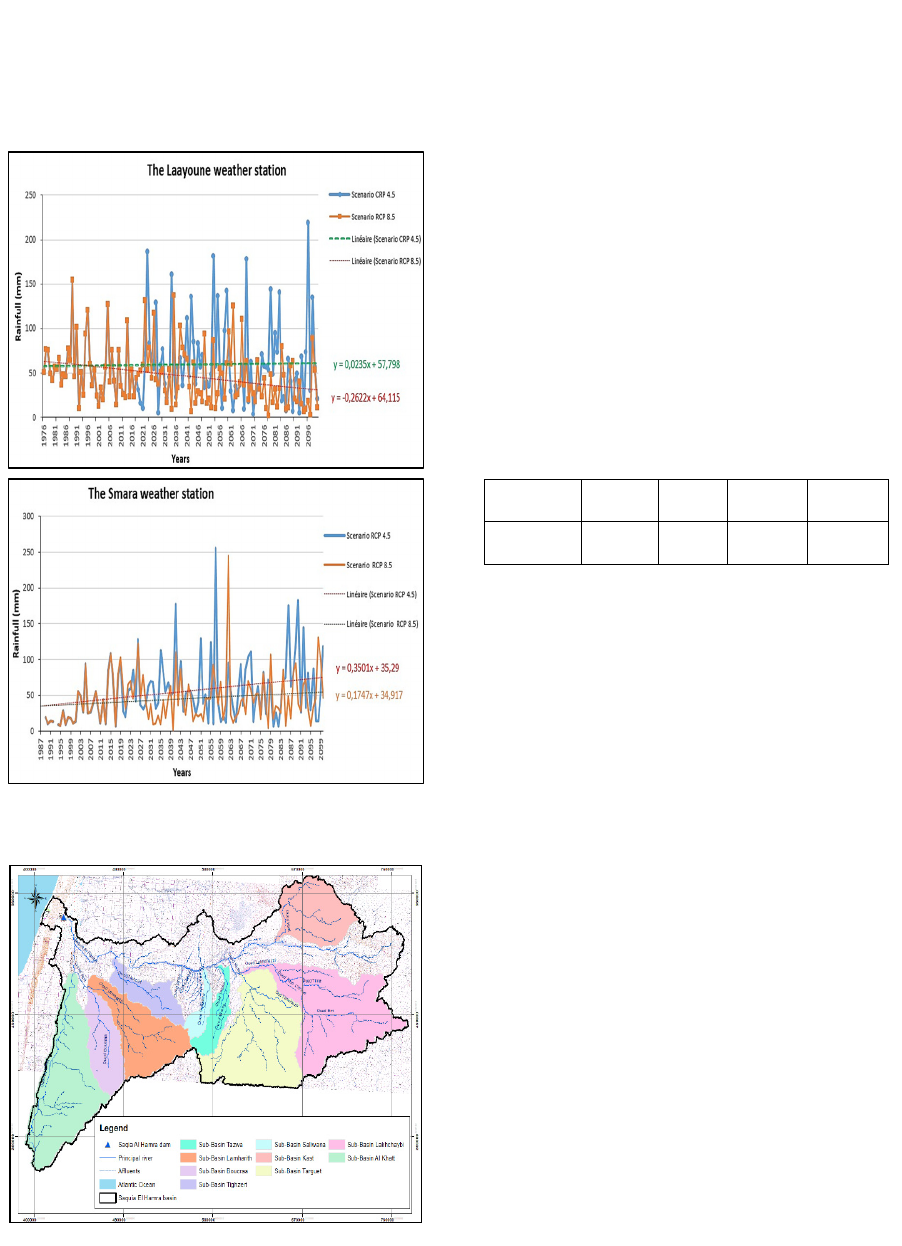
station, the projections predict an increasing of
rainfall for both scenarios. This will result in a
positive impact on the Foum El Oued aquifer
recharge, as the main recharge comes from the Saquia
Al hamra river floods of upstream sub-basins
covering the Smara area (Figure 8).
Figure 7: Rainfall projections for Laâyoune and Smara
weather stations.
Figure 8: Saquia Al Hamra watershed and its sub-basins
3.5 Characteristics of the Hydrological
Basin
The Saquia El Hamra is the main river of the Sahara
watershed which crosses the whole basin in its
northern part from east to west and having its outlet in
the study area (Figure 8), where floods are spreaded
over the plain before reaching (very rarely) the
Atlantic Ocean. The river length is 400 km and the
watershed is extended on a total area of 82 000 km
2
.
The river is characterized by a wide bed which can
reach 2 to 3 km in some sections, and the flow occurs
during heavy floods from upstream sub-watersheds.
The hydrographic network of the watershed
includes many rivers, the most important ones are
those of the left bank of the stream; El Khatt, Boucraa,
Tizert, Target, etc. (Figure 8). Table 1 below provides
some characteristics of the Saquia Al hamra river.
Table.1. Saquia Al Hamra river characteristics.
Basin/sub
-
b
asin
Area
(
Km
2
)
P*
(
km
)
CC*
CT*
(
hours
)
Saquia Al
Hamra
82 000 2346 1,43 95
P*: Perimete
r
CC*: compactness coefficient
CT*: Concentration time
3.6 Hydrogeology of the Foum El Oued
Aquifer
3.6.1 The Aquifer Substratum and
Thickness
The aquifers lie uncomfortably on an impermeable
substratum composed of predominantly clay
sediments from the Upper Cretaceous to Upper
Miocene (silto-sandy clays and marls of gray, green,
blackish or whitish colors). This substratum is
shallow to sub-outcropping to the east of the Foum El
Oued area, few kilometers west of the town of
Laâyoune (Figure 10). Based on the elevation digital
model (DEM) and the substratum map, we could
produce the thickness map of the Foum El Oued
groundwater aquifer, which shows that the aquifer
thickness varies between 20m (east of the basin) to
190m along the Atlantic coast (Figure 9).
3.6.2 The Piezometric Fluctuations
The Foum El Oued groundwater table is monitored
since 1977 via a network of observation wells made
up of 32 piezometers, which do not show continuous
records of measurements over the time. Based on the
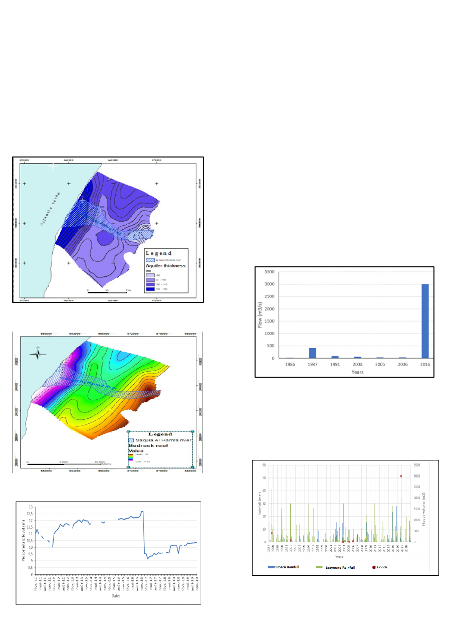
time series data collected from ABHSHOD for the
Foum El Oued aquifer, structured and processed in
the geodatabase, we were able to plot the piezometric
level evolution in observation wells as illustrated in
Figure 11. This latter clearly shows a decrease of the
groundwater level during 2011 due to operated
groundwater pumping by the National Office of
Drinking Water of Laâyoune (ONEE) and followed
by shutdown of some pumping wells. On the other
hand, we can clearly notice the groundwater level
increase during 2016 due to the Saquia Al hamra river
floods which have a positive impact on the
groundwater aquifer recharge.
Figure 9: The Foum El Oued aquifer thickness.
Figure 10: The Foum El Oued aquifer substratum.
Figure 11: Piezometric time series for a monitoring well
installed in the aquifer.
4 HYDROLOGICAL MODEL
4.1 The Saquia Al Hamra Floods
The hydrographic network of the watershed includes
many rivers and streams as illustrated by figure 8.
Surface water flow of the Saquia Al Hamra river is
controlled by a downstream dam, located just
upstream of the study area, and the only major dam
reservoir of the basin, with a storage capacity of 410
Million m
3
(Mm
3
). In the downstream of this dam, the
river’s bed is represented by large sand dunes at the
level of Foum El Oued aquifer, which contribute
favourably to the aquifer recharge.
The hydrological regime of the Saquia El Hamra
river is marked by a strong seasonal and inter-annual
irregularity. The maximum inflow occurs during
major floods from upstream sub-watersheds, when
the rainfall is very important in the upstream of Smara
region (Figure 12). The flood frequency of the Saquia
El Hamra river is about two to five years at Laâyoune
dam (Figure 13).
Figure 12: Historical floods of Saquia Al Hamra river
The last flood of October 2016 has recorded a pick
flow of 3000m
3
/s. This flood whose flow has caused
the rupture of the dam and carried away the dike, has
never been recorded before in the catchment.
Figure 13: The occurrence of Saquia Al Hamra floods
within the rainfall upstream (Smara) and downstream
(Laâyoune) of the basin.
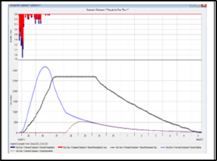
4.2 Last Flood Simulation (2016)
The simulation is made by applying the Hydrologic
Engineering Center’s Hydrologic Modeling System
HEC-HMS. For this purpose, we used data collected
from the DMN and the observed flow rates of the
Saquia Al Hamra river at the level of Smara-Tantan
bridge, as recorded by the DRPE (DRPE, 2016). The
model was then calibrated in order to find out the
parameters allowing adjusting the observed values to
those obtained by simulation. Several parameters have
been calibrated such as the CN and the storage
coefficient. Figure 14 gives the preliminary results
obtained after several tests. These results will be
improved by the calibration and by introducing others
relevant parameters to the study area, and by using
other modeling tools taking into consideration the
topographic characteristics variation in the basin. The
modelling part is going on to improve these results and
to assess the aquifer recharge from floods as main
input in the groundwater flow model. The natural
aquifer recharge from precipitation for 2020 – 2100 is
already evaluated based on the DMN and RICCAR
time series of projected rainfall, but it would not be so
significant compared to the flood recharge (Larabi et
al. 2020).
Figure 14: Simulated results by HMS hydrological model.
5 CONCLUSION
The results of the IT tools developed for this project,
such as the regional geodatabase /GIS and the
hydrological model of the Saquia Al Hamra river
floods that mainly supply the aquifer recharge, and
which was not taken into account in the past, are of
great importance for developing the groundwater
models. The geodatabase and hydrological modelling
have led to important results on climate change,
hydrology and groundwater characterization for the
Foum El Oued aquifer and the Saquia Hamra river
basin. This helps also the decision maker to monitor,
control and mange water resources in the site.
Additionally, these two IT steps provide the
necessary inputs for the groundwater model which
will be a key decision support system for the decision
makers in water resources management, especially
for water supply of Laâyoune population, irrigation
of the Foum El Oued agriculture area and protection
of the aquifer from seawater intrusion. This
management should take into consideration the
climate change adaptation, especially when the
projections show positive evolution of the rainfall in
the upstream basin.
ACKNOWLEDGEMENT
Data collected for this project have been provided by
national organisations and the data for the climate
change projections have been provided by UN-
ESCWA-Beirut. We would like to thank them all for
their full support.
REFERENCES
ABHSHOD, 2007. Etude hydrogéologique du complexe
aquifère du bassin de Saraha, mission 1 et 2, rapport
intermédiaire N°1 et 2. Agence du bassin Hydraulique
de Saquia Al hamra Oued Dahab, Laâyoune Maroc.
ACSAD and ESCWA, 2017. Impact of Climate Change on
Extreme Events in Selected Basins in the Arab Region,
RICCAR report, https://arabsdgs.unescwa.org/en/read-
digital-library/impact-climate-change-extreme-events-
selected-basins-arab-region.
DRHS, 2003. Etude de Modélisation de la Nappe De Foum
El Oued Région de Laâyoune- Mission 1 : Synthèse
hydrogéologique. Direction de la Recherche et de la
Planification de l’Eau, Rabat, Maroc.
DRPE, 2016. Rapport crues de l’oued Saquia El Hamra du
25 au 30 octobre, 2016 Mission de Diagnostic.
Secrétariat d’Etat auprès du Ministère de l’Equipement,
du transport, de la Logistique et de l’Eau, chargé de
l’Eau, Rabat, Maroc.
El Mokhtar, M. Chibout, S. Kili, M. El mansouri, M. Chao,
J. El Kanti, S.M. Ntarmouchant, A. and Benslimane, A.,
2018, Evaluation de l’intrusion saline dans la nappe de
Foum El Oued, Province de Laâyoune, Maroc. Bulletin
de l’Institut Scientifique, Rabat, Section Sciences de la
Terre, n° 40, 53-69.
Larabi, A., Ait Oubaha, N., EL Hamidi, M.J. et Faouzi, M.
2020. Modélisation de l’impact des changements
climatiques sur la nappe côtière de Foum El Oued
Laâyoune, Rapport technique du projet OCP, Centre
Régional de l’Eau du Maghreb, Ecole Mohammadia
d’Ingénieurs de Rabat.
USGS, 2005. MODFLOW-2005, The U. S. Geological
Survey Modular Ground-Water Model — the Ground-
Water Flow Process, USGS Report, 253p.
