
Bench Mark Measurement and Situation Detailed Mapping on
Sembulang, Batam City
Oktavianto Gustin
1
, Arif Roziqin
1
, Sudra Irawan
1
, Meivy Carolina Pandey
1
, Cindy Kasari Miswan
1
and Dika Aya Safitri
2
1
Geomatics Engineering, Politeknik Negeri Batam, Batam, Indonesia
2
Southern Federal University, Rostov,Russia
Keywords: Mapping, Land Field, Topography, Benchmark.
Abstract: Mapping is an activity aimed at providing information about a region and presenting in the form of maps.
Land fields are defined as the surface of the earth which is a restricted field unit. The field mapping is done
by measuring the position of the boundary points of the land to get the certainty in the area of the Earth.
Mapping activities on this study were conducted on a terrestrial and extra-terrestrial basis. This research was
conducted in Sembulang, Galang Sub-district, Batam City to get information about the state of topography in
the area. The survey activities included Benchmark (BM) measurement and situation details mapping. In this
study the detailed measurements of the situation represented the measurement of the points that form polygons,
the boundary points of the road, and the boundary points of the land area. This research was conducted so BM
point coordinate, and topographic maps were obtained. The data collection and processing techniques of this
research are conducted using observation methods to the field which are conducted on a terrestrial and extra-
terrestrial basis. The measurement in this study resulted Benchmark point with X coordinate: 417552; Y:
93084.8; Z: 14.333. The Topographic map describes the object details of the situation resulting from this
research are obtained objects like a coconut tree, Street & Bridge Detail, Borderline, Shore, Sea, Gazebo, Tree,
and Power Pole, Fence, Parcel Boundary.
1 INTRODUCTION
Mapping is an activity aimed at providing
information about a region and presenting in the form
of maps (Wicaksono, 2016). The need for measuring
and mapping the land field in Indonesia is still very
high where there are still many areas of land that have
not been mapped (Adi, 2017). Measurement and
mapping of land field is a series of activities in the
registration of land (Ramadhony, 2017). Land fields
are defined as the surface of the earth which is a
restricted field unit. The field mapping is done by
measuring the position of the boundary points of the
land to get the certainty in the location of the land in
the surface of the Earth (Setiadi, 2013). Mapping land
parcels can later have an impact on land use and
needed for development purpose (Gustin & Roziqin,
2019; Roziqin, Gustin, & Syari, 2018). The method
of positioning a point on the Earth surface can be
distinguished into two parts, namely: The method of
measuring both terrestrial and extra-terrestrial
(Abidin, 2007). On the measurement by terrestrial
means, use the ETS (Electronic Total Station)
measuring device is now commonly used and as well
as point-position measurements with an extra-
terrestrial method using the GNSS receiver RTK
(Setiadi, 2013).
The mapping activities on this research are
conducted on a terrestrial and extra-terrestrial basis.
This research was conducted in Sembulang, Galang
Sub-district, Batam City to get information about the
topography in the area. This survey included
construction of Benchmark Point (BM) and
measurement of the situation details. This research
aims to construct BM points, and presenting
topographic maps. These activities include
measurement, data retrieval, and GNSS data
processing for the BM points and processing of
detailed situation data. It is hoped that this research
activity can serve as a reference source that can
support the local community.
Gustin, O., Roziqin, A., Irawan, S., Pandey, M., Miswan, C. and Safitri, D.
Bench Mark Measurement and Situation Detailed Mapping on Sembulang, Batam City.
DOI: 10.5220/0010352100850088
In Proceedings of the 3rd International Conference on Applied Engineering (ICAE 2020), pages 85-88
ISBN: 978-989-758-520-3
Copyright
c
2021 by SCITEPRESS – Science and Technology Publications, Lda. All rights reserved
85
2 RESEARCH METHOD
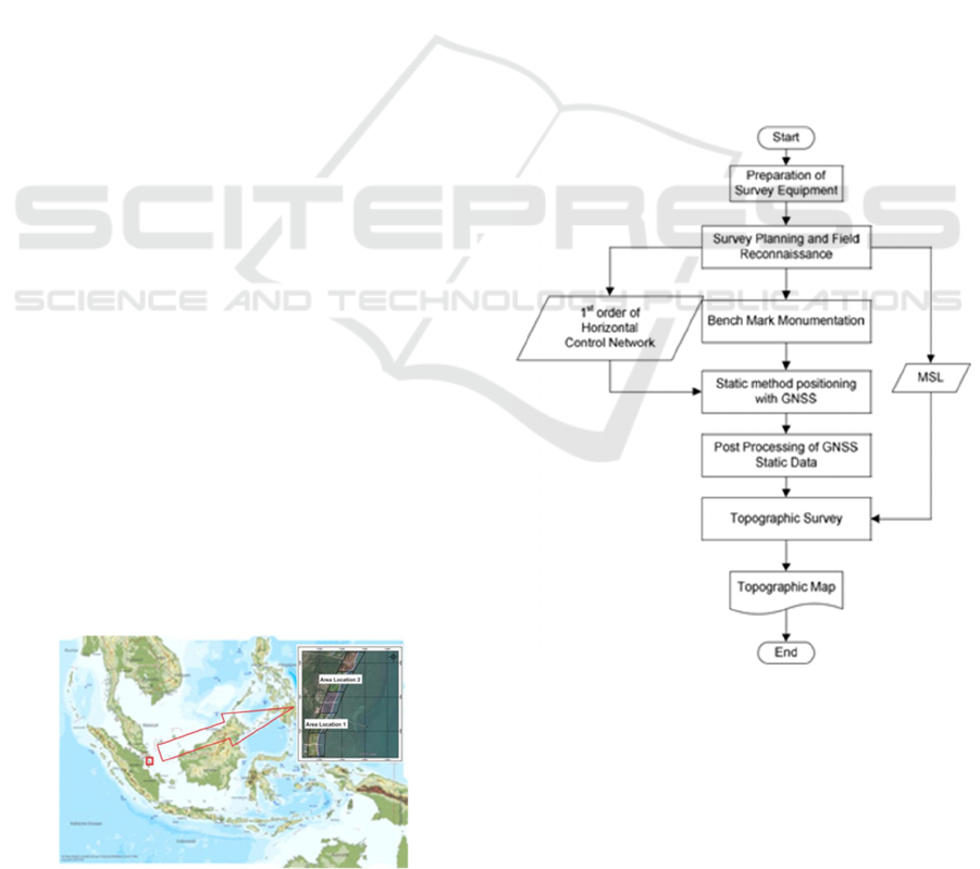
2.1 Research Location
The research is conducted in Sembulang, Galang
subdistrict, Batam City. The research area of the study
was in the measuring area of Location 1 and Location
2. The research location can be seen in the Figure 1.
2.2 Tools and Materials
In measurement activities, of course, the supporting
activities of measurement activities are used in the
field. The tools used in this research include:
1. Software: Microsoft Office 2010, Micrsoft
Excel 2010, Autocad Civil 3D 2018 Metric,
Magnet Tools.
2. Hardware: Statif, GR-5 GNSS Geodetic,
Monopole, Electronic Total Station (ETS),
tape measure, and Prism Detail.
2.3 Tools and Materials
The data collection and processing techniques of this
research are conducted using observation methods at
the field. Surveys in this study were conducted with
the intention to BM points measurement and gather
information about the topographical state of the
situation. The flow of research carried out is shown in
Figure 2.
The study was included in a descriptive research
category using a survey method intended to collect
information relating to the research conducted. The
survey method of research conducted consists of
Benchmark measurement using GNSS Static Method
and Situation detailed measurement data collection
using Electronic Total Station. In this study the
detailed measurements of the situation were not all
measured in full, but will be represented by the
measurement of the field boundary points consisting
of: the points that form the polygons, the boundary
points of the road, and the points of field boundaries
land.
Figure 1: Research Location.
Field data measurement is done by measuring
start of the polygon point position by GNSS RTK and
ETS on every road, polygon points, and land area. At
GNSS RTK measurements must have a minimum of
2 receivers, one receiver is used as the Base (receiver
station) and the second receiver is used for the Rover.
with GNSS measurements higher position accuracy
can be obtained such as Determination and
Measurement of Horizontal Control Points study
(Gustin, Roziqin, & Fatulloh, 2018). The research
results are focused on giving an overview of the
actual state on the object of interest.
The Measurement of BM point in this research
required the stage of site survey and control point
network before performing the observation and
retrieval of data. The creation of topographical map
requires detailed data of the situation in XYZ, in the
detailed processing of the situation, in the need of the
elevation correction phase of each detail of the
situation based on the value of Mean Sea Level
(MSL) through transfer of the palm elevation of the
beach to the main. The detailed elevation correction
of the situation can be seen in Table 1.
Figure 2:
Research
flow chart.
ICAE 2020 - The International Conference on Applied Engineering
86
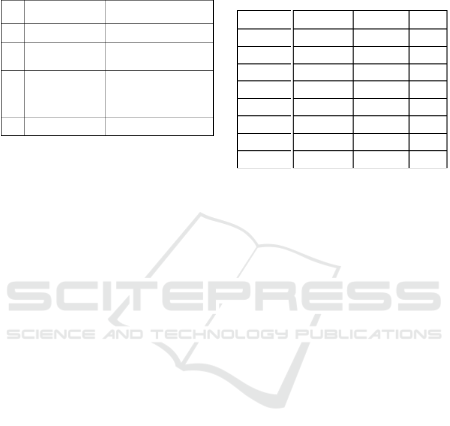
Table 1: Phase elevation correction formula.
No
Elevation
Correction Sta
g
e
Formula
1
BM Elevation by
MSL
ZBM(msl) = ∆H (Tidal Palm
to BM)
–
ms
l
2
Corrected elevation
of Connective point
in the research area
A = ZBM(msl) + ∑∆H
previous point
3
Corrected elevation
the connective point
in the study area
Pt(1).kor = A + ∆H Pt(1) to A
Pt(2).kor = Pt(1) + ∆H Pt(2) to
1
Pt(n).kor = Pt(n-1) + ∆H Pt(n)
to n
4
Corrected Detail
Object Elevation
O.kor = (Pt – O) + A.kor
Information
1. ∆ H : The high difference in the
elevation transfer from Palem Pasut-BM
2. MSL : Average-surface of the sea
water
3. ZBM (MSL): BM elevation by MSL
4. A : Corrected elevation of
Connective point in the research area
5. Pt (N). Kor : Corrected elevation of the
connective point in the study area
6. Pt : Elevation of Connective point
of study area
7. O : Detail Object elevation
8. O. Kor :Corrected Detail Object
elevation.
3 RESULT AND DISCUSSION
3.1 Benchmark Point Measurement
and Determining the Boundaries of
the Research Area
Measurement of Benchmark Point on this research is
done by GNSS observation static method for 8 hours
with the network model that is between Politeknik
Negeri Batam to Sembulang, Sembulang against
Politeknik Negeri Batam, and Politeknik Negeri
Batam to Hang Airport Nadim. The result of 8 hours
of observation resulted in Benchmark point
coordinates in the form of X, Y, Z used as a main
point in Sembulang village. Benchmark Point
coordinates can be seen in Table 2. The research site
is divided into 5 areas of study. The determination of
the area boundaries of research studies is conducted
using the RTK method, the result of determining the
region boundary using the RTK can be seen in Table
2.
Table 2: Benchmark coordinates and region boundary
coordinates.
Point E N Z
B
enchmark
417,552
93,084.8
14.333
B11
417,577.729 93,326.744
13.99
B12
417,611.287 93,370.918
12.638
B14
417,639.154 93,391.808
12.141
B15
417,605.65 93,430.167
12.105
B16
417,634.933 93,483.443
14.82
BT1/T3
417,758.057 93,649.061
13.48
BT2/T2
417,695.305 93,459.678
12.897
3.2 Topography Maps
The result of the situation detailed mapping with the
Figure 3. Topographic Map of Location 11:655 scale
and the 1: 555 scale with a contour interval 0.5 meters
for the measurement area of Group 4 and Group 2, the
representation of the topographical map using
AutoCAD Civil 2018. Topographic map of Location
1 measurement area and Location 2 in Figure 3 and
Figure 4.
Figure 3 and Figure 4 described detailed
measurements of the situation resulting from this
research are obtained objects like a coconut tree,
Bridge, borderline, Shore, Sea, Gazebo, Street, Tree,
and Power Pole.
4 CONCLUSIONS
Based on the objectives and results of the study, it can
be concluded that:
1. the data collection and processing
techniques of this research are conducted
using observation methods to the field which
are conducted on a terrestrial and extra-
terrestrial basis.
2. the measurement in this study resulted
Benchmark point with X coordinate:
417552; Y: 93084.8; Z: 14.333.
3. the Topographic map describes the object
details of the situation resulting from this
research are obtained objects like a coconut
tree, Street & Bridge Detail, Borderline,
Shore, Sea, Gazebo, Tree, and Power Pole,
Fence, Parcel Boundary.
Bench Mark Measurement and Situation Detailed Mapping on Sembulang, Batam City
87
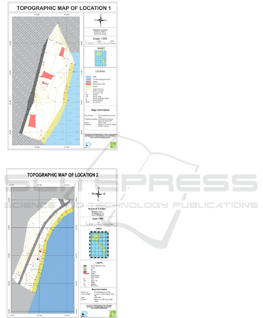
Figure 3: Topographic map of location 1.
Figure 4: Topographic map of location 2.
REFERENCES
Abidin, H. Z., 2007. Penentuan posisi dengan GPS dan
aplikasinya, PT Pradnya Paramita. Jakarta.
Adi, A. P., 2017. Pengujian Akurasi Dan Ketelitian
Planimetrik Pada Pemetaan Bidang Tanah Pemukiman
Skala Besar Menggunakan Wahana Unmanned Aerial
Vehicle (Uav). Jurnal Geodesi Undip, 208-217.
Gustin, O., Roziqin, A, 2019. Detection of land use changes
in Batam Island coastal using remote sensing. in IOP
Conference Series: Earth and Environmental Science
Science. IOP Publishing.
Gustin, O., Roziqin, A., Fatulloh, A., 2018. Determination
and measurement of horizontal control points 2nd
order. In 2018 International Conference on Applied
Engineering (ICAE). IEEE.
Ramadhony, A. B., 2017. Analisis Pengukuran Bidang
Tanah Dengan menggunakan GPS Pemetaan. Jurnal
Geodesi Undip, 305-315.
Roziqin, A., Gustin, O., Syari, I. P., 2018. Landslide
distribution using geographic information system in
batam island. In 2018 International Conference on
Applied Engineering (ICAE). IEEE.
Setiadi, J., 2013. Aplikasi GPS RTK untuk Pemetaan
Bidang Tanah. Reka Geomatika, Vol. 1.
Wicaksono, R., 2016. Pembuatan Peta Situasi Skala 1: 500
Dusun Serang Desa Sendangsari Kecamatan Pengasih
Kabupaten Kulon Progo, Universitas Gadjah Mada.
ICAE 2020 - The International Conference on Applied Engineering
88
