
Mapping of Physical and Chemical Parameters of Seaweed
Cultivation Area in Geranting Island Waters
Oktavianto Gustin
1
, Muhammad Zainuddin Lubis
1
, Arif Roziqin
1
, Tri Agus Pertiwi
1
,
Budhi Agung Prasetyo
2
1
Geomatics Engineering, Politeknik Negeri Batam, Batam, Indonesia
2
Marine Environmental Science, Institut Teknologi Sumatera, Lampung, Indonesia
Keywords: Seaweed, Interpolation, Temperature, DO, pH, Visibility
Abstract: Seaweed is a marine resource that has very high value. In addition, seaweed cultivation is easy because it
takes a relatively short time, requires a small fee, and also the need for seaweed continues to increase. This
study aims to determine the relationship between each parameter of both physical and chemical marine
seaweed cultivations in the location and present it in the form of maps. The study was conducted in the waters
of Geranting Island, Belakang Padang District, Batam City. in this study, parameters were measured directly
in the field and using interpolation to determine the value of the surrounding parameters. The parameters in
this study are temperature, dissolved oxygen (DO), pH, and Visibility. The final results of this study are maps
of Physical and Chemical Parameters of the Sea between stations. The temperature obtained from stations 1-
4 ranged from 28.1 - 29.7 0C, the results of the Visibility ranged from 1.5 - 2.5 m, the DO values ranged from
21.7 - 29 mg/L, and for pH values ranged between 4.8 - 4.9. According to the field data temperature parameters
at all stations, and visibility parameters at stations 2, 3, 4 are suitability with seaweed cultivation area. Based
on the field data visibility parameters at Station 1, pH, and DO parameters at all stations are not suitable with
seaweed cultivation criteria. Information of the distribution of physical and chemical parameter values of the
waters in the Geranting Island seaweed cultivation can be seen in the resulting maps.
1 INTRODUCTION
Batam City is one of the cities in Indonesia which has
a larger sea area than the land area. Batam is one of
the cities in Indonesia with large industrial,
residential and commercial land needs (Gustin and
Roziqin, 2019), it continues to grow rapidly
according to previous studies (Gustin, Roziqin, &
Fatulloh, 2018; Roziqin, Gustin, and Syari, 2018).
Thus in the city of Batam, it has abundant marine
natural resources. One of the marine natural resources
in Batam is seaweed. Lately, seaweed has many
advantages such as in the field of trade, which is very
famous in the world. This seaweed cultivation can
improve the economy of the people in Batam City
because of the high demand and needs of the
seaweed.
Water conditions are very important to consider
by taking into account the state of the physical
parameters of the sea including sea surface
temperature, water brightness and dissolved oxygen
available in the water (Antoni, et al., 2019; Lubis, et
al., 2018). Some things to consider and excel are,
among others, wide open export market
opportunities, relatively stable prices, there are no
trade restrictions or quotas for seaweed, the
cultivation technology is simple so it is easy to
master, the cultivation cycle is relatively short, capital
requirements are relatively small, commodities which
are irreplaceable because there is no synthetic
product.
The seaweed cultivation business is classified as a
labor-intensive business that can absorb labor
(Rajagukguk, 2009). Therefore, further research can
be done on the physical and chemical parameters of
marine seaweed cultivation in Batam so that people
in Batam know the importance of marine physical and
chemical parameters for seaweed cultivation. In
conducting this research, the physical parameters are
temperature and visibility, while the chemical
parameters of seawater are pH and Dissolved Oxygen
(DO). in this study, parameters were measured
directly in the field and using interpolation to
determine the value of the surrounding parameters.
58
Gustin, O., Lubis, M., Roziqin, A., Pertiwi, T. and Prasetyo, B.
Mapping of Physical and Chemical Parameters of Seaweed Cultivation Area in Geranting Island Waters.
DOI: 10.5220/0010351600580063
In Proceedings of the 3rd Inter national Conference on Applied Engineering (ICAE 2020), pages 58-63
ISBN: 978-989-758-520-3
Copyright
c
2021 by SCITEPRESS – Science and Technology Publications, Lda. All rights reserved
A lot of industrial activities, dense settlement and
sea transportation in the west coast of Batam Island,
Riau Islands has the opportunity to make a major
contribution to the heavy metal content in the region.
Research on water conditions by looking at the
condition of physical parameters is very useful to
provide information for the future.
Table 1: Criteria fitness for seaweed cultivation
(Ardiansyah et al., 2016).
N
o Parameter The
Range
Appropriateness Reference
1 Temperature
(c)
28-31 25-30 Ditjenkanbud,
2005
2 Salinity
(
0
/
00
)
30-33 28-33 Anggadiredja
et al., 2008
3 pH 8 6-9 Aslan, 1998
4 DO (ppm) 3.2-
7.8
3-8 Ditjenkanbud,
2008
5 Visibility
(m)
2.1-
2.4
2-15 Anggadiredja
et al., 2008
6 Depth (m) 4.6-
5.1
0.2-0.4 Poncomuyo
et al., 2006
7 Current
strength
(m/s)
0.1-
0.2
0.2-0.4 Anggadiredja
et al., 2008
8 Nitrate
(mg/l)
0.05-
0.06
0.02-0.04 Effendi,
2003
9 Phosphate
(mg/l)
0.05-
0.07
0.02-1.0 Sulistijo,
1996
Seaweed is one of the marine plants that are
classified in benthic macro algae, which is more
inherent in the seabed. Seaweed is algae that lives in
the sea and belongs to the thallophyta division.
Classification of seaweed-based on pigment content
consists of 4 classes, namely green seaweed
(Chlorophyta), red seaweed (Rhodophyta), brown
seaweed (Phaeophyta) and blond seaweed
(Chrysophyta). This seaweed is a group of marine
plants that have indistinguishable properties between
the roots, stems, and leaves. All parts of the plant are
called a thallus, so seaweed is classified as a low-level
plant (Dahuri, 2003).
2 RESEARCH METHODS
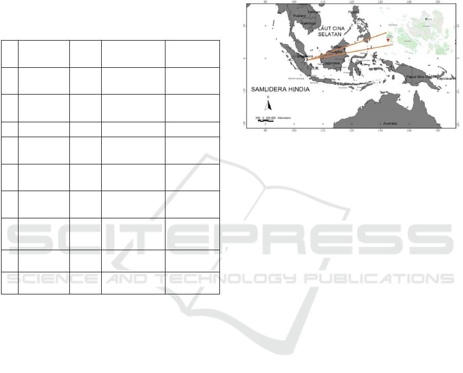
2.1 Research Sites
The research activity was carried out in Geranting
Island Waters, Belakang Padang District. The
location can be seen in Figure 1. The material used in
this study is the primary data. The primary data in the
form of sea surface temperature, water brightness,
and dissolved oxygen distribution were measured in
situ in 2017. The data processing was carried out at
Politeknik Negeri Batam.
Figure 1: Research location.
2.2 Tools and Materials
The tools used are laptops, cellphone cameras, GPS
Garmin GPSMap 78S, DO meters, pH meters, Secchi
disks, Thermometers, stationery. The material used is
the Batam City Administration Map.
2.3 Methods
The field survey was conducted to test the field
validation by taking temperature, dissolved oxygen
(DO), pH, and visibility parameters. Temperature
parameters are taken using a thermometer, dissolved
oxygen using a DO meter, the pH uses a pH meter,
and the visibility is taken using a secchi disk with the
formula (1), whereas the T value is the visible value
and TT is the invisible value from the results of data
retrieval with Secchi disk. The research flow can be
seen on Figure 2.
Visibility = (T + TT) /2 (1)
2.4 Research Procedure
Data collection and processing as in Figure 2 research
flow diagram, the details are as follows:
determine the suitable location for doing
research,
prepare survey tools,
perform calibration on the survey tools,
Mapping of Physical and Chemical Parameters of Seaweed Cultivation Area in Geranting Island Waters
59
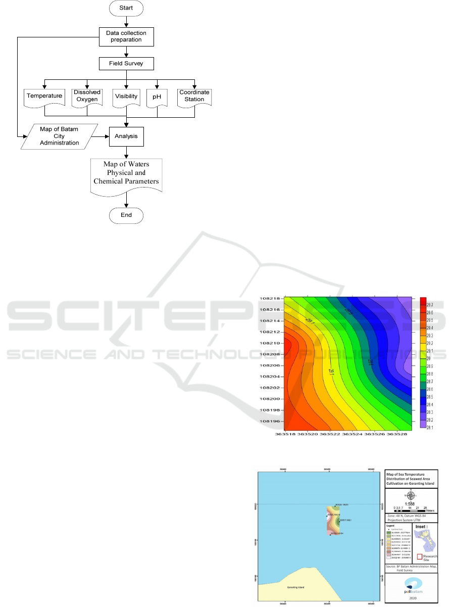
Figure 2: Research flow chart.
next, start doing field measurements to get
the coordinates, visibility, temperature, DO,
and pH.
display graphs on each parameter using
Microsoft Excel software.
make a contour map of the relationships
between parameters using a Surfer.
and make a map of each parameter using
Arcmap.
3 RESULT AND DISCUSSION
3.1 The Results of Temperature
Parameter Data
The results of Temperature Parameter Data come
from a field survey at 4 stations. Station 1 has a value
of 28.3
0
C, station 2 has a value of 28.1
0
C, station 3
has a value of 29.7
0
C, and station 4 has a value of
29.5
0
C. Seen from table 1 for its temperature, the four
stations include the appropriate criteria because the
temperature suitability values range from 25-30
0
C.
These results indicate that the temperature of the
waters is relatively stable and can be interpreted as
stable sunlight (intensity) in this region because the
high and low temperature of the waters is very
dependent on the intensity of sunlight. Vertical
distribution of temperature can be seen on Figure 3.
Figure 3 is the result of the vertical distribution
between temperature and location. In the vertical
distribution of temperature, there is a low value of
28.1
0
C around the area of station 1, and the highest
value is 29.7
0
C around the station areas 2, 3, and 4.
Based on Figure 4, it can be seen that the
temperature distribution value of the research
location is in the range of 28.3-29.5
0
C.
3.2 The Results of Visibility Parameter
Data
The results of Visibility Parameter Data come from a
field survey at 4 stations. Station 1 has a value of 1.5
m, station 2 has a value of 2 m, station 3 has a value
of 2.5 m, and station 4 has a value of 2 m. Seen from
Table 1, only stations 2, 3, and 4 could fulfil the
criteria, while station 1 is not appropriate because the
suitability value for visibility is in the range of 2-15
meters. From observations in the field, the obtained
visibility value of 2-15 m. It shows that the value of
the intensity of the sun entering the waters is quite
high. This condition shows that waters have very low
dissolved organic matter content. Vertical
distribution of visibility can be seen in Figure 5.
Figure 3: Temperature vertical distribution.
Figure 4: Map of sea temperature distribution.
ICAE 2020 - The International Conference on Applied Engineering
60
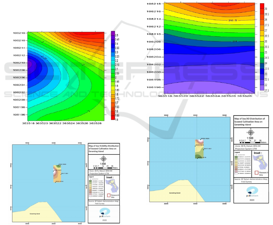
Figure 5 is the result of the vertical distribution
between visibility and location. In the vertical
distribution of visibility, there is a low value of 1.5 m
around the area of station 3, and the highest value is
2.5 m around the station areas 2.
Based on Figure 6, it can be seen that the visibility
value of the research location is in the range of 1.5-2
meters.
3.3 The Results of Dissolved Oxygen
(DO) Parameter Data
The results of the DO Parameter Data is from a field
survey at 4 stations. Station 1 has a value of 29 mg/L,
station 2 has a value of 22.9 mg/L, station 3 has a
value of 23.9 mg/L, and station 4 has a value of 21.7
mg/L. Seen from Table 1, the four stations are
included in the criteria that are less appropriate
because the suitability value for DO is in the range of
3-8 mg / L.
Figure 5: Visibility vertical distribution.
Figure 6: Map of sea visibility distribution.
Figure 7 is the result of the vertical distribution
between DO and location. In the vertical distribution
of DO, there is a low value of 21.5 mg/L around the
area of station 4, and the highest value is 29 mg/L
around the station areas 3. The value of dissolved
oxygen in the waters of the isthmus produces a value
that is between 21.5-21.9 mg/L. The condition of
sunlight fluctuates between bright light and dim light.
During the process of sunlight, the activity of
photosynthesis is a major factor in the provision of
some dissolved oxygen in the waters of the island of
Genting. When the sun sets, diffusion of oxygen from
the atmosphere is the biggest contributor to dissolved
oxygen in addition to the movement of water mass
(turbulence).
Based on Figure 8, it can be seen that the DO
value of the research location is in the range of 21.7-
29 mg/L.
Figure 7: DO vertical distribution.
Figure 8: Map of sea DO distribution.
3.4 The Results of pH Parameter Data
The results of pH Parameter Data come from a field
survey at four stations. Station 1 has a value of 4.9,
station 2 has a value of 4.8, station 3 has a value of
Mapping of Physical and Chemical Parameters of Seaweed Cultivation Area in Geranting Island Waters
61
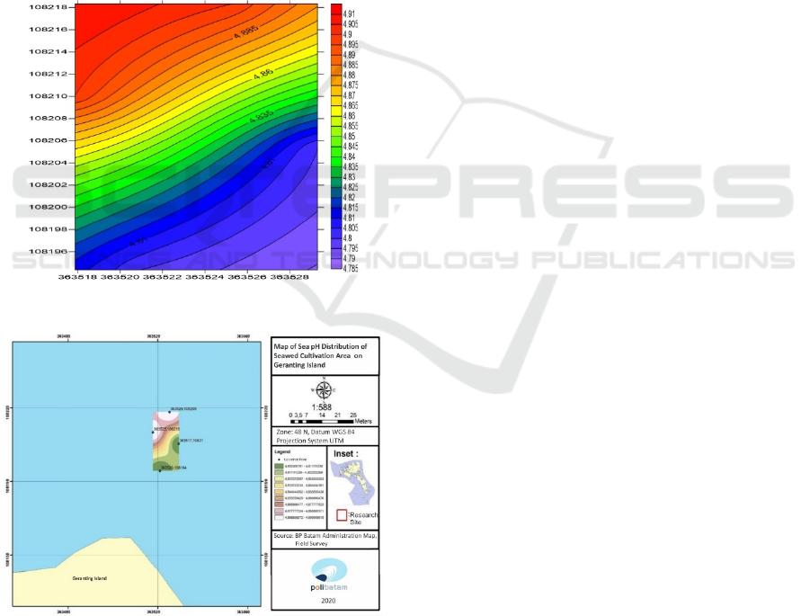
4.9, and station 4 has a value of 4.8 mg/L. Seen from
table 1, the four stations are included in the criteria
that are less appropriate because the suitability value
for pH is in the range of 6-9. The observations found
that the waters are in the pH range from 4.8 to 4.9
and the salinity of around 33 ‰. These results show
that these waters are quite stable and meet the criteria
as the location of waters that have not been polluted,
and these waters can be categorized as waters that are
can be used as a place of cultivation.
Figure 9 is the result of the vertical distribution
between pH and location. In the vertical distribution
of pH, there is a low value of 4.8 around the area of
station 2 and 4, while the highest value is 4.9 around
the station areas 1 and 3. Based on Figure 10, it can be
seen that the pH value of the research location is in
the range of 4.8-4.9.
Figure 9: pH vertical distribution.
Figure 10: Map of sea pH distribution.
This shows that the waters of Lampung Bay are
included in fertile waters (Anggoro, 1983), where it
shows the results that suggest the distribution of the
values of the distribution of brightness, distribution of
dissolved oxygen and sea surface temperature which
can be categorized as fertile waters. The saturated
oxygen level will be reached if the dissolved oxygen
content of the waters is theoretically the same as the
dissolved oxygen level. Unsaturated oxygen levels
occur if dissolved oxygen levels are lower than
dissolved oxygen levels (Effendi, 2003).
4 CONCLUSIONS
Based on the objectives and results of the study, the
conclusions of this study are:
Field data temperature parameters at all
stations and visibility parameters at stations 2,
3, 4 meet the suitability criteria for
appropriate seaweed cultivation.
According to the field data visibility
parameters at Station 1, pH and DO
parameters at all stations are not following the
suitability criteria for appropriate seaweed
cultivation.
The resulting maps show the location and also
the distribution of physical and chemical
parameter values that exist in the seaweed
cultivation in Geranting Island waters.
REFERENCES
Anggoro, S., 1983. Permasalahan Kesuburan Perairan
bagi Peningkatan Produksi Ikan di Tambak. Diktat
Buku Kuliah MA Kesuburan Perairan, Semarang,
Universitas Diponegoro.
Antoni, S., Bantan, R. A., Al-Dubai, T. A., Lubis, M. Z.,
Anurogo, W., Silaban, R. D, 2019. Chlorophyll-a, and
Sea Surface Temperature (SST) as proxies for Climate
Changes: Case Study in Batu Ampar waters, Riau
Islands. In IOP Conference Series: Earth and
Environmental Science (Vol. 273, No. 1, p. 012012).
IOP Publishing.
Ardiansyah, Y., Ramadhan, M., Heriati, A., Salim, H. L.,
Purbani, D., Amri, S.N., Arifin. T., 2016. Kesesuaian
kawasan budidaya rumput laut di Teluk Saleh,
Kabupaten Sumbawa, Nusa Tenggara Barat. Jurnal
Segara, 12 (1), 11-19.
Dahuri, R., 2003. Keanekaragaman hayati laut: aset
pembangunan berkelanjutan Indonesia, PT Gramedia
Pustaka. Jakarta.
Effendi, H., 2003. Telaah kualitas air, bagi pengelolaan
sumber daya dan lingkungan perairan, Kanisius.
Jakarta.
Gustin, O., Roziqin, A, 2019. Detection of land use changes
in batam island coastal using remote sensing. In Iop
Conference Series: Earth and Environmental Science,
vol. 375, pp. 012001.
ICAE 2020 - The International Conference on Applied Engineering
62

Gustin, O., Roziqin, A., Fatulloh, A, 2018. Determination
and measurement of horizontal control points 2nd
order. In 2018 International Conference on Applied
Engineering (ICAE). IEEE.
Lubis, M. Z., Anurogo, W., Hanafi, A., Kausarian, H.,
TAKI, H. M., Antoni, S., 2018. Distribution of benthic
habitat using Landsat-7 Imagery in shallow waters of
Sekupang, Batam Island, Indonesia. Biodiversitas
Journal of Biological Diversity, 19(3), 1117-1122.
Rajagukguk, M. M., 2009. Analisis daya saing rumput laut
Indonesia di Pasar Internasional (Skripsi), Institut
Pertanian Bogor. Bogor.
Roziqin, A., Gustin, O., Syari, I. P., 2018. Landslide
distribution using geographic information system in
batam island. In 2018 International Conference on
Applied Engineering (ICAE). IEEE.
Mapping of Physical and Chemical Parameters of Seaweed Cultivation Area in Geranting Island Waters
63
