
Systematic Crowd Mobility Management to Avoid Catastrophic Disasters
of Human Stampedes: The Case of Mina Hajj
Nisrine Ibadah
1 a
, C
´
esar Benavente-Peces
2 b
, Khalid Minaoui
1
, Mohammed Rziza
1
and Mohammed Oumsis
1,3
1
LRIT Laboratory, Associated Unit to CNRST (URAC 29), IT Rabat Center, Faculty of Sciences,
Mohammed V University in Rabat, Morocco
2
ETS de Ingenier
´
ıa y Sistemas de Telecomunicaci
´
on, Universidad Polit
´
ecnica de Madrid,
Calle de Nikola Tesla sn, 28031 Madrid, Spain
3
High School of Technology, Mohammed V University in Rabat, Sal
´
e, Morocco
Keywords:
Mobility, Traffic Management, Human Crowd, Stoning, Hajj, Mina, Tent City.
Abstract:
Every year, the Holy city of Makkah hosts more than two million Muslims for the pilgrimage ’Hajj’. During
this event, a set of activities should be done by pilgrims. One of the rituals performed is throwing stones in
al-Jamarat area of Mina at pillars target. The throwing Jamarat is a paradigm of stoning the devil, as done by
the prophet Abraham. All pilgrims must reach the site at different times in specific hours of particular days.
However, this stoning ritual represents the most bottleneck ceremony where the area becomes packed at routes
and around pillars structure. The problem is that, unfortunately, humans cannot be controlled while they are
in a crowd. That takes this place a high safety hazard by increasing accidents’ probably which cause death
of many Muslims last few years. Inspired from this event, this paper presents a new human mobility models
which simulates stoning in Hajj by adopting a new design to solve the safety problems. This suggests control
huge crowds by conducting the relationship between the Jamarat basin, pilgrims, stoning performance, and
the impact of organizing the pilgrims in three rows around the Jamarat basin. This experiment estimate the
throwing time at each pillar in order to manage the temporal and spatial human movement inside the Jamarat
area. The simulation outcomes encourage adopting the new design to prevent crowd panic and disasters.
1 INTRODUCTION
Up to now, mobility modeling field cognizes a lot of
interests and research advancements. That especially
ever knows an important expanding of human or so-
ciability based mobility models. From the beginning
of 1990, biologists, physicists, and other groups of
researchers looked into human and animal movement
patterns. Their research detected that their motions
are heavily influenced by various factors like food
location, foraging, habitat, and tendency to create
groups as herds or communities, for instance, group
of soldiers or rescue workers. That can be applied
to diverse applications of Pocket Switched Networks
(PSN) (Trifunovic et al., 2017). Numerous mobility
patterns have also been suggested inspired by sociol-
ogy and social network. Therefore, There are based
a
https://orcid.org/0000-0002-3079-3115
b
https://orcid.org/0000-0002-2734-890X
on the argument that Humans have tendency to so-
cialize where they are governed by social aspects and
the nature of social structure of the belonging commu-
nity. Moreover, people are confined to their own so-
cial group and seldom move outside it. For example;
during their days, people are in office, the evening in
a pub or coffee shop and return home at night. Hence,
human mobility is more complex than animals that
stills till now under research.
The pilgrimage to Makkah at Saudi Arabia is one
of the five needed pillars of Islam. Muslims are
charged for this duty at least one time in their lifetime,
if they can financially and physically afford it. Over a
fixed five days, the holy Makkah hosts around 2 mil-
lion people. A population of international Muslims
that annually comes from more than 150 countries
from all the world. This event represents the largest
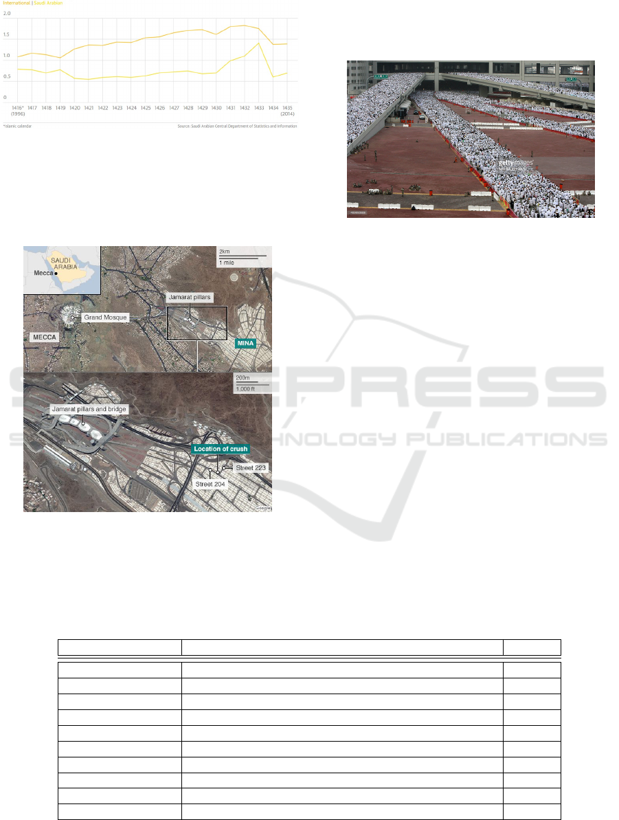
mass gathering of all the globe. Recently, the number
of pilgrims has exponentially multiplied, as shown in
Figure 1. That makes the Hajj a huge logistic issue
66
Ibadah, N., Benavente-Peces, C., Minaoui, K., Rziza, M. and Oumsis, M.
Systematic Crowd Mobility Management to Avoid Catastrophic Disasters of Human Stampedes: The Case of Mina Hajj.
DOI: 10.5220/0010147700660073
In Proceedings of the 10th International Conference on Pervasive and Parallel Computing, Communication and Sensors (PECCS 2020), pages 66-73
ISBN: 978-989-758-477-0
Copyright
c
2020 by SCITEPRESS – Science and Technology Publications, Lda. All rights reserved
repeated each year at the same time, at the same place
with more and more of hosted pilgrims.
Figure 1: Nationality of pilgrims at the Hajj by millions.
One of the focal points of pilgrimage is ’Stoning
of the Devil’ at the Jamaraat Bridge in Mina. That
comes few miles of Makkah and known as the ’Tent
City’, as depicted in Figure 2.
Figure 2: The tent city (Mina) location.
This area is a pedestrian zone that covers about
20 km
2
and from which pilgrims throw small stones
at the three Jamaraat pillars. During three successive
days, pilgrims throw at a target and hit it seven times
in sequence, starting with the smallest and finish with
the largest. However, the stoning ritual is conceived
the most bottleneck dangerous and unsafe process by
dint of cramped spaces, tight scheduling, and large
crowds.
Figure 3: Pedestrians’ flow in Jamarat plaza at Hajj.
Therefore, the pilgrimage has previously wit-
nessed several tragic stampedes and catastrophic
crowd disasters in the past. Basing on the civil
defense statement, the last scamper was happened
Thursday 24 September 2015 nearly at 09:00 am
(Mecca time) towards the Jamraat Bridge at the in-
tersection between 223 and 204 streets, as presented
in Figure 2. This disastrous accident is looked as
the deadliest stampede of the 21st century with 2110
deaths and about 863 were injured, as dramatically
shown in Figure 4.
Indeed, disasters are far from rare in Mecca, as
displayed in Table 1. There occur trampled of deaths
and suffocated people which are usually killed in
squeeze crushes. This large crowd necessitates de-
cisive control with the notably increase in the number
of pilgrims. The need for more researches that sug-
gests an efficient and new perfections for Hajj rituals
primarily in stoning. Inspired from all previous tragic
stampedes, this current paper proposes a new human
mobility model which manage and control movement
flows of pedestrians during the three consecutive days
Table 1: Tragic stampedes during Hajj.
Date What happened where Deaths
24 September 2015 Stampede at junction of streets 204 & 223 in Mina 2110
12 January 2006 Stampede at Jamarat Bridge in Mina 364
1 February 2004 27-minutes stampede during Jamarat stoning 251
11 February 2003 Stampede at Jamarat in Mina 14
5 March 2001 Stampede at Jamarat in Mina 35
9 April 1998 Stampede/overpass fall-off at Jamarat Mina 118
15 April 1997 Fire fuelled by high winds in tent city, Mina 343
23 May 1994 Stampede at Jamarat in Mina 270
2 July 1990 Stampede/suffocation in tunnel leading to Haram 1426
31 July 1987 Security forces break up anti-US demo by Iranian Hajis 402
Systematic Crowd Mobility Management to Avoid Catastrophic Disasters of Human Stampedes: The Case of Mina Hajj
67

Figure 4: Tragic human stampedes.
at Mina. This pattern prevents crows and panic stam-
ples while stoning the devil by taking into considera-
tion number of predistians within a specific time pe-
riod and limited space location of the tent city.
The remaining part of the paper is organized as
follows. Section 2 tackles some related works of some
human mobility models previously suggested for dif-
ferent and under diverse constraints. Section 3 high-
lights the mobility features, the main motivation, the
detailed process and properties of the proposed hu-
man mobility model. Section 4 discusses the obtained
pattern, and finally the conclusion.
2 RELATED WORKS
Human motion management research field knows
many human mobility models that have been pro-
posed till now. These patterns are primary applied to
extract and recognize human whereabouts for mobile
networks. Among these patterns, we propose a brief
description of the most used at network simulations:
In (Jeon et al., 2017), the authors present the
Community-based mobility model (CMM) where the
motion of mobile nodes are based on socialization be-
havior and human decision. These devices are carried
by Humans which by nature they tend to gather and
establish communities. All movements are in groups
and between groups. This mobility heavily depends
on the social relationships among devices. An Inter-
action matrix is used to model structure of connex-
ions between people carrying devices. The strength
of interaction between any two nodes i and j are rep-
resented by an element m(i,j). A connectivity ma-
trix (C) is picked up where if and only if m(i,j) is
bigger than a specific threshold (often 0.25) leads to
C(i,j)=1 and if it is less than 0.25, the c(i,j)=0. From
this matrix, we can detect structures of relationships
into a community via algorithms which already pro-
posed Girvan and Newman (Girvan and Newman,
2001). Communities are initially located within a def-
inite place or a square inside a grid. Moreover, a
given device may change its current position after a
time-interval t. And, the next waypoint (destination)
mainly relies on the location of other nodes with a
strong social connectivity. Furthermore, every node is
found in various communities at different times. That
reflects real-life activity where a person is at differ-
ent locations within a day. For instance, a person is
mostly at the office from morning till afternoon, at the
coffee shop in the evening with friends, and at home
at night with family. So, a person changes communi-
ties belonging within a day at different locations and
at different times.
In (Ibadah et al., 2018), Self-Similar Least Ac-
tion Walk (SLAW) has been introduced which com-
bines the main features of human motion, as: least-
action trip planning (LATP), truncated power-law
inter-contact times, heavy-tail flight and pause-time
distribution, self-similar dispersal of destinations, and
heterogeneously bounded mobility areas of individu-
als.
The authors analyze major parts of Dartmouth
WLAN traces to suggest Time-Variant Community
Model (TVCM). They recognize two main mobility
features. They differentiated skewed location visit-
ing preferences and periodical re-appearance at the
same position. Skewed location visiting preferences
demonstrates how one node can spend its time at di-
verse places. However, periodical re-appearance at
the same position displays the period in which a de-
vice appears at the same place again. According to
traces, a node spends at a specific AP an average of
65% of its online time and more than 95% at few than
5 APs (Batabyal and Bhaumik, 2015).
In (Wang et al., 2015), Sociological Orbit aware
Location Approximation and Routing (SOLAR) con-
siders repeated visits of a given node to a set of lo-
cations. It is noticed that people routinely located
at a specific place for an appointed period of their
daily lives. The authors call these locations as ”hubs”.
Thus, the ”mobility profile” of a person is the repeti-
tion of inter-hub motion which is in generally periodic
or orbital. In SOLAR, the whole experimental area is
divided into several hubs. Every individual randomly
selects a set of hubs which it can visit, as a hub-list.
Based on the ”hub-stay time”, each node remains or
travel inside the hub. And then, it moves to the next
hub. The intra-hub motion can adopt random walk or
random waypoint and the inter-hub is linear.
In (Mei and Stefa, 2009), Small World in Motion
(SWIM) is presented where its concept is based on
two human mobility facts; 1. Human tend to mostly
visit some popular places and frequently near to their
home. And, they seldom visit far places and less pop-
ular. And, 2. Human spend less time at less popular
places and most time at the most popular. However,
PECCS 2020 - 10th International Conference on Pervasive and Parallel Computing, Communication and Sensors
68
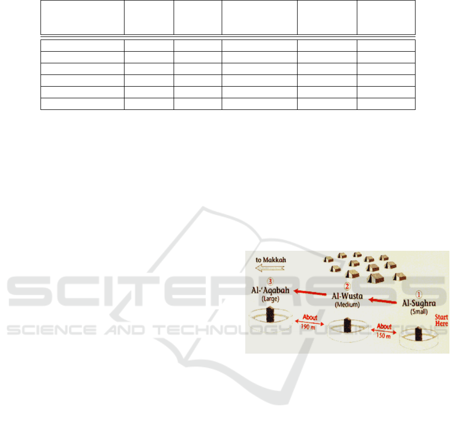
Table 2: Qualitative features of the human mobility models,
Y: Yes, N: No, A: Ambiguous.
Human mobility Realistic Scalable Possibility of a Uses Possibility
models mathematical geographic of
representation map simulation
MhMM Y Y Y Y Y
CMM Y Y Y Y Y
SLAW Y Y N Y Y
TVCM N Y N N Y
SOLAR N Y A N Y
SWIM N Y N N Y
a home location is assigned to each node. And also,
the whole area is partitioned to a number of destina-
tion landmarks which define a weight inversely pro-
portional to the distance between the home location
and the destination and proportional to destination’s
popularity. When a new waypoint is selected by a
node, it moves with a constant speed towards this des-
tination. Once a node visits a landmark, its popularity
is continuously updated according to present nodes at
the same time. When a specific node reaches the tar-
geted location, it waits there for some time and then it
selects a new destination.
The Table 2 shows the qualitative features of the
previous discussed models. All the proposed human
mobility models are often inspired from sociological
movements as for social networks. There are based
on the supposition of depending on their nature of so-
cial communities. In this paper, we present a human
mobility model which is related to Jamarat bridge
to manage movement crowds of pilgrims during the
stoning the devil at the Hajj. The main features and
motivation is presented and analyzed in the next sec-
tion.
3 PROPOSED PATTERN: MINA
HUMAN MOBILITY MODEL
(MhMM)
3.1 Problem Definition and Analysis
Panic stampede is one of the most dramatic collec-
tive attitudes that often causes to the death of peo-
ple who are trampled down or crushed by others.
The diverse collective incident observed in pedestrian
crowds have currently catched the interest of a huge
number of scientists. The real-life implementation
revealed that mostly of the years, some pilgrims die
due to the congestion on throwing the stones (rami al-
jamrat). Some communicated statistics are as follow:
• More than two million of pilgrims per year;
• 20% of pilgrims delegate other pilgrims to do
”rami” instead of them;
• Bridge length is about 600 m;
• Bridge width is about 40 m;
• Number of jamrat is three;
• The distances between the three jamrat are respec-
tively 150 m and 190 m;
• According to religion fixed instructions, the loca-
tions of the three jamrats cannot be shifted.
Figure 5: The three circles of jamarat.
This paper proposes an improved concept of man-
agement and control the pedestrian flow movements
at the Jamarat area in the regular annual pilgrimage to
Hajj season. More than two million of pilgrims ev-
ery year perform their rituals in the midst of a narrow
space and limited time constraint.
3.2 MhMM Concepts
We usually move in our real life depending on geo-
graphic restrictions. That makes our mobility behav-
iors primarily related to obstacles coordinates. More-
over, with a huge number of pedestrians in the same
location, the motion management becomes trickier.
That necessitates a deeper analysis to overcome unex-
pected tragic stampedes and catastrophic crowd disas-
ters. In this case, we need a flexible mobility manage-
ment which will based on real requirements, as the
area size, number of mobile nodes, specific coordi-
nates of zones, needful time, and traveled distance.
Systematic Crowd Mobility Management to Avoid Catastrophic Disasters of Human Stampedes: The Case of Mina Hajj
69
All these mobility features must be related to a realis-
tic conduct of mobile nodes with taking into consid-
eration the historical and spatial dependencies inside
the simulation field. That later allows accurate tra-
jectories to travel from one zone to another with the
most convenient parameters. The proposed model can
modulate pilgrims motions within a specific time pe-
riod and limited space location of the tent city. There-
fore, in this part, we attempt to itemize the various
steps of the new human mobility model entitled Mina
Human Mobility Model (MhMM).
Indeed, each pilgrim is considered as a mobile
node which is identified by a node number, initial co-
ordinates, a speed from a range of 1.5m/s to 5.5m/s,
is attributed to reflect all pedestrians class (fat, tall,
adult, child and old). These nodes are two types: 20%
of total mobile nodes are fixed at zone 1. However,
80% can move to the other zones by selecting a new
position to enter in zone 2 in order to start a move-
ment round. These mobile nodes must travel three
rotations where each one contains five movement de-
cisions to return to the departure position. The same
process must be repeated three times with a bit differ-
ence; the small jamarrat at first tour then the median
at the second afterwards the biggest as the third. Be-
sides that, one day must be between two consecutive
tours namely 86400 seconds is added to the arrival in-
stant of the previous one. The resulted outcomes en-
sue a coherent human mobility model. That owns the
tractability of all nodes which their motion features,
as node identifier, coordinates, speed and time.
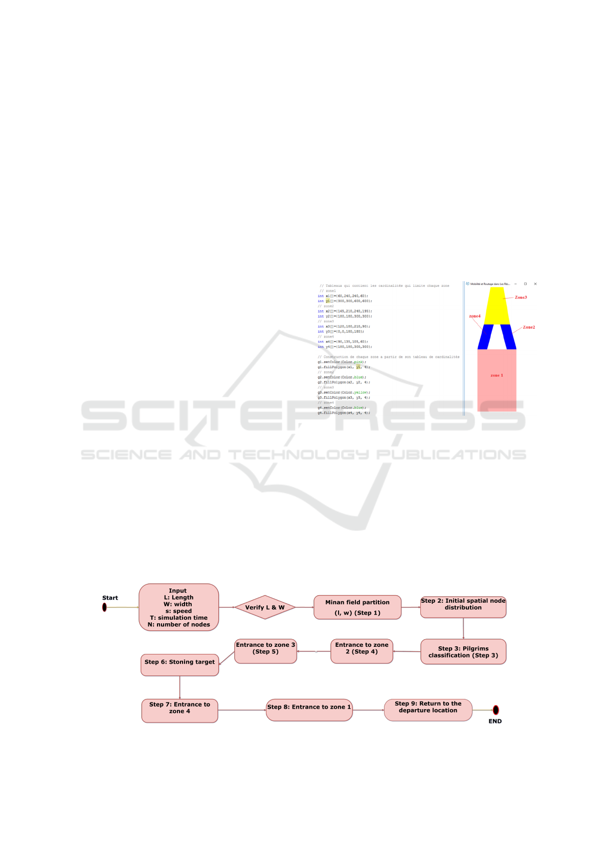
3.3 MhMM Implementation Process
Based on previous features, the implementation of
Mina pattern follows five main steps, as displayed by
the diagram process of Figure 6. The aforementioned
steps are detailed as follows:
Step 1: Mina Field Partition
The creation of Mina area represents the first step
to generate Mina human mobility model. This field is
spread on approximately 20km
2
. In this part, we sug-
gest a new design to improve stoning process from the
tent city to Jamarrat bridges, as shaped in Figure 7.
This area is split to several zones:
• Zone 1 represents the lodging region for mobile
node which reflect the tent area. They must start
and return to this zone after the stoning process.
• Zone 2 is the passage between zones 1 and 3.
• Zone 3 depicts the stoning region with the three
Jamarat bridges that each mobile pilgrims must
reach one bridge at each full round.
• Zone 4 return path to zone 1 after stoning at zone
3.
Figure 7: Mina field partition.
This step is generated once time during all de-
ployment time. The detailed coordinates of the re-
sulted design will be used by all mobile nodes with
the aim to correctly move according to the attributed
geographic restrictions inside this area.
Step 2: Initial Spatial Node Distribution
- Before start moving, we uniformly distribute to-
tal number of pilgrims within the first zone. This pro-
cedure allows each mobile node to own a spatial lo-
cation (xi, yi) that represents its lodging position, as
depicted in Figure 8.
Figure 6: Implementation process of Mina human mobility model (MhMM).
PECCS 2020 - 10th International Conference on Pervasive and Parallel Computing, Communication and Sensors
70
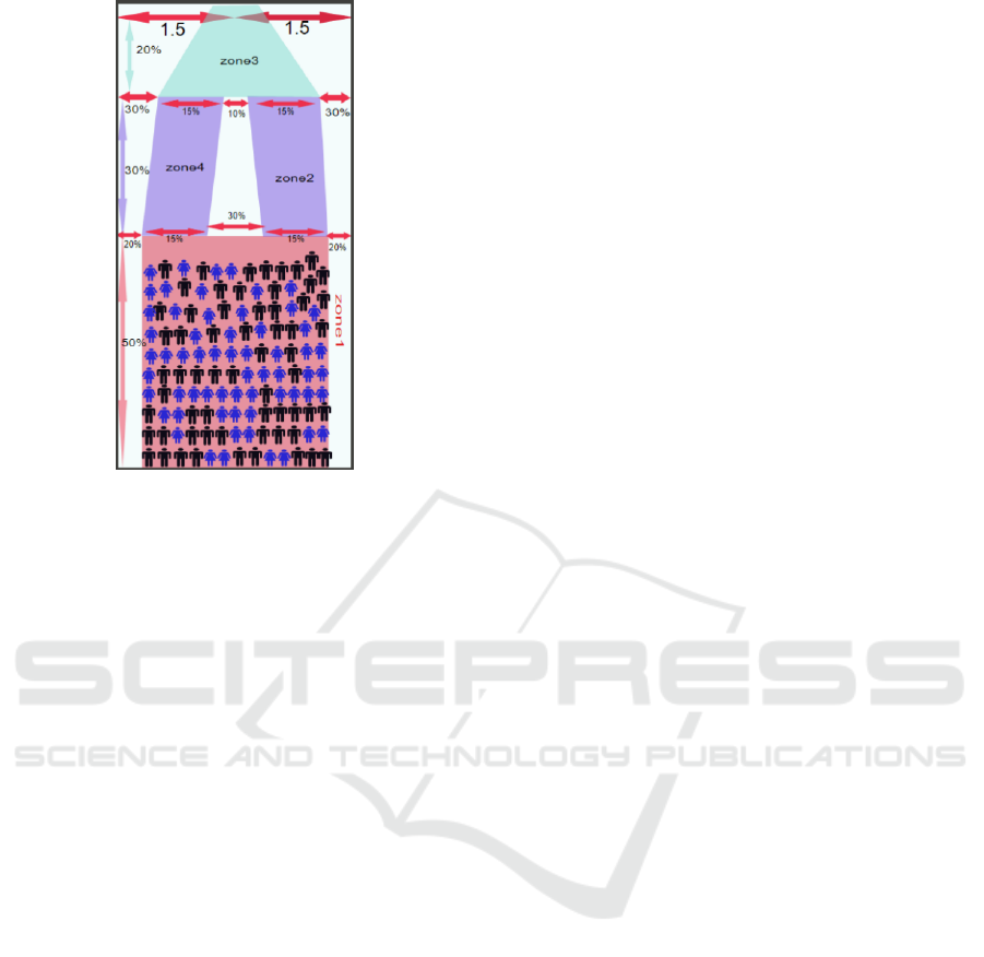
Figure 8: Initial spatial human distribution.
Step 3: Pilgrims Classification
- Due to onerous Hajj activities, Islam allows
only at this ritual to delegate another pilgrim which
is physically capable to throw stones of old people,
sick, or pregnant; for instance. This category is es-
timated as nearby 20% which still fixed during all
three stoning days at zone 1. The other 80% nodes
are marked as mobile where they must access respec-
tively to other zones (2,3, and 4).
Step 4: Entrance to Zone 2
- In order to start moving; at this step, the mobile
node must own an entrance point to the second zone
(x2, y2). These coordinates will be selected based on
the Mina field partition. According to the first step,
the x2 will be randomly selected between [240, 195]
while the y2 will be 300.
- Meanwhile, an assigned speed s(i[n]) must be cho-
sen from a range of [1.5m/s, 5.5 m/s].
- Then; to render this model more realistic, it must
respect motion laws where t = d/s. The distance
D(z1,z2) between the departure point and the entrance
position will be calculated based on the Pythagorean
theorem. That allows to deduce the time needed
t[z1, z2] to travel this calculated distance where T =
D(z1,z2) / s(i[n]).
Step 5: Entrance to Zone 3
- The same process of Step 3 will be done. The
node selects an entrance point to the third zone. The
(x3, y3) will be respectively between [120,180] and
[0,180]. The distance must be calculated to result in
the occupied time t[z2, z3] between (x2, y2) and (x3,
y3). This time will be addition to t[z1, z2] to own the
current T5 with T5 = t[z1, z2] + t[z2, z3].
Step 6: Stoning Target
- This step makes the dissimilarity for the pro-
posed model. Three different stoning targets are avail-
able, the small, the medium and the biggest. Three
cycles must be done for each target at three succes-
sive days.
- For the first turn, the targeted point will be the small
bridge Sb(xs, ys). So, we must result the distance
traveled from (x3, y3) to (xs, ys). Then, the recorded
time T6 which will be added to last T5: T6 = (t[z1,
z2] + t[z2, z3]) + t[z3, zS1]
- The same process will be repeated for the two other
targets; medium and biggest with two other indepen-
dent turns.
Step 7: Entrance to Zone 4
- As the Step 5, we must select an entrance posi-
tion to zone 4 before reaching the stoning target. The
(x4, y4) will be respectively between [90,135] and
[180,300]. The distance must be calculated to result
in the occupied time t[z3, z4] between the stoning po-
sition and (x4, y4). This time will be addition to last
T6 to own the current T7 which equals to T6 + t[z3,
zS1]
Step 8: Entrance to Zone 1
- As the Step 5, we must choose an entrance posi-
tion to zone 1 before reaching the departure location.
The (x41, y41) will be respectively between [105,60]
and [180,300]. The distance must be calculated to re-
sult in the occupied time T8[z4, z41] between (x4, y4)
and (x41, y41). This time will be additionned to last
T7 to own the current T8.
T8 = T7 + t[z4, z41]
Step 9: Return to the Departure Location
- That represents the last movement decision for
each cycle. After several travels, each mobile node
must return to its departure location (x1,y1). The dis-
tance must be calculated to result in the occupied time
t[z41, z1] between the (x41, y41) and (x1, y1). This
time will be additionned to last T6 to own the current
T9 where T9 = T8 + t[z41, z1]
From all these steps are recorded to result in a coher-
ent and realistic synthetic mobility model. Mina hu-
man MM saves for each node three different cycles,
with the difference at ”Step 6”. These movement de-
cisions represent all detailed steps of stoning during
three consecutive days.
4 RESULTS AND DISCUSSION
4.1 Mina Human MM Interpretation
The Mina human MM outputs are saved that record
all movement details that contain pertinent informa-
Systematic Crowd Mobility Management to Avoid Catastrophic Disasters of Human Stampedes: The Case of Mina Hajj
71

tion of mobile nodes at each independent step, as the
departure position, the identifier of pilgrims, motion
duration, speed changing, and so on. This informa-
tion is related each other to result in a coherent mo-
bility pattern from the initial distribution to pilgrims
arrivals. An example of Mina human MM are shown
in Figure 9.
Figure 9: Mina human mobility model generation.
From this capture, we deduce some mobility deci-
sions, as:
• The mobile nodes are stable or mobile, as the real-
life pilgrims classification (Step 3).
• For fixed person, assigned coordinates (X, Y) are
selected at the initial spatial distribution (Step 2),
as defined for nodes 5 and 6 (930, 3700), (960,
4200) respectively.
• For mobile person as for nodes 7 and 8. A set
of mobility parameters are generated to record all
nodes positions during the stoning the devil.
• Each line displays: the time, node identifier, X-
position, Y-position and the selected human speed
from a range (Step 4).
• Several mobility transitions are accomplished to
reach the intended destination. The last line of
each mobile node displays coordinates of the last
location which must be the same with the first po-
sition before moving (Step 2).
• Each mobile pilgrim own 18 mobility decisions
for the three rounds.
4.2 MhMM Features
The human mobility pattern suggested in this paper
owns a set of important features which govern the
whole adopted motion strategy. From all the above-
mentioned steps, we deduce that Mina human MM is
typified by the following features:
• Mina human MM considers the physical laws of
motion by taking into consideration the relation
between distance, time, and speed (Step 4). That
makes this model more realistic.
• It is a time-dependent mobility model: the current
time mainly relies on previous time instants, i.e.,
basically (t = d/s) (Step 5).
• It can be considered a direction-history based
model. It moves according to the last location. So,
it is a spatially dependent mobility model (Step 4).
• The return time and visiting frequency are prob-
abilistically distributed, mainly in relation to the
resulting trajectory (Steps 2 and 4).
• At the initial stage, it has a spatial distribution
only in zone 1. In the subsequent stages, the
resulting trajectory must be constituted only by
authorized zones without any walls or restricted
fields, as shown by Figure 7 (Step 1). This fact
leads a realistic movement behavior that seems
like that in daily-life.
The most important movement features of the
Mina human MM compared to other human mobil-
ity models are highlighted in Table 3. The meaning
of the letters is as follows. C: Constant, UD: Uni-
formly Distributed, HB: History Based, PD: Proba-
bilistically Distributed, PL: Truncated Power-law, P:
Periodic, UD: Uniformly Distributed, NA: Not Appli-
cable.
We conclude that the Mina human MM takes into
consideration a set of realistic movement features to
reflect a real human mobility model. It abides by
the spatial context with several geographic constraints
(Step 1). Mina human MM permits a flexible motion
even if in a limited field, that can be modulated with
diverse constraints. Based on the resulted pattern, pil-
grims can move with the most convient trajectory with
crush preventing (Step 5). That solves the simple ran-
dom process of stoning the devil. It permits an orga-
nized motion which further will be adaptative accord-
ing to pilgrims flow while moving. It exactly reflects
a movement with memory which is mainly inspired
from human motion in real-life. It results in a flexible
and adaptative mobility model which operate in nar-
row areas, even when diverse mobility requirements
are considered.
Thanks to its logical process, its conception, the con-
sideration of real-life movements. These parameters
allow the proposed model more efficient and suitable
even when diverse mobility constraints are presence.
PECCS 2020 - 10th International Conference on Pervasive and Parallel Computing, Communication and Sensors
72
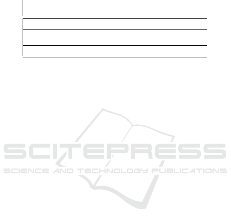
Table 3: Movement features comparison: MhMM vs. other human mobility models.
Mobility Speed Direction Acceleration Pause Flight Return time
models /Deceleration Time Length and Visiting
frequency
MhMM C HB C C/UD C PD
CMM NA PD NA C NA P
SLAW NA PD on set NA TPL TPL P
destinations
TVCM NA PD NA C NA P
SWIM NA UD on set NA C/UD NA P
of locations
5 CONCLUSION
It is important to emulate a real life scenario using a
mobility model. During time, the subject of mobil-
ity modeling have grown where researchers analyze
and suggest new mobility patterns that imitate real
life mobility. The aforementioned factors motivated
us to propose a flexible human mobility model which
is adaptative with the pedestrian’s flow inside the Ja-
marats building. This study suggests multi-solutions
to solve the tragic stampedes and catastrophic crowd
disasters using a simulation program. That uniformly
manage crows by taking into considerations all im-
pacted factors; as the temporal dependencies of previ-
ous movement timing, the spatial dependencies of the
current position foremost depends on the last location.
Meanwhile, geographic restrictions inside the ston-
ing area are considered. Mina human MM acquires
strengths from these realistic combinations. The ben-
efits of this study encourage adopting this solution.
As future works, the Ministry of Municipal and Ru-
ral Affairs in Saudi Arabia must adopt this scheduling
program to register pilgrims to get a timetable and an
assigned route to distribute them uniformly in the dif-
ferent Jamarat building levels. Awareness and guid-
ance for pilgrims are embedded.
REFERENCES
Batabyal, S. and Bhaumik, P. (2015). Mobility models,
traces and impact of mobility on opportunistic routing
algorithms: A survey. IEEE Communications Surveys
& Tutorials, 17(3):1679–1707.
Girvan, M. and Newman, M. E. (2001). Community struc-
ture in social and biological networks. Proc. Natl.
Acad. Sci. USA, 99(cond-mat/0112110):8271–8276.
Ibadah, N., Minaoui, K., Rziza, M., Oumsis, M., and
Benavente-Peces, C. (2018). Deep validation of spa-
tial temporal features of synthetic mobility models.
Computers, 7(4):71.
Jeon, S., Figueiredo, S., Aguiar, R. L., and Choo, H. (2017).
Distributed mobility management for the future mo-
bile networks: A comprehensive analysis of key de-
sign options. IEEE Access, 5:11423–11436.
Mei, A. and Stefa, J. (2009). Swim: A simple model to
generate small mobile worlds. In IEEE INFOCOM
2009, pages 2106–2113. IEEE.
Trifunovic, S., Kouyoumdjieva, S. T., Distl, B., Pajevic, L.,
Karlsson, G., and Plattner, B. (2017). A decade of
research in opportunistic networks: challenges, rele-
vance, and future directions. IEEE Communications
Magazine, 55(1):168–173.
Wang, K., Huang, G., Shu, L., Zhu, C., and He, L. (2015).
A social awareness based feedback mechanism for de-
livery reliability in delay tolerant networks. In 2015
IEEE International Conference on Communications
(ICC), pages 7007–7011. IEEE.
Systematic Crowd Mobility Management to Avoid Catastrophic Disasters of Human Stampedes: The Case of Mina Hajj
73
