
Dense Semantic Stereo Labelling Architecture for In-Campus Navigation
Jorge Beltr
´
an, Carlos Jaraquemada, Basam Musleh, Arturo de la Escalera and Jose Mar
´
ıa Armingol
Intelligent Systems Lab (LSI) Research Group, Universidad Carlos III de Madrid (UC3M), Legan
´
es, Madrid, Spain
jbeltran@ing.uc3m.es, carlosborja.jaraquemada@uc3m.es, {bmusleh, escalera, armingol}@ing.uc3m.es
Keywords:
Dense Labelling, Semantic Labelling, Stereo Vision, Off-road Navigation, ROS.
Abstract:
Interest on autonomous vehicles has rapidly increased in the last few years, due to recent advances in the
field and the appearance of semi-autonomous solutions in the market. In order to reach fully autonomous
navigation, a precise understanding of the vehicle surroundings is required. This paper presents a novel ROS-
based architecture for stereo-vision-based semantic scene labelling. The objective is to provide the necessary
information to a path planner in order to perform autonomous navigation around the university campus. The
output of the algorithm contains the classification of the obstacles in the scene into four different categories:
traversable areas, garden, static obstacles, and pedestrians. Validation of the labelling method is accomplished
by means of a hand-labelled ground truth, generated from a stereo sequence captured in the university campus.
The experimental results show the high performance of the proposed approach.
1 INTRODUCTION
The interest on autonomous vehicles has undergone
a significant growth in the last 10 years due to its
rapid development and the arrival of the first semi-
autonomous commercial solutions. As a conse-
quence, both companies and the university commu-
nity are putting much effort into doing research in this
field driven by its potential advantages in a wide num-
ber of areas like traffic management, road safety or
disabled-passengers mobility.
However, this upcoming horizon may require
dealing with complex tasks such as localization, nav-
igation or inter-vehicle cooperation, depending on the
vehicle desired level of automation.
A standardized scale for automation degrees is the
SAE International’s table (SAE On-Road Automated
Vehicle Standards Committee, 2014). It describes the
different automation levels which range from 0 (no
automation) to 5 (full automation). A human driver
is considered to be in charge of monitoring the envi-
ronment in the first three levels. The big turning point
comes at level 3 (Conditional Automation), where the
system progressively replaces the driver intervention
as the automation level increases. Therefore, one of
the main challenges for automation involves acquir-
ing a detailed knowledge of the vehicle surroundings.
There are several methods for environment infor-
mation retrieval based on the kind of used sensor. On
the one hand, those based on laser (Urmson et al.,
Figure 1: Autonomous vehicle iCab.
2008) (Broggi et al., 2008) obtain very high precision
data although they only provide distance information.
Therefore, these approaches are usually suitable for
detection tasks and map generation. On the contrary,
they don’t provide enough information from the envi-
ronment to classify the different scene elements.
On the other hand, computer vision based sys-
tems obtain rich information of the vehicle surround-
ings at the expense of less precise distance measure-
ments. Concretely, stereo vision systems allow depth
estimation for all pixels in the image by computing
the disparity map. After this process, the uv-disparity
maps (Labayrade and Aubert, 2003) (Hu et al., 2005)
can be obtained so that it can be used to detect both
266
Beltrà ˛an J., Jaraquemada C., Musleh B., De La Escalera A. and Armingol J.
Dense Semantic Stereo Labelling Architecture for In-Campus Navigation.
DOI: 10.5220/0006131602660273
In Proceedings of the 12th International Joint Conference on Computer Vision, Imaging and Computer Graphics Theory and Applications (VISIGRAPP 2017), pages 266-273
ISBN: 978-989-758-226-4
Copyright
c
2017 by SCITEPRESS – Science and Technology Publications, Lda. All rights reserved
obstacles and free space within the scene (Bernini
et al., 2014), thus obtaining the so-called obstacles
map and free map (Soquet et al., 2007) (Guo et al.,
2009) (Musleh et al., 2011). In addition, there are
also many related works providing a more advanced
scene labelling, both for urban (Sengupta et al., 2012)
(Sengupta et al., 2013) (Long et al., 2015) and indoor
environments (Golodetz et al., 2015).
Apart from stereo rigs, monocular lenses are also
commonly used for scene understanding. Despite the
handicap of not having precise depth information out-
of-the-box, they are very suitable for classification
tasks as they provide rich information at low cost.
In contrast with stereo approaches, monocular al-
gorithms for scene classification and labelling does
not rely on previously segmented Regions of Interest
(ROIs) (Yao et al., 2012) (Mottaghi et al., 2014) (Ren
et al., 2015) (Arnab et al., 2016).
However, two main downsides are present in most
of the methods mentioned above: the high hardware
specifications requirements to guarantee real-time ex-
ecution, as in deep learning approaches, as well as
the need of massive datasets for training classifiers.
Regarding the availability issue of datasets, many re-
search laboratories are publicly releasing their own,
so there already exist some large annotated datasets
for scene labelling (Cordts et al., 2016).
Nevertheless, both the need of task-specific
datasets and the time required in annotation process
represent a bottleneck for widening the application
scope of this technology. As a result, recent work
(Richter et al., 2016) is taking advantage of video-
games calls to GPU interface to fetch labels for pix-
els of the different objects in the scene, so that la-
belling stage can be partially automated in order to
easily build large datasets.
The main contribution of this work is a ROS-based
architecture for dense image labelling able to obtain
rich understanding of vehicle surroundings for au-
tonomous navigation tasks. The presented approach
takes advantage of stereo information for scene seg-
mentation. The organization of the algorithm into
loosely coupled stages provides the proposed archi-
tecture with the capability of being extended with ease
so that other classifiers can be easily integrated.
The rest of the paper is organized as follows. Next
section, focuses on the architecture description. Sec-
tion 3 gives a description of the proposed algorithm.
Afterwards, Section 4 presents a novel database for
algorithm validation and a detailed description of the
experimental results. Finally in Section 5, conclu-
sions and future work are presented.
2 ARCHITECTURE DESIGN
The proposed architecture has been designed to run
in our research platform called iCab (Hussein et al.,
2016), a vehicle for autonomous in-campus naviga-
tion (see Fig. 1). Therefore, it has been fully inte-
grated with the iCab framework previously developed
by the authors (Marın-Plaza et al., 2016). As a result,
the architecture is built on top of ROS (Robot Operat-
ing System) (Garage, 2010).
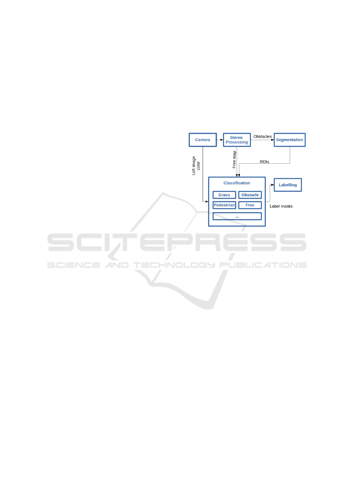
Figure 2: Architecture scheme.
The architecture scheme presented in this work is
shown in Fig 2. As can be observed, it is composed by
5 different nodes corresponding to each of the stages
of the algorithm. First of all, in the acquisition stage
(camera), images are captured from the sensors both
in colour and gray-scale. Afterwards, the stereo pro-
cessing node receives the synchronized stereo images
and builds the disparity map. Therefore depth infor-
mation can be retrieved. Then, uv-disparity maps are
computed so that they can be used for calculating the
obstacle and free map. Later, segmentation stage sep-
arates the different obstacles present in its input map
into ROIs based on their disparity information. In
classification phase, different classifiers make use of
the previously generated images and ROIs in order to
determine the class which each pixel belongs to, thus
producing per-class masks. Finally, at the labelling
stage the produced masks are fused in order to obtain
the final label of the pixels.
3 ALGORITHM
The algorithm for dense semantic stereo labelling in-
troduced in this paper is based on different methods of
computer vision. A large proportion of the algorithm
uses the stereo information in order to detect the ob-
Dense Semantic Stereo Labelling Architecture for In-Campus Navigation
267

stacles and the free space in front of the vehicle (Sec-
tion 3.1), whereas the visible information is used to
classify obstacles as pedestrians and non-traversable
areas, such as gardens (Section 3.3). The different
stages of the proposed algorithm will be explained in
this section.
3.1 Obstacle and Free Space Estimation
As commented above, the stereo images supplied by
the vision system can be used in order to obtain 3D
information of the vehicle’s environment. This 3D in-
formation is usually represented by the disparity map
(see Fig. 3a), where the value of the each pixel is pro-
portional to its depth. An useful method to depict the
stereo information of the vehicle’s environment is the
uv-disparity which is obtained from the disparity map
(Hu and Uchimura, 2005). The uv-disparity contains
information of the location both of the obstacles and
ground ahead the vehicle; being able to distinguish
between them. A previous work (Musleh et al., 2011)
is then used to separate the disparity map into to dif-
ferent disparity maps: the obstacle map (see Fig. 3c),
which contains the pixels belonging to the obstacles,
and the free map (see Fig. 3d), which contains the
pixels of the ground.
3.2 Pedestrian Classification
The university campus environment contains different
kind of areas and obstacles (buildings, trees, lamp-
post pedestrians, garden, etc.) that have to be avoided
while navigating. A basic classification for in-campus
navigation requires at least identifying garden areas
and dynamic obstacles, mainly pedestrians.
In the approach presented in this paper, obstacle
classification is based on the determination of Re-
gions of Interest in the visible image (Llorca et al.,
2012). These ROIs isolate obstacles so that they
can be processed by classifiers in subsequent stages.
However, due to the characteristics of the campus en-
vironment, most of the obstacles arise in the prox-
imity of the vehicle, so obstacles may be fragmented
into different ROIs as they may get different disparity
values due to high depth precision in the short dis-
tance, making classification process much harder. To
address this issue, an algorithm for ROI grouping has
been designed. Looking at the u-disparity map, ob-
stacles are represented as continuous blobs in white.
These blobs are analysed to compute the maximum
and minimum disparity levels as well as the max and
min horizontal coordinates of each obstacle. After-
wards, both depth and width data is used to group
previously computed ROIs, therefore fixing obstacle
fragmentation issue.
Once ROIs have been computed for each obstacle
in the image, a HOG classifier is used to determine the
probability of each region to be a pedestrian. In case
of a positive classification, obstacle map is threshed to
get a binary mask of the pixels within the previously
obtained region’s disparity range. Finally, pixels of
the mask inside the ROI area are labelled as pedestri-
ans.
This architecture design, where segmentation
and classification stages are loosely coupled, makes
it possible to use different classifiers for multiple
classes and thus, provides great versatility.
3.3 Determination of Traversable Areas
Taking the free map as the starting point, backpro-
jection algorithm is used to obtain the probability of a
pixel belonging to garden class. For this stage, the vis-
ible image is converted into HSV colour-space as this
kind of colour representation is more robust against
light condition changes than RGB. After the conver-
sion is performed, a synthetic histogram is built en-
compassing the HUE range corresponding to green
values usually taken by garden areas. Then, it is used
as input to the backprojection algorithm.
Once the probabilities of belonging to garden
class are obtained, an empirically tuned threshold is
used to label pixels as garden or traversable area.
4 RESULTS
In order to test the performance of the proposed
method for dense image labelling, an annotated
database is used. Since the research platform is
aimed to navigate inside the university campus area
in harmony with the university community, a spe-
cific ground truth is required for evaluation. Thus,
a novel database (Beltr
´
an et al., 2016) has been gen-
erated considering the particular needs for this task.
4.1 Dataset Description
The developed dataset is composed of a set of 30
manually-annotated images with a 640x480 resolu-
tion (see Fig. 4). Frames are captured by a Bumble-
bee 2 stereo rig sensor with a focal length of 6mm, a
baseline of 0.12m, and a HFOV angle of 43
◦
. The
camera is mounted on the forepart of the iCab re-
search platform. The small resolution of the dataset is
due to the actual restrictions of the platform: limited
computing resources as well as the demanding com-
puting times required by real-time applications, like
VISAPP 2017 - International Conference on Computer Vision Theory and Applications
268
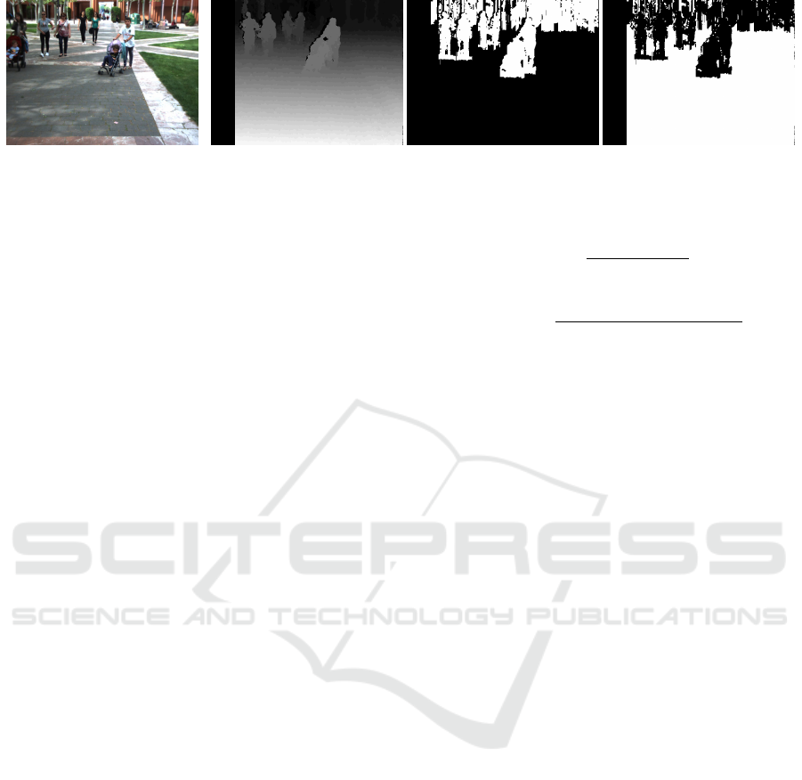
(a) Visible image. (b) Disparity map. (c) Obstacle map. (d) Free map.
Figure 3: Example of the obstacle and ground estimation.
navigation in unstructured environments such as the
University campus.
All images in the collection are part of a single se-
quence recorded by the iCab moving around the Uni-
versity campus. The original video rate is 20 fps with
a total length of 60 seconds. However, although the
labelling algorithm is working in real-time, only one
out of every 40 frames of the video is used for perfor-
mance evaluation.
Four different classes are used for labelling the
dataset. The chosen categories correspond to the
most popular instances found around the Univer-
sity campus and compose the minimum set re-
quired for in-campus navigation. The four categories
are: traversable area, garden, obstacles and pedes-
trian. Segmentation and classification of the selected
classes provide the necessary knowledge about the
platform surroundings in order to detect traversable
areas avoiding collision with static obstacles such as
buildings and urban furniture and most common dy-
namic obstacles like pedestrians, being able to guar-
antee that the platform will not navigate over green
areas and parks.
The selected dataset is publicly accessible and is
composed of two sets of images: the original pair
of colour images and their corresponding annotated
ground truth containing the labels for the aforemen-
tioned classes. Fig. 4 shows an example of an origi-
nal image and its annotations from the dataset. As can
be observed, the ground truth is made up of one fully
annotated RGB image .png for each original frame
where each pixel takes the colour associated to the
category it belongs to: traversable area in blue, gar-
den in green, obstacles in red and pedestrian in yel-
low. Additionally, unknown pixels will be assigned
black colour during classification stage.
4.2 Metrics
The computer used to perform the experiments to
assess the performance of the proposed labelling
method is an on-board embedded computer having an
Intel Core i7 processor with 8 cores at 4.0 GHz and
16 GB RAM. All developed algorithms are running
over ROS Kinetic on an Ubuntu 16.04 environment.
ACC =
T P
num. of pixels
(1)
IoU
class
=
T P
class
T P
class
+ FP
class
+ FN
class
(2)
In order to assess the per-pixel semantic labelling
performance of our method two different metrics are
used. On the one hand, the global accuracy of the al-
gorithm is measured as in (1), allowing to determine
the proportion of properly-classified pixels. On the
other hand, for the purpose of identifying the per-class
classification accuracy, the Jaccard Index, commonly
known as PASCAL VOC intersection-over-union, is
used. The Jaccard Index is computed as in (2), where
TP, FP, and FN stand for true positive, false posi-
tive and false negative pixels, respectively. The re-
ported results correspond to the mean performance
computed over the whole set of images.
In order to measure the suitability of our method
for the task of real-time image labelling for au-
tonomous navigation, two well-known disparity al-
gorithms are tested. Thus, it is possible to compare
which one provides the best trade-off between per-
pixel accuracy and computation time, provided that
our method strongly relies on the quality of the dis-
parity map at its first stages. The disparity meth-
ods considered in our experiments are Block Match-
ing (BM) and Semi Global Block Matching (SGBM)
(Hirschmuller, 2008).
4.3 Experimental Results
The results of applying our labelling algorithm to the
dataset images are collected in Table 1 (see Fig. 5).
As can be observed, there are no significant differ-
ences between the results of the two disparity meth-
ods, being the SGBM slightly more accurate in both
per-pixel and per-class classification. These findings
meet the expected outcomes provided that the semi-
global algorithm take into account a greater amount
of information in order to compute the depth estima-
tion of each of the pixels.
Dense Semantic Stereo Labelling Architecture for In-Campus Navigation
269
Table 1: Four-classes classification performance (%).
Disparity Pixel-wise IoU
class
Method Accuracy Free Garden Obstacle Pedestrian
BM 86.81 87.42 69.01 66.41 47.05
SGBM 87.79 88.34 70.31 67.75 43.43
(a) (b)
(c) (d)
Figure 4: Image - Ground truth pair from dataset a) and
c) Visible images. b) and d) Labelled ground truth. Best
viewed in colour.
Despite of the minor differences, the proposed
method behaves similarly for each of the selected
metrics independently of the chosen disparity algo-
rithm, thus indicating an existing trend in terms of
per-pixel accuracy and per-class classification. Tak-
ing into consideration the results provided for each of
the existing classes, it can be observed that there is an
important difference between traversable area classi-
fication and the other categories. This is explained by
the fact that the stereo sensor provides better depth
estimation in the nearest environment as the textures
are sharper. Thus, pixels corresponding to the areas
which are closer to the camera will be more likely to
get its disparity properly computed. Consequently, as
the area in front of the vehicle is usually ground, best
classification corresponds to traversable category. As
a result, pixels belonging to obstacles usually lay on
farther areas and tend to be more likely misclassified.
The performance of the garden classifier behaves
as expected. As it is based on ground detection, its
results are bounded by the free map segmentation
phase. Moreover, garden recognition through back-
projection (Swain and Ballard, 1992) algorithm is
only based on HUE channel, therefore suffering from
drastic contrast or light changes in the scene.
Finally, pedestrian classifier provides the worst
per-class classification output. This situation is a con-
sequence of using a standard HOG classifier from
external libraries, which is not adjusting well to
multi-scale classification and does not work on semi-
occluded persons that may appear at the edges of the
images or cropped at the segmentation phase. These
issues can be observed in detail in Fig. 6.
Regarding the overall per-pixel accuracy, the al-
gorithm labels properly more than 85% of the pixels
in each frame, overcoming by far the average IoU
class
and getting really close to the best classified category,
as it makes up most of the pixels in the sequence.
Table 2: Three-classes classification performance (%).
Disparity Pixel IoU
class
Method Accuracy Free Garden Obst.
BM 88.35 87.42 69.01 72.31
SGBM 89.53 88.34 70.31 74.74
For the purpose of analysing the effect of the
pedestrian classification results in the method accu-
racy, an experiment has been carried out considering
only the other three categories. Table 2 comprises the
performance of the proposed method for this case. As
can be observed, both the IoU
obstacle
and the overall
accuracy get higher, being more significant the ob-
stacle class increment. These variations shows how
much pedestrian classifier deteriorates overall accu-
racy. Furthermore, the big growth in obstacle classifi-
cation performance indicates that not only the classi-
fier produces many false positive and false negatives,
but also that some pixels labelled as pedestrian, re-
ally belong to obstacle category. However, as they are
wrongly grouped as part of the person shape in the
segmentation phase, they end up being considered as
part of the pedestrian class.
Considering traversable and garden categories,
they both provides the same performance as in the
4-class case, as long as they are not affected by the
pedestrian classifier.
4.4 Computational Time
As time is a key factor in real-time algorithms, mea-
sured times for the performed experiments are pre-
sented in Table 3 for the purpose of determining
which configuration is more suitable for the task of
scene labelling for autonomous navigation.
As can be appreciated, the Block Matching al-
gorithm is considerably less time consuming than
VISAPP 2017 - International Conference on Computer Vision Theory and Applications
270
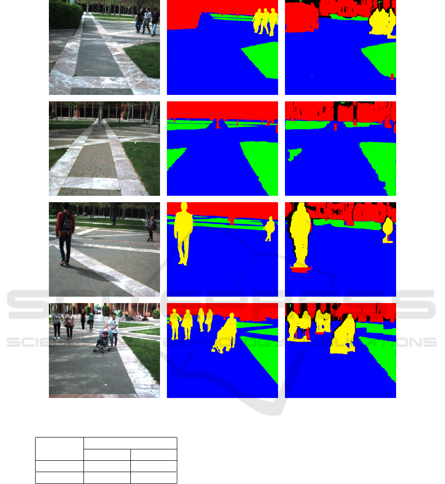
Figure 5: Labelling results. From left to right: visible image, ground truth and labelled image. Best viewed in colour.
Table 3: Computing times (ms).
Disparity # Classes
Method 4 classes 3 classes
BM 120.75 65.10
SGBM 187.98 134.32
SGBM at the expense of depth estimation accuracy.
In addition, there is a big difference between 4 and
3-class cases, indicating that pedestrian classifier is
not only the worst at performance, but also one of
most time costly. However, taking into consideration
both the real-time requirements and the perception
needs for in-campus navigation task, it can be asserted
that the best configuration for the proposed method is
composed of Block Matching disparity method and 4-
class classifier, as long as it gives the best trade-off be-
tween the labelling accuracy and the needed operating
frame rate, since camera images come at 20Hz and
labelled images are available at 16Hz due to parallel
processing. Therefore, this setup is suitable to work in
real-time on the described platform since iCab’s top
speed is 10km/h, thus covering 0.18m between two
consecutive frames when driving at maximum speed.
5 CONCLUSIONS
Environment understanding plays a key role in any
autonomous navigation task. Therefore, being able to
classify the information obtained from sensors such
as cameras and lasers is essential for the process
of generating a reliable map that allows path plan-
ning. The main contribution of this paper is to pro-
vide an algorithm for dense scene labelling tested on
Dense Semantic Stereo Labelling Architecture for In-Campus Navigation
271
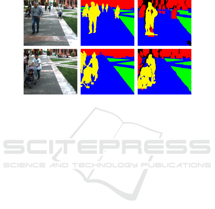
Figure 6: Labelling issues. From left to right: visible image, ground truth and labelled image. Best viewed in colour.
off-road environments based on a flexible and decou-
pled architecture built on ROS. Moreover, a novel
manually-annotated dataset is presented for evalua-
tion purposes.
The results of the proposed approach show a high
performance at labelling in-campus scenarios. This
accuracy, together with the low computational times,
make the introduced algorithm a suitable and efficient
solution for dense image classification within the en-
vironment under research.
In addition, the modularity of the proposed archi-
tecture provides the ability to adapt the algorithm to
work well for other environments. The highly de-
coupled design gives the possibility of extending the
number of categories by adding other classifiers in a
plug-and-play manner. Similarly, the existing mod-
ules can be easily upgraded or replaced by new ones
which might grant better performance.
In the future, pedestrian classifier will be replaced
by a more advanced algorithm with better capabilities
for multi-scale classification. Moreover, garden clas-
sifier will be tuned to combine information from all
three channels (H, S and V) to improve results.
Finally, the released database will be extended
with images from other sequences as well as non-
used images of the actual video. In addition, database
might be re-annotated to include more classes in or-
der to achieve a better understanding of the vehicle
surroundings.
ACKNOWLEDGEMENTS
This work was supported by the Spanish Govern-
ment through the CICYTprojects (TRA2013-48314-
C3-1-R and TRA2015-63708-R) and Comunidad de
Madrid through SEGVAUTO-TRIES (S2013/MIT-
2713).
REFERENCES
Arnab, A., Jayasumana, S., Zheng, S., and Torr, P. H.
(2016). Higher order conditional random fields in
deep neural networks. In European Conference on
Computer Vision, pages 524–540. Springer.
Beltr
´
an, J., Jaraquemada, C., Musleh, B., de la Escalera,
A., and Armingol, J. M. (2016). SAUCE, Semantic
Annotated University Campus Environment. Dataset.
http://dx.doi.org/10.5281/ZENODO.167843.
Bernini, N., Bertozzi, M., Castangia, L., Patander, M.,
and Sabbatelli, M. (2014). Real-time obstacle detec-
tion using stereo vision for autonomous ground vehi-
cles: A survey. In Intelligent Transportation Systems
(ITSC), 2014 IEEE 17th International Conference on,
pages 873–878. IEEE.
Broggi, A., Cappalunga, A., Caraffi, C., Cattani, S., Ghi-
doni, S., Grisleri, P., Porta, P., Posterli, M., Zani, P.,
and Beck, J. (2008). The passive sensing suite of the
terramax autonomous vehicle. In Intelligent Vehicles
Symposium, 2008 IEEE, pages 769–774. IEEE.
Cordts, M., Omran, M., Ramos, S., Rehfeld, T., Enzweiler,
M., Benenson, R., Franke, U., Roth, S., and Schiele,
B. (2016). The cityscapes dataset for semantic urban
scene understanding. In Proc. of the IEEE Conference
on Computer Vision and Pattern Recognition (CVPR).
VISAPP 2017 - International Conference on Computer Vision Theory and Applications
272

Garage, W. (2010). Ros. ros. org.
Golodetz, S., Sapienza, M., Valentin, J. P., Vineet, V.,
Cheng, M.-M., Arnab, A., Prisacariu, V. A., K
¨
ahler,
O., Ren, C. Y., Murray, D. W., et al. (2015). Seman-
ticpaint: A framework for the interactive segmentation
of 3d scenes. arXiv preprint arXiv:1510.03727.
Guo, C., Mita, S., and McAllester, D. (2009). Drivable road
region detection using homography estimation and ef-
ficient belief propagation with coordinate descent op-
timization. In Intelligent Vehicles Symposium, 2009
IEEE, pages 317–323. IEEE.
Hirschmuller, H. (2008). Stereo processing by semiglobal
matching and mutual information. IEEE Transac-
tions on pattern analysis and machine intelligence,
30(2):328–341.
Hu, Z., Lamosa, F., and Uchimura, K. (2005). A complete
uv-disparity study for stereovision based 3d driving
environment analysis. In 3-D Digital Imaging and
Modeling, 2005. 3DIM 2005. Fifth International Con-
ference on, pages 204–211. IEEE.
Hu, Z. and Uchimura, K. (2005). Uv-disparity: an effi-
cient algorithm for stereovision based scene analysis.
In IEEE Proceedings. Intelligent Vehicles Symposium,
2005., pages 48–54. IEEE.
Hussein, A., Mar
´
ın-Plaza, P., Mart
´
ın, D., de la Escalera, A.,
and Armingol, J. M. (2016). Autonomous off-road
navigation using stereo-vision and laser-rangefinder
fusion for outdoor obstacles detection. In Intelligent
Vehicles Symposium (IV), 2016 IEEE, pages 104–109.
IEEE.
Labayrade, R. and Aubert, D. (2003). In-vehicle obstacles
detection and characterization by stereovision. Proc.
IEEE In-Vehicle Cognitive Comput. Vis. Syst, pages
1–3.
Llorca, D., Sotelo, M., Hell
´
ın, A., Orellana, A., Gavil
´
an,
M., Daza, I., and Lorente, A. (2012). Stereo regions-
of-interest selection for pedestrian protection: A sur-
vey. Transportation research part C: emerging tech-
nologies, 25:226–237.
Long, J., Shelhamer, E., and Darrell, T. (2015). Fully con-
volutional networks for semantic segmentation. In
Proceedings of the IEEE Conference on Computer Vi-
sion and Pattern Recognition, pages 3431–3440.
Marın-Plaza, P., Beltr
´
an, J., Hussein, A., Musleh, B.,
Martın, D., de la Escalera, A., and Armingol, J. M.
(2016). Stereo vision-based local occupancy grid map
for autonomous navigation in ros.
Mottaghi, R., Chen, X., Liu, X., Cho, N.-G., Lee, S.-W.,
Fidler, S., Urtasun, R., and Yuille, A. (2014). The
role of context for object detection and semantic seg-
mentation in the wild. In The IEEE Conference on
Computer Vision and Pattern Recognition (CVPR).
Musleh, B., de la Escalera, A., and Armingol, J. M. (2011).
Uv disparity analysis in urban environments. In In-
ternational Conference on Computer Aided Systems
Theory, pages 426–432. Springer Berlin Heidelberg.
Ren, S., He, K., Girshick, R., and Sun, J. (2015). Faster
r-cnn: Towards real-time object detection with region
proposal networks. In Advances in neural information
processing systems, pages 91–99.
Richter, S. R., Vineet, V., Roth, S., and Koltun, V. (2016).
Playing for data: Ground truth from computer games.
arXiv preprint arXiv:1608.02192.
SAE On-Road Automated Vehicle Standards Committee
(2014). Taxonomy and definitions for terms related
to on-road motor vehicle automated driving systems.
Sengupta, S., Greveson, E., Shahrokni, A., and Torr, P. H.
(2013). Urban 3d semantic modelling using stereo
vision. In 2013 IEEE International Conference on
Robotics and Automation. IEEE.
Sengupta, S., Sturgess, P., Torr, P. H., et al. (2012). Au-
tomatic dense visual semantic mapping from street-
level imagery. In 2012 IEEE/RSJ International Con-
ference on Intelligent Robots and Systems, pages 857–
862. IEEE.
Soquet, N., Perrollaz, M., Labayrade, R., Aubert, D., et al.
(2007). Free space estimation for autonomous navi-
gation. In 5th International Conference on Computer
Vision Systems.
Swain, M. J. and Ballard, D. H. (1992). Indexing via color
histograms. In Active Perception and Robot Vision,
pages 261–273. Springer.
Urmson, C., Anhalt, J., Bagnell, D., Baker, C., Bittner, R.,
Clark, M., Dolan, J., Duggins, D., Galatali, T., Geyer,
C., et al. (2008). Autonomous driving in urban envi-
ronments: Boss and the urban challenge. Journal of
Field Robotics, 25(8):425–466.
Yao, J., Fidler, S., and Urtasun, R. (2012). Describing the
scene as a whole: Joint object detection, scene clas-
sification and semantic segmentation. In Computer
Vision and Pattern Recognition (CVPR), 2012 IEEE
Conference on, pages 702–709. IEEE.
Dense Semantic Stereo Labelling Architecture for In-Campus Navigation
273
