
A MapReduce based Big-data Framework for Object Extraction
from Mosaic Satellite Images
Süleyman Eken and Ahmet Sayar
Department of Computer Engineering, Kocaeli University, Kocaeli, Turkey
1 RESEARCH PROBLEM
Earth observation satellites survey the earth by
taking pictures along their pre-defined orbit, and
send those pictures to ground stations. After having
completed their rotations around the earth they
create a set of pictures defining and depicting earth’s
surface. The pictures satellites take are called tiles or
mosaics. Most of the time mosaics cannot represent
objects as a whole, and they need to be stitched to
get a picture of a specific object. Stitching of
satellite mosaics is used in many science domains
such as remote sensing, geomatics, information
science, geophysics, map engineering and
cartography, and in many application areas such as
object recognition/extraction/tracing, spatial
analysis, topologic analysis, civil and military
simulation applications, augmented reality
applications etc. (Dawn et al, 2010).
When vision of the various parts of the same
object falls in different mosaics, they need to be
stitched together in order to obtain that object in one
picture. This is inevitable in the applications of
object recognition and extraction. As a real world
example, to get Island of Cyprus in one picture by
using LandSat-8 satellite mosaics, we need four
mosaics to be stitched together to form a whole
picture of Cyprus. For some other objects, we might
need to stitch tens or even hundreds of mosaics. As
the number and sizes of the mosaics to be stitched
increases, the computation resources needed, such as
CPU and memory, increases exponentially. This
makes stitching in only one computer harder or even
impossible (Sayar et al, 2014). In central
computations, we not only have resource shortage
and poor performance problems but also some other
problems stemming from the spatio-temporal
characteristics of satellite images. That is, partially
overlapping satellite images (mosaics) might be
taken at different times (temporal) for the same
location. This might cause misleading pixel values
for the same object scattered on different mosaics,
and as a result failure in image stitching and object
extraction (Sayar et al, 2013). In addition, it is not
possible to determine the boundaries of an object
presented as a satellite image. Extraction of lakes
and islands might be easy. However, rivers, roads,
and some other user defined objects are impossible
to extract with full automatic systems (Eken and
Sayar, 2015a).
Aforementioned problems can be classified into
two groups. These are (1) resource and performance
problems in central computation, i.e. single machine,
for stitching mosaics to extract an object and (2)
defining both boundaries of an object and
corresponding mosaics on a satellite image. For the
second problem, we propose a heuristic approach
based on user interactions with reference maps.
Boundaries of an object are roughly defined by
users’ mouse actions. Fine-grained boundaries are
calculated automatically by the program itself.
Regarding resource and performance problems, we
propose a distributed big data framework based on
MapReduce approach to enable scalable and high
performance image stitching and object extraction.
2 OUTLINE OF OBJECTIVES
With the rapid development of satellite technologies,
satellite images have been used in a variety of
purposes more effectively. In this work, we aim to
stitch satellite tiles into one exact image and extract
interested objects from it by means of proposed
distributed big data framework based on MapReduce
programming paradigm.
Processing satellite images is harder than
processing any other images. Due to the satellite
images consist of spatio-temporal data, image
stitching is even harder with pixel based methods
which are sensitive to the intensity changes,
introduced for instance by noise, varying
illumination. So, the success rates of these methods
are low.
Moreover, image stitching usually requires
remarkable computational capabilities for large scale
applications (Mamta et al, 2013). In short, remote
14
Eken, S. and Sayar, A.
A MapReduce based Big-data Framework for Object Extraction from Mosaic Satellite Images.
In Doctoral Consortium (DCIT 2016), pages 14-18

sensing (RS) image stitching is data and
computation intensive task (Lajiao et al, 2015).
Some works have been done to stitch RS images in
parallel computing paradigm. They are presented in
more detail in section 3. Spite of these works,
handling large scale images and conducting the
parallel programming logic are still serious issues. In
this manner, we will be solved large scale RS image
stitching with vector representations of the raster RS
images. It is expected to give better performance in
distributed computations by reducing the negative
effects of bandwidth problem. The feasibility and
high performance test of the proposed framework
will be tested on real satellite images of real objects.
It is planned to achieve the following objectives
with our framework enabling scalable and high
performance image stitching and object extraction:
Identifying the object boundaries using a
heuristic and semi-automated approach based
on user interactions with reference maps
(Google Earth etc.),
Realizing range queries on large amounts of
spatial data to detect which RS mosaics to be
inputted for image stitching process,
Testing whether there is enough mosaic images
for interested objects or not,
Stitching of vector representations of detected
raster mosaic images in distributed computing
model,
Modelling of stitched image in accordance with
Open Geospatial Consortium (OGC) standards
such as (point, line, polyline, polygons, etc.),
Vectorial representations of stitched
image/object then can be stored and
manipulated through object relational spatial
databases. In this way, output of our proposed
framework can be used by third parties (other
researchers) for spatial and topologic queries.
The efficiency and feasibility of the proposed
system will be examined by various scenarios.
3 STATE OF THE ART
With the development of satellite technology, the
quantity and quality of satellite images have been
increased so much. It is impossible to process these
data by conventional methods. Although parallel
computing and cloud infrastructure (Hadoop, Hive,
HBase, Impala, Spark, and etc.) make the processing
of such large data possible, such systems are
inadequate for spatial and spatio-temporal data. The
way to tackle with large spatial data, such data can
either be handled as non-spatial data or extra
functions may be added into non-spatial systems.
Due to such shortcomings, researchers have
developed systems to analyze and handle spatial data
in large distributed systems architecture (Ablimit et
al, 2013; Ahmed and Mohamed, 2014; Ahmed and
Mohamed, 2013; Ahmed et al, 2015). We will be
implemented a framework based on Hadoop (Dean,
and Ghemawat, 2010) to extract objects from raster
satellite images. The outcome of this work is used as
input by researchers working on large spatial data.
Moreover, MapReduce structure is performed on
images unlike text based data.
Some works utilizing MapReduce programming
paradigm have been done on raster images in the
literature. Winslett et al (2009), MapReduce model
to solve two important spatial problems involving
vector and raster data, respectively: bulk-
construction of R-Trees and aerial image quality
computation. Imagery data is stored as compressed
DOQQ file format and these files are processed by
Mapper and Reducer. Golpayegani and Halem
(2009) and Lv et al (2010) implement some image
processing algorithms using MapReduce model.
However, they firstly convert images to text format
and then binary format before using them as raw
image. So, this preprocessing step is time
consuming. Ermias (2011) present processing large
scale satellite images based on MapReduce and then
give a case study on edge detection algorithms such
as Sobel, Laplacian, and Canny. According to
research we conducted, low-level image processing
operations such as edge detection, noise reduction-
removal are usually implemented in distributed RS
image processing and medium-level operations are
carried out at the very least. Our work is concerned
the distribution of high-level image processing
operations. In this respect, our framework is
different from others.
In addition to processing large scale RS images
in distributed manner, we have examined the other
issue is a stitching of satellite imagery mosaics. The
aim of image stitching is to overlay two or more
images according to their common intersecting
points/areas. So, larger a 2D view or a 3D
representation of the scanned scene might be gained.
Image stitching techniques are divided into two
classes: (ii) feature-based and (ii) area-based. Area-
based methods are preferably applied when the
images have not many prominent details and the
distinctive information. However, feature-based
methods don’t consider image intensity values and
distribution. Also, there are some stitching methods
using simultaneously both area-based and feature-
based approaches (Zitova and Flusser, 2003). Lajiao
A MapReduce based Big-data Framework for Object Extraction from Mosaic Satellite Images
15
et al (2015) give a perspective on the current state of
image stitching parallelization for large scale
applications. Difficulty and problem of parallel
image mosaicking at large scale such as scheduling
with huge number of dependent tasks, programming
with multiple-step procedure, dealing with frequent
I/O operation have been handled.
In aforementioned works, researchers have
proposed stitching of few RS images with feature-
based or area-based approaches instead of stitching
of large scale images. We propose a framework
stitching of vector representations of large scale
raster mosaic images in distributed computing
model. In this way, the negative effect of the lack of
resources of the central system and scalability
problem can be eliminated. We will be implemented
distributed computing architecture providing
stitching of large scale RS mosaic images and object
extraction with commodity machine cluster as
scalable.
4 METHODOLOGY
Advanced waterfall method is used as a research
methodology (Royce, 1970). It has seven different
steps: (i) problem definition, (ii) literature research,
(iii) identifying research questions based on state of
the art, (iv) proposing answers through a framework,
(v) experimental validation by implementing and
testing with different scenarios and different data
size, (vi) analysing the results found, and (vii)
conclusion and future improvement. The thesis is in
the fourth step right now.
4.1 Overview of the proposed
Framework
Stitching of vector representations of the raster
images is expected to give better performance in
distributed computations by reducing the negative
effects of bandwidth problem. Vectorised images are
going to be stitched with two alternative approaches.
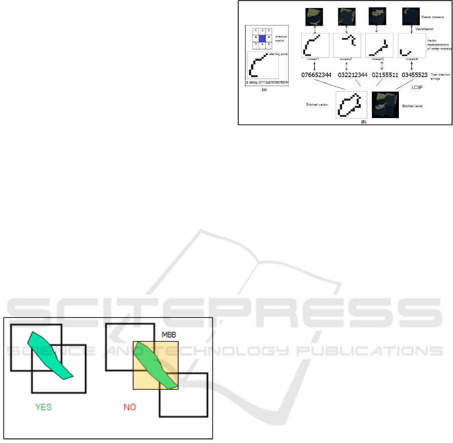
The first approach is based on point pattern
matching/point set registration technique. The
second approach is similar to the solution of the
longest common sub-sequence problem (LCSP).
After having done with stitching and extraction,
objects are obtained in the standard vector models
such as points, lines, line-strings and polygons with
their real coordinate values. In GIS standards are
defined by OGC. By this way, extracted objects can
be stored and serviced by spatial databases such as
PostgreSQL’s PostGIS and Oracle-Spatial. Figure 1
illustrates the overview of proposed framework.
Detailed information about each step will be given
following subsections.
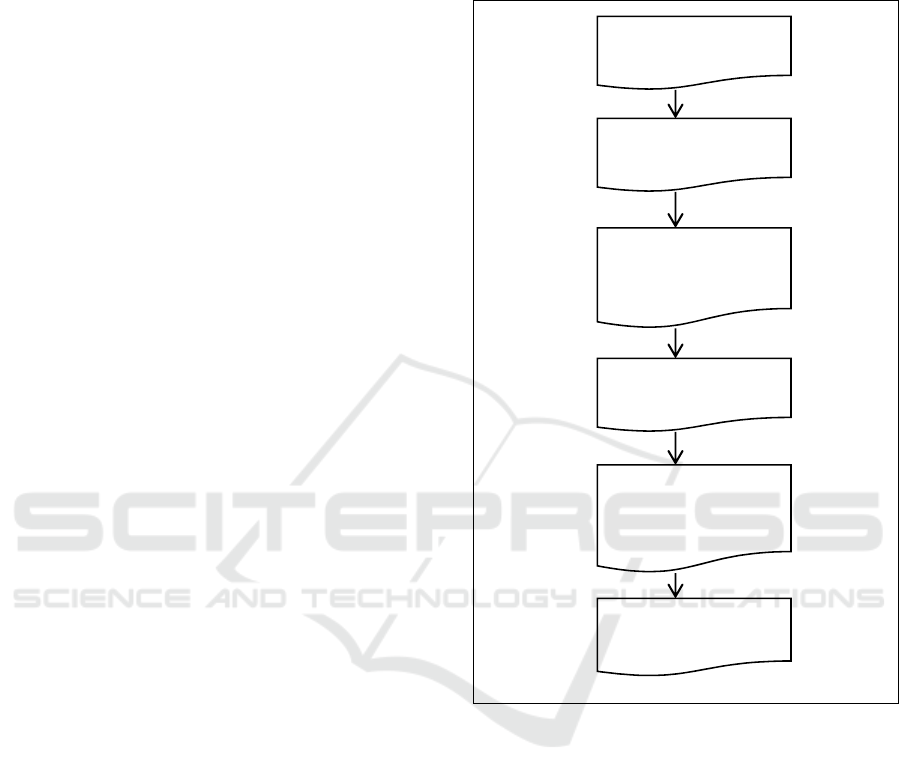
Figure 1: Steps of scalable big data framework.
4.1.1 Pre-processing of Mosaic Images
In the first step, high-resolution images to be
registered and their metadata such as geographic
corner coordinates as NW, NE, SW and SE are
obtained from LANDSAT-8 satellite launched by
NASA more recently. These mosaic images contain
two textures as “USGS” and “NASA”. To improve
result of the stitching process, these textures are
removed from mosaics as pre-processing step.
4.1.2 Identifying Mosaics to be Inputted for
Stitching Process
It is critical problem that which mosaics will be
selected for image stitching among big mosaic
dataset. In an earlier work, we propose two
Input data: large scale
satellite mosaic ima
g
es
Pre-processing of mosaic
ima
g
es
Polygon coverage
p
roble
m
Identifying mosaics to be
inputted for stitching
p
rocess
Stitching vectorised
images by two
alternative approaches
Object extraction and
spatial analysis
DCIT 2016 - Doctoral Consortium on Internet of Things
16
approaches to overcome mosaic selection problem
by means of finding rectangular sub regions
intersecting with range query. Former one is based
on hybrid of Apache Hadoop and HBase and latter
one is based on Apache Lucene. Their effectiveness
has been compared in terms of response time under
varying number of mosaics. In both approaches, we
focused on vertical scalability (different data sizes)
instead of horizontal scalability (Eken and Sayar,
2015b).
4.1.3 Polygon Coverage Problem
After identifying mosaics to be inputted for
stitching, we must test whether there is enough
mosaic images for interested objects or not. It is the
process of finding an answer to question of whether
a polygon (or spatial query window) is covered fully
by given other polygons or not (see Figure 2).
Covering problems arise in applications such as
telecommunications, spatial query optimization,
publish/subscribe middleware, and military sensor
coverage and targeting (Daniels and Inkulu, 2001;
Giachetta, 2014). For solving polygon coverage
problem, we are describing architecture to execute
distributed polygon covering algorithm on a Linux
cluster using Hadoop MapReduce.
Figure 2: Polygon coverage problem.
4.1.4 Vectorial based Stitching
In this stage, we suppose that we have all mosaics to
obtain object specified by user interactions with
reference maps. Vector representations of detected
raster mosaic images can be now stitched in
distributed computing model.
We propose two alternative approaches to stitch
large scale satellite mosaic images: (i) point pattern
matching/point set registration based and (ii) the
second approach is similar to the solution of the
longest common sub-sequence problem (LCSP).
The second approach is illustrated in Figure 3.
Figure 3: LCSP quasi vectorial based stitching.
Apache Hadoop is placed at the core of the
framework. To realize such a system, we first need
to define mapper and reducer functions, and then
their input and output formats. Moreover, in case of
having multiple levels of mapper and reducer
functions, high level process and data flow needs to
be defined. The first level mappers convert raster
mosaics into vector counterparts and the following
mappers and reducers are performed on the vector
mosaics. In near future, we will be sharing
information about two approaches in detail.
4.1.5 Object Extraction and Spatial Analysis
Spatial databases store and query data for spatial
objects in accordance with object relational database
model. While typical databases can only store and
manipulate various numeric and character types of
data, spatial databases can analyse spatial data types
such as point, line, and polygon. For the proof of
correctness and analysis of the proposed technique,
PostgreSQL and its PostGIS extension will be used.
5 EXPECTED OUTCOME
The outcomes of this study present valuable
knowledge about image processing with distributed
scalable big data frameworks. The product obtained
by this study can be used in applications requiring
spatial and temporal analysis on big satellite map
images. This study also shows that big data
frameworks are not only used in applications of text-
based data mining and machine learning algorithms,
but also used in applications of algorithms in image
processing. The effectiveness of the product realized
with this project is also going to be proven by
scalability and performance tests performed on real
world LandSat-8 satellite images.
A MapReduce based Big-data Framework for Object Extraction from Mosaic Satellite Images
17

6 STAGE OF THE RESEARCH
This paper provides with the background of the
research that will investigate into distributed and
scalable big data framework for stitching of mosaic
satellite images and object extraction. It has
explained the motivation of the research and the
methodologies and plan of work to be undertaken.
The current stage of the research is focusing initially
on the first three stages.
The next stage of this research will focus on
stitching vectorised mosaic images. Ultimately, as
mentioned above, the goal of this stage of the work
is to develop a solution to stitching problem. In this
way, output of our proposed framework can be used
by third parties (other researchers) for spatial and
topologic queries.
ACKNOWLEDGMENTS
This work has been supported by the TUBITAK
under grant 215E189.
REFERENCES
Ablimit A., Fusheng W., Hoang V., Rubao L., Qiaoling
L., Xiaodong Z., Joel S., 2013. Hadoop-GIS: A High
Performance Spatial Data Warehousing System over
MapReduce. Proceedings VLDB Endowment, 6(11):
1-33, 2013.
Ahmed E., Mohamed F. M., 2014. The Era of Big Spatial
Data. In Proceedings of the International Workshop of
Cloud Data Management.
Ahmed E., Mohamed F. M., 2013. A Demonstration of
SpatialHadoop: An Efficient MapReduce Framework
for Spatial Data. In VLDB.
Ahmed E., Mohamed F. M., Alharthi S., Alzaidy A.,
Tarek K., Ghani S., 2015. SHAHED: A MapReduce-
based System for Querying and Visualizing Spatio-
temporal Satellite Data. In ICDE.
Alarabi L., Ahmed E., Alghamdi R., Mohamed F. M.,
2014. TAREEG: A MapReduce-Based System for
Extracting Spatial Data from Open-StreetMap. In
SIGSPATIAL.
Daniels K., and Inkulu, R., 2001. Translational polygon
covering using intersection graphs. In Proceedings of
the 13th Canadian Conference on Computational
Geometry (CCCG'01), 61–64.
Dawn, S., Saxena, V., Sharma B., 2010. Remote sensing
image registration techniques: a survey. Image and
Signal Processing, Springer, 103–112.
Dean, J., Ghemawat, S., 2010. MapReduce: A Flexible
Data Processing Tool. Communications of ACM,
53(1), 72–77.
Eken, S. and Sayar A., 2015a. An Automated Technique
to Determine Spatiotemporal Changes in Satellite
Island Images with Vectorization and Spatial Queries.
Sadhana - Academy Proceedings in Engineering
Science, 40(1), 121–137.
Eken, S. and Sayar, A., 2015b. Big data frameworks for
efficient range queries to extract interested rectangular
sub regions. International Journal of Computer
Applications, 119(22), 36–39.
Ermias, B.T., 2011. Distributed Processing Of Large
Remote Sensing Images Using MapReduce: A case of
Edge Detection. Master Thesis, Münster, North-Rhine
Westphalia, Germany.
Giachetta, R., 2014. AEGIS - A state-of-the-art spatio-
temporal framework for education and research.
OSGeo Journal, 13, 68–77.
Golpayegani, N., Halem, M., 2009. Cloud Computing for
Satellite Data Processing on High End Compute
Clusters. IEEE International Conference on Cloud
Computing.
Lajiao C., Yan M., Peng L., Jingbo W., Wei J., Jijun H.,
2015. A review of parallel computing for large-scale
remote sensing image mosaicking. Cluster Computing,
18(2), 517–529.
Lv, Z., Hu, Y., Zhong, H., Wu, J., Li, B., Zhao, H., 2010.
Parallel K-Means Clustering of Remote Sensing
Images Based on MapReduce. Springer-Verlag Berlin
Heidelberg, 162–170.
Mamta B., Abhishek C.,Anshu P., Sivakumar V., 2013.
High Performance Computing for Satellite Image
Processing and Analyzing – A Review. International
Journal of Computer Applications Technology and
Research, 2(4): 424–430.
Royce, W., 1970. Managing the Development of Large
Software Systems. Proceedings of IEEE WESCON, 1–
9.
Sayar A., Eken, S., Mert, U., 2013. Registering LandSat-8
Mosaic Images: A Case Study on the Marmara Sea. In
IEEE 10th International Conference on Electronics
Computer and Computation, 375-377.
Sayar, A., Eken, S., Mert, Ü., 2014. Tiling of Satellite
Images to Capture an Island Object. Communications
in Computer and Information Science, Springer, 459,
195–204.
Smith, J., 1998. The book, The publishing company.
London, 2
nd
edition.
Winslett, M., Cary, A., Sun, Z., Hristidis, V., Rishe, N.,
2009. Experiences on Processing Spatial Data with
MapReduce. Scientific and Statistical Database
Management, Springer, 302–319.
Zitova, B., Flusser, J., 2003. Image registration methods: a
survey, Image and vision computing, 21, 977–1000.
DCIT 2016 - Doctoral Consortium on Internet of Things
18
