Especifying the Enterprise and Information Viewpoints for a
Corporate Spatial Data Infrastructure using ICA’s Formal Model
Italo L. Oliveira
1
, Jugurta Lisboa-Filho
1
, Carlos A. Moura
2
and Alexander G. Silva
2
1
Department of Informatics, Federal University of Viçosa, Viçosa, Minas Gerais, Brazil
2
Companhia Energética de Minas Gerais (CEMIG), Belo Horizonte, MG, Brazil
Keywords: Spatial Data Infrastructure, RM-ODP, Enterprise Viewpoint, Information Viewpoint.
Abstract: The International Cartographic Association (ICA) has proposed a formal model to describe Spatial Data
Infrastructure (SDI) using three of the five viewpoints of the RM-ODP (Reference Model for Open
Distributed Processing) framework, which was later adapted by other researchers. However, the adapted
ICA model has not been validated for corporate-level SDI. The Companhia Energética de Minas Gerais
(Minas Gerais Power Company - Cemig) seeks to develop an SDI to aid in discovering and reutilizing
spatial data within and outside the corporation. The present study aimed to assess the use of the model
proposed by the ICA to specify corporate-level SDI using SDI-Cemig as a case study by describing the
viewpoints Enterprise and Information. These viewpoints from the adapted ICA model have proved
appropriate to describe SDI-Cemig, whose differences are due to the SDI’s peculiarities. Although a single
study cannot validate the ICA model for a whole SDI level, this research shows that the adapted ICA model
can be used to describe the viewpoints Enterprise and Information in corporate SDI.
1 INTRODUCTION
Geospatial data are those referenced in relation to
the ground surface and are essential to aid in an
organization’s decision-making and planning.
However, according to Nebert (2004) and Rajabifard
and Williamson (2001), geospatial data are a costly
resource both in time and money involved in
surveying them. In order to cut down the costs
associated with using and obtaining geospatial data,
the Spatial Data Infrastructure (SDI) concept was
created.
There are several definitions for SDI. Rajabifard
and Williamson (2001) define SDI as an
environment in which the users reach their goals by
using technologies and collaboration. Harvey et al.
(2012) consider the SDI a concept that aids in
sharing data and geospatial services among different
users of a given community.
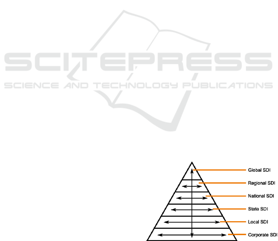
In order to help share and discover geospatial
data and services, the SDIs are organized
hierarchically. Figure 1 presents the SDI hierarchy
and the nomenclatures used in the present study.
According to Hjelmager et al. (2008), the SDI
concept is very broad and leads to different forms of
development both at the organizational and technical
level, as pointed out by Cooper et al. (2013). Thus,
the International Cartographic Association (ICA) has
developed a model to describe SDI regardless of the
technologies or implementations (Hjelmager et al.,
2008), a concept that was later extended by Cooper
et al. (2011); Béjar et al. (2012); Cooper et al.
(2013); and Oliveira and Lisboa-Filho (2015).
However, the use of ICA’s formal model for SDI
has not been evaluated to develop corporate-level
SDI yet. The Companhia Energética de Minas
Gerais (Cemig) is a mixed-economy company
acting in the electricity sector composed of over 200
partners and controlled by the government of the
Figure 1: SDI hierarchy – Adapted from Rajabifard and
Williamson (2001) and Crompvoet (2001).
Oliveira, I., Lisboa-Filho, J., Moura, C. and Silva, A.
Especifying the Enterprise and Information Viewpoints for a Corporate Spatial Data Infrastructure using ICA’s Formal Model.
In Proceedings of the 18th International Conference on Enterprise Information Systems (ICEIS 2016) - Volume 1, pages 271-282
ISBN: 978-989-758-187-8
Copyright
c
2016 by SCITEPRESS – Science and Technology Publications, Lda. All rights reserved
271
state of Minas Gerais (Brazil). Cemig seeks to
develop an SDI, named SDI-Cemig, to standardize
the processes that use the company’s geospatial data,
thus helping such data be shared and surveyed.
The present study presents the use of ICA’s
formal SDI model under SDI-Cemig’s specification
while detailing the viewpoints Enterprise and
Information and verifying whether this model allows
a corporate SDI to be appropriately described.
The remaining of the paper is structured as
follows. Section 2 describes ICA’s formal SDI
model, detailing the viewpoints Enterprise and
Information of an SDI. Section 3 presents the
specification of the viewpoints Enterprise and
Information for SDI-Cemig. Section 4 discusses the
results found in the present research, while Section 5
presents some final considerations of the study.
2 ICA’S FORMAL MODEL
According to Hjelmager et al. (2008), ICA’s formal
SDI model (henceforth called only formal model) is
a model that describes SDI regardless of
technologies, policies, or implementations. In order
to describe SDI, the ICA chose to use the RM-ODP
(Reference Model for Open Distributed Processing)
framework.
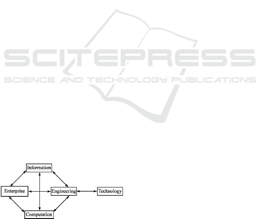
RM-ODP is an architectural framework
standardized by the International Organization for
Standardization/International Electrotechnical Co-
mmission (ISO/IEC) that is able to describe
heterogeneous distributed processing systems by
using viewpoints (Farooqui et al., 1995).
According to Raymond (1995), the use of the
viewpoint concept allows describing complex
distributed systems as smaller models, each of which
describes different relevant issues to different users
of the system. RM-ODP uses the following
viewpoints: Enterprise, Information, Computation,
Engineering, and Technology. Figure 2 presents the
five viewpoints and the relationship among them.
Figure 2: RM-ODP framework viewpoints – Adapted
from Hjelmager et al. (2008).
The viewpoint Enterprise describes the system’s
policies, scope, goal, and requirements for the
organization. The viewpoint Information details the
data semantics and the behavior in the system,
whose behavior will be restricted/determined by the
policies defined in the viewpoint Enterprise
(Farooqui, Logrippo and de Meer, 1995) (Hjelmager
et al., 2008). According to Cooper et al. (2013), the
viewpoint Computation describes the components
that make up the system and their interactions
through the interface with no concern about the
components’ physical distribution. The viewpoint
Engineering, according to Farooqui, Logrippo and
de Meer (1995), “identifies the requirements and
features needed for the system to support the model
described in the viewpoint Computation.” Finally,
the viewpoint Technology details the technological
devices used by the system.
ICA’s formal model describes only the
viewpoints Enterprise, Information, and
Computation. According to Hjelmager et al. (2008),
the viewpoints Engineering and Technology heavily
depend on the implementation and are not
considered in ICA’s model. The viewpoints
Enterprise and Information will be described in the
sub-sections below. The viewpoint Computation will
not be described since it is not relevant for this
study.
2.1 Enterprise Viewpoint
The viewpoint Enterprise, according to Hjelmager et
al. (2008), describes the actors and the relation
among the different parts of the system.
Figure 3 shows the relationship among the
different compounds that make up the SDI through a
diagram of UML classes. In the diagram, the SDI is
the central compound and its attributes are the scope
and a plan for its implementation. An SDI is formed
by products, which are in turn formed by geospatial
data and services from the SDI. The acquisition and
use of these products is the reason why a user will
use the SDI. Hence, the Product can be considered
the core part of the SDI (Hjelmager et al., 2008).
The Metadata will describe and be used by the
Product, and will be managed by the Processing
Tools to aid in the discovery and use of geospatial
data and services. The component Processing Tools
represents the systems that carry out some sort of
geospatial data processing and will connect to the
SDI through the component Connectivity, which will
use a certain Technology to perform its role.
According to Hjelmager et al. (2008), the
component Policies is responsible for defining the
ICEIS 2016 - 18th International Conference on Enterprise Information Systems
272
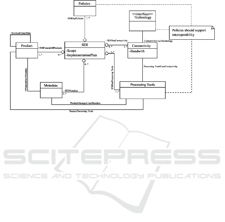
Figure 3: Components that make up an SDI – Hjelmager et al. (2008).
policies that will restrict and determine the SDI’s
functioning and evolution. Although this component
is represented by a single class, the component
Policies may be specialized into several other
classes, which will be shown ahead.
The actors are individuals with a stake on the
SDI’s success and may use it or contribute to it.
Hjelmager et al. (2008) defined five main actors for
the SDI, which were expanded by Cooper et al.
(2011) and Béjar et al. (2012). However, there are
differences in semantics and terminology between
the actors by Hjelmager et al. (2008) and Cooper et
al. (2001) and those proposed by Béjar et al. (2012).
This same characteristic holds true regarding the
SDI’s policies.
Oliveira and Lisboa-Filho (2015) unified the
actors and policies proposed by the ICA with those
proposed by Béjar et al. (2012). This way, the
designers that may use ICA’s model will have a
single set of possible actors and policies, which
facilitates communication and knowledge exchange
among designers.
Figure 4 presents the six main actors an SDI may
have: User; Producer; Operational Body; Governing
Body; Broker; Value-Added Reseller; and Provider.
According to Oliveira and Lisboa-Filho (2015),
the User is the actor that will use the resources
offered by the SDI to reach his or her goals. The
Producer is responsible for producing the SDI’s data
and services while the Provider makes these data
and services available. The Governing Body is
responsible for the SDI’s administration and its
attributions include creating, changing, and
removing policies. The Broker’s role is to aid in the
negotiations between providers and users. The
Value-Added Reseller (VAR) modifies an existing
product and makes it available in the SDI as a new
product. Finally, the Operational Body is
responsible for all the technical side of the SDI’s
functioning. All actors are specialized to describe
their attributions in more details. The specializations
can be found in Oliveira and Lisboa-Filho (2015).
Table 1 presents the policies unified by Oliveira
and Lisboa-Filho (2015). The policies were
specialized into: Business Model, Promotion,
Standards, Education, and Constraints. The
descriptions and specializations of each type are
shown in Table 1.
2.2 Viewpoint Information
According to Hjelmager et al. (2008), the viewpoint
Information in the RM-ODP framework describes
the system data, from their semantics to their
behavior, which are regulated by the policies defined
in the viewpoint Enterprise. In the case of an SDI,
Hjelmager et al. (2008) consider as data the products
offered by the SDI, i.e., the geospatial data and
services.
Figure 5 describes the relationship of the
products with the other SDI components using the
UML class diagram. The class Product, for being
the most relevant object in the viewpoint
Information, is the center of the diagram. The class
Especifying the Enterprise and Information Viewpoints for a Corporate Spatial Data Infrastructure using ICA’s Formal Model
273
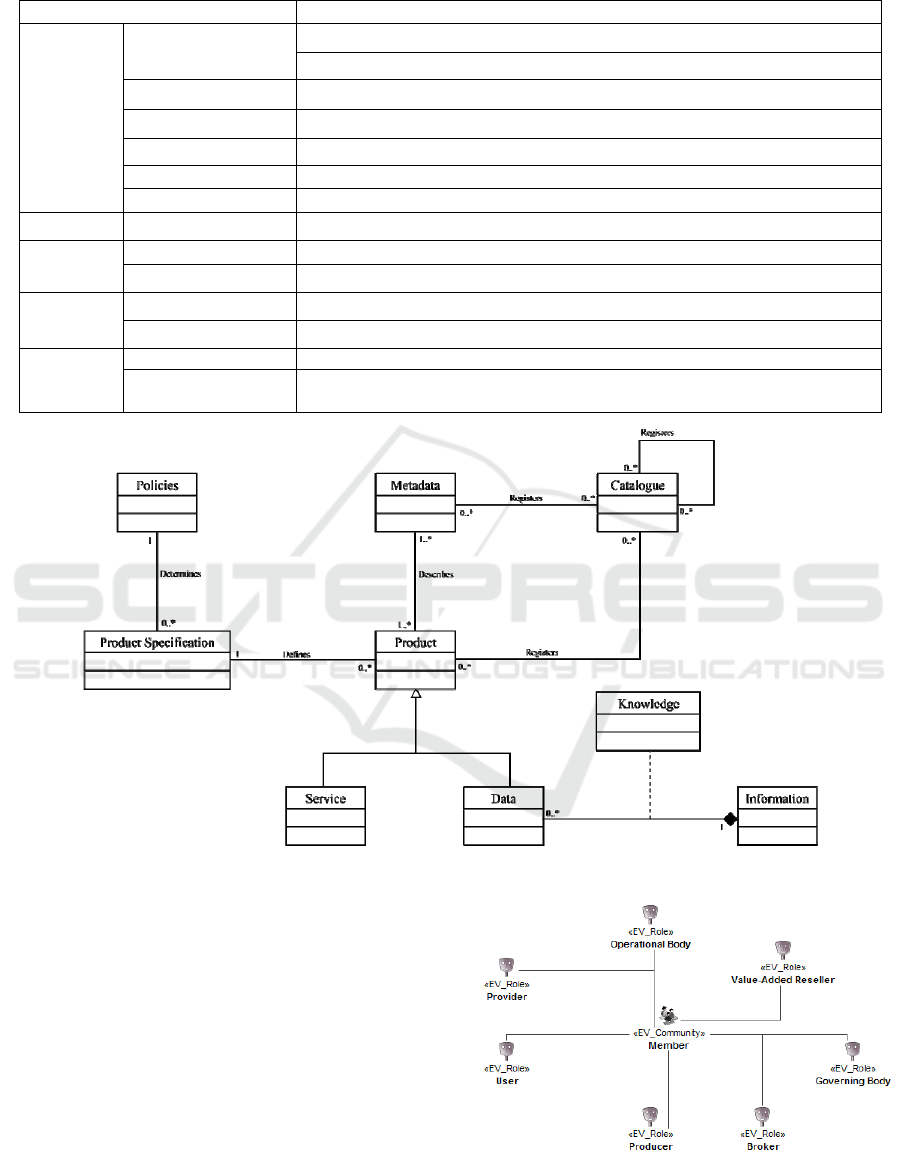
Table 1: SDI policies after the unification – Oliveira and Lisboa-Filho (2015).
Policies
Description
Business
Model
Governance
Determines the decision-making process
Regulates the policy-creation process
Membership Determines the relationships among the SDI members
Quality Defines the quality levels established in the SDI
Access Determines how the SDI products can be accessed and who can do it
Role Assignment Defines the responsibilities (actor roles) of the SDI users
Funding Defines how the resources will be forwarded to develop and maintain the SDI
Promotion - How the SDI will be advertised
Standards
- Defines the standards adopted by the SDI
Foundation Defines the main SDI products
Education
- Determines the trainings the SDI users may take part in
Best Practices Practices that must be adopted by the users member of the SDI
Constraints
Legal Constraints Restrictions imposed by local laws of where the SDI is located
Business
Agreements
Restrictions existing due to contract between companies
Figure 5: Class diagram for the viewpoint information – Hjelmager et al. (2008).
Policies represents the policies defined in the
viewpoint Enterprise, which will restrict and target
the product specifications, which are represented by
the class Product Specification (Hjelmager et al.,
2008).
The Products are described by the metadata
(class Metadata) and both are recorded in catalogs
(class Catalog), which may contain other catalogs to
allow for a hierarchy to be created. The products can
be classified into ervices and data (either geospatial
or not). The data are used, aided by previous
knowledge, as a source of information, which may
generate new knowledge (Hjelmager et al., 2008).
Figure 4: Main actors of an SDI after the unification –
Oliveira and Lisboa-Filho (2015).
ICEIS 2016 - 18th International Conference on Enterprise Information Systems
274

3 SDI-CEMIG
As specified in Section 1, Cemig seeks to develop an
SDI to help share and use geospatial data in the
companies that make up the conglomerate. The
model adapted from the ICA was used to specify the
SDI-Cemig so as to guarantee that the basic SDI
concepts in the literature would be contemplated
during the specification phase. The sub-sections
below describe the viewpoints Enterprise and
Information of SDI-Cemig.
3.1 Viewpoint Enterprise
As described in sub-section 2.1, the ICA has
described the parts that make up the SDI and the
possible actors that may interact with it. The
components and actors were identified in SDI-
Cemig to check whether they properly describe
corporate SDI.
3.1.1 Components of SDI-Cemig
The SDI is considered the central element in Figure
3 and has a scope and implementation plan
(Hjelmager et al., 2008). The scope of SDI-Cemig is
to make available online a set of geospatial layers
considered essential to the companies in the electric
sector and that may be used by Cemig’s employees
and clients, besides offering services to visualize and
discover geospatial data. The implementation plan of
SDI-Cemig will be publicized by the end of the
SDI’s development.
The component Product is made up of the SDI’s
geospatial data and services. SDI-Cemig has the data
of the geospatial layers considered basic for Cemig,
i.e., they are essential layers to the working of the
processes that involve geospatial data and are
described by the Foundation policies and detailed in
the conceptual model in sub-section 3.2.1.
SDI-Cemig must provide services for the
discovery, visualization, and recovery of geospatial
data, which must be compatible with the OGC
standards. The use of services based on the OGC
standards allows SDI-Cemig to interact with other
SDIs at different levels, such as the INDE
(Infraestrutura Nacional de Dados Espaciais –
National Spatial Data Infrastructure), the INSPIRE
(Infrastructure for Spatial Information in the
European Community), and the CGDI (Canadian
Geospatial Data Infrastructure). For a new service to
be considered compatible with the OGC standard, its
operations must follow the specifications proposed
in the documents provided by the OGC.
Although Figure 3 shows that the component
Product is self-related, since a service may generate
new data, SDI-Cemig has no processing service able
to produce new geospatial data at first.
The SDI products will be described by Metadata,
which are specified according to the Metadata
Geospatial do Brasil (Geospatial Metadata of Brazil
- MGB) profile (CONCAR, 2009). The MGB profile
defines the elements existing in the metadata that
describe the geospatial data to be introduced into the
INDE.
The metadata may be used by the Processing
Tools to help discover new geospatial data and
services and to obtain relevant information on them,
e.g., which features are offered by the services and
in which format the geospatial data is being made
available. In SDI-Cemig, the Processing Tools are
the legacy systems and desktop applications that use
the SDI’s geospatial data and services. Cemig has
several applications and legacy systems to process
geospatial data that are very important in the
company’s processes.
The component Connectivity specifies how the
Processing Tools interact with the SDI, which is
possible by using a Technology. Cemig’s legacy
systems and desktop applications interact with SDI-
Cemig by exchanging files in the XML format using
the GML standard as schema. Besides using files, the
desktop applications can interact with SDI-Cemig
through web services in case they are supported.
SDI-Cemig specifies at least one policy for each
type present in Table 1, except for Governance and
Business Agreements, which have no policy defined
yet. The policies will not be presented due to space
constraints. However, some policies will be pointed
out along the text.
3.1.2 Communities and Roles in SDI-Cemig
Besides the components in SDI-Cemig, the
viewpoint Enterprise specifies the communities that
make up the SDI and the possible roles they may
play to reach their goals.
A community is a concept of RM-ODP and is a
set of one or more entities that have similar behavior
and seek to reach a given common goal (Linington
et al., 2011). The behavior the communities may
take on are described through roles to facilitate them
being reused. In the case of SDI-Cemig, the possible
roles the communities may take on were described
by Hjelmager et al. (2008), Cooper et al. (2011), and
Béjar et al. (2012), were adapted and unified by
Oliveira and Lisboa-Filho (2015), and are used to
specify the communities.
Especifying the Enterprise and Information Viewpoints for a Corporate Spatial Data Infrastructure using ICA’s Formal Model
275
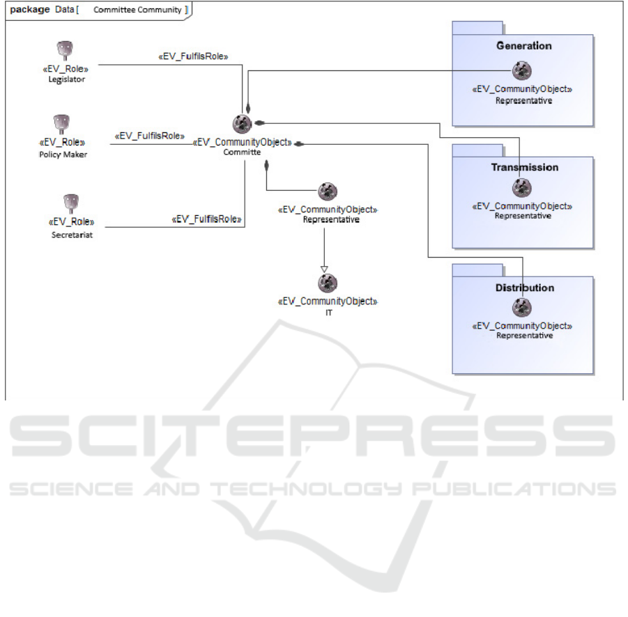
Figure 6: Community Committee and its respective roles.
According to Linington et al. (2011), a
community is specified by the roles it can take on,
its possible behaviors, the enterprise objects it uses,
and the goal it must reach. This sub-section,
however, details only the roles they may take on and
whether these roles match the roles unified by
Oliveira and Lisboa-Filho (2015).
Figures 6, 7, 8, and 9 present the communities
identified in Cemig’s environment and the roles they
may take on when interacting with SDI-Cemig. In
Figure 6, the community Committee is formed by
members of different sectors at Cemig, represented
by the communities Representative, such as
Information Technology (IT) and the sectors
Generation, Transmission, and Distribution, and its
attribution is to define the working of certain
processes carried out by these sectors. Hence, the
Committee takes on the roles of Legislator,
Secretariat, and Policy Maker and is responsible for
all of SDI-Cemig’s administrative area.
The community GIS Analyst (Figure 7)
represents the IT individuals with positions
homonymous to the community, who are responsible
for carrying out and analyzing the procedures
performed in a Geographic Information System
(GIS) to manipulate geospatial data.
As shown in Figure 7, the Geoprocessing Analyst
may take on the roles of Data/Service Distributor,
Data and Metadata Aggregator/Integrator, and
Négociant. The community is responsible for
providing the geospatial data and services produced
by the Producers in SDI-Cemig.
The community is also responsible for
purchasing the geospatial data the users require, then
acting as a Négociant. Finally, the Geoprocessing
Analyst, when carrying out procedures on the
geospatial data in a GIS, is able to generate new
geospatial data or to expand existing data, thus
taking on the role of Data and Metadata
Aggregator/Integrator. Moreover, the IT will be in
charge of creating and maintaining the catalogs of
data and services made available by SDI-Cemig by
using user-produced metadata.
Cemig has several sectors that act in the processes
of electric energy generation, transmission, and
distribution. The generation process consists in the
generation of electricity through power plants and
Cemig has hydroelectric, thermal, wind, and solar
plants. Transmission consists in a network that carries
the energy produced by the power plants to the large
consuming centers. Finally, distribution is the
network that serves energy to small- and medium-
sized companies and to residential consumers (Leão,
2009).
ICEIS 2016 - 18th International Conference on Enterprise Information Systems
276

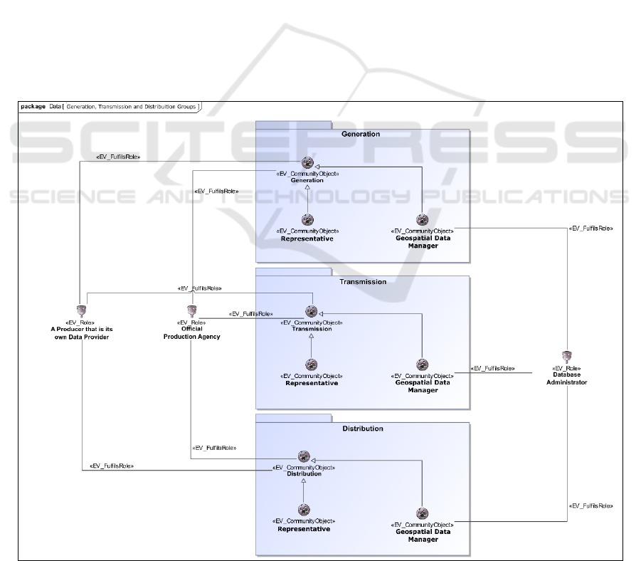
The generation, transmission, and distribution
groups are represented in Figure 8 by packages
comprising all the sectors related to each group.
Since there is a large number of sectors related to
each group, they are represented by the communities
Generation, Transmission, and Distribution. Besides
these communities, each group has a Geospatial
Data Manager and a Representative.
Each group has its Spatial Data Manager
community, which is responsible for guaranteeing
data consistency for each group, hence it takes on
the role of Database Administrator. However, it
must be pointed out that Cemig has a position called
Database Administrator, although its role is different
from the one defined by Cooper et al. (2011). At
Cemig, the position Database Administrator is in
charge of guaranteeing that the database and the
hardware supporting it are in order.
The community Representative is a generic
community used to illustrate the individuals that
represent the interests of each group in the community
Committee. Finally, each group has a homonymous
community (Generation, Transmission, and
Distribution) that represents the different sectors at
Cemig that work directly or indirectly with the data of
that group. The communities Generation,
Transmission, and Distribution are considered
Official Production Agencies since they are the main
data producers in SDI-Cemig and since their sectors
belong to Cemig. These communities are also
responsible for publicizing the data they produce in
the SDI, thus taking on the role of A Producer that is
its own Data/Service Provider.
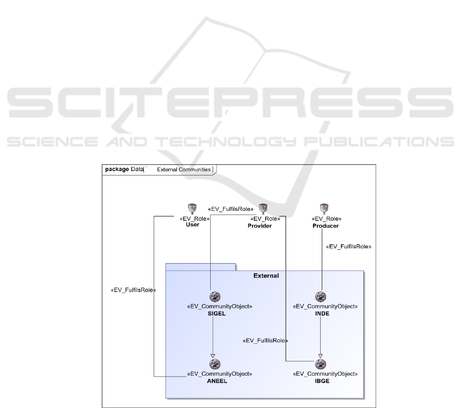
SDI-Cemig interacts with other communities
besides those within Cemig itself by interacting with
other SDIs and organizations, as shown in Figure 9.
The community of the Instituto Brasileiro de
Geografia e Estatística (Brazilian Institute of
Geography and Statistics - IBGE) is the federal
public organ that produces nationwide geospatial
data, besides being responsible for defining the
standards to be used by the other geospatial-data-
producing organizations, thus taking on the role of
Producer. The data produced by the IBGE are
publicized through the INDE. SDI-Cemig interacts
with the INDE and recovers the data available
through web services, which makes the INDE a
Provider of SDI-Cemig.
Besides the INDE, SDI-Cemig will obtain and
publicize information to the Sistema de Informações
Geográficas do Setor Elétrico (Geographic
Information System of the Power Sector - SIGEL)
belonging to the Agência Nacional de Energia
Elétrica (National Electric Energy Agency -
ANEEL). ANEEL is responsible for regulating and
overseeing the Brazilian electric energy market to
guarantee that the companies working in the country
follow the regulations in effect. The SIGEL is a
system that allows the visualization and obtention of
some geospatial data made available by the utility
companies to ANEEL. Therefore, ANEEL takes on
the role of User in SDI-Cemig by recovering the
Figure 7: Geoprocesing Analyst Community and its respective roles.
Especifying the Enterprise and Information Viewpoints for a Corporate Spatial Data Infrastructure using ICA’s Formal Model
277
data through the GeoPortal or through web services,
while the SIGEL takes on the role of Data Provider
by making available to SDI-Cemig the data provided
to ANEEL by the other utility companies.
3.2 Viewpoint Information
As well as in the viewpoint Enterprise, the
components defined by Hjelmager et al. (2008) for
the viewpoint Information, shown in Figure 5 in sub-
section 2.2, are identified in SDI-Cemig.
According to Linington et al. (2011), the
viewpoint Information is responsible for “modeling
the shared information that is handled by the
system.” Therefore, the invariant scheme of the
geospatial database used in SDI-Cemig is modeled.
The dynamic and static schemes are not modeled
because SDI-Cemig, having only geospatial data,
contains little or no dynamically generated data due
to an action. When geospatial data are represented in
alphanumeric format, comparing them to the original
data to check whether the representation is
consistent becomes difficult.
According to Hjelmager et al. (2008), the model
presented in Figure 5 begins with the component
Policies, which defines the basic geospatial data
(layers) the SDI must have, besides allowing the link
with the viewpoint Enterprise. The basic data SDI-
Cemig has are described in the policies Foundation.
It must be pointed out that much of the data in SDI-
Cemig are related to the electricity generation,
transmission, and distribution.
The members of SDI-Cemig may request new
products (data and services) by opening a ticket with
Cemig’s helpdesk, being limited by the policies.
Such tickets are considered the products’
specifications (component Product Specification).
The Products are described by Metadata, which
allows the users to assess whether the product meets
their needs, besides facilitating searching for them.
According to the policy Legal Constraints “Adoção
do Decreto de Lei Nº 6.666 – Uso do perfil MGB
para a documentação de metadados geoespaciais
produzidos em território nacional,” the products in
SDI-Cemig will be described using metadata
documented following the specification of the MGB
profile (CONCAR, 2009).
Figure 8: Groups Generation, Transmission, and Distribution with their respective communities and roles.
ICEIS 2016 - 18th International Conference on Enterprise Information Systems
278
Both Metadata and Products will be recorded in
a Catalog to aid in their discovery. The catalogs will
be created according to the topics of the geospatial
data offered by SDI-Cemig such as hydrography,
generation, transmission, distribution, infrastructure,
etc. According to the model in Figure 5, the data
generate information based on pre-established
knowledge. In SDI-Cemig, the data are used to
generate information used by the different sectors at
Cemig through reports and maps. Such information
is generated based on the knowledge of employees
specialized in geoprocessing, usually Geoprocessing
Analysts.
3.2.1 Conceptual Database Modeling
According to Béjar et al. (2012), the policies of the
type Foundation define the basic data and services
the SDI must have. However, only the database
description is not able to show the relationship
among the data or how they will behave in the
system, which is one of the goals the viewpoint
Information aims to represent.
Figure 10 presents the conceptual scheme of the
database adopted by SDI-Cemig. Due to space
constraints, only the layers related to electricity
generation, transmission, and distribution will be
represented.
The UML class diagram extended with
geographical and topological builders of the OMT-G
(Borges, Davis Jr. and Laender, 2001) was used to
create the scheme.
The package Distribution Grid has layers related
to Cemig’s regional distribution grid and layers that
help manage this grid. The layer
Malha_Regional_Distribuicao represents the limit
of the distribution areas, which contain a
headquarters (Malha_Regional_Sede) inside them.
The business units (Unidades_Negocio) are areas
defined according to the type of business Cemig
intends to establish in a given region, which aids in
planning and in the decision-making process. As
well as the regional grid, the business units have a
headquarters (Unidades-Negocio_Sede).
The area where Cemig can work in the state of
Minas Gerais, negotiated with the state’s
government, is represented by the class
Areas_Concessao_Distribuicao, while the class
Local_Cemig_Concessao represents the area where
Cemig is currently working. To help in the decision-
making process, Cemig has divided the state of
Minas Gerais into several regions called
transmission regions (Regionais_Transmissao). As
well as the distribution grid, the transmission regions
are divided according to criteria that meet the
company’s business rules.
The packages Generation, Transmission, and
Distribution contain the classes that represent the
elements that make up the electric grid administered
by Cemig. Cemig’s electric grid nodes comprise
structures, namely Estruturas_LT for Generation,
Estrutura_LT_230-500 for Transmission, and
Estrutura_LT_34-161 for Distribution. The classes
Figure 9: External communities that interact with SDI-Cemig.
Especifying the Enterprise and Information Viewpoints for a Corporate Spatial Data Infrastructure using ICA’s Formal Model
279

Vao_LT, Vao_LT_230-500, and Vao_LT_34-161
represent, respectively, the arcs of Generation,
Transmission, and Distribution.
The structures that make up the Generation
nodes comprise power plants, which can be
hydroelectric, wind, or solar (Usinas_Hidreletricas,
Usinas_Eolicas, Usinas_Solares, respectively), and
by Centrais_Geradoras_Hidreletricas,
Subestacoes_Geracao, and
Pequenas_Centrais_Hidreletricas. Although it is
said in the subsection 3.1.2 that Cemig owns thermal
power plants, they are not considered, at the first
moment, in the conceptual model.
In Transmission, the only structures that make up
the network are the transmission sub-stations
(Subestacoes_Transmissao). In Distribution, the
structures comprise Postes (poles) and
Subestacoes_Distribuição. The poles may have a
transformer. Generation, Transmission, and
Distribution have, respectively, the classes
Linhas_Transmissao, Linhas_Transmissao_230-500,
and Linhas_Transmissao_34-161. These classes are
used to identify a portion of the network, which
must comprise at least an arc and its respectively
beginning and end nodes.
4 DISCUSSION OF RESULTS
The adapted ICA model proved appropriate to
describe the viewpoints Enterprise and Information
of SDI-Cemig. The differences found between the
model and the specification are due to the specific
characteristics of SDI-Cemig.
One such difference is that there are no
geoprocessing services. In the viewpoint Enterprise,
the lack of geoprocessing services impacts the
component Product, which cannot be self-related.
In addition, the existence of the component
Technology in ICA’s formal model contradicts the
goal of the viewpoint Enterprise in the RM-ODP
framework, which is to describe the system’s scope,
policies, and requirements. This contradiction can be
extended to the component Connectivity, however,
further studies are needed to state that.
Also regarding the viewpoint Enterprise, during
the specification of the actors in SDI-Cemig, the
concentration of positions in the IT community
becomes visible, which are responsible for providing
data to SDI-Cemig, performing maintenance in
smaller systems, negotiating new geospatial data,
and creating new policies. Many of these
responsibilities are beyond the scope IT should take
on in SDI-Cemig.
Regarding the policies, the ones related to the
type Governance have not been defined yet.
Moreover, other types of policies have a small
number of policies specified (usually a single policy
has been specified for each type).
The viewpoint Information of SDI-Cemig has all
the components specified by the adapted ICA model,
with no need to change their behavior or semantics.
Although the adapted ICA formal model
describes SDI at all levels and, thus, guarantees the
basic concepts in the literature are contemplated in
the specification phase, there is no description of
how the model should be used. For instance, how
many details are required to describe the
components of the viewpoint Enterprise, or what
could be considered a product specification?
5 FINAL CONSIDERATIONS
Using the adapted ICA formal model allows the key
components of an SDI to be contemplated in the
design phase, besides allowing a better
understanding of the basic concepts such as the SDI
structure, who the users will be and what roles they
will take on when using an SDI, how the policies
will impact the SDI development, etc.
The viewpoints Enterprise and Information in
ICA’s formal model properly describe these
viewpoints in SDI-Cemig and, although the
specification of a single corporate SDI does not
ensure the model will be applicable at any corporate
level, it does indicate the viewpoints Enterprise and
Information in ICA’s formal model can be applied to
other corporate SDIs. Moreover, the present study
may help other designers wanting to use ICA’s
model to specify new SDIs regardless of their level.
As future works, we intend to specify the
viewpoint Computation in SDI-Cemig to verify
whether it is in accordance with the viewpoint
Computation specified in the adapted ICA model.
ICEIS 2016 - 18th International Conference on Enterprise Information Systems
280
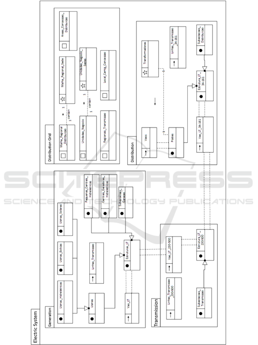
Figure 10: Layers related to the electric system and the distribution grid of the state of Minas Gerais from the conceptual
scheme of SDI-Cemig’s database.
Especifying the Enterprise and Information Viewpoints for a Corporate Spatial Data Infrastructure using ICA’s Formal Model
281

ACKNOWLEDGEMENTS
This project was partially funded by the Brazilian
research promotion agencies Fapemig and CAPES,
along with Cemig Enterprise.
REFERENCES
Béjar, R., Latre, M. Á., Nogueras-Isso, J., Muro-Medrano,
P., R., Zarazaga-Soria, F., J., 2012. An RM-ODP
Enterprise View for Spatial Data Infrastructure.
Computer Standards & Interfaces, v. 34, n. 2, p. 263-
272.
Borges, K. A. V., Davis Jr., C. A., Laender, A. H. F.,
2001. OMT-G: An Object-Oriented Data Model for
Geographic Applications. Geoinformatica, v. 5, n. 3, p.
221-260.
CONCAR – Comissão Nacional de Cartografia, 2009.
Perfil de Metadados Geoespaciais do Brasil (Perfil
MGB). Available at: http://www.concar.ibge.gov.br/
arquivo/perfil_mgb_final_v1_homologado.pdf.
Cooper, A. K., Moellering, H., Hjelmager, J., et al., 2013.
A Spatial Data Infrastructure Model from the
Computational Viewpoint. International Journal of
Geographical Information Science, v. 27, n. 6, p.
1133-1151.
Cooper, A. K., Rapant, P., Hjelmager, J., et al., 2011.
Extending the Formal Model of a Spatial Data
Infrastructure to Include Volunteered Geographical
Information. 25
th
Cartographic Conference (ICC).
Crompvoet, J., 2011. Spatial Data Infrastructure and
Public Sector. Available at: http://www.spatialist.be/
eng/act/pdf/20111107_sdi_intro.pdf.
Farooqui, K., Logrippo, L., De Meer, J., 1995. The ISO
Reference Model for Open Distributed Processing: and
introduction. Computer Networks and ISDN Systems,
v. 27, n. 8, p. 1215-1229.
Harvey, F., Iwaniak, A., Coetzee, S., Cooper, A., K., 2012.
SDI past, present and future: a review and status
assessment. Spatially Enabling Government, Industry
and Citizens.
Hjelmager, J., Moellering, H., Cooper, A. K., et al., 2008.
An Initial Formal model for Spatial Data
Infrastructure. International Journal of Geographic
Information Science, v. 22, n. 11-12, p. 1295-1309.
Leão, R., 2009. GTD – Geração, Transmissão e
Distribuição de Energia Elétrica. Universidade Federal
do Ceará, Centro de Tecnologia, Departamento de
Engenharia Elétrica. Available at:
http://www.clubedaeletronica.com.br/Eletricidade/PD
F/Livro%20GTD.pdf. (in Portuguese).
Linington, P. F., Milosevic, Z., Tanaka, A., Vallecilo, A.,
2011. Building Enterprise Systems with ODP: An
Introduction to Open Distributed Processing. CRC
Press.
Nebert, D., D., Techinical Working Group Chair GSDI,
2004. Developing Spatial Data Infrastructures: The
SDI Cookbook. V.2. GSDI – Global Spatial Data
Infrastructure. Available at: http://www.gsdi.org/
docs2004/Cookbook/cookbookV2.0.pdf.
Oliveira, I. L., Lisboa-Filho, J., 2015. A Spatial Data
Infrastructure Review – Sorting the Actors and
Policies from Enterprise Viewpoint. Proceedings of
the 17
th
International Conference on Enterprise
Information Systems, v. 17, p. 287-294.
Rajabifard, A., Williamson, I., P., 2001. Spatial Data
Infrastructures: concept, SDI hierarchy and future
directions. Proc. of GEOMATICS Conference, p. 10.
Raymond, K., 1995. Reference Model for Open
Distributed Processing (RM-ODP): Introduction. Open
Distributed Processing, p. 3-14.
ICEIS 2016 - 18th International Conference on Enterprise Information Systems
282
