
TECHNICAL VIABILITY STUDY FOR BEHAVIORAL
MONITORING OF WILDLIFE ANIMALS IN DOÑANA
An 802.15.4 Coverage Study in a Natural Park
M. Dominguez-Morales, A. Jimenez-Fernández, D. Cascado-Caballero,
A. Linares-Barranco, R. Paz, G. Jiménez-Moreno
Robotic and Technology of Computers Lab, University of Seville, ETSII Av. Reina Mercedes s/n, Seville, Spain
R. Soriguer
Biological Station of Doñana, CSIC, Av. Americo Vespucio. EDB-CNM, Seville, Spain
Keywords: Wireless sensor networks, WSN, XBee, ZigBee, 802.15.4, Motes, Wireless coverage, Wild animals,
Doñana.
Abstract: The study and monitoring of wildlife and in semi-freedom has always been a subject of great interest. In
recent years the technology allows to design low cost systems that facilitate these tasks: microcontrollers,
low-power wireless networks, sensors. GPS, satellite and VHF has been used for position tracking and
localization of wildlife. Our aim is to design a low-cost system for local monitoring of wildlife (collar or
harness) with local memory and remote access. It will use multiples sensors for behavioral and health
monitoring and fuse the processed information locally to reduce the stored data, but allowing to be
sporadically transmitted through wireless networks. This collar will be based on an embedded low-power
microcontroller with 802.15.4 transceiver and a set of sensors to provide data (activity and health) of the
animal under monitoring: accelerometers, compass, humidity, temperature, light, microphone, heart rhythm.
This collar is called mote in wireless sensors network (WSN) terminology. Only when one mote is closer to
an 802.15.4 mote and under request, the collar will dump the information to a host database server through
the 802.15.4 network. In this paper we present a viability study of the WSN for Doñana Natural Park for
different mote transmission powers, frequencies and distances for coverage. ZigBee and XBee mote has
been proven.
1 INTRODUCTION
The monitoring of animal life can be classified into
two groups: monitoring wildlife and livestock
operations monitoring extensive. During the second
half of the twentieth century basically three wildlife
tracking methods were used: Haller (2001),
Markham (2008), Findholt (1996) and Mech (2002)
by VHF tracking, by GPS and by Satellite. The
traditional VHF system collapse as soon as it started
using multiples collars because of the scarcity of
frequencies assigned, which began to codify the
signs that each collars forward to optimize
localization, as in Allen (2009) work. Satellite
localization mechanisms (Argos in particular) are so
expensive that only migratory animals were used in
the continent, as in Mech (2002) and Vodafone
references. Back in the nineties years, localization
mechanisms were implemented based on fixed
nodes covering a wide area by triangulation (without
using GPS) with a precision of 50 meters. This was
subsequently improved by GPS obtaining a higher
precision, see Rempel (1995). Some of the systems
referenced are the ZebraNet that apart of using GPS
to implement localization, it includes other sensors
to detect the monitored animal activity. However,
the main characteristics of our system is that it stores
the data collected locally and that these may be
transferred between different collars until they are
collected by the researcher.
The ZebraNet system, see Juang (2002),
describes mechanisms for data collection from
different sensors in order to process the information
off-line. This allows finding patterns in information
that can be associated to the various activities of
98
Dominguez-Morales M., Jimenez-Fernández A., Cascado-Caballero D., Linares-Barranco A., Paz R., Jiménez-Moreno G. and Soriguer R..
TECHNICAL VIABILITY STUDY FOR BEHAVIORAL MONITORING OF WILDLIFE ANIMALS IN DOÑANA - An 802.15.4 Coverage Study in a Natural
Park.
DOI: 10.5220/0003524300980101
In Proceedings of the International Conference on Data Communication Networking and Optical Communication System (DCNET-2011), pages 98-101
ISBN: 978-989-8425-69-0
Copyright
c
2011 SCITEPRESS (Science and Technology Publications, Lda.)

animal: eat, hunt, sleep,... The possibility that this
pattern recognition can be performed locally on each
collar on the animal is very attractive because it
reduces the transmission time and the information
post processing.
In this paper we present the results of a viability
study of applying WSN for these collars in the
Doñana Natural Park. The viability study is focused
on 802.15.4 networks with different power
transmissions and two different frequencies:
868MHz and 2.4GHz.
Next section presents a review of 802.15.4 WSN,
focusing on ZigBee and XBee standards. Section 3
presents the scenario for the viability study. Then in
section 4 we present some results and finally we
present the conclusions and future work in section 5.
2 WSN TECHNOLOGIES
802.15.4 (Zigbee Alliance web page:
http://www.zigbee.org) is the most representative
example of Wireless Sensor Networks (WSN). It is a
standard that covers several PHY layers and one
MAC layer, aiming to give low rate network service
to devices with low capacity batteries. Expected
battery operation time is 4 to 6 months for button
batteries. Data rates were defined to 250Kbps at
maximum, but lower data rates are possible by
choosing the appropriate PHY layer or changing the
MAC parameters. Communications security is
ensured by AES encryption and coexistence is
solved by channel selection and features such as
quality of service or noise carrier sensing help to
avoid busy channels. Location information is
possible through triangulation of RSSI (as
implemented in Chipcon CC2431 chips), as in
Merrett (2008). Network topologies allowed are
centralized (star topology with a network master) or
Ad-Hoc (peer to peer communications without
master). In star topology, beacon enabled
communications make possible to reserve
transmission slots, guaranteeing data rates and
making soft real time applications possible.
802.15.4 is the base of Zigbee that tries to give a
complete solution (with more layers and profiles) to
low-rate, low-power personal area networks. A
profile is a set of protocols and definitions (such as
type of messages, IDs, etc) that must be
implemented in case of adopting a specific profile in
order to achieve interoperability between devices.
One example of this is the recently approved Zigbee
Health Care Profile, which offers an open standard
for health monitoring and management devices,
offering a wide variety of health-care oriented
services and protocols.
3 TESTING SCENARIO
Doñana National Park, see Doñana (1994) reference,
in Andalusia occupies the right bank of the
Guadalquivir River at its estuary on the Atlantic
Ocean. It is notable for the great diversity of its
biotopes, especially lagoons, marshlands, fixed and
mobile dunes, scrub woodland and maquis. The
faunal inventory includes 8 species of fish, 10
amphibians, 19 reptile, 30 mammal and 360 bird. It
is one of the largest heronries in the Mediterranean
region and is the wintering site for more than 500K
water fowl each year. Doñana National Park has
been a testing ground for conservation in Spain and
has become very well known throughout Europe due
to the controversies faced there and the innovative
management approaches that have been taken. It is
the only protected area that is not only a National
Park but also a Ramsar site, a Biosphere Reserve as
well as a European Community Special Protection
Area. It is also known as the site which triggered the
foundation of WWF in 1961.
The Doñana Scientific Reserve (DBR) is made
up by two estates with a surface area of 10,000
hectares, included in the 50,000 hectares of Doñana
National Park.
This area includes 4 large ecosystems: beaches,
dunes, scrubland, and marshland. The fauna includes
41 species of ants, 7 of freshwater fish, 30 of estuary
fish, 11 of amphibians, 19 of reptiles and 20 of
mammals. DBR has an important infrastructure for
scientific research: accommodation rooms, field
laboratories, a fleet of 4 wheel-drive cars, horses,
boats; and personnel.
In april 2006, the Interministerial Commission of
Science and Technology (CICYT) part of the
Ministry of Education and Science approved the
recognition as Singular Scientific and Technological
Infrastructure (ICTS) to the Scientific Reserve of
Doñana. ICTS was created with two objectives: (a)
providing modern communications and scientific
equipments infrastructure to the Reserve in order to
allow the standardization and automation of
monitoring natural processes, and for developing
research activities that could not be possible without
the ICTS. And (b) providing access to these facilities
and welcoming to the scientific community to
develop research activities.
The ICTS is equipped with an extensive
audiovisual network for monitoring; a meteorology
TECHNICAL VIABILITY STUDY FOR BEHAVIORAL MONITORING OF WILDLIFE ANIMALS IN DOÑANA - An
802.15.4 Coverage Study in a Natural Park
99
and microclimatology monitoring network;
atmospheric measurements equipments; hydrology
and limnology; geomorphology; flora and vegetation
natural process monitoring; wildlife census; flow of
water and CO2; knowledge of the land on which sits
the vegetation; geolocalization through various
schemes like FindAve (GPRS and Wifi), RTLS over
Wifi, RFID, ultrasound or harmonic radar detectors.
Several 802.11 antennas warranty coverage for
wireless internet access inside the Reserve.
In order to study the viability of the
communications for wildlife monitoring, two
different 802.15.4 frequencies has been tested in this
work: 2.4GHz and 868MHz with different
transmission power and protocol standards: ZigBee
2.4GHz 10mW and XBee 868MHz 300mW
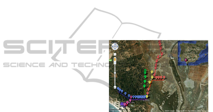
Four main zones of the Reserve were selected for
the study: Ojillo (blue route in figure 1): is a forest
zone, relatively plane; Santa Olalla (pink route in
figure 1): lagoon zone very close to dunes with low
density of vegetation; Humedales (red route in
figure 1): completely open zone, more than 15Km of
free obstacles floodplain, but completely dry area
during our study; and Dunas (purple route in figure
1): this area is close to the sea. There are dunes that
are shifting.
4 RESULTS
Figure 1 shows a google map of Doñana. The map
shows several routes for the coverage study.
Two coverage tests have been performed for
Texas ZigBee 2.4GHz and low power ZigBee
transceivers. First one was done in a relatively open
field (at Santa Olalla), and another on a tree zone
(Ojillo). The maximum coverage range measured
was around 250m and 60m respectively. This is due
not only to the power of transmission but also to the
absorption property of 2.4 GHz signals versus
868MHz signals. 2.4GHz signal is more absorbed by
vegetation than 868MHz.
868MHz XBee coverage study consisted in
testing the efficiency of the link between two XBee
transceivers at 868MHz and 300mW transmission
power. In the Palace of Doñana there is a 25 meters
high tower. In this tower we set up the base-station
for the measurements (bottom yellow point in figure
1). The base-station equipment was composed by
one XBee mote connected to a laptop through USB
and a software application written in C# is used in
order to manage information between motes. This
software application contains functions, procedures
and state machines to implement the communication
through XBee. Once the software application is
running, it sends a broadcast packet asking for mote
discovery, and then it keeps waiting for answers.
When at least one mote have been discovered, and
using a software timer, the first mote will
continuously be transmitting information using a
point to point link to the just discovered mote,
transmitting one packet per second. Furthermore, the
XBee transceiver is able to make remote AT
commands request, this feature is used by tower
mote for requesting information about the power of
last received radio packet for each timer overflow.
Power radio reception measurement is returned to
tower mote as a dB magnitude. Thank to the use of
application software, we can characterize the quality
and radio power of the transceiver links for the
Doñana Biological Reserve scenario.
Figure 1: Google map of Biological Reserve of Doñana.
Blue route from Palacio to Matalascañas route ended
around Ojillo. Pink route from Palacio to Dunes. Purple
route on Dunes. Green and red routes on Humedales.
The second mote consists on an XBee 868 MHz
transceiver at 300mW connected to a
microcontroller. The microcontroller is continuously
retransmitting the same incoming packet. Therefore,
the tower mote will receive the same transmitted
packet with information about the signal intensity in
dB thanks to the use of AT commands supported by
XBee transceiver. During the different tested routes
we have taken the GPS coordinates at each point of
each route of figure 1. At these points we have
measured the signal intensity in dB of the link on the
tower side for two different position of the mote (2m
high and 0.5m high). Figure 2 shows a graph per
each significant route. It can be seen that the signal
is quite good for really open fields (Humedales),
obtaining a coverage range of up to 13Km, while for
tree zones (Ojillo), the coverage rage decreases to
6Km and the signal intensity increases when
measurements are made in a dense tree zone. At
DCNET 2011 - International Conference on Data Communication Networking
100
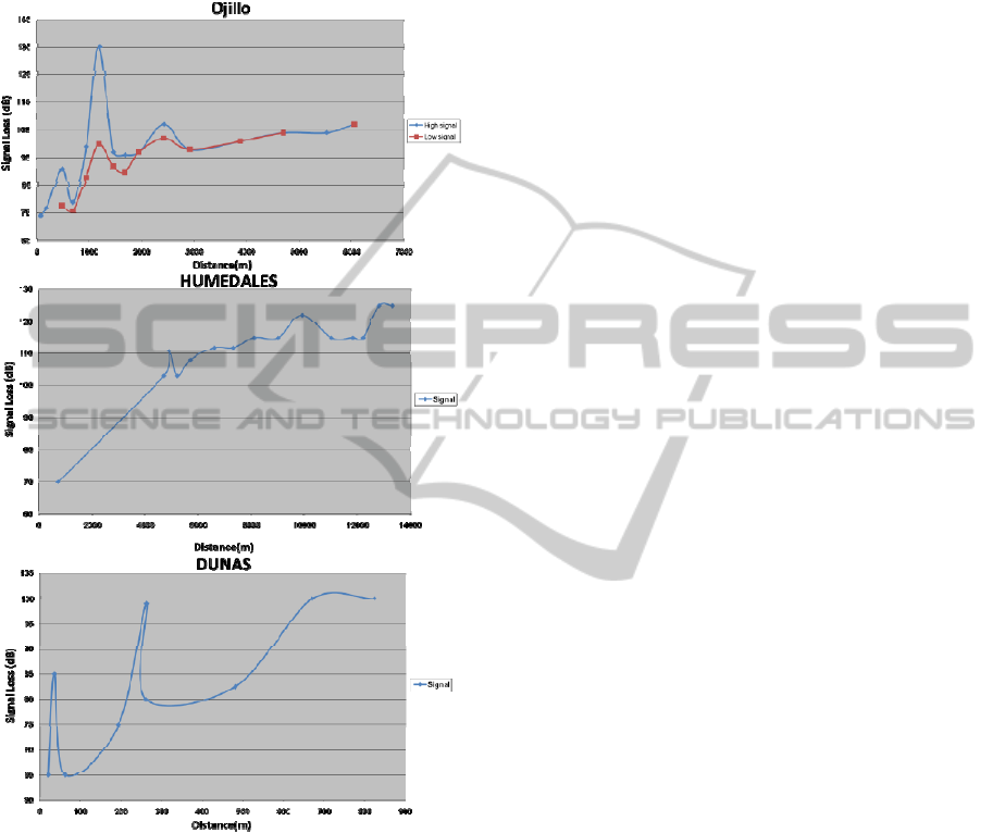
Dunas zone we realized that the signal is lost
immediately when measuring from the tower mote
(pink route), so we moved both XBee motes to
Dunes zone and we obtained around 0.8 Km. Results
of this zone are presented on figure 2 bottom.
Figure 2: Signal reception in dB for Matalascañas route
(blue on map), Humedales (wetlands) (red on map) and
Dunes (purple on map).
5 CONCLUSIONS
This work presents a communications study in a
free-building scenario (Doñana Biological Park).
This study was carried out in various areas of the
park (named above) to test how terrain and weather
conditions changes affect the results. Due to the
thick vegetation of the park, the signal emitted in 2.4
GHz was easily absorbed, reducing link distances
and, therefore, significant results have been undergo
using 868 Mhz transmissions.
The equipment used, with 300mW of power,
reaches distances of several kilometres. In this way,
natural habitat is not contaminated with lots of nodes
through the park (2 or 3 points could cover DBR).
ACKNOWLEDGEMENTS
This work has been in part sustained by the RDB-
ICTS 39/2010 Second Call Access 2009-2010 ICTS-
RBD (http://icts.ebd.csic.es/ListarConvocatoriasActi
on.do)
REFERENCES
Ruedi Haller, Flurin Filli and Stephan Imfeld. 2001.
Evaluation of GPS-technology for tracking mountain
Ungulates: vhf-transmitters or GPS-collars? Tracking
animals with GPS. Springer. ISBN: 0 7084 0643 2
Robert S. Rempel, Arthur R. Rodgers and Kenneth F.
Abraham. 1995. Performance of a GPS Animal
Location System under Boreal Forest Canopy. Allen
Press.
Philo Juang, Hidekazu Oki, et al. Energy-efficient
computing for wildlife tracking: design tradeoffs and
early experiences with ZebraNet. 2002. 10th
international conference on Architectural support for
programming languages and operating systems. Pp
96-107. ISBN:1-58113-574-2
Andrew C. Markham, Andrew J. Wilkinson. 2008.
EcoLocate: A Heterogeneous Wireless Network
Systemfor Wildlife Tracking. Novel Algorithms and
Techniques in: Telecommunications, Automation and
Industrial Electronics, Springer Science, Business
Media B.V.
Scott L. Findholt, Bruce K. Johnson, Larry D. Bryant,
JackW.Thomas, 1996. Corrections for Position Bias of
a LORAN-C Radio-Telemetry SystemUsing DGPS.
NoIhwest Science Vol. 70. No.3.
L. David Mech. 2002. A Critique of Wildlife Radio-
Tracking and its Use in National Parks. A Report to
the U.S. National Park Service. The Raptor Center,
1920 Fitch Ave., University of Minnesota, St. Paul,
MN 55108.
Joseph Allen. 2009. Use of Coded Transmitter Schemes to
Overcome Radio Frequency Spectrum Constraints in
Terrestrial Wildlife Tracking. Report Advanced
Telemetry Systems, Inc., Isanti, MN 55040
Vodafone Group Foundation. Introduction to Tracking
Technology – GPS and GIS. Technologies for
Conservation and Development, www.t4cd.org.
Doñana National Park. UNESCO. 1994. http://whc.
unesco.org/en/list/685
Merrett, G. V., Weddell, A. S., Berti, L., Harris, N. R.,
White, N. M. and Al-Hashimi, B. M. 2008. A Wireless
Sensor Network for Cleanroom Monitoring. In:
Eurosensors, Dresden, Germany.
TECHNICAL VIABILITY STUDY FOR BEHAVIORAL MONITORING OF WILDLIFE ANIMALS IN DOÑANA - An
802.15.4 Coverage Study in a Natural Park
101
