
LOCATION BASED USER MODELING IN ADAPTIVE MOBILE
LEARNING FOR ENVIRONMENTAL AWARENESS
Efthimios Alepis
1
, Maria Virvou
1
and Katerina Kabassi
2
1
Department of Informatics, University of Piraeus, 80 Karaoli & Dimitriou St., 18534, Piraeus, Greece
2
Department of Ecology and the Environment, Technological Educational Institute of the Ionian Islands
Zakynthos, Greece
Keywords: Mobile learning, Environmental informatics, User modelling, Adaptive learning.
Abstract: Recently it has been widely acknowledged that the incorporation of advanced information technologies in
the areas of ecological informatics may provide significant assets towards social environmental awareness.
In this paper we present a sophisticated mobile learning system which offers environmental educational
information to users based on their current geographical location. The system adapts its content according to
the user’s personal characteristics and to the user’s mobile device. The adaptation of the user’s interface is
accomplished through the incorporation of a well known decision making model, namely the Analytic
Hierarchy Process (AHP). The resulting prototype system is called m-AWARE and is targeted to people of
all ages, providing easily accessible information about our environment for environmental awareness
purposes.
1 INTRODUCTION
Environmental informatics is the application of
information technology to environmental science. In
(Rickinson, Lundholm and Hopwood, 2010), it is
stated that the last 4 decades have seen growing
international recognition for the educational
dimensions of environmental and sustainable
development issues. Since the late 1960s,
international statements from organizations such as
the IUCN (International Union for the Conservation
of Nature) (www.iucn.org) and UNESCO (United
Nations Educational, Scientific and Cultural
Organization) (www.unesco.org) have called by
environmental problems to be tackled through
environmental education for all age groups. The
need for prompt and valid information is even
greater nowadays, since we are all witnesses of daily
environmental disasters and of the irreversible
damages to our ecosystem. Environmental disasters
can have an effect on agriculture, biodiversity,
economy and human health. The causes include
pollution, depletion of natural resources, industrial
activity or agriculture.
A remedy against the rapid destruction of our
natural environment due to human activities may lie
at providing easily accessible and comprehensive
environmental data to all the people through the use
of recent technological and scientific achievements.
As it is stated in (Pillmann, Geiger and Voigt, 2006),
in the science sector, a rapidly growing community
conceived new computer applications for decision
making and information exchange in the field of
environmental protection, since environmental
problems in the last decades have resulted in an
increased ecological awareness in Europe.
Ecological informatics (ecoinformatics) is an
interdisciplinary framework for the processing,
archival, analysis and synthesis of ecological data by
advanced computational technology (Recknagel,
2006). According to (Recknagel, 2006),
computational technologies currently considered
being crucial for data archival, retrieval and
visualization in Environmental Informatics include:
Object-oriented data representation to facilitate
data standardization and data integration by the
embodiment of metadata and data operations into
data structures;
Internet and world wide web to facilitate
interactive and online simulation as well as software
and model sharing;
Remote sensing and GIS to facilitate spatial data
visualization and acquisition;
214
Alepis E., Virvou M. and Kabassi K..
LOCATION BASED USER MODELING IN ADAPTIVE MOBILE LEARNING FOR ENVIRONMENTAL AWARENESS.
DOI: 10.5220/0003505302140217
In Proceedings of the 6th International Conference on Software and Database Technologies (ICSOFT-2011), pages 214-217
ISBN: 978-989-8425-76-8
Copyright
c
2011 SCITEPRESS (Science and Technology Publications, Lda.)

Adaptive agents to facilitate adaptive simulation
and prediction of ecosystem composition and
evolution.
In view of the above, in this paper we present a
novel adaptive mobile learning system that
incorporates all the four fore mentioned computation
technologies. The system’s main objective is to use
location based and user modeling information for
environmental awareness purposes. The resulting
system is called m-AWARE, which is the acronym
for “mobile-Adaptive Warnings and Advice for
Resources of the Environment”. More specifically,
in this paper we focus on the application of recent
advances in Information Technology, such as mobile
software engineering, multi-criteria decision
making, adaptive hypermedia and geographic
information systems (GIS) to environmental science.
The proposed theory for the construction of the
multi criteria decision making model is the Analytic
Hierarchy Process (AHP) method. The AHP method
is used as a reasoning mechanism for the
specification of the information that is delivered to
the users through their mobile devices. Each user’s
profile includes information about the specific user
(such as user’s age, user’s educational background,
interests, gender, etc.), as well as information about
the users’ current geographic location. Finally,
information about each user’s personal mobile
device will be also retrieved in order to adapt the
application to the user’s device needs and
limitations. The proposed system will also use
stereotypic information derived from each user’s
given personal information.
The architecture that is used for the
representation of the available data is based on the
Object Oriented model. Object oriented approaches
have been already widely used in software
development environments (Chiu, Lo and Chao,
2009), (Pastor, Gomez, Insfran and Pelechano,
2001). The resulting system is able to process
ecological data and present the appropriate
information to users who own mobile devices based
on their personal profile, where they are (geographic
location in a specified range), and what mobile
device they are using. Accordingly, the
representation of the available ecological
educational information is dynamically adapted to
each user. Finally, the interaction between users and
the application is friendly to a high extent through
the use of pedagogical animated agents.
2 DECISION MAKING MODEL
THROUGH THE ANALYTIC
HIERARCHY PROCESS
AHP is one of the most popular Multi Criteria
Decision Making (MCDM) methods. It has solid
theoretical foundation and objectivity to some
degree. AHP is based on three principles:
decomposition, comparative judgments, and the
synthesis of priorities, and can help decision makers
to develop systematic approaches for a variety of
problems.
The Analytic Hierarchy Process (AHP) (Saaty,
1980) is composed of several previously existing but
unassociated concepts and techniques, such as
hierarchical structuring of complexity, pair wise
comparisons, an eigenvector method for deriving
weights etc. (Jandric and Srdjevic, 2000), (Selly and
Forman, 2001). Based on mathematics and
psychology, the AHP has been extensively studied
and refined over the last decades. It provides a
comprehensive and rational framework for
structuring a decision problem, for representing and
quantifying its elements, for relating those elements
to overall goals, and for evaluating alternative
solutions.
The method consists of the following steps (Zhu
and Buchman, 2000):
Developing a goal hierarchy.
Setting up a pair wise comparison matrix of
criteria.
Ranking the relative importance between
alternatives.
Checking consistency of the comparisons.
Calculating AHP values.
The AHP value is computed using the following
formula:
N
j
jiji
waAHP
1
, for
Mi ,...,3,2,1
where M is the number of alternatives and N is the
number of criteria; a_{ij} denotes the score of the
i^th alternative related to the j^{th} criterion; W_j
denotes the weight of the J^{th} criterion.
Figure 1, illustrates the AHP hierarchy that
results by the application of the AHP’s model to our
system.
The exact weights for the criteria that are used in
our implementation of the AHP model have been
initially specified by the authors. However, a future
empirical study may reveal more accurate values for
the determination of each criterion’s importance.
LOCATION BASED USER MODELING IN ADAPTIVE MOBILE LEARNING FOR ENVIRONMENTAL
AWARENESS
215
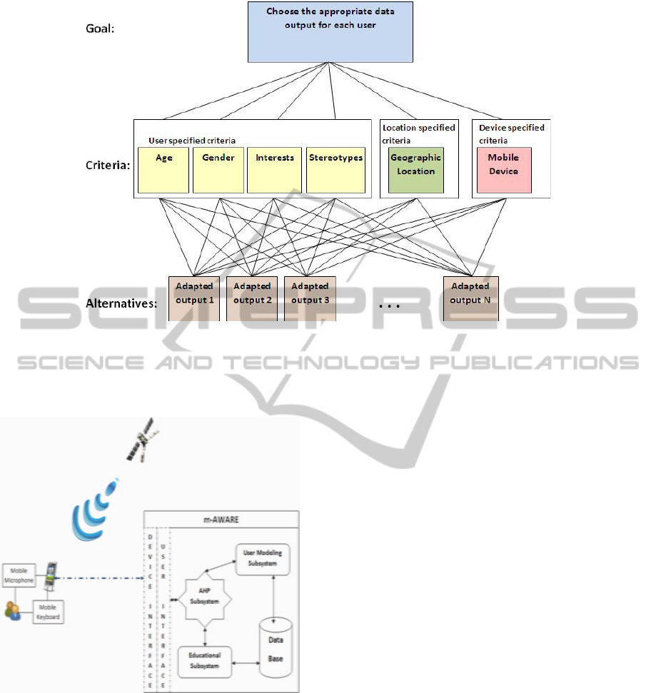
Figure 1: AHP hierarchy in m-AWARE.
3 OVERVIEW OF THE SYSTEM
Figure 2: Architecture of m-AWARE.
In this section, we describe the overall functionality
and features of m-AWARE.
The architecture of m-AWARE consists of the
main educational application, a user modeling
component, a decision making inference mechanism
and a database. Part of the database is used to store
educational data and another part is used to store
data related to user modeling. Accordingly, the
database is also used to store user models and user
personal profiles for each individual user that uses
and interacts with the system, as well as stereotypic
information about user profiles. The system’s
architecture is illustrated in figure 2.
As we can see in figure 2, the students’
interaction can be accomplished either orally
through the mobile device’s microphone, or through
the mobile device’s keyboard. The educational
system consists of three subsystems, namely the user
modeling subsystem, the educating application
subsystem and the subsystem that incorporates the
decision making mechanism. Both the user
modelling subsystem’s data and the educational
subsystem’s data are stored in the main system’s
database, while the decision making subsystem is
responsible for the resulting interface created for
each user during his/her interaction with m-
AWARE. m-AWARE has been developed to operate
on the Android mobile operating system, while as
for future work the authors are planning to provide
implementations for other existing mobile phone
platforms as well. Correspondingly, the system is
programmed using JAVA as a programming
language. This specific programming language is
also compatible with the system’s Object Oriented
structure. Figure 3 illustrates a snapshot of the
operating educational application, where a user is
retrieving environmental information about a
specific geographic location.
ICSOFT 2011 - 6th International Conference on Software and Data Technologies
216
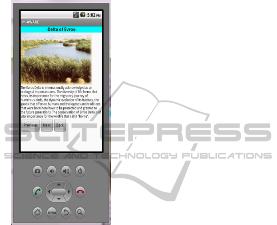
Figure 3: A user is viewing the available information
adapted to his/her profile.
4 CONCLUSIONS AND FUTURE
WORK
Greece, has the tenth longest coastline in the world
at 14,880 km in length, featuring a vast number of
islands (approximately 1400, of which 227 are
inhabited). Eighty percent of Greece consists of
mountains or hills, making the country one of the
most mountainous in Europe. However, continuous
environmental disasters have negative effects on our
country’s agriculture, environment and tourism and
as a result to our economy and human health. A
remedy to such environmental problems may lie in
providing environmental education for all age
groups. In our research, we have aimed in creating a
novel Adaptive Mobile Learning system for
Environmental Awareness. It is in our future plans
to evaluate m-AWARE in order to examine the
degree of its usefulness as an educational tool, as
well as the degree of usefulness and user-
friendliness for the people who are going to use the
educational system.
REFERENCES
Chiu, P.-H., Lo, C.-C. , Chao, K.-M., 2009. Integrating
semantic web and object-oriented pro-gramming for
cooperative design, Journal of Universal Computer
Science, Volume 15, Is-sue 9, Pages 1970-1990
http://www.iucn.org/
http://www.unesco.org/
Jandric, Z. and Srdjevic, B., 2000. Analytic Hierarchy
Process in Selecting Best Groundwater Pond, 31st
International Geological Congress
Pastor, O., Gómez, J., Insfrán, E., Pelechano, V., 2001.
The OO-Method approach for information systems
modeling: From object-oriented conceptual modeling
to automated programming, Information Systems, Vol
26, Issue 7, pp. 507-534
Pillmann, W., Geiger, W. and Voigt, K., 2006. Survey of
environmental informatics in Europe, Environmental
Modelling and Software, Volume 21, Issue 11, Pages
1519-1527.
Recknagel, F., 2006. Ecological Informatics, Springer
Rickinson, M., Lundholm, C., Hopwood, N., 2010.
Environmental Learning: Insights from research into
the student experience, Springer.
Saaty, T., 1980. The Analytic Hierarchy Process:
Planning, Priority Setting, Resource Allocation, ISBN
0-07-054371-2, McGraw-Hill.
Selly, M. S. and Forman, E. H., 2001. Decision by
Objectives, World Scientific Publishing Co.
Zhu, Υ., Buchman, Α., 2000. Evaluating and Selecting
Web Sources as External Information Resources of a
Data Warehouse, The Third International Conference
on Web Information Systems Engineering (WISE'00),
149-160.
LOCATION BASED USER MODELING IN ADAPTIVE MOBILE LEARNING FOR ENVIRONMENTAL
AWARENESS
217
