
WEB-BASED SYSTEM FOR AUTOMATICALLY COLLECTING
INFORMATION ABOUT LOCATIONS OF VOLUNTEER
ACTIVITIES OF CITIZEN GROUPS
Akira Hattori and Haruo Hayami
Department of Information Media, Kanagawa Institute of Technology, Atsugi, Japan
Keywords:
Volunteer activities, Automatic collection, Postal address, Web, Map.
Abstract:
A large number of citizen groups, many of which work in a community setting, publish information about
their missions and activities on their Websites. However, it is difficult to understand where and what types of
activities they do because such information is distributed throughout the Web. We show how citizen groups
are currently using maps on their Websites and propose a system for automatically collecting information
from their Websites about locations of their volunteer activities. Our system selects numerous URLs of citizen
group Websites and extracts information about locations of volunteer activities from each group based on the
content and structure of each page on the site. We developed and evaluated a prototype system and found
that our proposed system has great potential for understanding volunteer activities of citizen groups in a local
community.
1 INTRODUCTION
Recently, citizen groups have been playing an im-
portant role in providing solutions to various needs
of citizens and challenges facing societies worldwide
(Salamon et al., 2003). To conduct their volunteer ac-
tivities more effectively and to strengthen their foun-
dations, it is important for citizen groups to gain the
trust and support of their potential supporters, who are
individuals, governments, and businesses. They are
also working in an era of greater demands, fewer re-
sources, and increased competition. Information and
Communication Technology holds the promise of ad-
dressing these challenges, and many groups publish
information about their missions, activities, and their
results on the Web (Hackler and Saxton, 2007). On
the other hand, many people who want to participate
in or support volunteer activities of citizen groups
search for such information using the Web. This has
led to the Web being an important tool for citizen
groups and their potential supporters to publish and
collect information.
However, because each group publishes informa-
tion on its own Website, general information about
volunteer activities is distributed throughout the Web.
This causes difficulties in understanding where and
what types of activities are done by certain citizen gr-
oups. These difficulties can be overcome by aggre-
gating such information published by these groups on
their Websites. In addition, maps are useful for them
to publish information (Craig and Elwood, 1998).
However, to our knowledge, little is known about how
citizen groups are using maps on their Websites.
Therefore, we show how citizen groups in Japan
currently use maps on their Websites, and propose a
system for automatically collecting information about
locations of volunteer activities from their Websites
by taking such map usage into consideration. With
our system, potential supporters who want to partici-
pate in or support volunteer activities can understand
where and what types of activities are performed by
such groups in an easy-to-understand map. This will
lead to increased citizen involvement and coopera-
tion.
The rest of this paper is structured as follows. In
Section 2, we briefly discuss related work. In Section
3, we show how citizen groups currently use maps
on their Websites. In Section 4, we describe our pro-
posed system, followed by its evaluation and discus-
sion. Finally, we give our conclusion in Section 6.
539
Hattori A. and Hayami H..
WEB-BASED SYSTEM FOR AUTOMATICALLY COLLECTING INFORMATION ABOUT LOCATIONS OF VOLUNTEER ACTIVITIES OF CITIZEN
GROUPS.
DOI: 10.5220/0003336805390546
In Proceedings of the 7th International Conference on Web Information Systems and Technologies (WEBIST-2011), pages 539-546
ISBN: 978-989-8425-51-5
Copyright
c
2011 SCITEPRESS (Science and Technology Publications, Lda.)

2 RELATED WORK
2.1 Citizen Group Websites and Online
Databases
Over the past ten years numerous attempts have been
made to assess how citizen groups use their Websites
using content analysis. Some studies involved eval-
uating such Websites from the viewpoint of commu-
nication and fundraising practices (Kent and White,
2001) (Waters, 2007). There have also been several
studies on how Web 2.0 technologies, such as Weblog
and social networking sites, were being used by citi-
zen groups to advance their missions and programs
(Waters et al., 2009) (Greenberg and MacAulay,
2009). However, as far as we know, how citizen
groups use maps on their Websites has never been ex-
amined. We show such usage based on citizen group
Websites research. A large number of citizen groups
work in a local community setting, and Web mapping
services, such as Google Maps and Yahoo! Maps, are
freely available (Hudson-Smith et al., 2007). Such
mapping services hold the promise of providing an
opportunity for using maps on Websites for citizen
groups, especially, small ones, which generally have
limited financial and human resources. Many groups
are small in Japan. Therefore, it is important to ex-
plore how these citizen groups use maps on their Web-
sites.
A variety of online databases of citizen
groups have been developed by various orga-
nizations on the Web, for example, GuidStar
(http://www2.guidestar.org/), The Chronicle of
Philanthropy (http://www.philanthropy.com/), and
Imagine Canada (http://www.imaginecanada.ca/).
These databases store basic information such as
names, locations of main offices, and missions and
programs, and make it available to the public. Some
databases allow registered groups to update their
information. However, the information stored in
such databases is basic and are typically textual
documents. Therefore, they do not provide an easy
environment to understand where and what types
of activities are performed by citizen groups. In
contrast, our proposed system aggregates location
information of their volunteer activities distributed
on their Websites and puts it onto a map.
2.2 Detection of Geographic Location
Information on the Web
It has long been recognized that there is a large
amount of geographic location information on the
Web. Many Web pages have one or more types of
geographic location information. However, current
search engines often produce results of geograph-
ically unrelated pages for queries containing some
kind of geographic term. Considerable attention
has been on geographic-oriented keyword searches.
Many approaches have been proposed for detecting
geographic location information on the Web (McCur-
ley, 2001), (Amitay et al., 2004), (Clough, 2005), and
(Wang et al., 2005). They identify and extract infor-
mation from Websites from around the world. Jun-
yan et al. (Junyan et al., 2000) discuss how to au-
tomatically estimate the geographical scope of Web
resources. Ahlers and Boll (Ahlers and Boll, 2007)
and Gao et al. (Gao et al., 2006) proposed several ge-
ographically focused crawling strategies for collect-
ing Web pages related to the specified geographic re-
gions. There are also systems for automatically cre-
ating a detailed gazetter (Goldberg et al., 2009) and
(Martins et al., 2009), which is a unified repository
of geographic information, from geographic location
information on the Web. The system developed by
Chen et al. (Chen et al., 2007) visualizes RSS feeds
containing geographic location information on a map.
Current systems, including those mentioned
above, collect geographic location information from
Websites from around the world or specific informa-
tion sources such as the RSS feeds specified by a user.
However, to our knowledgethere is no comprehensive
collection of links to citizen group Websites. There-
fore, it is necessary to find such links from numerous
Websites and to extract information about locations
of volunteer activities from each group, and current
systems are inadequate for doing this. Our system is
characterized by selecting a Website for each citizen
group and extracting information about locations of
volunteer activities from the site based on the group’s
basic information, content, and structure of each page
on the site.
3 HOW CITIZEN GROUPS
CURRENTLY USE MAPS
ON THEIR WEBSITES
3.1 Methodology
Maps are useful for citizen groups working in a com-
munity setting to publish information. To understand
how citizen groups currently use maps on their Web-
sites, we examined two questions before designing
our system: (1) What types of maps are used by these
groups? and (2) What kind of information do they
WEBIST 2011 - 7th International Conference on Web Information Systems and Technologies
540
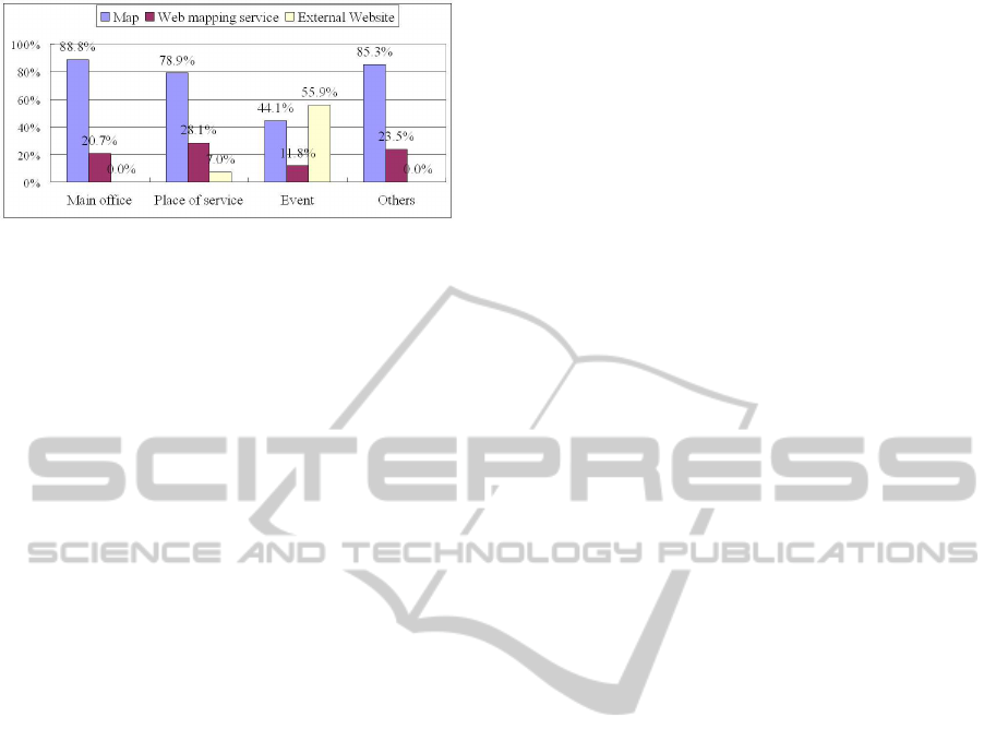
Figure 1: Map types for each type of map content.
publish using these maps? We refer to questions (1)
and (2) as ”map type” and ”map content”, respec-
tively.
Citizen groups were drawn from ”npo hiroba”,
which is one of the largest online databases in Japan
and is available at http://www.npo-hiroba.or.jp/. We
selected groups that have main offices in Kanagawa
and have Websites. We analyzed the Websites of 297
groups from June 6 to 23, 2010.
3.2 Results
The map content of citizen group Websites are di-
vided into three purposes: for showing the locations
of their main offices, locations of their programs and
services they regularly provide, and sites of special
events they hold. Figure 1 illustrates what types of
maps are used for each type of the map content. Most
of the maps for showing the main offices are hand
drawn using word processing programs and map cre-
ation tools. About 15% of the groups we examined
use Web mapping services, and many of them do this
to show the locations of their main offices and their
programs and services. About one-tenth of the groups
use maps to show their special events, and about half
of them are links to external Web pages containing
maps.
3.3 Discussion
About half the groups we examined use maps to show
the locations of their main offices and the places
where they provide their programs and services. One
of the purposes of using a map on a Website is to show
locations to visitors. For this purpose, many groups
are likely to use hand drawn maps containing only
landmark buildings and large intersections rather than
detailed maps. However, because each group man-
ages its own Website, information about their volun-
teer activities are distributed over many sites through-
out the Web. This causes difficulties in understand-
ing where and what types of activities are performed
by citizen groups. It is effective for those who want
to search for citizen groups on the Web to aggregate
these two types of geographic location information
about their volunteer activities distributed throughout
the Web into a map. A street or postal address is the
most common way to refer to a location (Himmel-
stein, 2005). In addition, addresses are found on many
of the groups’ Web pages containing maps showing
the locations of their main offices and programs and
services. Thus, our proposed system automatically
collects addresses as information about locations of
volunteer activities done by citizen groups from their
Websites and puts this information onto a map.
4 AUTOMATICALLY
COLLECTING LOCATIONS
OF VOLUNTEER ACTIVITIES
4.1 Outline of Our System
As mentioned above, there is no collection of links
to citizen group Websites, and postal addresses are
found on many of the groups’ Web pages containing
maps. Thus, our system has two main functions. One
is to find the addresses (URLs) of such Websites from
numerous sites throughout the Web, and the other is
to extract postal addresses from these Websites.
The overall flow of our system are as follows. (1)
The system collects basic information about citizen
groups such as names, location of main offices, and
mission and activity areas from an online database
of them on the Web, attaches geographic coordinates
(latitude and longitude) corresponding to the location,
and stores the information in our system’s database,
which is referred to as the basic information database.
(2) Next, it collects URLs of citizen group Websites
using a Web search engine and selects one for each
group. (3) Then, it extracts information about lo-
cations of volunteer activities, which is a postal ad-
dress in our system, and maps used from each Web-
site and stores the information in two of our system’s
databases, referred to as the first location informa-
tion database of volunteer activities and map meta-
data database, respectively. The system attaches ge-
ographic coordinates corresponding to the extracted
address as well. (4) Then it applies some filters to
the extracted addresses based on the structure of the
Web page such as the address and presence or absence
of a map, and stores the resulting addresses in an-
other database of our system, referred to as the second
location information database of volunteer activities.
(5) Finally, it shows geographic location information
stored in the databases on a map using a Web mapping
WEB-BASED SYSTEM FOR AUTOMATICALLY COLLECTING INFORMATION ABOUT LOCATIONS OF
VOLUNTEER ACTIVITIES OF CITIZEN GROUPS
541

service. The following section explains each step in
detail.
4.2 System Functions
4.2.1 Collecting Basic Information
Our system uses the ”NPO portal” site as the on-
line database of citizen groups to collect basic in-
formation such as their names and locations of
main offices. The site is managed by the Cabi-
net Office of Japan and available at http://www.npo-
homepage.go.jp/portalsite.html. The system searches
for citizen groups on the site by location of their main
offices, and parses the resulting HTML document
to collect basic information about the citizen groups
linked from the document. After that, it converts the
location of the main office contained in the basic in-
formation to geographic coordinates, which are lati-
tude and longitude, using the geocoding functionality
of a Web mapping service. Finally, it stores the infor-
mation in the basic information database.
4.2.2 Collecting and Selecting URLs of Citizen
Group Websites
To collect URLs of citizen group Websites, our sys-
tem first puts their names and ”NPO, or ’specified
nonprofit corporation’”, as keywords in the query of a
Web search engine, which is the Google search in our
system. The system uses the top three search results
as candidates for the URL of each group’s Website.
Then, it applies the following filters to these candi-
dates:
1. If more than two URLs have the same host and a
path starting with the same directory of the server,
they are regarded as indicating an online database
of citizen groups and eliminated from the candi-
dates. They all start with ”scheme://host/path/.”
2. If one of the path elements of a URL is an e-
mail address, a postal code (three-digits hyphen
four-digits in Japan) or a telephone number (three-
digits hyphen three-digits hyphen four-digits, etc.
in Japan), it is regarded as indicating an online
database and eliminated from the candidates.
3. If one of the path elements of a URL is ”bbs”,
which is short for bulletin board system, or ”ml”,
which is short for mailing list, it is eliminated
from the candidates. This is because many bul-
letin board systems and mailing lists are used to
communicate among members and supporters of
citizen groups.
4. If the title of the Website at a URL for a group do
not contain the group’s name, the URL is elimi-
nated from the candidates.
After applying these filters, our system selects the
URL with the highest ranking for each group as its
Website.
4.2.3 Extracting Addresses and Maps from
Websites
First, to extract addresses and maps from citizen
group Websites, our system searches within the Web-
site of the URL selected for each group using a Web
search engine. Then, the system executes the follow-
ing process for each of the resulting Web pages.
As a preprocessing to extract addresses and maps
from each page, our system converts the HTML doc-
ument to XML with HTML Tidy and loads it as a tree
of nodes, which is commonly referred to as a docu-
ment object model (DOM) tree. After that, our system
traverses the tree from its root.
When our system moves to the text node, it ex-
tracts a set of addresses from the node’s value based
on regular expression matching of an address and
converts each extracted address to geographic coordi-
nates using the geocoding functionality of Web map-
ping services. If an address is convertedto geographic
coordinates, it is stored in the first location informa-
tion database of volunteer activities together with the
coordinates. The first database also stores the path ex-
pression to traverse the tree from its root down to the
processing text node. Moreover, it stores the values
of all text nodes contained in a sentence block. As
shown in Figure 2, we defined a sentence block as a
node corresponding to an HTML block element, such
as <DIV>, <TABLE>, <P>, <BODY>, which is
first encountered in moving up the tree from the text
node towards its root. If the value of a text node is a
sentence, our system does not extract any addresses.
To determine whether a value is a sentence or not, the
system uses punctuation marks.
On the other hand, for extracting maps, our system
checks if a node satisfies either of the following con-
ditions based on the characteristics of the maps used
on citizen group Websites.
1. When the name of the processing node is ”img”,
which is an <IMG> tag, and the value of the src
attribute contains a word like ”map” or ”tizu” in
the file name of the image. ”Tizu” means ”map”
in Japanese.
2. When it is ”a” or ”iframe”, which are <A> and
<IFRAME> tags, respectively, the value of the
href or the src attribute references a Web mapping
service with a specific location.
WEBIST 2011 - 7th International Conference on Web Information Systems and Technologies
542
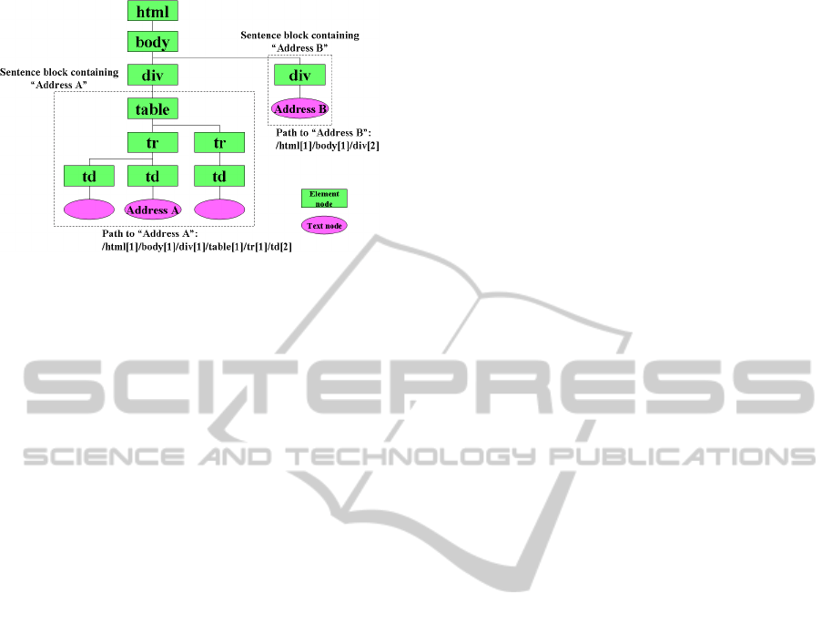
Figure 2: Example of sentence block.
When a map is found, our system stores the map’s
metadata in the map metadata database. The metadata
consists of the value of an href or a src attribute and
the path expression to traverse the tree from its root to
the node containing the map.
4.3 Address Filtering
Our system applies filters to addresses stored in the
first location information database of volunteer activ-
ities, and stores the resulting ones in the second one.
The filters are as follows.
1. When none of addresses extracted from a Web-
site of a citizen group correspond with the loca-
tion of its main office stored in the basic informa-
tion database, it is assumed that the selected URL
is not the one for the group, namely, the correct
URL is not selected. In this case, our system does
not store all the addresses extracted from the Web-
site in the second database.
2. When there are different addresses at the same po-
sition in each tree structure for many pages on a
citizen group Website, it is assumed that its URL
selected using our system is an online database. In
our system, the same position means that the path
expression to a text node containing an address in
a Web page on a Website is the same as that in an-
other page containing the address of the Website.
In this case, our system does not store all the ad-
dresses extracted from the Website in the second
database.
If a page containing an address also has a map
after applying these filters, our system stores the ad-
dress in the second database. Therationale is based on
the fact that addresses are found on many pages with
maps on the citezen group Websites we examined, as
shown in Section 3.
There are also groups that do not use maps on
their Websites. Therefore, when the text values within
the sentence block corresponding to an address con-
tains date expressions such as ”every week” or ”every
month” and words indicating the day of the week, our
system stores the address in the second database as
well. We emphasize regular activities before irregu-
lar ones, such as a seminar, and set such words and
expressions as a condition for storing addresses in the
second database.
However, when the same address appears at the
same position in each tree structure for many pages on
a citizen group Website, it is assumed that the address
is contained in the common menu, header, or footer of
pages on the Website. If a page contains two or more
addresses, our system does not store those appearing
at such positions in the second database.
4.4 Prototype System
We developed a prototype system to collect informa-
tion about locations of volunteer activities for 2658
citizen groups in Kanagawa Prefecture, Japan. The
prototype displays the locations of the main offices
stored in the basic information database and the ex-
tracted addresses from citizen group Websites stored
in the second location information database of volun-
teer activities on a map using Google Maps. Users
can search for citizen groups by their names, activ-
ity areas, and missions. To help users do this, the
prototype performs morphological analysis of citizen
group missions in the basic information database and
displays a weighted list of the words in the missions
in accordance with the frequency of their appearance.
Each word in the list is a hyperlink that leads to a
search by missions. Figure 3 illustrates a search for
”Sound nurturing of youth” in the activity area and
”child-raising” in the mission. In this figure, extracted
addresses from the Websites of the resulting citizen
groups are shown on the map.
5 EVALUATION
AND DISCUSSION
5.1 Accuracy of Selecting URLs
of Citizen Group Websites
We first evaluated the accuracy of selecting URLs of
citizen group Websites. We compared URLs selected
with our proposed system with those of the Websites
we examined to understand how citizen groups cur-
rently use maps. Because 5 of the examined 297
groups had not been stored in the ”NPO portal” site,
we compared the URLs of 292 group Websites. As
WEB-BASED SYSTEM FOR AUTOMATICALLY COLLECTING INFORMATION ABOUT LOCATIONS OF
VOLUNTEER ACTIVITIES OF CITIZEN GROUPS
543
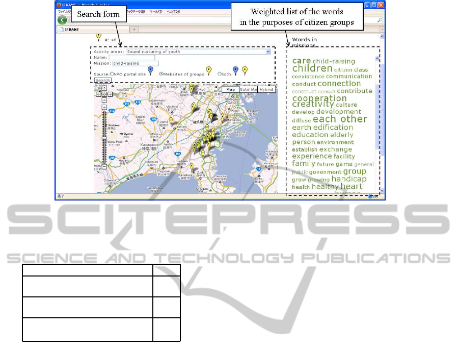
Figure 3: Map displaying search results.
Table 1: Result of selecting URLs of citezen group Web-
sites.
Correct or incorrect #
Number of URLs
our system correctly selected
168
Number of URLs
not correctly selected
61
Number of citizen groups
that selected no URL
63
listed in Table 1, the URLs of Websites for 168 out of
the 292 groups were correctly selected. The recall ra-
tio was 57.5% and the precision ratio was 73.4%. The
reasons why our system could not select the correct
URL are as follows.
• There were groups with the same or almost the
same name.
• A Website was moved to another server.
• A Weblog, not a Website, of a citizen group was
selected.
We need to solve these problems to improve the
recall ratio.
For all 2658 citizen groups, our system selected
URLs of Websites for 1271 groups. Taking the pre-
cision ratio, which is 73.4%, into consideration, the
URLs of Websites for about 930 groups could be
correctly selected. According to the research con-
ducted by the Cabinet Office of Japan, 59.0% of cit-
izen groups, all of which are specified as nonprofit
corporations in Japan, have their own Websites. Con-
sequently, in Kanagawa Prefecture, about 1570 of the
2658 groups have their own Websites, and it can be
assumed that the 930 groups will show a precision ra-
tio of 59.5%. This is a promising result because there
is no collection of links to citizen group Websites.
5.2 Evaluation of Address Extraction
We evaluated address extraction performance of our
proposed system. We used the 292 citizen groups
discussed in the previous section. Our system cor-
rectly selected URLs of Websites for 168 groups as
discussed in the preceding section, and the system
stored addresses from 148 of the 168 group Websites
in the first database. Locations of main offices were
extracted from 106 of the 148 Websites and other lo-
cations were from 117 Websites. On the other hand,
the system could not select the correct URLs of Web-
sites for 61 groups and stored addresses from 37 out
of the 61 Websites in the first database. Locations of
main offices were extracted from 14 of the 37 Web-
sites and other locations were from 31 Websites.
In addition, the system extracted maps from 111
of the 168 group Websites. On the other hand, it ex-
tracted maps from 17 of the 61 group Websites.
One of the simplest filters for storing addresses in
the second database is one in which at least one of the
addresses extracted from a Website of a citizen group
corresponds with the location of the group’s main of-
fice stored in the basic information database. Thus,
to evaluate our proposed system of storing addresses
in the second database, we compared our system in
which a filter of a Web page containing an address
has maps or date expressionswith one in which a filter
was not applied. We refer to these two filters as pro-
posed and simple, respectively. The results are listed
in Table 2.
With the simple filter, our system stored addresses
WEBIST 2011 - 7th International Conference on Web Information Systems and Technologies
544

Table 2: Number of citizen groups stored in first and second databases.
Location of main office (a) Other locations (b) Address (a or b)
Correct, or
incorrect
Correct
(%, N=168)
incorrect
(%, N=61)
Correct
(%, N=168)
incorrect
(%, N=61)
Correct
(%, N=168)
incorrect
(%, N=61)
First database 106(63.1%) 14(23.0%) 117(69.6%) 31(50.8%) 148(88.1%) 37(60.7%)
Second Proposed 49(29.2%) 3(4.9%) 38(22.6%) 2(3.3%) 63(37.7%) 4(7.5%)
database Simple 101(60.1%) 14(23.0%) 70(41.7%) 8(13.1%) 101(60.1%) 14(23.0%)
extracted from Websites for 101 out of 148 groups,
of which Website URLs were correctly selected, in
the second database, which was 60.1%. On the other
hand, with the proposed filter, the system stored ad-
dresses from 63 Websites, which was 37.7%. For the
37 groups in which the Website URLs were not cor-
rectly selected, our system stored addresses from 14
Websites in the second database with the simple filter,
which was 60.7%. With the proposed filter, however,
our system stored addresses from 4 Websites, which
was 7.5%. URLs of 3 out of the 4 Websites were pre-
fixed with ”www” to each of the corresponding cor-
rect URLs or vice versa, and their IP addresses were
the same. Thus, with the proposed filter, very few ad-
dresses were stored from Websites that were not cor-
rectly selected in the second database.
5.3 Potential of Our System
We received the following positive comments from
five citizen group members who participated in a pre-
liminary evaluation.
• This system is practical because a map is intu-
itively understandable and makes it possible to or-
ganize information into each location.
• This system is useful when we are asked for ad-
vice, for example, to send direct mail to groups
working to improve the welfare of citizens.
• We can use the system when we want to do some-
thing for the local community but we do not have
enough resources such as people and skills.
• I have never seen such a system before. This sys-
tem can be used as an information source since we
can see how many groups are in an area.
• Plotting locations of volunteer activities on a map
is easy-to-understand because they are seen.
We also received the following suggestions.
• It is necessary for activities, such as for the envi-
ronment and urban development, to be in different
colors on the map.
• I am interested in a map showing locations of citi-
zen groups; however, it is more important to show
their activities.
• In Japan, sometimes a location of a main office
is one’s home. Therefore, it will be necessary to
provide a map with that in mind.
• The system can be improved when local informa-
tion, such as shopping and sightseeing, is com-
bined with information about volunteer activities
on the map.
• I’m afraid that the system might cause informa-
tion overload, and it may be difficult to keep the
information updated.
• When a location changes through time, for exam-
ple event information, it may be difficult to under-
stand the change on the map.
These positive comments indicate that our system
with a function for collecting locations of volunteer
activities done by citizen groups from their Websites
has great potential for understanding their volunteer
activities in a local community. Although requiring
a combination of an address and map decreases the
recall ratio of address extraction, it is effective for
the condition that in Japan, sometimes a location of
a main office is one’s home. This is because one of
the purposes of using a map on a Website is to show a
location to visitors. On the other hand, it was pointed
out that information about volunteer activities them-
selves was not adequately shown. Thus, we need
to develop methods for collecting more information
from citizen group Websites and to display and en-
able one to search for such information on a map.
6 CONCLUSIONS
We showed how citizen groups in Japan currently use
maps on their Websites, and proposed a system for
automatically collecting locations of their volunteer
activities from their Websites. We also developed and
evaluated a prototype system and found that collect-
ing such locations and displaying them on a map has
great potential for understanding volunteer activities
of citizen groups in a local community.
Future work includes enhancing functionality of
our system based on the results from evaluating the
WEB-BASED SYSTEM FOR AUTOMATICALLY COLLECTING INFORMATION ABOUT LOCATIONS OF
VOLUNTEER ACTIVITIES OF CITIZEN GROUPS
545

prototype system. We also need to evaluate our sys-
tem based on a broader implementation test. Further-
more, it is important to see how the system will have
an effect on citizen group Websites and their activi-
ties.
REFERENCES
Ahlers, D. and Boll, S. (2007). Geospatially focused web
crawling. Datenbank-Spektrum, 7(23):3–12.
Amitay, E., Har’El, N., Sivan, R., and Soffer, A. (2004).
Web-a-where: geotagging web content. In Proceed-
ings of the 27th annual international ACM SIGIR con-
ference on Research and development in information
retrieval, pages 273–280.
Chen, Y., Fabbrizio, G. D., Gibbon, D., Jana, R., Jora, S.,
Renger, B., and Wei, B. (2007). Geotracker: Geospa-
tial and temporal rss navigation. In Proceedings of
the 16th international conference on World Wide Web,
pages 41–50.
Clough, P. (2005). Extracting metadata for spatially-aware
information retrieval on the internet. In Proceedings
of the 2005 workshop on Geographic information re-
trieval, pages 25–30.
Craig, W. J. and Elwood, S. A. (1998). How and why
community groups use maps and geographic informa-
tion. Cartography and Geographic Information Sys-
tems, 25(2):95–104.
Gao, W., Lee, H. C., and Miao, Y. (2006). Geographi-
cally focused collaborative crawling. In Proceedings
of the 15th international conference on World Wide
Web, pages 287–296.
Goldberg, D. W., Wilson, J. P., and Knoblock, C. A. (2009).
Extracting geographic features from the internet to au-
tomatically build detailed regional gazetteers. Interna-
tional Journal of Geographical Information Science,
23(1):93–128.
Greenberg, J. and MacAulay, M. (2009). Npo 2.0? explor-
ing the web presence of environmental nonprofit orga-
nizations in canada. Global Media Journal - Canadian
Edition, 2(1):63–88.
Hackler, D. and Saxton, G. D. (2007). The strategic use
of information technology by nonprofit organizations:
Increasing capacity and untapped potential. Public
Administration Review, 67(3):474–487.
Himmelstein, M. (2005). Local search: The internet is the
yellow pages. Computer, 38(2):26–34.
Hudson-Smith, A., Milton, R., Batty, M., Gibin, M., Lon-
gley, P., and Singleton, A. (2007). Public domain
gis, mapping & imaging using web-based services. In
Third International Conference on e-Social Science.
Junyan, D., Luis, G., and Narayanan, S. (2000). Computing
geographical scopes of web resources. In VLDB ’00:
Proceedings of the 26th International Conference on
Very Large Data Bases, pages 545–556.
Kent, M. L. and White, W. J. (2001). How activist orga-
nizations are using the internet to build relationships.
Public Relations Review, 27(3):263–284.
Martins, B., Manguinhas, H., Borbinha, J., and Siabota, W.
(2009). A geo-temporal information extraction ser-
vice for processing descriptive metadata in digital li-
braries. e-perimetron, 4(1):25–37.
McCurley, K. S. (2001). Geospatial mapping and naviga-
tion of the web. In Proceedings of the 10th interna-
tional conference on World Wide Web, pages 221–229.
Salamon, L. M., Sokolowski, S. W., and List, R. (2003).
Global Civil Society: An Overview. Center for
Civil Society Studies, Institute for Policy Studies, The
Johns Hopkins University, Baltimore, MD, USA.
Wang, C., Xie, X., Wang, L., Lu, Y., and Ma, W.-Y. (2005).
Detecting geographic locations from web resources.
In Proceedings of the 2005 workshop on Geographic
information retrieval, pages 17–24.
Waters, R. D. (2007). Nonprofit organizations’ use of the
internet: A content analysis of communication trends
on the internet sites of the philanthropy 400. Nonprofit
Management and Leadership, 18(1):59–76.
Waters, R. D., Burnett, E., Lamm, A., and Lucas, J.
(2009). Engaging stakeholders through social net-
working: How nonprofit organizations are using face-
book. Public Relations Review, 35(2):102–106.
WEBIST 2011 - 7th International Conference on Web Information Systems and Technologies
546
