
THE DIGITAL PATHFINDER
A Plug-and-Play Approach to Local History Instruction in the Field
Ron Coleman, Jeff Bass, Chris Pryslopski, James Johnson
Marist College, Poughkeepsie, New York, U.S.A.
Don Fraser, Melodye Moore
Staatsburgh State Historic Site, Staatsburg, New York, U.S.A.
Keywords: Electronic mobile guide, GPS, Digital humanities.
Abstract: The Digital Pathfinder is an open source “plug-and-play” mobile electronic guide in field trials as an
interdisciplinary project in the Hudson River Valley National Heritage Area. This paper introduces the
project, its motivations, operational, instructional, and technical facets, and experimental results.
1 INTRODUCTION
The Hudson River Valley, beginning 45 km north of
New York City, is home to the largest concentration
of nationally recognized historic places in the United
States. In 1996 the U.S. Congress designated this
region as a National Heritage Area as “the landscape
that defined America” (Clark, 2002). The
Staatsburgh State Historic Site in Staatsburg, New
York, is but one of the sites in the Hudson River
Valley National Heritage Area (HRVNHA). It has
an existing landscape architecture tour that was
previously offered by appointment only and
remained largely unavailable to the 60,000 people
who enjoy the site’s grounds each year. The Digital
Pathfinder is a mobile electronic guide. The project
is an interdisciplinary collaboration motivated by a
perceived opportunity to provide greater public
access to local history resources starting with the
landscape tour at Staatsburgh as the model for
potential replication elsewhere.
Unlike related apps, the Digital Pathfinder was
not designed for casual use in urban environments.
Instead, it has been developed for more pastoral
settings such as estates, graveyards, cemeteries,
nature preserves, etc. which perhaps because of their
remoteness and lack of Internet access have received
little attention in efforts to apply mobile guide
technology. However, the relative quiet of these
venues offers unique instructional and immersive
opportunities that are generally impractical in
metropolitan areas (Yost, 2006). While some users
will be “traditional” visitors, we anticipated other
individuals who are not tourists, namely, teachers,
students, researchers, and others (e.g., hikers,
campers, dog walkers, joggers, site employees, etc.).
The thematic nature of the “plugins” (i.e., the
site-specific/instructional content) has been designed
by humanities scholars and subject matter experts in
close partnership with media artists and computer
scientists. Thus, the deployment in the field is more
like an on-location history tutor and less like a
tourist application. For a synopsis, see the YouTube
video, “The Gilded Age Meets the GPS Age in
Staatsburgh,” (Bass, et al., 2010).
In the remainder of this paper we review related
work, instructional facets, the operational and
technical designs, and the field trial experiments
which may be useful for others seeking to replicate
our results and/or benefit from the anecdotal and
statistical data we’ve gathered. We conclude with a
discussion of the open source and future activities.
2 RELATED WORK
Kenteris, et al. (2010) study several electronic
mobile guide projects and find that most have
navigational maps, positioning methods, and require
constant network connection to access online map
services and other functions like “friend finding,”
ticket eservices, group messaging, etc.
237
Coleman R., Bass J., Pryslopski C., Johnson J., Fraser D. and Moore M..
THE DIGITAL PATHFINDER - A Plug-and-Play Approach to Local History Instruction in the Field.
DOI: 10.5220/0003332402370245
In Proceedings of the 3rd International Conference on Computer Supported Education (CSEDU-2011), pages 237-245
ISBN: 978-989-8425-49-2
Copyright
c
2011 SCITEPRESS (Science and Technology Publications, Lda.)
Unfortunately, this network-bound approach may
incur “phone minutes” or other charges; slow
performance; complicate the software architecture,
and consume more battery power which shortens the
operational runtime in the field. They also perform
unreliably where there is limited network service or
fail entirely if there is no network service which is
often the case in pastoral settings.
The Digital Pathfinder has navigational maps
and GPS positioning but it does not require network
access Smith, 2006; Jones and Dharbriya, 2007;
Coleman 2008b). It does not offer social networking
or similar services. Instead it is completely self-
contained. For this reason the app is perhaps not as
flexible as many of those in Kenteris, et al. (2010)
but then historic sties by their nature don’t change
very frequently. Consequently on balance network
access offers little advantage in the field. In view of
the diversity of our target audience, we opted for an
implementation that helps simplify the user
interface, facilitate deployment logistics, and
improve and/or extend the operational runtime and
reliability.
Kenteris, et al (2010) furthermore indicates most
mobile guides are unique to the platform in which
they are developed because of the absence of
standards and fragmentation in the mobile
marketplace. The Digital Pathfinder sidesteps these
issues through reusability which is the basis for
“plug-and-play.” Namely, it separates site-
specific/instructional content and the reusable
software framework which interprets the plugin
properties. While the plugin format is nonstandard, it
may be converted to a standards-based format
should one emerge or become necessary for future
compliance.
Finally, the systems in Kenteris, et al (2010)
appear to target casual tourists in cities. The Digital
Pathfinder was not designed for metropolitan area
deployment. Instead it emphasizes conveying in-
depth humanities themes using dramatic, rich media
presentations that are mainly practical in more
bucolic settings like those in the HRVNHA and
many other places in the U.S. and internationally.
This does not rule out urban or even suburban
applications but these were not within the scope of
our requirements.
Rossetti (2008) surveys efforts that have sought
to exploit themed location-based learning (Epstein,
2008; Dieterle, Deaded, and Shrier, 2007; Raessens,
2007; Schmidt-Belz, et al, 2002; Stark, et al, 2007).
Rossetti (2008) concludes that the designs differ
mainly in the emphasis each puts on functional
goals, which Abowd, et al (1997) categorized as
cartographer, navigator, librarian, and messenger.
The Digital Pathfinder incorporates these functional
goals plus innovations not anticipated by Abowd, et
al, for instance, the surveyor, marketeer, and master
of ceremonies (M.C.) which we discuss below.
3 FIELD TRIALS
The field trials are a series of experiments the
purpose of which is to gather data about the
application and testers. Individuals who participate
in the experiment contribute to our understanding of
the project in a manner that is only possible by
deploying the application in the target environment
where we can observe both operational and technical
parameters which we describe in section 5.
In exchange for their time and help, participants
receive information about landscape architecture in
general, the historical landscape design at
Staatsburgh, the Milles, their neighbours, and the
surrounding town.
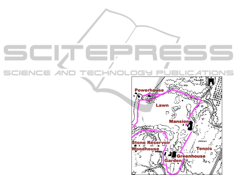
Figure 1: Staatsburgh landscape tour.
The Staatsburgh site is more than 1,600 acres. A
partial map of the property comprising roughly 100
acres is shown in the figure above with some of the
landmarks and an overlay of the landscape
architecture tour which is approximately 2.6 km in
length. The guided tour walkway consists of lawn,
partially paved and gravelled carriage roads, and
wooded trails.
3.1 Experimental Design
The basic unit of the experimental design is a “visit”
in which the participant borrows the PDA at the
CSEDU 2011 - 3rd International Conference on Computer Supported Education
238
Staatsburgh gift shop and takes the guided tour. A
“trial” is a series of visits using a version of the
plugin and the reusable software. The software is
programmed to collect survey and usage data
directly from the user in the field. In fact, this
capability is one of the unique features as we explain
further in section 4. We also collect data of a more
anecdotal nature through informal observations of
and discussions with participants. Finally, data also
comes to the project through online enhancement
requests, reviews, and bug reports that are input
online at open source code repository (Geoplicity,
2010).
3.2 Trials
In general, the field trials represent a staged roll-out
of the application to increasingly larger audiences of
participants. In our opinion, the earlier field trials are
more important even though they encompass fewer
visitors. We suggest this because the opportunity
value of finding and resolving flaws and significant
issues at the outset is greater compared to later
phases.
Trial 0 involves team members other than
programmers but in close consultation with them
using the PDA in the field. The objective is to
identify and fix mainly technical bugs in the plugin
or software. This phase was completed in August
2010.
Trials 1 and 2 consist of visits by third parties
not formally associated with the project such as
faculty members, students, and others. The objective
is to identify any technical bugs but also to get usage
feedback about the plugin directly from the visitor
and as close to real-time experience as possible.
Trial 3, the final phase, consists of volunteers
from the general public.
We completed Trial 1 and Trial 2 in October
2010. We report our findings in section 8.
We expect to initiate Trial 3 which will be
ongoing through spring of 2011. We plan to
complete Trial 3 by June 2011.
4 HOW IT WORKS
This section provides an overview and suggests
through informal use cases and actual screenshots
how the app works from the user’s perspective.
4.1 Running the App
The user launches the app, the pilot implementation
of which runs on an HTC P3470, an unlocked cell
phone running Microsoft Windows Mobile 6. From
the start menu, the app presents the splash screen.
Figure 2: Splash screen.
The user presses “BYE” to exit or
“CONTINUE” to go to the main touch screen as
shown in the figure below.
Figure 3: Main screen.
The user has the option to select different tours
of different lengths and number of stops (see section
5.1). The user can select the language option and
toggle if they are starting at the beginning of the tour
or roaming the grounds serendipitously. The other
tabs provide additional information about the tour
and its configuration, featured events, and
information about the plugin and software.
The user presses “Bye” to quit and “Go!” to start
at which point the screen in the figure below pops
forward.
THE DIGITAL PATHFINDER - A Plug-and-Play Approach to Local History Instruction in the Field
239
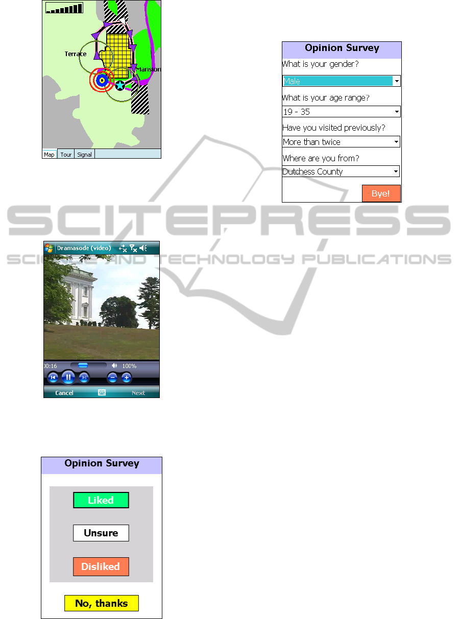
Figure 4: Navigation screen.
This screen shows the navigation map with the
user’s geospatial position, tour path, and landmarks
which activate dramatic episodes or “dramasodes,”
short videos with dramatic readings by actors.
Figure 5: Mills Mansion dramasode.
After each dramasode, the system queries the
user through a functional unit called “Back Talker.”
Figure 6: Back Talker survey.
At the end of the tour, or when the user quits,
Back Talker presents a demographic survey as
shown in the screenshot below.
Figure 7: Back Talker demographic survey.
As the reader may find, the user interface is
fairly straightforward with relatively few actions the
user initiates except, of course, the “embodied” ones
to walk the indicated paths on the display.
5 THEORY OF OPERATION
The Digital Pathfinder was developed as a reusable
means to convey historical information and enrich
the visitor’s experience at sites like Staatsburgh in
the HRVNHA. In general the application is
conducive to rural or pastoral settings where the
relative remoteness and quiet means the dramasodes
can be appreciated outdoors and unobtrusively. To
entertain the user at specific locations and times we
also introduced period music, in this case, ragtime
recordings of Scott Joplin (Berlin, 1996). The
appreciation of these short soundtracks also benefit
from bucolic tranquillity.
5.1 The Matrix
The theory of operation depends on the matrix, M:
M: S
×
H
(1)
where S is a collection of geospatial landmarks or
“stops” related to humanities themes, H. Each cell,
M[i, j]
, is an estimate of the amount of content for a
given theme, H
j
, at stop, S
i
. Thus, when the user
encounters S
i
in the field, the device interactively
retrieves zero or more dramasodes tagged with
theme, H
j
. For instance in the case of Staatsburgh, if
the user is interested in understanding leisure of the
CSEDU 2011 - 3rd International Conference on Computer Supported Education
240

gilded age, when the user arrives at the mansion
landmark, those dramasodes linked to the mansion
and related to gilded age leisure will be retrieved
from the device’s storage and presented interactively
to the user. This gives rise to a multi-layered
presentation that allows the user to specify the focus
of learning at the outset.
An example of the themes matrix is shown in the
table below for Staatsburgh.
Table 1: Themes matrix.
Theme
(H
j
)
Stop (S
j
)
1.MA 2.WF 3.GC 4.GH
1. AA 4 3 1 3
2. AI 1 4 1 5
3. IM 1 -- 2 2
4. LA 3 2 2 4
5. LE 1 1 -- 2
6. TE 1 3 3 3
7. TR 2 2 -- --
8. SC 2 1 1 2
The table below contains the themes (1-8).
Table 2: Major themes.
Code Theme (H
j
)
1. AA
Arts and architecture
2. AI
Agriculture and industry
3. IM
Immigration
4. LA
Landscape architecture
5. LE
Leisure
6. TE
Technology
7. TR
Transportation
8. SC
Society and culture
The landmark stops (1-4) are in the table below.
Table 3: Landmark stops.
Code Stop
1. MA
Mansion
2. WF
Waterfront
3. GC
Gardener’s cottage
4. GH
Green house
We note that the values in the cells are not
necessarily the number of dramasodes. Rather the
values represent a relative estimate of the amount of
available material in the archives to produce the
dramasodes. For instance, we identified considerable
archival material for arts and architecture for the
Mansion stop and no transportation-related material
for the Green house stop.
Having this kind of summary view of the raw
data proved invaluable as a general guide to
developing the plugin. It told us foremost that the
archival material was not necessarily evenly
distributed for a balanced presentation. This sent us
back to the archives in search of additional source
material. It also influenced the geospatial layout of
the stops. For instance, rather than presenting the
Mansion landmark in multiple dramasodes at the
Mansion stop, we distributed the Mansion
presentation over a series of intermediate stops along
the way to the next major stop. Thus, the first-level
presentations were more or less the same length
which helped to smooth-out the flow of the entire
tour.
5.2 Back Talker
The Digital Pathfinder has cartographer, navigator,
librarian, and messenger functions just as Abowd, et
al, (1997) outlined. However, the Digital Pathfinder
adds categories not envisioned by Abowd, et al:
namely, a surveyor, marketeer, and master of
ceremonies (M.C.).
Back Talker is a two-tier survey system that
captures and logs feedback from the user in real-
time for off-line analysis. In the pilot we use this
data to improve the plugin and design new ones.
The first tier captures immediate qualitative
feedback from the user at each landmark. The
system asks the user whether he/she liked, disliked,
or was unsure about the presentation. An example is
shown in figure 5.
The user can also opt-out by choosing “No,
thanks” at any time which disables Back Talker.
Provided Back Talker is enabled, the second tier of
Back Talker captures demographic information after
the last stop has been encountered or if the visitor
aborts the tour.
5.3 Marketeer
The marketeer provides an experimental way for
local enterprises (e.g., restaurants, gift shops, etc.) to
underwrite plugin development by purchasing time
on the device as a “featured” sponsor. At present the
marketeer consists of just one unobtrusive screen on
the “Featured” tab (see Figure 3). For us the concept
represents a human-computer interface challenge
because of the need to balance instruction and
commerce on a resource-limited device. To our
knowledge this is an open research question (Jones
and Marsden, 2006; Zwick, et al, 2005).
5.4 M.C.
The M.C. is an experimental functional category that
Abowd, et al (1997) did not anticipate. The primary
role of the M.C. is to interact with user through
audio. For instance, there are audio cues and two
THE DIGITAL PATHFINDER - A Plug-and-Play Approach to Local History Instruction in the Field
241

pre-recorded electronic personalities, “Paul” and
“Kate,” that welcome the user, give verbal
instructions, etc.
There are also 67 ragtime tunes of Scott Joplin
(Berlin, 1996) managed by the M.C. The app uses
this period music to help engage the user’s
imagination and establish historical ambiance.
6 INSTRUCTIONAL FACETS
We propose that the Digital Pathfinder is less like a
tourist application and more like a mobile history
tutor, that is, in the hands of users who are not
necessarily tourists in the usual sense. We suggested
in the introduction section different types of visitors
who might fit this model, for instance, middle school
teachers and their students. Thus, the tutor
conception is not merely a matter of semantics. We
developed the plugin content with instructional
potential based on major educational themes and
goals from the HRVNHA and the New York State
Board of Regents. This section examines how these
instructional facets are related to the humanities
matrix which we discussed in the previous section.
6.1 HRVNHA
The HRVNHA was established in 1996 “to
recognize, to preserve, to protect, and to interpret the
nationally-significant history and resources of the
Valley for the benefit of the nation” (Clark, 2002).
Its master-plan called for a virtual campus, which
has been supplied and supported by the Hudson
River Valley Institute (2010), and delineated the
major thematic foci of the region’s history: Freedom
and Dignity, Nature and Culture (including
architecture, artists of the Hudson River School, and
landscapes and gardens), and the Corridor of
Commerce. The first focus applies primarily to the
American Revolution and to the abolition of slavery.
They are covered by themes 3, 6, and 8 from the
matrix, Table 1. The second focus applies to our
natural and cultural heritage – specifically to the
Hudson River School and those artists’ primary roles
in developing a distinct American vision and
identity. They are covered by themes 1, 2, 4, 5, and
8 in the matrix. The last theme pertains to our
region’s history of transportation, industry, and
technology. They are covered by themes 2, 3, 6, 7,
and 8 in the matrix.
6.2 Board of Regents
The New York State Board of Regents approved a
new set of learning standards to prepare students for
the 21st century that “represent the core of what all
people should know, understand and be able to do as
a result of their schooling.” As such, they are
relevant to our work both as guidelines for how best
to serve students as well as adult visitors. A short
overview of the most applicable standards to our
pilot and collaborating sites is useful to illustrate our
application of student learning standards to a more
general audience as well.
History Standard 1 is titled: History of the
United States and New York, and addresses “major
ideas, eras, themes, developments, and turning
points in the history of the United States and New
York,” (themes 1-8 from the matrix). In the
category of “Math, Science, and Technology,”
Learning Standards 4-6 address the environment and
evolution of thought about it, the application of
technology to “satisfy human and environmental
needs,” and “the relationships and common themes
that connect mathematics, science, and technology
and apply the themes to these and other areas of
learning.” They are covered by themes 2,6, and 8.
Learning Standard 4 for the Arts states that
“Students will develop an understanding of the
personal and cultural forces that shape artistic
communication and how the arts in turn shape the
diverse cultures of past and present society.” These
are covered by themes 1, 4, 5, and 8. See New York
State Board of Regents (2010) for more detail on
history learning standards.
7 TECHNICAL DESIGN
A fundamental idea, as we pointed out in section 2,
is the logical separation of site-specific content and
the mobile platform. As a proof of concept, the
software in field trial at Staatsburgh is written in C#
for the .NET Compact Framework and runs on
Microsoft Windows ® Mobile 6 devices. A Java
version of the software for Google’s Android device
(Rogers, et al., 2009) is in alpha-test. In no way have
we had to modify the Staatsburgh plugin for
Android since by design the plugin contains no
hardware or operating system properties.
This approach on the one hand frees the plugin level
designer (Kermers, 2009) to concentrate the layout
of the plugin (e.g., where to place landmark
proximity alerts, walkways, etc.) without regard to
the platform or the look-and-feel. This approach also
CSEDU 2011 - 3rd International Conference on Computer Supported Education
242

provides a way to manage technological
obsolescence which has been a criticism of location-
based services (Rosetti, 2008). The figure below
gives a logical summary of the different modules for
the desktop and mobile sides of the project.
Map
Manager
Location Manager
Tour Manager
M.C.
Way
Manager
Watch
Manager
Walkabout
Back Talker
Logs
Plugin
repository
Last
Level
Editor
Mobile device components
Desktop components
copy
Figure 8: Plug-and-play software design.
7.1 Desktop Components
The desktop components consist of the Last Level
Editor which is a collection of graphical user
interface tools for rapidly and reliably authoring
plugins. These tools, written in the Java Standard
Edition (Oracle, 2010), were designed to be used by
level designers with no background in programming.
The Last Level Editor produces a plugin content
file which is a conventional property file of key-
value pairs. We chose this design as opposed to
XML (WC3, 2011) or JSON (IETF, 2006) mainly
for simplicity and performance. That is, property
files can be parsed very efficiently using simple
string methods and property files have a direct
implementation as hash maps with O(1) complexity.
The properties contain meta-data about
landmarks, walkways, and the map. The properties
only point to dramasodes through landmarks. The
Last Level Editor does not create or playback
dramasodes; they are produced outside the Last
Level Editor using other tools.
The user does not use the Last Level Editor to
create map images which must be JPEG or PNG
formatted files produced through other means.
However, the map is more than an image. It is also
consists of meta-information, specifically, ground
control points that are specified through the Last
Level Editor. (A ground control point is a reference
on the map that associates known longitude and
latitude coordinates with known x and y coordinates.
See the “Location Manager” section below.)
7.2 Mobile Components
The mobile components consist of all those modules
and libraries that run on the mobile device, interpret
the plugin repository, and interact with the user in
the field. The survey and logs are output repositories
where diagnostic log information and Back Talker
replies are stored.
7.2.1 Walkabout
As the lowest layer subcomponent, Walkabout
interfaces directly to the positioning device,
whatever it happens to be. It is itself based on the
plugin concept. Namely, we have developed plugins
for three different devices: an internal GPS device,
an external Bluetooth GPS transceiver, and a
simulated device that plays pre-recorded NMEA
Standard 108-formated streams (Coleman, 2008a).
We use the simulated device for testing and
debugging. Walkabout generates raw location data,
namely, longitude, latitude, bearing, satellites in
view, speed, etc.
7.2.2 Location Manager
The Location Manager consumes Walkabout
geospatial information and converts it to positions
on the map. That is, it computes the function, G,
G: lon, lat → x, y
(2)
where lon is a geospatial longitude, lat is a
geospatial latitude from Walkabout, and x and y are
coordinates in map image pixels. The Location
Manager computes G using pre-compiled Delaunay
triangulation (i.e., computed by the Last Level
Editor) and the “jump and walk” algorithm
(Devroye, et al., 1996) invoked in real-time on the
mobile device. The Location Manager also computes
landmark proximity for listeners (i.e., see section,
“Way Manager”) that have registered for these
events.
7.2.3 Map Manager
The Map Manager’s function is to render, scroll, and
orient the map on the device’s display. It also
renders the user’s position. There are two possible
map configurations: static and dynamic. The static
map is always oriented with zero degree bearing and
the user geospatial position is at the centre of the
display. The dynamic map rotates with the user’s
bearing and the user’s position is at the bottom of
the display.
THE DIGITAL PATHFINDER - A Plug-and-Play Approach to Local History Instruction in the Field
243

7.2.4 Way Manager
The Way Manager renders, animates, and orients the
tour and landmarks that are within view of the map
on the display. The Location Manager calls the Way
Manager when the user nears a landmark. The Way
Manager in turn delegates the handling of proximity
events to the Watch Manager.
7.2.5 Watch Manager
The Watch Manager renders, animates, and orients
the walkway and landmarks that are within view of
the map on the display. The Location Manager
signals the Way Manager when the user nears a
landmark. The Way Manager in turn delegates the
handling of this event to the Watch Manager. The
Watch Manager is also responsible for managing
Back Talker. However Back Talker, once it is
invoked, is responsible for presenting the query,
capturing user responses, and storing them in the
log.
8 EXPERIMENTAL RESULTS
At the time of this writing, the project has been in
progress for approximately ten months and in the
field for three months. In this section we report the
anecdotal and statistical results for two PDAs in
field tests from Trial 0 and Trial 1 over a total of
seventeen visits.
8.1 Anecdotal Results
We assumed the device would be used in daylight
and under normal operating conditions that exclude
high moisture and extreme heat (Adobe, 2008). The
optimal conditions are indoor- and climate-
controlled environments. Thus outdoor use required
special considerations in the design of the user
interface: namely, screen glare/washout and audio
volume. To compensate for these we used high-
contrast colours for the map and maximum volume
for the M.C.
We used several techniques to compensate for
the former. First, we customized the map using high-
contrast colours. (This incidentally is another
limitation of online standard map services: they are
not generally designed for outdoor application.)
Second, we designed the virtual walkway with stops
in shaded areas. Finally, we kept dramasodes as
short as possible, breaking them into multiple
segments if necessary. This allowed us to keep the
user moving in general and toward shaded areas in
particular.
Users reported no problems viewing the display
in high light or overcast conditions.
Although we did not measure the ambient noise
level, York (2006) indicates 30 db for quiet rural
settings and >70 for urban centres. York does not,
however, take into account wind and/or water noises
which are regularly present at Staatsburgh which is
on the banks of the Hudson River in the Catskill
Mountain valley. The best we could do was set the
maximum volume.
Users reported no problems hearing the M.C.
8.2 Statistical Results
The device collected survey data through Back
Talker in accordance with Figure 6. We
subsequently downloaded the results for statistical
analysis. To obtain unbiased results, we used only
Trial 1. The raw data for N=90 responses is shown in
the table below with the corresponding p-values.
Table 4: Raw survey data.
Date Liked Disliked Unsure p
11-Sep 10 0 1 0.0005
17-Sep 5 0 1 0.0156
19-Sep 9 0 1 0.0009
24-Sep 50 0 0 <10
-
1
5
25-Sep 13 0 0 <10
-
1
5
To estimate the p-value we used the Binomial
test (Conover, 1980). That is, we treated the
individual responses as Bernoulli trials by clustering
the data as {Liked} and {Disliked, Unsure}. This
simplifies the analysis; represents a viable
interpretation of the data for practical purposes; and
finally, provides a reasonable estimate of statistical
significance which is adequate for our purposes. In
other words, if the data were more varied across
input responses, we might invoke a more
sophisticated analysis but we do not believe such is
warranted or necessary here.
As the reader can see from this data, users
expressed overwhelmingly positive feedback. The
results are statistically significant.
9 OPEN SOURCE
The mobile software and the level editor have been
developed as open source through the Geoplicity
community (Geoplicity, 2010). All the WM6 and
Android codes, issues, reviews, etc. are available via
CSEDU 2011 - 3rd International Conference on Computer Supported Education
244

the Google code repository referenced on the
Geoplicity home page.
10 FUTURE WORK
First, we plan to conduct more field trials and study
the data as we mentioned in section 3. Second, we
want to complete the Android alpha-test version and
deploy it into the field as an experiment alongside
the WM6 version for study. Finally, we hope to
begin researching and planning the development of
experimental plugins for other sites in the
HRVNHA.
ACKNOWLEDGEMENTS
The authors thank the anonymous reviewers for their
feedback. We thank Alan Labouseur for reading a
draft of this paper. We thank Marist College, in
particular Donna Berger and Mary Ann Hoffman for
helping us write the grant application. Finally, we
wish to express our gratitude to the Office of Digital
Humanities of the National Endowment for the
Humanities for generously supporting the pilot
project (award HD-50788-09).
REFERENCES
Abowd, G. D, et al., 1997. Cyberguide: A mobile context-
aware tour guide, Wireless Networks 3, 5, 421-433.
Adobe, 2008. PDA Phone User Manual (HTC P3470)
Bass, J., et al. 2010. “The Gilded Age Meets the GPS Age
in Staatsburgh,” http://www.youtube.com/watch?v=
tfOybE5-CqQ, accessed: 5 August 2010
Beale, R., 2007. “Slanty design,” Communications of the
ACM, Vol. 50, No. 1, p. 21-24
Berlin, E. A. 1996. The King of Ragtime: Scott Joplin and
His Era, Oxford University Press
Clark, J., 2002. “Hudson River Valley National Heritage
Area Management Plan,” http://www.hudsongreen
way.state.ny.us/Libraries/PDF_s/NHAManagementPla
n.sflb.ashx, accessed: 18 September 2010
Coleman, R. 2008a. “A Self-Healing Plug-in Parser for
NMEA Streams,” Proc. Fifth International Conf. on
Information Technology, Las Vegas, NV, IEEE Press
Coleman, R., 2008b. “Project RedFoxWalker,”
presentation to management, 9 May 2008.
Conover, J., 1980. Practical Nonparametric Statistics,
Wiley
Dieterle, E., Deade, C., and Schrier, K. (2006).
“Neomillennial” learning styles propagated by
wireless handheld devices. In M. Lytras and A. Naeve
(Eds.), Ubiquitous and pervasive knowledge and
learning management semantics, social networking,
and new media to their full potential. Hershey, PA:
Idea Group, Inc.
Devroye, L., et al. 1996. “A note on point location in
Delaunay triangulations of random points,”
Algorithmica, 22:477-482.
Epstein, M. (2008) “Murder at Harvard Mobile,” Office of
Digital Humanities, date awarded: July 1, 2008.
Johnson, S., 2009. iPhone Development in 24 Hours,
Sams
Jones, M. and Marsden, G., 2006. Mobile Interaction
Design, Wiley
Jones, W. and Dharbriya, A., 2007. “Calypso,” 2007
Scintilla forum, Advisor: R. Coleman, SUNY/New
Paltz, May 2007.
Geoplicity, 2010. http://geoplicity.org/, accessed: 26
September 2010
Hudson River Valley Institute, 2010. http://www.
hudsonrivervalley.org/, accessed: 25 September 2010
Internet Engineering Task Force, 2006. RFC 4627,
http://www.ietf.org/rfc/rfc4627.txt, accessed: 30
January 2011
Kenteris, M., et al. 2010. “Electronic mobile guides: a
survey,” Personal and Ubiquitous Computing, DOI:
10.1007/s00779-010-0295-7, Springer-Verlag, 8 April
2010
Kremers, R., 2009. Level Design: Concept, Theory, and
Practice, AK Peters
Oracle, 2010. http://java.sun.com, accessed: 25 September
2010
Raessens, J., 2007. Playing history: Reflections on mobile
and location-based learning. In: Hug, T. (Ed.),
Didactics of microlearning: Concepts, discourses, and
examples (pp. 200-217). Münster: Waxmann Verlag.
Rogers, R., et al., 2009. Android Application
Development, O’Reilly
Rossetti, C. A., 2008. Reinterpreting the Laurel Hill
Cemetery using geographical information systems,
(M.S. Thesis) University of Pennsylvania, PA.
Schmidt- Belz, B., et al., 2002. “Personalized and
location-based mobile tourism services,” Proc. of
Mobile-HCI.
Smith, B., 2006. “Mobile information device using GPS
emulation,” 2006 Scintilla forum, Advisor: Coleman,
R., SUNY/Dutchess, 5 May 2006.
Stark, A., et al., 2007. “How to design an advanced
pedestrian navigation system; Field trial results,” IEEE
International workshop on intelligent data acquisition
and advanced
New York State Board of Regents, 2010. http://www.
emsc.nysed.gov/nysatl/standards.html, accessed: 25
September 2010
WC3 standard, 2011. http://www.w3.org/XML, accessed:
30 January 2011
Yost, W., 2006. Fundamentals of Hearing, Academic
Press, 5
th
edition
Zwick, C., et al., 2005. Designing for Small Screens, Ava
THE DIGITAL PATHFINDER - A Plug-and-Play Approach to Local History Instruction in the Field
245
