
BIODIVERSITY INFORMATION SYSTEMS
USING GEOREFERENCING AND PHYSICAL IDENTIFICATION
Tiago Lira
Faculdade de Engenharia da Universidade do Porto, Porto, Portugal
Cristina Ribeiro, Jo
˜
ao Correia Lopes
DEI - Faculdade de Engenharia da Universidade do Porto / INESC Porto, Porto, Portugal
Keywords:
Biodiversity informatics, Web applications, Georeferencing, Physical object identification, Data standards.
Abstract:
Biodiversity information can be found in diverse information systems, ranging from large technical repos-
itories for research purposes to dedicated databases supporting the web presence of natural sites. To deal
with individual botanical objects, it is important to adopt the established scientific taxonomy. Providing a
satisfying experience with current interface devices is also mandatory. Two problems have been addressed
in this work: the unique identification of the objects and the representation of their physical location. The
former has been tackled with QR code, a two-dimensional barcode standard, and the latter with the use of a
PostgreSQL/PostGIS spatial database.
The paper describes the development and test of a Web information system integrating physical identification
and geo-referencing. The application in biodiversity information management shows that low-cost, state-of-
the-art technologies can provide appropriate solutions even for small- and medium-sized natural sites, incor-
porating existing scientific information on species and contributing for a growing record of their occurrences.
The system was tested on a university garden and can be used by site maintainers, visitors and researchers. The
dataset collected in the site can be exported according to the Darwin Core biodiversity standard for research
purposes.
1 INTRODUCTION
The year of 2010 was declared International Year of
Biodiversity by the United Nations, both as a celebra-
tion and as an invitation to safeguard the variety of
life on earth
1
.
Biodiversity informatics is gathering researchers
from biology and from several information and com-
puter science domains to handle the collection, anal-
ysis, search and application of information regarding
biological diversity. The massive amounts of data in
this field are being organized by international organi-
zations (ITIS, 2010; Wikispecies, 2010; IPNI, 2010;
Smithsonian Institution, 2010). In the near future, it is
reasonable to expect that application developers will
have access to high-quality information on species
that they can explore at a convenient level of detail.
There are ongoing international initiatives promo-
1
Introduction to the International Year of Biodiversity,
http://www.cbd.int/2010/about/.
ting the organization of large digital botanical re-
sources. The Global Biodiversity Information Facil-
ity (GBIF) is an example of an organization aimed at
providing an informatics infrastructure to support bio-
diversity applications (GBIF, 2006). The concept of
an individual, as an instance of a species, is present
in the Darwin Core biodiversity standard proposed by
GBIF. Gathering information on individuals is very
important when dealing with applications where the
representation of a natural site requires the identifica-
tion of specimens.
Many existing biodiversity repositories tend to be
narrow in scope and have very specialized informa-
tion on some categories. They may cover just one
genus, the flora from a region, or a set of endangered
species. They are therefore not suitable for services
aimed at lay users, where it is necessary to have non-
specialized descriptions of a broad range of species.
In this work we focus on the management of
botanical information in natural sites. The people in
255
Lira T., Ribeiro C. and Correia Lopes J..
BIODIVERSITY INFORMATION SYSTEMS USING GEOREFERENCING AND PHYSICAL IDENTIFICATION.
DOI: 10.5220/0003300102550262
In Proceedings of the 7th International Conference on Web Information Systems and Technologies (WEBIST-2011), pages 255-262
ISBN: 978-989-8425-51-5
Copyright
c
2011 SCITEPRESS (Science and Technology Publications, Lda.)

charge of a site want to represent the data about their
specimens, to manage their evolution and to present
them to the public in appropriate ways. We have as-
sumed also as requirements the use of rigorous botan-
ical data and the association of geo-referencing infor-
mation to each object. Currently, it is hard for small
and medium-sized natural sites to get botanical in-
formation covering their specimens and aimed at lay
users, and it is also not common for a site to contribute
the data it gathers to some larger repository. As a con-
sequence, these sites release little information about
their collections to visitors, as promotional resources
are expensive to maintain, and they rarely share their
data with other organizations.
The proposed system provides the tools for pro-
motion and scientific contribution, therefore increas-
ing the public interest in them. The concept of in-
formation systems for a natural site can be redefined
with the application of current technologies. We pro-
pose the integration of geo-referencing and physical
object identification features to improve the useful-
ness of these systems. This creates a new approach,
both in the way they manage their specimen collec-
tion and in the way they interact with site maintainers,
visitors and the scientific community. Our system is
supported by a spatial information platform and ge-
ographical data visualization applications. Its contri-
bution for Biodiversity Informatics research is on two
main aspects: the integration of tools that contribute
to a more accurate representation of specimens and
the ability to share standardized information. The sys-
tem is demonstrated using the capabilities of modern
mobile devices to bring relevant content to the site
users.
This work explores the capabilities of information
systems for efficient management of objects on large
spaces, creating a collection of geo-referenced and
physically identified elements, making them search-
able and making their information immediately ac-
cessible. While this approach can be useful in
many fields, the significant dispersion of specimens
in botanical collections makes them a challenging ap-
plication domain.
1.1 Contributions
The main contributions of this work are:
• the evaluation of physical identification methods
in botanical collections;
• the integration of spatial information in the
database supporting a natural site;
• the development of an information system for
small and medium-sized natural sites that offers
innovative features for object identification and
geo-referencing;
• the use of a data model for natural sites account-
ing for both the botanical information and the site-
specific management information;
• the use of biodiversity information standards for
exporting data from a natural site;
• the instantiation of the system in a real-world
botanical site in order to evaluate its functional-
ity.
2 EXISTING SYSTEMS
Biodiversity information platforms are being created
to support the storage and access to large biodiversity
datasets. The systems that manage information on bi-
ological specimens range from large scientific repos-
itories, used in research, to the databases that support
the management of natural sites, to informal collec-
tions of information contributed by amateurs.
Large scientific repositories are supported by
powerful databases and are now focusing on the shar-
ing of information between organizations. A prob-
lematic barrier is found in taxonomic differences and
data model inconsistencies (Chavan et al., 2005); for
this reason many repositories are contributing to the
definition of standards to share and transfer their in-
formation. The use of spatial data is also becom-
ing common, as the information on the location and
distribution of specimens is valuable for research in
this field. As for the services presented to users,
the research-oriented systems focus more on search
functions to retrieve technical information from their
databases; there usually isn’t much concern about the
details of user interaction (Neale et al., 2007).
The GBIF
2
network is a good example of a large-
scale repository on biodiversity. This international
initiative displays information from hundreds of or-
ganizations around the world. It includes data from
both natural history collections and from observa-
tional records. Combining information from diverse
sources, it uses the Darwin Core standard as a pre-
ferred format for data exchange.
Repositories are now giving attention to spatial in-
formation, registering the geographic location of the
specimens and allowing its visualization in graphic
format. As an example, the Ocean Biogeographic
Information System (OBIS, 2010) includes in their
search results a distribution map for the specimens
(see Figure 1).
2
GBIF: Infrastructure, http://www.gbif.org/informatics/
infrastructure/.
WEBIST 2011 - 7th International Conference on Web Information Systems and Technologies
256
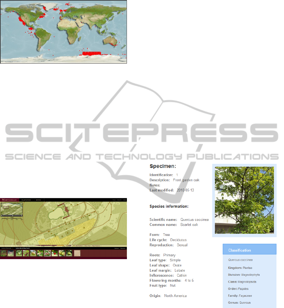
Figure 1: Distribution map generated by the OBIS system.
The systems that support the information for nat-
ural sites, on the other hand, are usually less com-
plex in their services, and tend to give simple descrip-
tions of the site with the intention of inviting visitors.
Still, some of these systems present some spatial in-
formation, in the form of dynamic maps of the space,
giving visitors a preview of the site. Graphical pre-
sentation of the information is more important here,
and no great detail on the collection’s specimens is
required. An example with a remarkable graphical
interface for a virtual visit is the Monticello Explorer
website (Thomas Jefferson Foundation, 2010) shown
in Figure 2; the user can navigate the interactive map
and see an interesting description of the highlights in
each area.
Figure 2: Monticello Explorer’s interactive map.
3 AN INFORMATION SYSTEM
FOR NATURAL SITES
The developed information system offers innovative
features for managing and publishing information
about a botanical site. The main characteristic of this
system is the implementation of a data model capable
of combining the internal information of the site, the
visitor-oriented information, and the scientific infor-
mation in a coherent manner. The approach is based
on current technologies, namely geo-referencing and
physical identification.
The Darwin Core biodiversity standard (Dar-
win Core Task Group, 2009) is used for exporting
datasets, contributing them to the scientific commu-
nity and making it easy to share information with
other organizations.
The proposed information system is designed for
small and medium-sized natural sites, allowing them
to manage their information in an effective way. It in-
cludes a spatial database and a web application which
presents information on botanical specimens.
3.1 Specimen and Species Information
A major goal in this work is to supply useful descrip-
tive information to visitors and site workers. They
can view information pages, used to display the data
related to the specimens. These pages can be accessed
from the various services of the system. An individual
page focuses on a specific specimen or set of speci-
mens, and includes its description, photographs, gen-
eral information about the corresponding species and
its taxonomic classification. Figure 3 gives an exam-
ple of one of these pages, where species information
uses the scientific descriptors in Latin.
Figure 3: Information page for an oak tree.
3.2 Spatial Services
This work explored the geo-referencing of the site
specimens, allowing the user to find the physical posi-
tion of any specimen. This information can be easily
inserted and corrected by the site staff, and some fea-
tures were developed based on this information.
The main spatial feature is the virtual tour map,
where the user can view a dynamic map of the site,
BIODIVERSITY INFORMATION SYSTEMS USING GEOREFERENCING AND PHYSICAL IDENTIFICATION
257
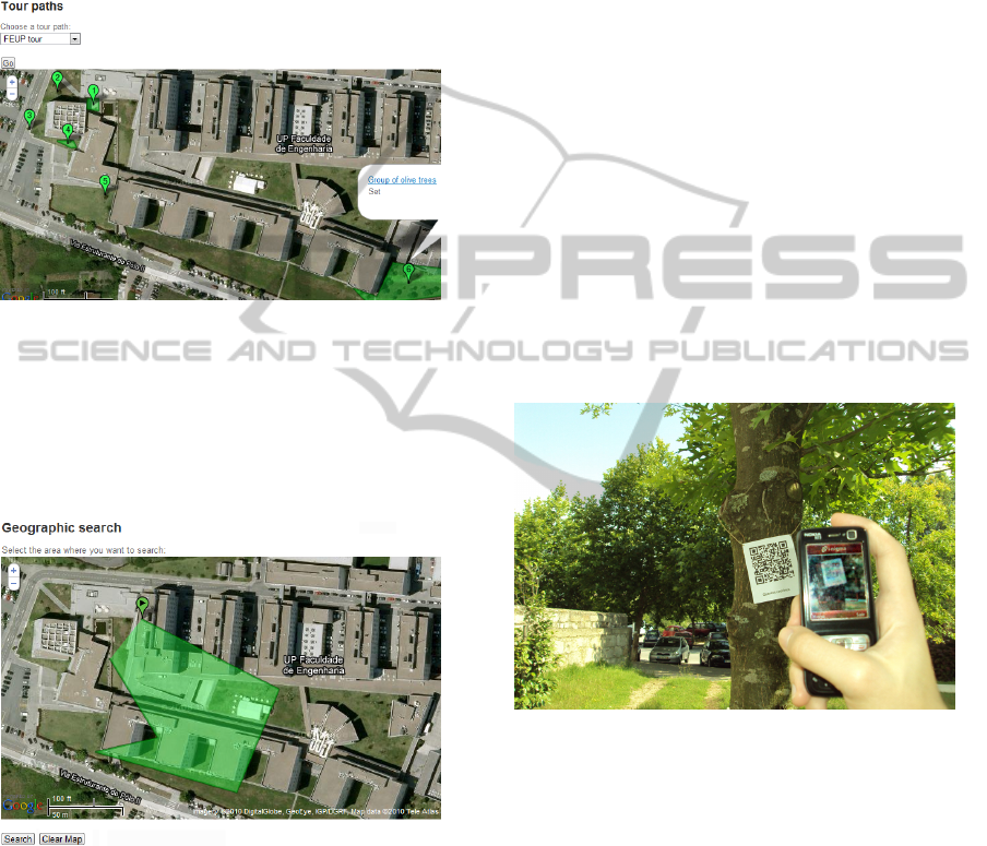
with specimens represented by markers and specimen
sets by polygons. Clicking in these markers the user
will have basic information in popup windows or go
to the full information page of the specimen. This
feature also includes the suggestion of tour paths (see
Figure 4), formed by sequences of interesting points
chosen by the site staff.
Figure 4: A suggested tour path.
A more demanding use of the spatial database ca-
pabilities is the geographic search feature. Here the
user selects a polygon in the map, which results in
a spatial query that returns the elements contained or
intersected by that polygon (see Figure 5).
Figure 5: Geographic search.
These features are the more obvious examples of
the potential of spatial data for natural sites. Other
services might be developed, depending on the scope
and needs of an individual site.
3.3 Physical Identification and Mobile
Services
Physical identification allows a user to see a speci-
men and access its information (and even update it)
on site. The QR code (Denso Wave, 2010), a two-
dimensional barcode standard, was chosen for this
purpose because it can be read by most mobile de-
vices with standard software. Any user with a com-
mon cell phone equipped with a camera and basic In-
ternet access can use this service.
For visitors, the local tour assistant feature is sup-
ported by this technology. The user identifies the
specimen with his mobile phone (see Figure 6), and
the device connects to the corresponding information
page in the Web application. This supplies casual vis-
itors and researchers with relevant information during
their visit to the site, instead of having to search for
it later. For the site staff, there are other uses for this
technology. They can edit the specimen’s information
when they are working, register operations they did
or upload photos of the specimen, all from their mo-
bile phones and using the identification codes. This
ability to easily identify a specimen and access its re-
lated contents creates a richer interaction with the sys-
tem, making it more useful. The code tags are gener-
ated automatically, using an external API, ready to be
printed (Google, 2010b).
Figure 6: Identification using a QR code.
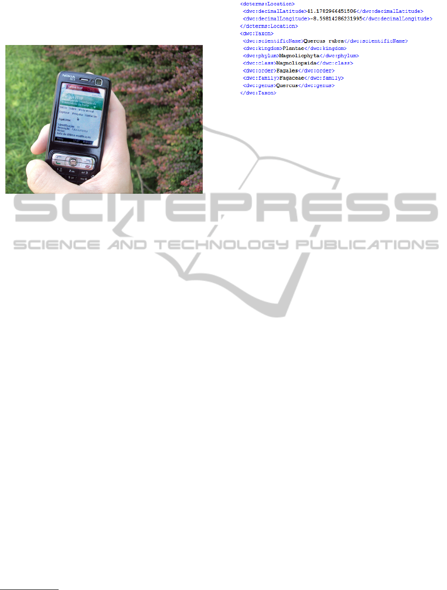
To offer these features, the Web application must
be suited for mobile devices. There are several op-
tions to solve this problem (Ekris and Vugt, 2010;
Mehta, 2008; Harris, 2008). In this case, as all the
services are intended to work in the mobile version
as well, a separate stylesheet was created to format
the pages according to the specification of mobile de-
vice screens. The system detects the kind of device
being used, either by the browser properties or the
screen size and selects the correct stylesheet. This
directs the user to the services in his mobile browser
(see Figure 7). The support of the different features
depends on the specifications of each device; while
the basic features like information pages can be used
even in low-end mobile phones, the more resource-
consuming features like the dynamic map will re-
WEBIST 2011 - 7th International Conference on Web Information Systems and Technologies
258
quire more powerful devices to work correctly (cur-
rent smartphones should be able to use all the features
in the mobile version).
Figure 7: Mobile version of the Web application.
Mobile technologies are constantly evolving and
its use will predictably continue to grow in the near
future (Kendrick, 2010). The combination of mo-
bile technologies with QR codes makes information
in large open spaces easily available to visitors.
3.4 Scientific Information
While the above features are sufficient for casual vis-
itors, researchers have a need for more formal and
organized information. The support for the Darwin
Core biodiversity standard allows the site to export its
datasets in a format that can be read by other orga-
nizations, thus making it possible to contribute to the
ongoing efforts on botanical repositories. Researchers
can download the site’s data in the specified format,
either for research or for integration in larger reposi-
tories.
When the user requests the data for a selected
specimen, the system provides an XML file with the
relevant terms of the Darwin Core description
3
. This
includes specimen identification, details on its geo-
graphic location, the scientific name of the species
and its taxonomic classification (see Figure 8).
3.5 Search and Additional Features
To fulfill the needs of the system, some additional
features were implemented, including various search
options. Apart from the above mentioned geo-
graphic search, the user can search by names (speci-
men description, common and scientific names of the
3
Darwin Core XML Guide, http://rs.tdwg.org/dwc/
terms/guides/xml/index.htm.
Figure 8: Excerpt from the Darwin Core description of a
specimen.
species), and attributes (the user selects one or more
characteristics from the available options, and the sys-
tem retrieves the specimens that verify them). Basic
user-related features were also implemented, includ-
ing authentication, access control, and user manage-
ment, to achieve a complete application that can be
put to real use.
4 ARCHITECTURE
The system is implemented as a web application de-
veloped in the PHP language and using the Zend
Framework. Zend is a flexible framework that fea-
tures the Model-View-Controller design pattern and
an extensive library of classes. Its use leads to the
creation of a solution with good portability, meaning
that it can be easily adapted to any natural site, requir-
ing only a suitable web server and little configuration.
From the available choices, the Zend Framework was
selected for its flexibility of use and good documenta-
tion (Lapsha, 2008).
The data model for natural sites comes from the
work of Jo
˜
ao Silva (Silva, 2009), and was refined to
better suit the current needs. As shown on Figure 9,
it can be divided into 4 main parts: the Park pack-
age includes classes related to the site and its users,
the Identification package focuses in the data about
specimens, the Taxonomy package deals with classi-
fication and species information, and the Geography
package holds the spatial data.
The spatial database is based on this model. The
PostgreSQL/PostGIS technology is used for support-
ing the geographical information. PostgreSQL is an
open-source database system renowned for its relia-
bility, stability and scalability. PostGIS (Obe and Hsu,
2010; PostGIS, 2010), its spatial extension, is a solu-
tion for storing and managing geographic data certi-
fied by the Open Geospatial Consortium (OGC).
Geographical information visualization, using a
JavaScript-based dynamic map, uses the Google
Maps service (Google, 2010a). Its combination with
BIODIVERSITY INFORMATION SYSTEMS USING GEOREFERENCING AND PHYSICAL IDENTIFICATION
259
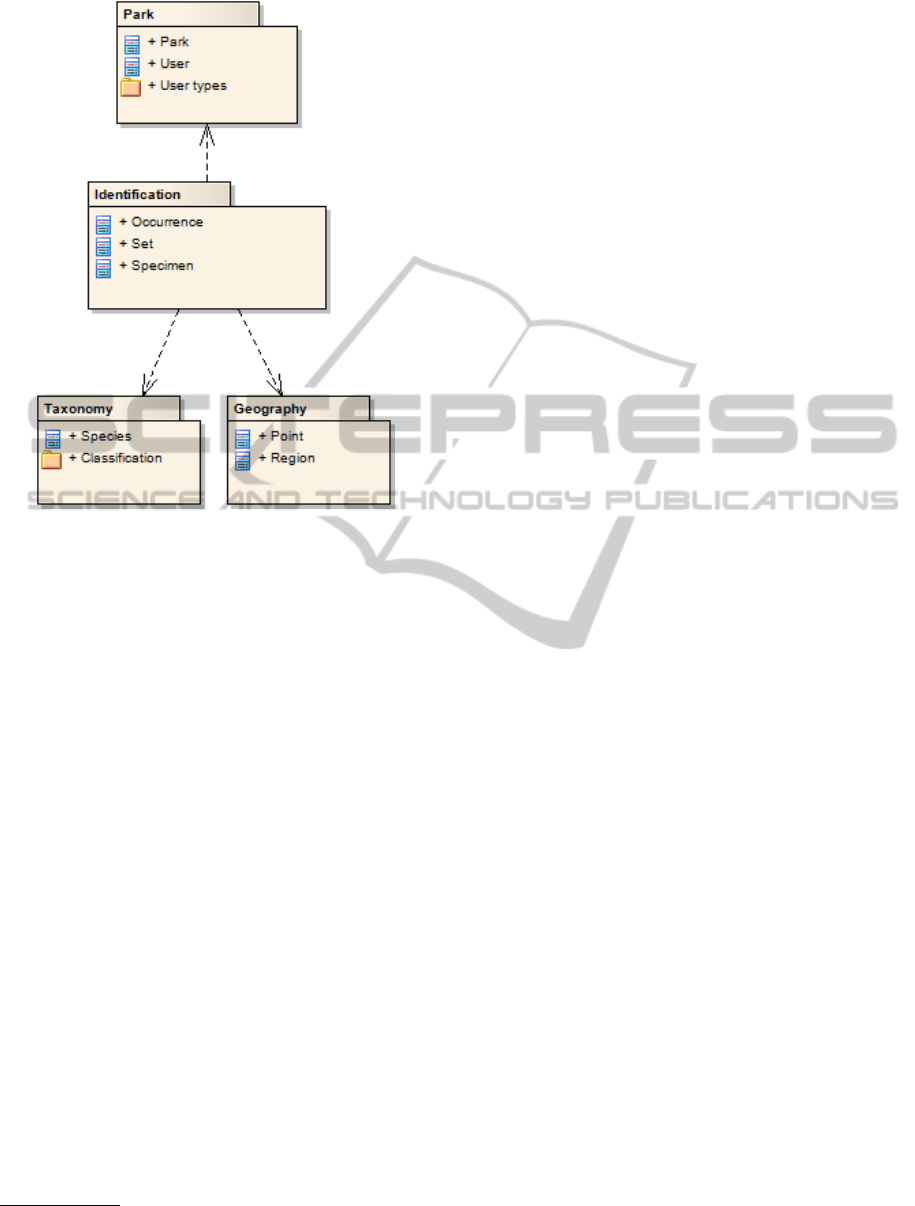
Figure 9: Package diagram of the data model structure.
the spatial database provides geo-referencing, mak-
ing it possible to insert and visualize the specimen’s
physical location in an intuitive way, and allowing
for other operations like the spatial search feature.
The required spatial calculations are accomplished by
PostGIS functions (BostonGIS, 2010), making use of
the capabilities of the database; the results are re-
turned as text coordinates to be used for visualization
in the dynamic map.
As an identification method, the system uses the
previously mentioned QR code. There are various
alternatives for specimen identification. RFID tags
(Smith and Konsynski, 2003; Want et al., 1999) can
be an effective solution, but require costly equipment
and would be usable only by the park maintainers.
The barcode system, on the other hand, is inexpensive
and readable on most mobile phones
4
, extending the
service to the visitors of the natural site. The QR code
standard was compared to other barcode types and
chosen for its efficiency and for being supported in
the majority of mobile devices (Kato and Tan, 2005;
Susono and Shimomura, 2006).
4
QR-Code Readers, http://www.mobile-barcodes.com/
qr-code-software/.
5 DATA COLLECTION
A practical aspect which has required some con-
cern was how to populate the database with accurate
species information. Users should not be forced to
create information such as species taxonomies, which
are well established in the scientific community, or
even generic descriptors such as specimen size or
shape, which are typically already described else-
where. We have collected general data on taxonomy
and species descriptions that can be applied to any
natural site. A case study was used to test the system
on a real garden.
5.1 Species and Taxonomic Information
After contacting various organizations, the Illinois
Plant Information Network (Iverson et al., 1999) al-
lowed the use of their data, which included common
and scientific names and various descriptive botani-
cal information on plant species. The data was dis-
tributed on thousands of text files with organized for-
matting but somewhat variable content. A small Java
application was developed to extract the information
and prepare it for insertion in the database. Data was
obtained for more than 3000 natural species.
The taxonomic information for the Plantae king-
dom was imported from a previous work (Silva,
2009). With this data, the system shows the taxo-
nomic classification for each species in the site.
All this information is associated with the plant
species, and can be used for any natural site, indepen-
dently from its specimens. While not all the species
have a description, many are covered by the collected
data, and others can be completed manually.
5.2 Case Study
The system was applied to one of the university gar-
dens, which is in the process of expanding its speci-
men collection. The garden has several species and is
large enough to take advantage of the developed ser-
vices.
This deployment of the system allowed us to test
its features in a real situation. For that purpose data
was collected on various specimens of the garden, in-
cluding descriptions and photographs, which were as-
sociated to the corresponding species. Some of the
species were not in the system yet and were inserted
with data from various sources (Fernandes and Car-
valho, 2003). The geographical coordinates were col-
lected for each specimen, using a GPS device. As the
device presented significant precision errors, part of
WEBIST 2011 - 7th International Conference on Web Information Systems and Technologies
260

the data was corrected using the application’s dy-
namic map. The collected spatial data was tested in
the virtual tour service, visiting the specimens for the
frontal area of the garden (as shown on Figure 10).
Identification codes were also printed for some of the
specimens allowing us to test the local tour assistant
and related mobile Web contents.
Figure 10: Virtual tour of FEUP’s gardens.
6 EVALUATION
The goal of this work was not only the creation of a
solution, but also an evaluation of the applicability of
the selected technologies in this domain.
Physical identification proved to be an effective
service when associated with mobile device contents.
The QR codes in particular can be easily generated
and printed, and the tests suggest that most common
mobile phones can use them. With the evolution of
mobile Internet and devices, this service is expected
to become even more practical in the future.
The geo-referencing of specimens is a useful fea-
ture both for visitors and for site workers, and spatial
data can also be important for research purposes. The
value of this data increases for larger spaces, where
the difficulty of locating a specimen is much more sig-
nificant.
Exporting data in Darwin Core format is relevant
for specialized users and can be valuable for research
purposes. The usefulness of the data will depend on
its content, the amount of information collected, and
the interest of the species in the collection. Neverthe-
less, the system allows for easy sharing of the data in
a standardized format supported by large global orga-
nizations.
The success of any system is, of course, dependent
on the reaction of its users; therefore, a more detailed
evaluation with different user groups would be useful
to better assess its practical value. A group of users in
the fields of Biology and Botany would be specially
relevant, to test the developed features and identify
possible points for improvement. The virtual tour and
the local tour assistant features should be tested with
visitors.
7 CONCLUSIONS
Biodiversity information systems are evolving in the
direction of spatial information. The Darwin Core
standard is also becoming more common in the shar-
ing of scientific data. Information systems for natural
sites are starting to use new technologies and there are
still vast opportunities for improvement.
The work explores two technologies for natural
sites. Physical identification of specimens supplies
visitors with relevant content in an easy way and
improves the efficiency of information management
tasks for the staff. Geo-referencing allows the collec-
tion and storage of precise information on the local-
ization of the specimens, which can then be visualized
by the users. The support of the Darwin Core standard
enables the site to share datasets with the scientific
community.
This work has resulted in a Web information
system focused on improving specimen information
management and offering distinct services for visi-
tors, with the support of current technologies. The
system is flexible and can be applied to botanical gar-
dens and other natural sites. Hopefully the result will
have an impact on biodiversity information systems.
These technologies can improve the services of nat-
ural sites and their use in this context can be further
explored.
The broad scope of the study also creates opportu-
nities for continuation, expanding the work for differ-
ent uses and related areas. One possibility is to con-
nect the application to a biodiversity repository (some
of which already provide APIs for data retrieval),
to get relevant information on species or taxonomy
whenever necessary. The application might also up-
load its data periodically to the repository, making it
available for research. Another possibility is to ex-
pand the system to the animal kingdom, for example
in a small zoo, with some modifications on the iden-
tification and geo-referencing methods. The spatial
capabilities of the database can be further explored as
well; global maps may show the origin of the collec-
tion’s species, or the retrieval place of the specimens.
Additionally, the increasingly common GPS capabil-
ities of mobile phones can be used in a location-
oriented tour assistant that will point interesting el-
ements near the user’s position, or help the staff to
BIODIVERSITY INFORMATION SYSTEMS USING GEOREFERENCING AND PHYSICAL IDENTIFICATION
261

geo-reference a specimen using the coordinates of the
device.
REFERENCES
BostonGIS (2010). Part 1: Getting
started with PostGIS. Available at
http://www.bostongis.com/?content name=postgis tut
01, last accessed September 2010.
Chavan, V., Rane, N., Watve, A., and Ruggiero, M. (2005).
Resolving taxonomic discrepancies: role of electronic
catalogues of known organisms. Biodiversity Infor-
matics, 2:70–78.
Darwin Core Task Group (2009). Darwin Core. Available
at http://rs.tdwg.org/dwc/index.htm, last accessed July
2010.
Denso Wave (2010). QRcode.com. Available at
http://www.denso-wave.com/qrcode/index-e.html,
last accessed July 2010.
Ekris, J. and Vugt, R. (2010). Optimizing a website for
mobile devices — modern nomads. Available at
http://modernnomads.info/wiki/index.php?page=
Optimizing%20a%20website%20for%20mobile%20
devices, last accessed July 2010.
Fernandes, M. F. and Carvalho, L. M. (2003). Portugal
Bot
ˆ
anico de A a Z — Plantas Portuguesas e Ex
´
oticas.
Lidel, 3 edition.
GBIF (2006). GBIF strategic and opera-
tional plans 2007-2011. Available at
http:/www.gbif.org/strategic plans.pdf, last accessed
September 2010.
Google (2010a). The Google Maps JavaScript API. Avail-
able at http://code.google.com/apis/maps/
documentation/javascript/, last accessed July 2010.
Google (2010b). QR-codes — Google chart tools. Available
at http://code.google.com/apis/chart/docs/gallery/qr
codes.html, last accessed July 2010.
Harris, S. (2008). Mobilising a web-
site, part 2: Strategies. Available at
http://pointbeing.net/weblog/2008/07/mobilising-
a-website-part-2-strategies.html, last accessed
September 2010.
IPNI (2010). The international plant names index. Available
at http://www.ipni.org/, last accessed September 2010.
ITIS (2010). Integrated taxonomic information sys-
tem. Available at http://www.itis.gov/, last accessed
September 2010.
Iverson, L., Ketzner, D., and Karnes, J. (1999). Illi-
nois plant information network. Available at
http://www.fs.fed.us/ne/delaware/ilpin/ilpin.html, last
accessed September 2010.
Kato, H. and Tan, K. T. (2005). 2D barcodes for mobile
phones. In Proceedings of the 2nd International Con-
ference on Mobile Technology, Applications and Sys-
tems (Mobility 2005), Nov. 15-17, 2005, Guangzhou,
China.
Kendrick, J. (2010). The (R)evolution of mobile.
Available at http://jkontherun.com/2010/04/01/the-
revolution-of-mobile/, last accessed September 2010.
Lapsha, S. (2008). Zend framework vs.
CakePHP, symfony, seagull, WACT, prado,
TRAX, eZ and CodeIgniter. Available at
http://sevalapsha.wordpress.com/2007/11/13/, last
accessed July 2010.
Mehta, N. (2008). Chapter 4 — adapting to user devices. In
Mobile Web Development, pages 20–28. Packt Pub-
lishing.
Neale, S. H., Pullan, M. R., and Watson, M. F. (2007). On-
line biodiversity resources — principles for usability.
Biodiversity Informatics, 4(0).
Obe, R. O. and Hsu, L. S. (2010). PostGIS in Action. Man-
ning Publications Co.
OBIS (2010). Ocean biogeographic informa-
tion system—about the data. Available at
http://www.iobis.org/tech/, last accessed July 2010.
PostGIS (2010). PostGIS: Documentation. Available at
http://postgis.refractions.net/documentation/, last ac-
cessed July 2010.
Silva, J. (2009). Sharing botanical information using
geospatial databases. Master’s thesis, Faculdade de
Engenharia da Universidade do Porto.
Smith, H. and Konsynski, B. (2003). Developments in prac-
tice X: Radio frequency identification (RFID) – an in-
ternet for physical objects. Communications of the
AIS, 12(19):301–310.
Smithsonian Institution (2010). Index nominum generico-
rum (ING). Available at http://botany.si.edu/ing/, last
accessed September 2010.
Susono, H. and Shimomura, T. (2006). Using mobile
phones and QR codes for formative class assessment.
Proceeding of Current Developments, pages 1006–
1009.
Thomas Jefferson Foundation (2010). Monticello explorer.
Available at http://explorer.monticello.org/, last ac-
cessed July 2010.
Want, R., Fishkin, K. P., Gujar, A., and Harrison, B. L.
(1999). Bridging physical and virtual worlds with
electronic tags. In Proceedings of the SIGCHI con-
ference on Human factors in computing systems: the
CHI is the limit, pages 370–377.
Wikispecies (2010). Wikispecies, free species directory.
Available at http://species.wikimedia.org/wiki/Main
Page, last accessed September 2010.
WEBIST 2011 - 7th International Conference on Web Information Systems and Technologies
262
