
EMPLOYING SOFTWARE MULTI-AGENTS FOR SIMULATING
RADIOLOGICAL ACCIDENTS
Tadeu Augusto de Almeida Silva and Oscar Luiz Monteiro de Farias
Universidade do Estado do Rio de Janeiro & Instituto de Radioproteção e Dosimetria (IRD)
Programa de Pós-Graduação em Engenharia de Computação
Rua S.Francisco Xavier, 524, sala 5017, CEP 20550-900, Maracanã, Rio de Janeiro, RJ, Brasil
Keywords: Agents, Radiological Accident, GIS.
Abstract: Through agent based systems we can build scenarios of radiological accidents that enable us to evaluate the
consequences of accidental contaminations. The incidental release of radionuclides in an environment might
cause the contamination of areas and people. So, it is necessary to make use of tools that allow us to foretell
the effects of the exposition of the population and to evaluate the consequences and to suggest measures of
protection. In this paper we introduce the use of software multi-agents systems immersed in a geographical
representation of the world, as a viable option to simulate radiological accidents and assess doses.
1 INTRODUCTION
Radiological accidents can result in significant
radiation exposures of workers and of the public.
These accidents usually occur as a consequence
of human activities in military, industry, medicine,
agriculture and research, involving the use of
radiation and radioactive substances that cause
radiation exposure in addition to the natural
exposure. Study the impact of radiological accident
in society and learn the lessons for the future it is a
way to prevent further accidents.
So, planning immediate answers and actions to
emergency situations is a critical factor to establish
security policies. Simulation models incorporating
software agents are one of the tools that can be
successfully employed in these tasks. They can
mimic the “real world”, and the interaction among
people, materials and radioactive sources. Through
computational simulation of agent-based models,
people can perceive, with details, the effect of
radioactive contamination in case of accidents, what
makes easy the understanding of the risks involved
and the damages caused in such situations.
In this article we’ll show how to create an
environment where software agents simulate
radiological accidents. Our agents will have some
properties, as: mobility, reactivity and objectivity.
People and radioactive sources and elements will be
also represented by software agents, In this way,
through agent-based simulation, we intend to study,
analyse and manage these complex systems
(radiological accidents).
Here we use the following definition, of agent
(Franklin, Graesser, 1997): “A system situated within a
given environment, that senses that environment
through its perception mechanism and acts on that
environment and/or on other agents, as time flows,
in pursuit of its own agenda, plans or beliefs.
Eventually the agent´s perception/action mechanism
evolves with time”.
In this study it is necessary that multi-agent
systems can provide a computational platform where
the dynamic of spatio-temporal systems can be
analysed and the agents can interact ones with others
through communication mechanisms (Wooldridge,
2002) .
2 RADIOLOGICAL ACCIDENTS
Radiological accidents are accidents that occur in
nuclear or radioactive installations and are
characterized by the existence of intense fields of
not intentional radiation, not controlled release in the
environment of amounts of radioactive material, and
involve exposition or contamination of human
beings or the environment, being able to cause
serious damages or death.
436
Augusto de Almeida Silva T. and Luiz Monteiro de Farias O. (2007).
EMPLOYING SOFTWARE MULTI-AGENTS FOR SIMULATING RADIOLOGICAL ACCIDENTS.
In Proceedings of the Ninth International Conference on Enterprise Information Systems - AIDSS, pages 436-439
DOI: 10.5220/0002385904360439
Copyright
c
SciTePress

The incidental release of radionuclides in the
environment might cause the contamination of areas
and people. So, it is necessary to make use of tools
that allow us to foretell the effects of the exposition
of the population and to evaluate the consequences
and to suggest measures of protection (IAEA, 1996).
First of all, we need to identify the amount of
contaminated people, degree or dose of radiation
received and a more elaborate map (georeferenced
information) from the areas impacted (Agape, 2005).
A radiological accident can affect the public
transportation system, generate zones of exclusion
in the contaminated areas, leading to the
displacement of people, damage the water supply,
and overcrowd hospital services, causing serious
social problems (Agape, 2005).
For the evaluation of the dose received for
individuals it is necessary to take in consideration
the release rate of the radioactive source, its exact
distance from the exposed individuals, the existence
of materials (shield) between the radioactive source
and the exposed individuals, and the time of
exposition of the individuals. Through the
following formulas we can determine the dose:
A=A
0
e
λ.t
(1)
Where: A is the activity of a radioactive source, A
0
,
is the activity at time t=0, and λ
is the constant of
disintegration, meaning the rate in which
disintegration proceeds.
X = Γ.A / d
2
(2)
Where,
X = exposition rate, in R/h ( Roentgen / hour)
A = source activity, in Ci ( Curie )
d = distance between the source and the point of
measure, in meters.
Γ
= a characteristic constant of each radioactive
source, also known as factor gamma, in (R.m
2
) /
(h.Ci)
over which
D = X.t
(3)
Where,
D = absorbed dose, in Gray (Gy)
X = exposition rate, in R/h
t = time, in hours (h)
DE = D.FQ
(4)
Where,
DE = dose equivalent , in Sievert (Sv)
D = absorbed dose, in Gray (Gy)
FQ = quality factor of radiation, for gamma
radiation FQ equals 1
3 ARCHITECTURE OF
AGENT-BASED SYSTEMS TO
SIMULATE RADIOLOGICAL
ACCIDENTS
The goal of our agent-based system is to furnish
useful information related to a given radiological
accident. This class of information is usually related
to: i) the quantity of persons that were esposed; ii)
the effective dose they received; iii) determination,
localization and extension of contaminated areas.
Not always it is possible to determine who
where the persons exposed, neither their exact
number. This would be the case, for example, of a
terrorist attack with a radioactive source in the
public system of transportation, for example in a
train or in a subway. Notwithstanding it is very
important for the public health system, to have a
estimate of the people involved and of the effective
dose they received, in order to calculate the medical
resources that will be need to face the problem, to
warn the population against the risks of exposure,
and also to manage the entire situation, all the risks
involved, descontamination procedures, etc.
Our model is based on the formula of radioactive
dispersion in the air (equation 2), leading in account
the radionuclide and its activity, the distance of the
people exposed to the radioactive element, the time
of exposition, as well as possible shields. We also
consider eventual movements of persons and of
radioactive sources. Both of them are represented by
very simple agents, People agents suffer the effects
of radioactive source agents, based on equation 2,
and these effects are registered on the state variables
of people agents. Shield effects could, as well, be
incorporated into the model.
The source agent has the following state
variables: i) The source Id; ii) Its position, given by
a tuple of coordinates (x, y, z); iii) Its activity A;
iv) The factor Γ for the specific source; v) The
quality factor (FQ), a factor used to weight the
absorbed dose with regard to its presumed biological
effectiveness. A typical agent, representative of a
person, has the following state variables: i) Person
Id; ii) Its position, given by a tuple of coordinates (x,
y, z); iii) Time of exposition; iv) Shield effect; v)
The absorbed dose; vi) The effective dose.
In our model we need also a representation for
the space, the environment from where our agents
take sensory inputs and produce as output actions,
that is, their movements. Normally Geographical
Information Systems (GIS) use raster or vector
structures to represent space in bi-dimensional
EMPLOYING SOFTWARE MULTI-AGENTS FOR SIMULATING RADIOLOGICAL ACCIDENTS
437
models. In some cases a third dimension is
represented through digital elevation models (dem)
of a terrain. Given a GIS spatial representation (a
shape file, for example), we’ll add to it software
agents and the structure of a dynamic spatial model,
in order to simulate the dynamic of radiological
accidents. The GIS spatial representation is the
environment or locus, where agents of our Agent-
Based Models will operate.
For each specific phenomenon, we are interested,
only, in particular information about the
environment. So, considering the geographical space
where the phenomenon develops, we need to filter
only the aspects of the environment we are
interested in, that is, the features that will compose
the environment as seen by the agents, and where all
the process will be simulated. This is not a difficult
task, for data is organized on GIS in different layers,
such that: utilities, river and lakes, roads and rails,
soil maps, land parcels, etc. We need to select only
the layers we are interested in. Objects that are not
of interest must be discharged, for an environment
full of superfluous objects would unnecessary
complicate the implementation and reduce the
simulation performance. So, depending on the
problem, we can simplify considerably the
simulation, as we´ll see below in our case study
(
Farias, Leite, 2005).
4 CASE STUDY: THE
RADIOLOGICAL ACCIDENT
AT COCHABAMBA, BOLÍVIA
We will take as our case study the radiological
accident occurred in Cochabamba, Bolivia, in 2002.
This accident was minutely documented and
physicaly reconstructed by the IAEA (IAEA, 2004),
and the assessment of doses estimated. So, we have
a valuable data to compare with the results of our
agent-based simulation and to validate our model.
In April 2002 an accident involving an industrial
radiography source containing
192
Ir occurred in
Cochabamba, Bolivia, some 400 km from the
capital, La Paz. The source, in a remote exposure
container, remained exposed within a guide tube,
although this was not known at the time. The
container, the guide tube and other equipment were
returned from Cochabamba to the headquarters of
the company concerned in La Paz as cargo on a
passenger bus. This bus carried a full load of
passengers for the journey of about eight hours from
Cochabamba to La Paz. The equipment was
subsequently collected by company employees and
transferred by taxi to their shielded facility. Routine
radiation measurements made there established that
the source was still exposed and actions were then
taken to return the source to its shielded container
(IAEA, 2004).
In our case study, due to the source
characteristics, the effect of the radiation was
relevant only to people situated a few meters from
the source, that is, for people inside the bus. If we
look at the exposition rate, absorbed dose and dose
equivalent (effective dose) formulas, we’ll see that
all these measures - given a specific source - are
dependent only of the relative position between the
source and the people exposed and of the time of
exposition. So, in this very special case, it doesn’t
matter the path followed by the source in its journey
from Cochabamba to La Paz. Assuming that all
passengers, after entering the bus, didn’t change
their seats, what is relevant to assess doses is: i) the
distance between each passenger and the radioactive
source that remained fix during the entire journey;
ii) the exposure time.
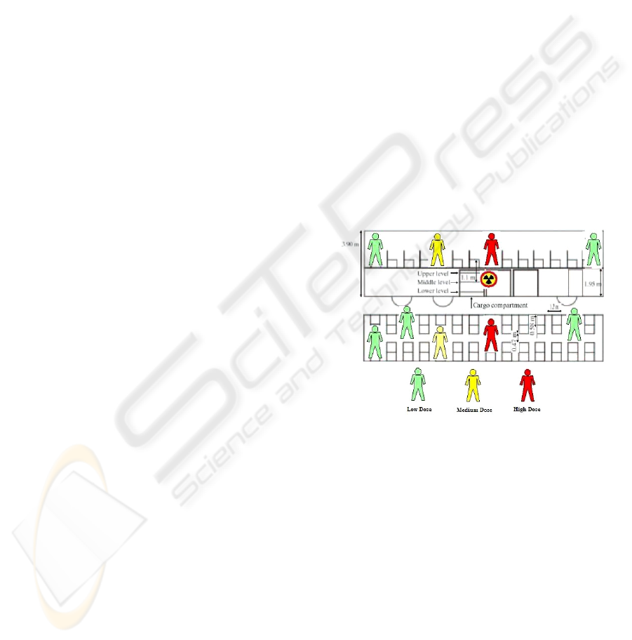
Figure 1: Bus passenger.
Figure 1. shows the relative distance between the
passengers and the source, as well a classification of
doses received.
“The time frame of the exposures of the bus
passengers is reasonably well defined. For most of
the passengers on the bus that day, this is an eight-
hour period from 16:00 to 24:00. There are some
variations on this; for example, the duration would
have been 30 minutes shorter for those passengers
picked up at Quilacollo and it would have been
longer for those passengers from Cochabamba who
spend some time on the bus before it departed. Also
some time would have been spent off the bus during
a meal stop
” (IAEA, 2004).
In our Agent-Based simulation we employed
essentially the same formula (equation 2) for doses
ICEIS 2007 - International Conference on Enterprise Information Systems
438
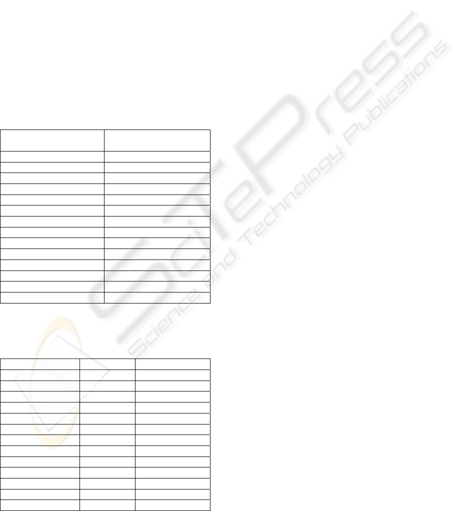
estimation. However, we summed 14 cm to the seat
heights, for the whole body dose may be better
represented at an eight of about one third of the way
up the torso (see table 1).
The received dose (d) for the passengers, after
reconstruction of the dose and technical analysis
conducted by an IAEA technical mission, was
calculated between a minimum 10mGy (~DE =
10mSv) to a 190 maximum mGy (~DE = 190 mSv)
for 8 hours of the bus trip (See table 2). The dose
received annually for the worldwide population due
to natural radiation is calculated in 1,12 mSv/year
and in the case of a source of
192
Ir, it is necessary
only 4 seconds of exposure to surpass the limit of
annual dose (1,12mSv/year).
As we can see from tables 1 and 2, the
simulation gave us upper limits for doses absorbed,
basically for not considering shield effects.
Table 1: Ranges of estimated doses (Gy) to the bus
passengers by Software Agent Simulation.
Seat number High Dose
(Agent simulation)
1–4 0.02
5–6 0.03
7–10 0.04
11–14 0.07
15–18 0.13
19–22 0.31
23–26 0.85
27–30 1.08
31–34 1.00
35–38 0.40
39–42 0.16
43–46 0.09
47–50 0.05
51–55 0.03
Table 2: Ranges of estimated doses (Gy) to the bus
passengers based on the dose reconstruction performed by
the IAEA team (IAEA, 2004).
Seat number Upper Lower
1–6 0.010 0.001
7-10 0.015 0.002
11-14 0.025 0.005
15-18 0.040 0.010
19-22 0.070 0.020
23-26 0.160 0.040
27-30 0.190 0.050
31-34 0.160 0.040
35-38 0.070 0.020
39-42 0.040 0.010
43-46 0.025 0.005
47-50 0.015 0.002
51-55 0.010 0.001
5 CONCLUSIONS
Trough this case study we could have a first idea of
the magnitude of the radiological accident and its
impact.
Simulating the number of people contaminated
by agent-based systems we can estimate the
absorbed doses, its spatial distribution and possible
physical consequences by the effect of the radiation.
The researcher can simulate a non-natural
radioactive dispersion, building an environment, in
a delimited area, where he can find parameters for
analysing and studying the phenomenon.
REFERENCES
Wooldridge, M. J., 2002. An Introduction to MultiAgent
Systems. John Wiley & Sons, Ltd, April.
Franklin, S. , Graesser A., 1997. Is it an agent, or just a
program?: a taxonomy for autonomous agents. In
Inteligents Agents III: Agent Theories, Architectures,
and Languages, edited by J. P. Muller, M. J.
Wooldridge, and N. R. Jennings, Berlin: Springer,
pp.21-35.
Farias, O. L. M, Leite, L. T, 2005. Simulation and
Control of Maritime Area through Multi-Agent
Systems and Geographical Information Systems . In:
International Conference on Intelligent Agents, Web
Technologies & Internet Commerce - IAWTIC 2005.
Vienna. Proceedings of the International Conference
on Intelligent Agents, Web Technologies and Internet
Commerce - IAWTIC'2005. Los Alamitos, California :
Edited by M. Mohammadian, v. 1. p. 734-738.
IAEA, 1996. Radiation Safety, Vienna, Austria.
Agape, A.M. , Arutyunyan, R.V., Yu.Kudrin, A., Eliseev,
A.M., 2005. Experience of past radiation accidents
and problems of response to possible dispersion of
radioactive material in urban conditions.
International Conference on the safety and security of
radioactive sources towards a global system for the
continuous control of sources throughout their life
cycle.
IAEA, 2004. The Radiological Accident in Cochabamba.
Vienna, Austria.
EMPLOYING SOFTWARE MULTI-AGENTS FOR SIMULATING RADIOLOGICAL ACCIDENTS
439
