
GEOSPATIAL SEMANTIC QUERY BASED ON CASE-BASED
REASONING SYSTEM
Kay Khaing Win
University of Computer Studies, Yangon,Myanmar
Keywords: Geospatial data, geospatial semantic, semantic query, spatial reasoning, geospatial semantic web.
Abstract: In today’s fast-growing information age, currently available methods for finding and using information on
the Web are often insufficient. Today’s retrieval methods are typically limited to keywords searches or sub-
string matches, therefore, users may often miss critical information when searching the web. After
reviewing the real world Semantic Web, additional research is needed on the Geospatial Semantic Web. We
are rich in geospatial data but poor in up-to-date geospatial information and knowledge that are ready to be
used by anyone who wants to use. In this paper, we implement a framework of geospatial semantic query
based on case based reasoning system that contributes to the development of geospatial semantic web. It is
important to establish a geospatial semantics that support for effective spatial reasoning for performing
geospatial semantic query. Compared to earlier keyword-based and information retrieval techniques that
rely on syntax, we use semantic approaches in our spatial queries.
1 INTRODUCTION
Today’s retrieval methods are offering no support
for deeper structures that might lie hidden in the
data: therefore, users may often miss critical
information when searching the Web. At the same
time, the structure of the posted data is flat, which
increases the difficulty of interpreting the data
consistently. There would exit a much higher
potential for exploiting the Web if tools were
available that better match human reasoning. In this
vein, the research community has begun an effort to
investigate foundations for the next stage of the
Web, called Semantic Web.
A rich domain that requires special attention
is the Geospatial Semantic Web. In the future, the
Geospatial Semantic Web will allow the returning of
both spatial and non-spatial resources to simple
queries, using a browser. However, in the same way
as with the Semantic Web, in order to approach the
Geospatial Semantic Web it is necessary to solve
several problems.
In this paper, we implement a framework of
geospatial semantic query based on case-based
reasoning system that contributes to the
development of geospatial semantic web. We intend
to develop a simple and powerful framework for
people to interpret the semantics of geospatial entity
classes. The remainder of this paper is organized as
follows. Section 2 describes about the geospatial
semantic web and geospatial semantic. Section 3
describes the role of semantic knowledge in case
searches. We describe measuring semantic similarity
in section 4. Section 5 describes case-based
reasoning system. We describe conceptual
framework of geospatial semantic query in section 6.
Finally, we describe conclusion in section 7.
2 GEOSPATIAL SEMANTIC WEB
AND GEOSPATIAL SEMANTIC
Geospatial Semantic Web is a natural extension of
the current geospatial systems and applications that
enable users to query more precisely the data they
need. To accomplish the Geospatial Semantic Web,
two research issues are apparent: 1
st
is geospatial
data query and 2
nd
is method to assess the semantics
of available data sources. The retrieval methods of
semantic web are developed by incorporating the
data’s semantics and search process. Such a
development needs the development of multiple
spatial and terminological ontologies. The needs of
all the above mentions enforce to the development
of Geospatial Semantic Web.
The Geospatial Semantic Web will be a
significant advancement in the meaningful use of
356
Khaing Win K. (2006).
GEOSPATIAL SEMANTIC QUERY BASED ON CASE-BASED REASONING SYSTEM.
In Proceedings of the Eighth International Conference on Enterprise Information Systems - AIDSS, pages 356-359
DOI: 10.5220/0002469203560359
Copyright
c
SciTePress

spatial information. With the flexible incorporation
of geospatial information retrieval; will become
precise to the level that the results of user queries
will be immediately useful, without weeding out
irrelevant hits. In order to address geospatial
semantic, one needs computational methods that go
beyond syntax comparisons. In the case of the
Geospatial Semantic Web, three types of geospatial
semantics are distinguished, each requiring different
computational methods (Egenhafer 2002):
• semantics of geospatial entity classes
• semantics of spatial predicates
• semantics of geospatial names
The classification of geographic entities is
geospatial, even when no geometry is involved.
Non-geometric concepts, such as building, road,
and place are geospatial concepts that are used for
describing the semantics of geospatial objects.
Semantic relations are a typical way to describe
knowledge about concepts. We refer to geospatial
entity classes by words or sets of synonym
interrelated by hyponymy and metonymy relations.
3 ROLE OF SEMANTIC
KNOWLEDGE IN CASE
SEARCHES
In order to understand and appreciate, the role and
importance of semantic knowledge and sentence
structure in case-retrieval process, we need to
understand the working of systems that do not use
this information and rely only on the word
knowledge. Based on the inputs given by the user, a
relevant case is retrieved and output to the user. A
set of questions are posed to the user, the answers to
which are compared to the ones listed out under the
relevant cases that are retrieved. A question answer
pair typically behaves as an attribute value pair. The
answers provided by the user to the questions posed
are compared to these values and a match is found.
In our method, similar concepts are playing
similar roles in the sentences. A sentence is
represented using an Interlingua called, Universal
Networking Language (UNL). Information in every
sentence is captured at three levels: the concepts that
are involved, the role they play in the sentence, and
attributes that describe their properties. Universal
Networking Language (UNL), proposed by United
Nations University, represents natural language in
the form the links among them see in figure 1. UNL
represents information sentence by sentence. This
hypergraph is also represented as a set of directed
binary relations, each between two concepts present
in the sentence. Concepts are represented as
character strings called Universal Words (UW).
The knowledge within a document is
represented in three dimensions: Universal Words
(UW): describe concepts that are present in a
document; UNL Relations: describe the relations
between the concepts involved in the sentence and
the roles (e.g. subject or object in case of nouns) that
they play in conveying the meaning of a sentence;
UW attributes: capture and represent properties of
concepts like tense of a verb.
4 MEASURING SENTENCE
SIMILARITY
Similarity between two sentences is measured on
two counts: how similar are the concepts involved in
the two sentences and how similar roles do the
concepts play in the sentence? Since relations
describe the roles that concepts play in the meaning
of the sentence, similar structure sentences will have
similar relations in their respective UNL
representations. Taking UNL representation, we
compare each of the concepts occurring in UNL
representation with the concepts that appear in the
UNL representation for the problem sentence. The
similarity score is computed using the method
proposed by (Resnik, 1999) where similarity of two
concepts is determined by the information that they
share indicated by the most specific concept that
subsumes them both in a concept hierarchy. Resnik
used WordNet for this hierarchy of concepts. For
every concept, its likelihood of occurring in the
document is calculated by counting the number of
instances of itself and the concepts subsumed by it in
the document. Therefore, the more general a
concept, the more number of occurrences it will
have. Probability (or likelihood) of occurrence of a
concept is given as
P(c) =Nc/N
where Nc is the number of times a concept C occurs
in the document and N is the total number of words
in the document. Using the Information Content
Theory, the Information Values associated with each
concept C is negative log of the likelihood of
occurrence of the concept.
IC(c) =-ln (P(c))
We too used WordNet to arrange concepts in
a hierarchy and assign them Information Content
Values in the manner proposed by (Resnik, 1999).
However, in Resnik's method, the sense of the
concepts being matched is not known.
GEOSPATIAL SEMANTIC QUERY BASED ON CASE-BASED REASONING SYSTEM
357
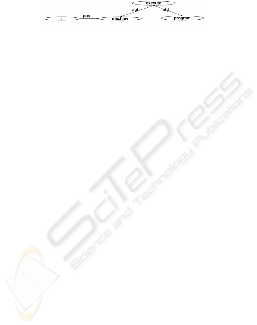
Figure 1: UNL graph for “My machine is executing programs”.
Therefore, a similarity score is measured for all
senses of the two concepts and the maximum among
them is chosen. We uses K-Nearest Neighbor (kNN)
algorithm to determine the similarity between cases.
Use of UNL Universal Words helps us restrict our
attention to only one sense of a concept and
therefore produces the most useful similarity score.
If there are N1 and N2 nodes (or words) in the two
sentences S1 and S2 respectively, then the concept
similarity measure is calculated as
(∑
n1
∈
s1
∑
n2
∈
s2
SimScore (n
1
, n
2
)) / (N
1
*N
2
)
The sum of all the similarity scores over all pairs of
concepts that are matched for two sentences is taken
and averaged over the number of comparisons made.
We use this concept similarity in our geospatial
semantic query system. In our proposed system
(CBR system), the case base reasoner use this
concept similarity measure to retrieve the most
similar case (or cases) comparing the case to the
library of past cases.
5 CASE BASED REASONING
SYSTEMS
CBR is a view of knowledge acquisition method for
problem-solving and interpretation, and a method for
machine learning. CBR is to solve a problem by
remembering a previous similar situation and by
reusing information and knowledge of that situation.
In Case-Based Reasoning (CBR) systems expertise
is embodied in a library of past cases, rather than
being encoded in classical rules. Each case typically
contains a description of the problem, plus a solution
and/or the outcome.
We implement a framework of geospatial
semantic query based on case based reasoning
system that contributes to the development of
geospatial semantic web. In the framework of
geospatial semantic query, spatial relations are
stored in case based library of case based reasoning
system. Spatial relationships between objects
provide details of the retrieve location of objects
e.g., “the train is to the right of the platform.” Such
relationships are especially needed to locate objects
in which case the location of such objects may be
approximate during the spatial relationships between
the objects it is near. It is impossible to determine
the spatial relationship between x and y when x
completely obscures y, as would be the case if x was
inside of y. Since this information is not always
determineable from object co-ordinates, without this
aspect, semantic query cannot be supported. Spatial
relationships may be represented explicitly via
relations. We intend this reasoning system to be
geospatial reasoning using the case based reasoning
methodology. Geospatial reasoning is widely used
by humans to understand, analyze, and draw
conclusions about the spatial environment.
6 CONCEPTUAL FRAMEWORK
OF GEOSPATIAL SEMANTIC
QUERY
To illustrate how the principles of the conceptual
framework of geospatial semantic query based on
case-based reasoning system. Our proposed
framework shown in figure 2 is intended to
implement on the geospatial semantic query system
that contributes to the development of geospatial
semantic web. The sole purpose of this task is to
make the system understand the terms appearing in
the user’s query input. The reasoning capability of
models of spatial relations is critical to complete the
task of geospatial semantic query. To keep pace with
future developments in geospatial reasoning, we
argue that the system should be designed with an
open architecture to allow for new models and
extensions of existing models to be incorporated into
the system easily.
Our proposed framework mainly consists of
case based reasoning system. Spatial relations are
stored in case based library of case based reasoning
system. Case based reasoner matches the current
problem on the query content with the cases in the
case based library, and similar cases are retrieved.
We examine the use of pairs of terms found in close
proximity to each other to be used as the query
terms. Additionally, we are conducting experiments
using a more refined problem-specific sense of
relevance: a case is considered relevant only if it is
actually cited in the actual opinion of the problem
case. The retrieved cases are used to suggest a
solution which is reused and tested for success.
ICEIS 2006 - ARTIFICIAL INTELLIGENCE AND DECISION SUPPORT SYSTEMS
358
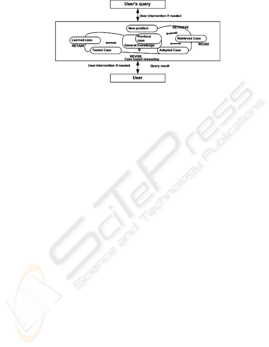
Figure 2: Conceptual framework of geospatial semantic query.
If necessary, the solution is then revised. Finally the
current problem and the final solution are retained as
part of a new case. The case based reasoner
produces the query result (final solution or outcome)
to the user.
7 CONCLUSIONS
This paper introduces the new concept of geospatial
relations on case-based reasoning and process a
solution to query of geospatial semantic. To handle
geospatial semantic query, we propose a conceptual
framework that takes advantage of case-based
reasoning system. The emphasis of this paper has
been reasoning on geospatial relations to handle
geospatial semantic queries. In our system, we
presented an approach for querying geospatial
semantic based on case-based reasoning system that
contributes to the development of Geospatial
Semantic Web. In our system, we use geospatial
relations to be efficient and effective reasoning
system. This paper describes efforts in developing
for conceptual framework of a geospatial semantic
query system.
REFERENCES
Allen J. F., 1983 “Maintaing knowledge about temporal
interval communications” in ACM, 26 (11): 832-843.
Andrea M. R. and Egenhofer M.J, 2004 “Comparing
Geospatial Entity Classes: An Asymmetric and
context-Dependent Similarity Measure”
International Journal of Geographical Information
Science 18 (3).
Bhattacharyya P.,Choudhury S.R.,Gupta S.S., 1998 "Man
power Planning with Case Based Reasoning: The
Selector", International Conference on Knowledge-
based Computer Systems (KBCS).
Chakraborti S.,Balaraman V.,Vattam S.S., 2000 "Using
CBR inexact search for intelligent data retrieval",
International Conference on Knowledge-based
Computer Systems (KBCS).
Egenhofer, M. 2002, “Toward the Semantic Geospatial
Web” ACM-GIS Mclean, VI (in press)
Jones C.B and Purves R. and Ruas A. 2001 “Spatial
Information Retrieval and Geospatial Information
Theory”, pages 322-335. Springer-verlag.
Jones C.B and Purves R. and Ruas A. and Sanderson M.
and Sester M and Van Kreveld M.J. and Weibel R.
2002 “Spatial Information Retrieval and
Geographical Ontologies: an overview of the SPIRIT
Project”. In Proceeding of the 25
th
Annual
International ACM SIGIR Conference, Pages
387_388
Jun-ichi A., Koioru H., Akira S., Yutaka Y. and Testsuji S.
2002 “Towards the Real World Semantic Web-Web
Search based on Spatial and Temporal Metadata”
vol.1.No.3 June 2002.
Mcauley K. 2001 “Geospatial Mapping and Navigation of
the Web.” In proceedings of Tenth International
World Wide Web Conference, page Session P7.ACM
Press.
Mclean, Virginia, 2002. “Toward the semantic geospatial
web” Proceedings of the 10th ACM international
symposium on Advances in geographic information
systems.
Ohlbach, H. J and Lorenz B. 2005 “Geospatial Reasoning:
Basic Concepts and Theory” 31 March 2005
REWERSE.
Resnik P., 1999 “Semantic similarity in a taxonomy: An
infomation-based measure and its application to
problems of ambiguity in natural language”, Journal
of Artificial Intelligence Research.
Sistal P., Yu C. ,and Haddack R. 1994 “Reasoning about
spatial relationships in picture retrieval systems”. In
Proc. Of the 20
th
Int’t Conf. on very large Data
Bases.
Sharma J. and Flewelling D. M. 1995 “Inferences from
combined knowledge about topology and directions.”
In Proc. Of 4
th
Int’t Symposium on large Spatial
Databases, Portland, Marine, USA
GEOSPATIAL SEMANTIC QUERY BASED ON CASE-BASED REASONING SYSTEM
359
