
The Effect of Transfer of Conservation Authority towards Marine
Protected Areas in Sumatra Utara Province-Indonesia
Hamzah Lubis
1
,
Mayang Sari Yeanny
2*
1
Environmental Lecturer at the Medan Institute of Technology, Chair of the S2 / S3 Alumni of Natural Resources and
Environmental Management at the Universitas Sumatera Utara
2
Department of Biology, Faculty of Mathematics and Natural Sciences, Universitas Sumatera Utara,
Keywords: Conservation, Marine Protected Areas, Limited Protection Areas, Sumatera Utara
Abstract: The study was carried out descriptively, data collection with questionnaire, followed by observation and in-
depth interviews with the head of Department of Marine and Fisheries, head of Environmental Services
Department, head of District/City and Province Department of Culture and Tourism and the head of MPA
which managed by the community in Sumatera Utara.The results of the study indicated that the Sumatera
Utara Provincial Government was not ready to accept the transfer of conservation management authority
from districts / cities in Sumatera Utara. MPA that has been determined were; (1) MPA Sawo-Lahewa in
Nias Utara District in 2017 and (2) Limited Protected Area of Toli Shad in LabuhanBatu from 2016 to 2018
have not been managed. Thus, the 3 MPAs in Tapanuli Tengah, Nias Selatan and SerdangBedagai which
were previously managed by the District Government have not been managed by the Sumatra Utara
Provincial Government and are still in the backup stage. The MPA proposal currently being carried out by
Madina District Government, Batubara District Gov. and Sibolga City Gov. as well as the proposal of Batak
Fish (Neolissochilussumatranus) Limited Protection Area, Dara Shellfish in Asahan District and Turtle and
Sea Cucumber in Asahan District had not been followed up by the Provincial Government. Similar to the
data collection, coaching and mentoring of private MPAs managed by the community had not been well
implemented by the Provincial Government.
1 INTRODUCTION
Law No. 32/2004 concerning Regional
Administration authorizes District / City
Governments to manage the sea as wide as 4 miles
from the coastline. Therefore, the District / City
Government managed the Regional Marine
Protected Areas (RMPA) and fostered conservation
areas managed by the community in the form of
Marine Protected Areas (MPA).With the issuance of
Law No. 23 of 2014 on Local Government, the
District / City Government did not have the
authority to manage the oceans, including
conservation management.
Article 27 of Law No.23 of 2014 describes the
transfer of authority from district / city to the
Provincial Government. Provincial authority to
manage natural resources in the sea at a maximum of
12 (twelve) nautical miles measured from the
coastline towards the high seas and / or towards
island waters. Such authorities include: (a).
exploration, exploitation, conservation, and
management of marine assets outside oil and gas;
(b). administrative arrangements; (c). spatial
arrangement; (d). participate in maintaining security
at sea; and (e). participate in maintaining state
sovereignty.
This research was conducted to obtain the effect
of the transfer of authority on the management of
MPA in Sumatera Utara, where before 2004 MPA
management was carried out by the District / City
Government and there was no MPA that was
managed by the Provincial Government. Therefore,
this paper discussed the problems that occur due to
the political policy.
Marine Protection Area (MPA) based on
Government Regulation Number 60 of 2007
concerning Conservation of Fish Resources, as a
protected water area, managed with a zoning system,
to realize sustainable management of fish resources
and the environment. The definition of fish refers to
Law No. 45 of 2009 concerning Fisheries, is all
158
Lubis, H. and Sari Yeanny, M.
The Effect of Transfer of Conservation Authority towards Marine Protected Areas in Sumatra Utara Province-Indonesia.
DOI: 10.5220/0009899500002480
In Proceedings of the International Conference on Natural Resources and Sustainable Development (ICNRSD 2018), pages 158-163
ISBN: 978-989-758-543-2
Copyright
c
2022 by SCITEPRESS – Science and Technology Publications, Lda. All rights reserved

types of organisms that all or part of their life cycle
are in the aquatic environment.
MPA according to the United Nations
conservation agency (International Union
Conservation Nature-IUCN) is a clear geographical
space, recognized and managed effectively, to
reflect the sustainability of natural resources
including cultural values within them (Briggs et al,
2018). Agbeja (2017) detailed the protection in the
sea, for fauna, flora, history and cultural
improvement. MPA is as an effective management
model for the sustainability of marine resources
(Setyawati, 2014).
The results of the MPA study showed that the
fish marked in MPA move in and out of the MPA,
so that fishermen can catch fish abundantly outside
the MPA (Clements et al, 2012). MPA can stop
fishing and modify fishing models in other parts of
the MPA (Machumu et al, 2013). Likewise the
determination of core zoning (closed areas without
fish catching throughout the year), has proven
effective in increasing the amount of fish biomass
(Ban et al, 2015), increasing biodiversity (Ban et al,
2015), (Charles et all, 2016), (Waltter , 2017), (Islam
et all, 2017) therefore there has been an increase in
the number and extent of MPAs in the last three
decades (Ban et al, 2015).
The derivative impacts of MPA, it will restore
fish resources (Pascall, 2011), (Charles et all, 2016),
increase economic (Pascal, 2011), (Charles et all,
2016), (Ban et all, 2015), (Machumu et all , 2013),
(Waltter, 2017), enhancing alternative livelihoods
for local communities (Machumu et al, 2013),
increasing social, cultural, development of
ecotourism services (Pascal, 2011) and models for
addressing habitat degradation and decreasing stock
of fish ( Machumu et all, 2013). On a macro scale
the MPA is beneficial for reducing the adverse
effects of natural resource destruction (Machum et
al, 2013), maintaining a global, regional, national
and local environment (Heinonen, 2013).
MPA also functions as an Integrated Coastal
Management (ICM) implementation program for
planning, management, land use, permit and marine
zoning systems, conflict resolution of natural
resources (Briggs et al, 2018), marine and coastal
management, increased productivity and fish stocks
and ecosystem recovery (Islam et all, 2017), increase
resilience to over-exploitation and uncertainty, and
prevent the collapse of aquatic resources (Sumaila et
al, 2012). Because in its management, the
government must involve the community (Waltter,
2017), by designing active participation of coastal
communities, fishermen and other marine users in
designing and implementing MPA (Charles et all,
2016).
Globally there are approximately 5,000 MPAs,
covering an area of 2.85 million km2 or 0.8% of the
361 million km2 of the world's sea, and 2.0% of 147
million km2 of territorial sea (Agbeja, 2017). The
2015 global MPA was distributed in Chile (25.3%),
the United Kingdom (21.9%), the United States
(15.5%), New Zealand (15.2%), Kiribati (11.9%)
and Australia (1.9%). By the end of 2015, the Palau
Government had radically set 80% of its EEZ into
MPA (Wilheml et al, 2014).
The global MPA area data is compared with the
2008 global sea area of 0.9% (Wilhemlet all, 2014),
in 2011 the MPA covering 1.3% of the sea area and
3.2% of the Exclusive Economic Zone (Leenhardt et
all, 2014), or MPA of 1.6% (Jentoft et all, 2012).
The MPA area is still small compared to the land
conservation area of 11.6% of the 17.3 million km2
of the world's land (Machumu et al, 2013). Most
MPAs are near shore and shallow waters (Wilhemlet
all, 2014).
The target of the IUCN MPA expansion area is
based on the 2010 Convention on Biological
Diversity is as much as > 10% in 2020. But the
MPA expansion is very slow at only 1.3% of the sea
area and 3.2% of the EEZ, so based on the 2015
Sustainable Development Goal, the MPA is still
targeting > 10% by 2020. The MPA target set at the
IUCN World Conservation Congress 2016 is 30% in
2030 (Briggs et al, 2018).
Nationally, Indonesia's sea area is 5.8 million
km2, which consists of 2.95 million km2 of island
waters, 0.30 million km2 of territorial sea, and 2.55
million km2 of Exclusive Economic Zone and
17,504 small islands (Setyawati, 2014 ) Indonesia's
MPA in 2012 covered 15.7 million ha (0.27%) of
Indonesia's sea area. The Indonesian government has
set MPA area in 2020 to reach 20 million ha
(0.34%). In comparison, the percentage of Finland's
MPA area is 46,000 km² (10%) of the national sea
area (Heinonen, 2013).
2 RESEARCH METHODS
This research was conducted in early 2018 in
Sumatera Utara Province. Respondents of the study
were institutions of the Department of Marine and
Fisheries, the Environmental Services Department
and District / City Tourism Department, the
Department of Marine and Fisheries, the
Environmental Services Department and Department
The Effect of Transfer of Conservation Authority towards Marine Protected Areas in Sumatra Utara Province-Indonesia
159
of Culture and Tourism of the Province of Sumatera
Utara and also the manager of MPA with
community-management in Sumatera Utara.Data
collection methods used questionnaires, interviews,
observation and in-depth discussion. Data analysis
was done descriptively.
3 RESEARCH AND DISCUSSION
3.1 MPA in Sumatera Utara
Sumatera Utara Province has 17 coastal districts /
cities from 33 city districts, 8 districts / cities are on
the East Coast and 9 districts / cities are on the West
Coast of Sumatra Utara. Demographically, the
coastal population inhabits 85 coastal sub-districts
with 539 coastal villages. The area of Sumatera
Utara is 72981 km2, consisting of land area of
32384.62 km2 and sea area of 40596.38 km2
(55.63%), with a coastline area of 1299.5 km and
has 192 small islands (DKP-SU, 2016).
The Provincial Government of Sumatra Utara
has 6 (six) MPA locations, consisting of 4 (four)
locations of Regional Marine Protected Areas
(RMPA), and marine protected areas (MPA)
managed by the community. The area of the RMPA
in Sumatera Utara is 167483.35 ha, which is
managed by the district government. The four
RMPAs are: (1) RMPA ofTapanuli Tengah District
covering an area of 81243.00 ha for protection of
sustainable fisheries and marine tourism of coral
reefs with the Decree of the District Head of
Tapanuli District Number.1421/DKP/Th.2007. (2)
RMPA of Nias District covering an area of 29000.00
ha for protection of sustainable fisheries, marine
tourism of coral reefs and mangroves with the
Decree of the District Head of Nias
Number.050/139/K/2007. (3) RMPA of Nias Selatan
District covering an area of 56000.00 ha for the
protection of coral reefs and marine biota with the
Decree of the District Head of Nias Selatan
Number.523/371/K/DKP/2008. (4) RMPA of
SerdangBedagai District covering 1240.35 ha for the
protection of coral reefs and sea turtles with the
Decree of the District Head of SerdangBedagai
Number.97/523/2008. Within the RMPA area there
is also Marine Protected Areas (MPA) at the village
level as much as 17 locations.
After the enactment of Law No. 23 of 2014, the
Sumatera Utara Provincial Government has 2 (two)
MPAs that have had a determination from the
government.First, the MPA of Sawo-Lahewa
Aquatic Tourism Park and the Surrounding Waters,
Nias Utara, with the Decree of the Minister of
Marine and Fisheries of the Republic of Indonesia
Number 54/KEPMEN-KP/2017 dated December 22,
2017 covering an area of 29230.85 ha.This Marine
Tourism Park (MTP) originated from Nias Regional
Marine Protected Area which originally covered
29000 ha, which increased to 29230.85 ha.Second
MPA, Limited Protection Area of Terubuk Fish
(Tenualosailisha) in Barumun River, LabuhanBatu
District, based on the Decree of the Minister of
Maritime Affairs and Fisheries of the Republic of
Indonesia Number 34/KEPMEN-KP/2016 dated
August 2, 2016.
The Governor of Sumatera Utara through the
Decree of the Governor of Sumatera Utara Number
188.44/629/KPTS/2017 dated November 21, 2017,
has reserved the Regional Marine Protected Area
(RMPA) covering an area of 138483.40 ha
contained in(1).Tapanuli Tengah District; 81243 ha,
(2). Nias Selatan District; 56000 Ha,and
(3).SerdangBedagai District; 1240.40 ha.The area of
the MPA and the planned allocation of RMPA in
Sumatera Utara in the Sumatera Utara Coastal and
Small Islands Zoning Plans (RZWP3K) are
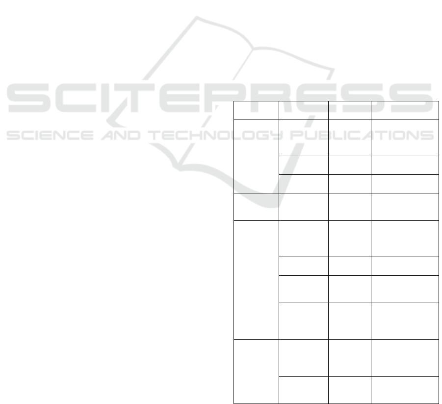
presented in table-1.
Table 1: Area of Sumatera Utara Province MPA
District /
City
MPA’s
Name
Area (ha) Legal Basis
Nias Utara MTP.Sawo
Lahewa
29.230,85 Kepmenkp-RI No
54/ KEPMEN-
KP/2017 dated 22
Decembe
r
2017.
MPA
P.Wunga
12.915,93 Space allocation
RZWP3
K
-SU
MPA
Kec.Alasa
1.332,68 Space allocation
RZWP3
K
-SU
Labuhan
Batu
LPATerubu
k Fish
7.210,41 Kepmenkp
No.54/KEPMEN-
KP/2017
Nias
Selatan
RMPA Nias
Selatan
56.000,00 Gov. decree No.
188.44/629/KPTS/
2017 dated 21
Novembe
r
2017
RMPA
P.Simuk
8.146,5 Space allocation
RZWP3
K
-SU
RMPA
P.Batu
Timu
r
44.293,62 Space allocation
RZWP3K-SU
RMPALahu
sa and
Toma
District
17.947,91 Space allocation
RZWP3K-SU
Tapanuli
Tengah
RMPA
Tapanuli
Tengah
81.243,00 Gov. decree No.
188.44/629/KPTS/
2017 dated 21
Novembe
r
2017
RMPA
Sorkam
Bara
t
1.763,71 Space allocation
RZWP3K-SU
ICNRSD 2018 - International Conference on Natural Resources and Sustainable Development
160
District
Serdang
Bedagai
RMPA
Serdang
Bedagai
3.786,02 Gov. decree No.
188.44/629/KPTS/
2017 dated 21
November 2017/
Space allocation
RZWP3
K
-SU
Nias RMPA
Kec.Bawo
Lato
4.986,84 Space allocation
RZWP3K-SU
RMPA Gido
and
Idanogawo
District
4.502,56 Space allocation
RZWP3K-SU
Nias Barat RMPA
Sirombu
Dist.
27.409,80 Space allocation
RZWP3K-SU
Langkat RMPA
Secanggang
District
1.809,66 Space allocation
RZWP3K-SU
Batubara RMPA
Tj.Tiram
District
3.804,86 Space allocation
RZWP3K-SU
Mandailing
Natal
RMPA
Mandailing
Natal
1.405,99 Space allocation
RZWP3K-SU
Tapanuli
Selatan
RMPA
Muara
Bt.Toru
District
7.724,46 Space allocation
RZWP3K-SU
RMPA
Tapanuli
Selatan
7.724,46 Space allocation
RZWP3K-SU
Total 323.238,90 Determination,
reserve, allocation
3.2 Authority Transfer Issue
Based on the research data, the transfer of MPA
management authority from the District / City
Government to the Sumatera Utara Provincial
government caused the Provincial Government's
burden to increase. This transfer of authority raised
the problem of marine conservation management in
Sumatera Utara Province, including:
(1) There is no MPA institution and management
The Nias District Government since 2007 has set an
MPA of 29000.00 ha, for the protection of
sustainable fisheries, marine tourism of coral reefs
and mangroves. In 2008, there was a division of
Nias District into Nias District and Nias Utara
District. Most MPA areas that have been established
are in Nias Utara District, so there is no management
of MPA anymore. When MPA management was
transferred to the Province, the Sumatera Utara
Provincial Government reserved an MPA of
29230.85 ha. Based on the Decree of the Minister of
Maritime Affairs and Fisheries of the Republic of
Indonesia Number 54 / KEPMEN-KP / 2017 dated
December 22, 2017 stipulates MPA Sawo-Lahewa,
Nias Utara as a Marine Tourism Park.
The MPA's function is to protect, conserve,
utilize fisheries potential and important ecosystems
such as coral reefs, mangroves and seagrasses and
important species such as sea turtles, dolphins, marta
rays, napoleon, lola, dugong, clams, sharks, whales,
sea bamboo, bahar roots, goat's head, triton trumpet,
sea cucumber, and hollow nautilus. MPA serves to
support the development of water tourism. This
MPA is managed with 5 zoning, in the form of
MPA-1 covering 2485.34 ha, MPA-2 covering
12562.50 ha, MPA-3 covering 7371.09 ha, MPA-4
covering 3948.80 ha and MPA-5 covering 2863, 12
ha.
In the decree stipulating the Sawo-Lahewa MPA,
it was stated that the management was handed over
to the Sumatera Utara Provincial Government.
Although the Central Government has determined it
as MPA Sawo-Lahewa since 2017, the Provincial
Government has not established institutional,
management, and budgeting activities. Thus, since
the establishment of the MPA in 2007, from 2008 to
2018, there was no MPA management at all. MPA
areas such as no man's land, no conservation
functions are carried out. Conditions like this, cause
a decrease in coral reef cover, an increase in the
degradation of the marine environment and a decline
in the economic and social community around the
MPA.
(2) There is no new MPA determination
The District Government of Tapanuli Tengah since
2007 has managed an MPA of 81243.00 ha, The
Nias Selatan District Government has managed
MPA since 2008 covering an area of 56,000.00 ha
and the SerdangBedagai District Government has
managed MPA since 2008 covering an area of
1240.35 ha. Management has been stalled since
2014 because the conservation authority was taken
over by the province.The administrative activities
carried out by the Sumatera Utara Provincial
Government in the form of MPA reserves covering
an area of 138483.40 ha with the Sumatera Utara
Governor Decree Number 188.44/629/KPTS/2017
dated November 21, 2017.
The Sumatera Utara Provincial
Government, which has received the responsibility
for MPA management since 2014, has not been able
to manage the MPA because there is no stipulation.
Therefore, there is no MPA management in the
districts of Tapanuli Tengah, Nias Selatan and
SerdangBedagai since 2014. With conditions
without management, an open access area, it can be
The Effect of Transfer of Conservation Authority towards Marine Protected Areas in Sumatra Utara Province-Indonesia
161

ascertained that there has been a decline in coral reef
cover, environmental damage and a decline in the
economic and social conditions of the community
around the MPA.
(3) The MPA proposal was abandoned
The transfer of authority to manage MPA from the
District Government to the Provincial Government
based on Law No. 23 of 2014 caused the proposal to
establish MPAs become abandoned in various
districts / cities in Sumatera Utara Province. The
research results from the field, Batubara District,
Sibolga City and Mandailing Natal District have
prepared new MPA proposal documents. With the
transfer of this authority, the District / City
Government is not authorized to proposing the
MPA. Therefore, Sumatera Utara Provincial
Government should follow up on preparing the MPA
proposal document. However, until 2018, the file of
the proposed district / city MPA has no follow-up
from the Provincial Government.
(4) The abandonment of the proposed Limited
Protection Area
The Sumatera Utara Provincial Government has a
Terubuk Fish (Tenualosailisha) Limited Protection
Area, in LabuhanBatu based on Decree of the
minister of maritime affairs and fisheries No.
34/KEPMEN-KP/2016 dated August 2,
2016.Although it has been established since 2016,
until 2018 there is no institution, management,
funding, and conservation activities in the field. In
addition, the District / City Government have also
compiled a proposal for a limited protection area for
Batak Fish and KerangAnakDara in Asahan District,
protection of Sea Turtles and Oysters in Tapanuli
Tengah District and others. Because the authority of
the conservation proposal has been transferred from
the District / City Government to the Provincial
Government, Sumatera Utara Provincial
Government should continue to propose a limited
protected area for fish species. The results of the
study showed that the proposed limited protection
area has not been continued by the Sumatera Utara
Provincial Government.
(5) There is no private MPA coaching
The transfer of the authority of conservation
management from the District / City Government to
the Provincial Government led to the formation of
private conservation institutions managed by small-
scale communities such as "the animal loses its
mother". District / city governments do not want to
take care of because it was not their main tasks and
functions anymore while the Provincial Government
does not have data, relations, development budget
and the distance between the provincial capital and
conservation locations in rural area which was far
enough. Because there is no funding assistance and
coaching, the private MPA has stagnated
management. The conservation management
community group expects guidance, placement of
extension workers / instructor and funding
assistance.
4 CONCLUSION
The Sumatera Utara Provincial Government through
the Department of Marine and Fisheries is not ready
to accept the delegation of the authority in the field
of conservation from the District / city Government
in accordance with Law No 23 of 2014 concerning
Local Government. The transfer of authority does
not make MPA management better, the MPA
happens to be increasingly neglected. Negative
impact of the transfer of conservation authority from
District / City Government to Sumatera Utara
Province, in the form of:
a. The Sumatera Utara Provincial Government is
obliged to manage MPAs that have been
determined by the Central Government: (1)
Sawo-Lahewa Nias Utara MPA in 2017
(established in 2007) and (2) Terubuk Fish
Limited Protection Area in Labuhan Batu
District 2016. But until 2018 it has not been
managed, there is no institution, supervision
management model, budgeting, and
conservation implementation in the
conservation area.
b. Sumatera Utara Provincial Government has
reserved 3 new MPAs in 2017 but because the
Central Government has not yet been legalized
it, the Tapanuli Tengah MPA (established in
2007), Nias Selatan (2008) and SerdangBedagai
(2008) cannot be managed by the Sumatera
Utara Provincial Government.
c. Sumatera Utara Provincial Government has not
followed up on the MPA's proposal and the
proposed Limited Protection Area which has
been delayed due to the transfer of management
authority from the District / City Government to
the Provincial Government.
d. Sumatera Utara Provincial Government has not
recorded private MPAs managed by the
community, as well as no guidance, assistance
and funding assistance.
ICNRSD 2018 - International Conference on Natural Resources and Sustainable Development
162

REFERENCES
Anonim. 2017. Kondisi Terumbu Karang Indonesia
Mengkhawatirkan. Republika.Online. . 07 June 2017
23:03 WIB.
https://www.republika.co.id/berita/nasional/umum/17/
06/07/or6px4361-kondisi-terumbu-karang-indonesia-
mengkhawatirkan
Agbeja.Y.E.2017. Marine protected area: Prospective Tool
For Ecosystem Based Fisheries Management in
Nigeria.International Journal of Biodiversity and
Conservation. Vol. 9(6), pp. 158-166, June 2017
Ban.N.C, Louisa S. Evans, Mateja Nenadovic and
Michael Schoon. 2015. Interplay of Multiple Goods,
Ecosystem Services, and Property Rights in Large
Social-Ecological Marine Protected Areas.Ecology
and Society 20(4): 2
Briggs.J, Stacy K. Baez, Terry Dawson, Bronwen Golder,
Bethan C. O'Leary, Jerome Petit, Callum M. Roberts,
Alex Rogers, dan Angelo
Villagomez.2018.Recommendations to IUCN to
Improve Marine Protected Area Classification and
Reporting.February 6th 2018. Submitted by: The Pew
Bertarelli Ocean Legacy Project
Clements.C, Victor Bonito , Rikki Grober-Dunsmore,
Milika Sobey.2012. Effects of Small, Fijian
Community-Based Marine Protected Areas on
Exploited Reef Fishes. Marine Ecology Progress
Series. Vol.449: 233-243,2012.
Charles.A, Lena Westlund, Devin M Bartley, Warrick J
Fletcher, Serge Garica, Hugh Govan and Jessica
Sanders. 2016. Fishing livelihoods as key to marine
protected areas: insights from the World Parks
Congress. Aquatic Conservation : Marine and
Freshwater Ecosystems. 26 (Suppl. 2): 165–184
(2016)
DKP-SU.2016.Statistik Pengelolaan Wilayah Pesisir dan
Pulau-Pulau Kecil Provinsi Sumatera Utara 2016.
Medan. Dinas Kelautan dan Perikanan Provinsi
Sumatera Utara
Heinonen,M.2013. Applying IUCN Protrcted Area
Management Categories in Finland. Final version
approved by the National IUCN Committee of
Finland, June 17
th
, 2013. IUCN
http://www.ilo.org/dyn/natlex/natlex4.detail?p_lang=en&p
_isn=77116
https://www.ecolex.org/details/legislation/law-no-272007-
regarding-the-management-of-coastal-area-and-isles-
lex-faoc107226
Islam.G.M , Shzee Yew Tai , Mohd Noh Kusairi , Shuib
Ahmad , Farhana Mohd Noh Aswani , Muhamad
Khair Afham Muhamad Senan , Ali Ahmad. 2017.
Community perspectives of governance for effective
management of marine protected areas in Malaysia
.Ocean & Coastal Management (2017) 34-42
Jentoft.S, Jose J. Pascual-Fernandez, Raquel De la Cruz
Modino, Manuel Gonzalez-Ramallal , Ratana
Chuenpagdee. 2012. What Stakeholders Think About
Marine Protected Areas: Case Studies from. Springer
Science + Business Media, Hum Ecol DOI
10.1007/s10745-012-9459-6, Februari 2012
Leenhardt.P, Bertrand Cazalet, Bernard Salvat, Joachim
Claudet, François Feral.2014. The rise of large-scale
marine protected areas: Conservation or geopolitics?
Ocean & Coastal Management- XXX (2013) 1-7
Machumu,M.E and Amararatne Yakupitiyage. 2013.
Effectiveness of Marine Protected Areas in Managing
the Drivers of Ecosystem Change: A Case of Mnazi
Bay Marine Park, Tanzania. Jurnal Ambio. 2013 Apr;
42(3): 369–380.
Pascal.N.2011. Cost-benefi t analysis of community-based
marine protected areas: Five case studies in Vanuatu.
SPC Fisheries Newsletter - January/April 2011
Setyawati.2014.Managing Marine Protected Areas in
Indonesia. Jurnal Marine Biological Associated of
India, 56 (1), 13-18, January-June 2014
Sumaila.U.S, Sylvie Guenette, Jackie Alder, David Pollard
dan Ratana Chuenpagdee.2012. Marine Protected
Area: Guiding Principles and Benefits. WWF
Undang-undang Nomor 32 tahun 2004 Tentang
Pemerintah Daerah = Law No. 32/2004 concerning
Regional Administration
Undang-Undang Nomor 27 tahun 2007 Tentang
Pengelolaan Wilayah Pesisir dan Pulau-Pulau Kecil
=Law No. 27/2007 regarding the Management of
Coastal Area and Isles
Waltter,N. 2017. Marine Protected Area Management in
the Finnish Gulf of Bothnia Connections
BetweenUunderwater Nature, Human Activityand
Management. Faculty of Business and Science
University Centre of the WestfjordsMaster of
Resource Management: Coastal and Marine
Management Ísafjörður, May 2017
Wilhelm.T.A, Charles R.C,Sheppard; Annel S.Sheppard,
Carlos F Gaymer, John Parks, Daniel Wagner and
Naia Lewis.2014. Large marine protected areas –
advantages and challenges of going big.2014.Aquatic
Conservation: Marine and Freshwater Ecosystems.
24(Suppl. 2): 24–30 (2014)
The Effect of Transfer of Conservation Authority towards Marine Protected Areas in Sumatra Utara Province-Indonesia
163
