
New Method of Ground Penetrating Radar for Delineation and
Mapping of Shallow Coal Seam
Eddy Ibrahim
1
, Maulana Yusup
1
and Lilik Hendrajaya
2
1
Department of Mining Engineering, Faculty of Engineering, Universitas Sriwijaya, Palembang, Indonesia
2
Department of Physics, Faculty , Faculty of Mathematical and Natural Sciences,
Institut Teknologi Bandung, Bandung, Indonesia
Keywords: GPR Application, Newly Acquisition and Processing GPR Design, Multi Configuration Antenna,
Shallow Coal Seam
Abstract: This article presents the practical empirical analysis and applied evaluation of the impulse radar method and
shows that significant performance benefits can be achieved in ground penetrating radar applications. These
benefits are successfully demonstrated in field trials of a newly-designed acquisition and processing GPR
system. An original contribution has been made in establishing a method of the measurements of GPR for
coal seam. This enables the maximum penetration depth of a GPR system to be characterized of shallow
coal seam as basic analogue recording radar system with multi-configuration antenna. Similarly, the
resolution is expressed as basic analogue recording radar system with antenna orientation variation which is
also selective with frequency antenna. These expressions prove to be useful to design acquisition and
processing in characterizing GPR performance and could improve data quality, and then could allow
information other than reflector depth for a defined application. A design acquisition of impulse radar
technique is undertaken, which demonstrates the empirics of an impulse radar technique using multi
configuration antenna with fixed offset. It is concluded that a physically realizable newly acquisition
method of GPR has far reaching benefits in the form of higher resolution images from raw data.
1 INTRODUCTION
Under coal outcrop in general there are clay layers.
Coal layering that is not exposed at surface is
usually embosomed by clay layer, above and under
coal seam. In coal exploitation phase, information
about coal thickness, its position, fracture plane and
its water content is highly required. Such
information is required for initial determinations of
topping-off overburden, digging direction and coal
rank. Information of coal seam as well as its
overburden thicknesses can increase efficiency in
digging process because the volume of overburden
layer which must be dug can be estimated.
Currently, intensive boring must be carried out to
know the information and many boring points must
be set up to estimate lateral position of coal and
thickness of its overburden.
This boring step which must be carried out
results in a high production cost. Information about
fracture planes in coal outcrop can serve the purpose
of initial determination of digging direction. At
present in the exploitation stage of coal production,
the blade at bulldozer or bucket at bucket wheel
excavator appears to be dull quickly due to digging
orientation which is perpendicular to fracture planes
in coal seam. Besides the impact of way of the
digging, inefficiency in equipment performance is
generated since the need of fuel increases and
results in higher production cost (Ibrahim et al.,
2004 and Ibrahim, E, 2005).
To obtain the information mentioned above, it is
necessary to apply a method that must fullfill certain
criteria due to physical properties of coal that is easy
to fall into pieces and does not have pores (Van
Krevelen, 1993). Such criteria are for example: not
destructive since the nature of coal is fragile, high
resolution which is required to obtain information of
water content and fracture plane in coal, continuous
and quick in operation which is needed for overall
information in coal seam. Ground-penetrating radar
(GPR) represents one of altenative and promising
methods to overcome such problems. Moreover, the
application of GPRfor coal exploration is so far not
Ibrahim, E., Yusup, M. and Hendrajaya, L.
New Method of Ground Penetrating Radar for Delineation and Mapping of Shallow Coal Seam.
DOI: 10.5220/0009898400002480
In Proceedings of the International Conference on Natural Resources and Sustainable Development (ICNRSD 2018), pages 107-111
ISBN: 978-989-758-543-2
Copyright
c
2022 by SCITEPRESS – Science and Technology Publications, Lda. All rights reserved
107
in standard form, especially in the acquisition mode
and its data processing (Annan, 2001).
This article describes an attempt to optimally
image layered coal seams by setting up a standard
design of acquisition modes of GPR and its data
processing.
2 METHODS
In order to get a reliable result to set a new
procedure in designing acquisition and its data
processing for shallow layered coal, 3 stages of
investigation were established: measurement on coal
samples at laboratory scale, 2D and 3D forward
modeling and field measurement.
2.1 Measurement at Laboratory Scale
Measurements in laboratory were carried out on coal
samples taken from coal outcrop at Tanjung Enim,
South Sumatra, Indonesia to determine their
dielectric constants at 1GHz frequency. This was
done using reflection principle with 1GHz antenna
frequency. The resulted data were then processed to
determine dielectric constant values. To obtain
reliable results, some processing steps were carried
out: spiking deconvolution, dewow, declip, set-time
zero, fk-filtering, frequency filtering and time to
depth conversion. From the processed data,
dielectric constant values were then determined.
These values of dielectric constants would be used
as input parameter for modelling of high frequency
electromagnetic waves in 2D and 3D.
2.2 2D and 3D Forward Modelling
Using dielectric constants resulting from laboratory
samples and geometry of 2D as well as 3D body, a
forward modelling was carried out. It was
implemented with free-availably GPRMax2D and
GPRMAx3D (Giannopoulos, 2003 and Ibrahim,
2005). It is based on FDTD scheme after Yee
(Yee,1966).
The result of 2 D modelling of coal body
surrounded by clay is as follows (see fig. 1).
Figure 1: Two Dimension (2D) Modeling of coal and
Clay (Ibrahim, 2005)
The position of coal could be determined,
which is based on its signature (fig. 2).
Figure 2: Radargram from the result of execution 2 D
modelling of coal and clay (figure 1) (Ibrahim, 2005)
Figs. 4 and 5 show the results of 3D modelling
as shown in fig. 3.
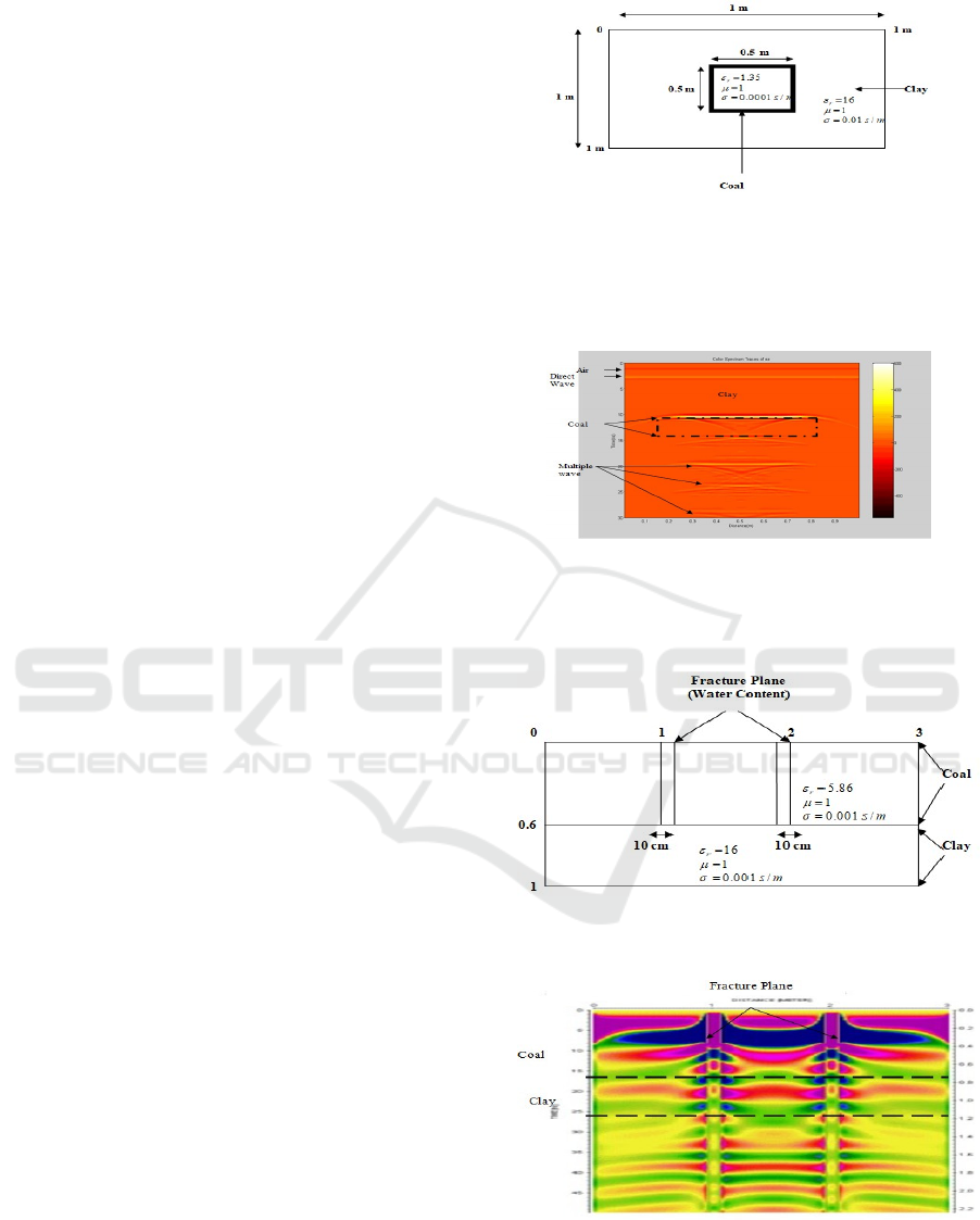
Figure 3: Coal modelling with fracture planes and clay
layer under coal (Ibrahim, 2005)
Figure 4. Radargram for x direction polarization (xx
mode) from the result of execution coal modelling with
fracture planes and clay layer under coal (figure 3)
(Ibrahim, 2005)
ICNRSD 2018 - International Conference on Natural Resources and Sustainable Development
108

Figure 5: Radargram for y direction polarization (yy
mode) from the result of execution coal modelling with
fracture planes and clay layer under coal (figure 3)
(Ibrahim, 2005)
It can be seen that fracture planes could be
determined, in which xx configuration gave more
clearer radargram compared with that of yy
configuration.
2.3 Measurement of Limited Field
Scale
Measurement on coal outcrop (fig. 6) was conducted
at Bukit Asam mine shaft, Tanjung Enim, South
Sumatra with various antenna orientation (fig. 7).
Figure 6: Measured coal outcrop (Ibrahim, 2005)
Figure 7: Acquisition mode of reflection profiling using
bistatic antenna with centre frequency of 100 MHz direct
on coal outcrop (Ibrahim, 2005)
GPR campaign with 100 MHz was assigned.
Three different antenna orientations (yy, xx and yx
configurations) were used. The height of the antenna
for 3 different configurations were the same, in that
the antenna stood direct on outcrop. (Ibrahim et.al,
2004)
The acquired data were then processed with
processing steps similar to the steps applied on
radargram from measurement in laboratory. In
addition, influences of water content and fracture
planes detected by each variation of antenna
orientation (yy, xx and zx configurations) are also
shown in the results.
For verification of the results of acquisition and
processing steps that we propose here, we also
applied them for the data taken from coal outcrop
with same coal rank but different physical properties
laterally.
3 RESULTS
A forward modelling of 2D or 3D body with
dielectric constant for coal with various ranks as
input data results radargram is shown in figs.2, 4 and
5. In general, 2D modelling provided information of
clear coal position, which was based on signature in
the form of waveform. To define the existence of
fracture planes, 3D modelling should be applied. In
some cases numerically, multiple effects always
existed in data since the value contrast of dielectric
constant between coal and clay was very large.
Practically such an effect was also recognizable in
raw data. Determination of dielectric constant of
coal samples was carried out by using GPR antenna
with 1 GHz frequency. Similar processing steps to
data acquired from field measurement were applied
to data from laboratory measurement.
Measurement with yy configuration could
produce information of thickness of coal seam and
various water content in coal seam. (fig. 8).
Figure 8: Profile of acquired GPR records after processing
at coal outcrop in yy mode (Ibrahim, 2005)
New Method of Ground Penetrating Radar for Delineation and Mapping of Shallow Coal Seam
109
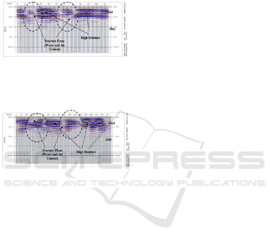
Measurement with xx configuration provided
information of the existence of fracture planes and
water content variation in coal seam as well as its
thickness.(fig. 9)
Figure 9: Profile of acquired GPR records after processing
at coal outcrop in xx mode Ibrahim, 2005)
Information of fracture planes and water content
could be extracted from the measurement with yx
antenna configuration, but that of the coal seam
thickness could not be clearly determined (fig. 10).
Figure 10: Profile of acquired GPR records after
processing at coal outcrop in yx mode (Ibrahim, 2005)
For implementation to real condition of field, yy
configuration showed the results of accurate
measurement of various coal positions and geometry
on various field conditions and locations with
reasonable results. Information of the thickness and
water content extracted from the measurement using
multi-configuration as applied in this investigation
could be validated with the result from direct
measurement (Ibrahim et al., 2004). In addition,
some techniques in the interpretation phase are a
valuable tool to aid in the interpretation. Windowing
attribute could be applied to determine variation in
water content laterally using various antenna
configurations (yy, xx and yx configurations) as well
as to distinguish water content from coal with 2
different ranks laterally on the basis of amplitude
values. High value of amplitude intensity is
associated with high water content and vise versa
(Ibrahim, 2005).
The thing there proved with measurement at
different positions and coal dimension at location
was different from accountable result. Information
of thickness and water content from coal outcrop by
using measurement of this way its (the result could
be validated with the result of direct measurement
analysis) (result of measurement of outcrop
geometry and result of laboratory analysis from the
sample taken at the outcrop) (Ibrahim, 2005).
Window attribute (interval of Amplitude) was
applicable to determine lateral variation of coal water
content good to antenna; configuraton variation (way
of yy, way of xx or way of yx) also to differentiate
water content of two coal ranks which are different
laterally based on values of amplitude. High
amplitude intensity value is associated with high
water content while low amplitude intensity value is
associated with low water content (Ibrahim, 2005).
4 CONCLUSIONS
It is concluded that the results from 2D and 3D
forward modelling are generally in concordance
with the results of field measurement. Such a
modelling can therefore be made as an aid tool to
design field measurement in order to achieve an
optimal result. This optimalisation is realized in the
form of determination of position and orientation of
direction of the antenna and steps of which need to
be performed regarding data processing. It includes
determination of signature coal in radargram,
elimination of direct wave and multiple reflection
and determination of the use of antenna with
appropriate selected frequency and procedure to
analyse the result of data processing. From coal
physical aspect, it needs to be recognized whether
the direction of fracture plane is approximately
parallel or perpendicular to strike. The information
can be extracted with the use of antenna
The results of field measurement data indicate
that the information of fractureplane can be
extracted using yx-configuration. Such information
can not be obtained using 2D and 3D forward
modelling that excludes changes of EM wave
polarisation after being reflected by conductive
medium in its algorithm. Then if the fracture plane
orientation is unknown, measurement of GPR at coal
outcrop must use three configurations, i.e. yy-, xx
and yx-configurations. In general, based on the
results from measurement with various antenna
orientations as well as their data processing and
analysis, it is concluded that GPR is a reliable tool in
the stage of coal exploitation.
Specifically this research gives a scientific
contribution from the use of GPR in coal
exploitation phase, which introduces a new
procedure in data acquisition and processing to
ICNRSD 2018 - International Conference on Natural Resources and Sustainable Development
110

obtain structural information, i.e. layering and
fractureplane and information of lithology (water
content and coal rank). A GPR survey for coal
exploitation should be designed using three different
antenna orientations: xx, yy and yx in the case that
fracture plane orientation is unknown. In the case
that fracture plane orientation is recognized, survey
line using xx antenna orientation is sufficient to be
carried out. The orientation of survey line is
arranged to be perpendicular to the fracture plane
orientation.
This investigation is very important in coal
exploitation since the application of GPR in coal
mining has been very limited so far. This is due to
the low dielectric contrast between the coal seam
and surrounding host rocks.
ACKNOWLEDGEMENTS
We thank PTBA (Perusahaan Tambang Batubara,
Bukit Asam) for granting permission to publish this
paper. We wish to express our gratitude Sriwijaya
University and Faculty of Engineering Sriwijaya
University for the supportive funding of this
research and sponsorship
REFERENCES
Annan A.P., 2001. Ground penetrating radar, workshop
notes, sensors & software. Ontario, Canada.
Giannopoulos. A., 2003. G
PR
M
AX
2D/3D user’s manual
version 1.5, University of Edinburgh, School of
engineering and electronics, institute for infrastructure
and environment, Crew building, The King’s
buildings, Edinburgh, EH9 3JN, Scotland.
Ibrahim, E, Hendrajaya, L., Fauzi, U., Handayani, G.,
Islam, S., 2004. Determination of geometry and
bedding plane orientation in coal seam use of GPR
method and presented a poster presentation in session
T08.04, “Magnetotellurics” at 32
nd
International
Geological Congress, Florence, Italy, Expanded
abstract, August, 27, 2004.
Ibrahim, E., 2005, Study on the Use of Multi-
configuration GPR in the exploitation stage of layered
Coal (case study at Coal Mining Shaft Bukit Asam,
Tanjung Enim, South Sumatra), PhD thesis, Institut
Teknologi Bandung, Indonesia.
Van Krevelen D.W., 1993. Coal, typology-chemistry-
physics-constitution, Coal science and technology,
Elsevier chapter XVIII (3), 373-399.
Yee, K.S., 1966. Numerical solution of initial boundary
value problems involving Maxwell’s equation in
isotropic media. IEEE transactions on antennas and
propagation 14 pp. 302-307.
New Method of Ground Penetrating Radar for Delineation and Mapping of Shallow Coal Seam
111
