
Morphotectonic Analysis between Crete and Kasos
D. Lampridou
1
, P. Nomikou
1
, M. Alexandri, D. Papanikolaou
1
, C. Hübscher
2
,
Th. Ioannou
1
, P. Sorotou
1
and L. Ragia
3
1
Department of Geology and Geoenvironment, National and Kapodistrian University of Athens,
Panepistimioupoli Zografou, 15784 Athens, Greece
2
Institute of Geophysics, Center for Earth System Research and Sustainability, University of 11 Hamburg,
Bundesstraße. 55, D-20146 Hamburg, Germany
3
Natural Hazards, Tsunami and Coastal Engineering Laboratory, Technical University of Crete, Chania, Greece
Keywords: Swath Bathymetry, Crete and Kasos, Morphotectonic Analysis.
Abstract: The morphotectonic structure of the offshore area lying between Crete and Kasos is studied on the basis of
new detailed bathymetric data. The resulting bathymetric map is presented. Qualitative analysis of
morphological slope values, as well as the analysis of the watershed at the eastern part of Crete, confirms that
the current seabed topographic relief reflects intense tectonic activity. The high morphological slope values
indicate well-defined morphotectonic features, which mainly trend SW-NE and, secondarily, SSW-NNE. The
main large-scale tectonic structures trend SW-NE correspond to the marginal faults that bound the Crete-
Kasos basin. The overall basin geometry is an elongated rectangular which is divided into seven sub-basins,
and the deepest one (2800m) is located at the eastern part of the area. Moreover, the complex regime of the
seafloor includes submarine canyons, landslides and a well-defined slump with vertical displacement more
than 400m.
1 INTRODUCTION
The importance for improving our understanding of
geohazards is evident from global events. Globally,
disasters affected 150 million people and inflicted an
estimated damage of US$ 100-150 billion over a few
years as documented by various reports
(http://www.unisdr.org).
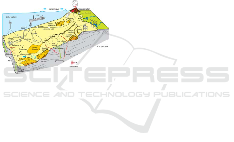
Kvalstad (2007) defined geohazard in the offshore
domain, as ‘‘local and/or regional site and soil
conditions having a potential of developing into
failure events causing loss of life or damage to health,
environment or field installations’’. Examples of
such hazards include earthquakes and submarine
landslides, iceberg scouring of the seabed, and gas
migration that can lead to locally overpressurized
sediments and potential terrain instability and/or
blowouts (Fig.1). Secondary effects such as tsunamis
(either triggered by earthquakes or landslides) also
need to be considered, as both their genesis and
propagation are strongly controlled by seafloor
morphology (Chiocci et al.,2011). Hence, there is an
urgent need to determine better the development of
geohazards and inherent risks, and an adequate
response to them. This need is also accentuated by
the increased vulnerability of coastal areas to
earthquakes because of rapid growth of urban centres.
Tsunamis are a low frequency natural hazard with
potentially catastrophic consequences. The
knowledge of their recurrence is of critical
importance for the development of models and
scenarios adapted to local and regional conditions,
thus giving support to the design of warning systems
and mitigation measures.
The Hellenic subduction zone (HSZ) has
historically generated among the most devastating
earthquakes, and by far the most damaging tsunamis
in the entire Mediterranean region. Historic
earthquakes along the HSZ, particularly along the
Crete segment, attest to some degree of coupling on
the plate interface(Shaw et al., 2008; Guidoboni and
Comastri, 1997; England et al., 2015).
To properly assess and describe hazards
complexity and manageability it is required an
understanding of the broader geologic, sedimentary
and tectonic variability. Therefore, multi-disciplinary
surveys aimed at detecting and mapping geohazards,
are being conducted.
The advent of multibeam sonar (MBS)
technology has allowed imaging of the seafloor with
unparalleled resolution, spatial coverage and
142
Lampridou, D., Nomikou, P., Alexandri, M., Papanikolaou, D., Hübscher, C., Ioannou, T., Sorotou, P. and Ragia, L.
Morphotectonic Analysis between Crete and Kasos.
DOI: 10.5220/0006387201420150
In Proceedings of the 3rd International Conference on Geographical Information Systems Theory, Applications and Management (GISTAM 2017), pages 142-150
ISBN: 978-989-758-252-3
Copyright © 2017 by SCITEPRESS – Science and Technology Publications, Lda. All rights reserved
precision and today offer the most cost effective way
to explore the ocean floor (Hughes et al. 1996,
Chiocci et al.2011).
High resolution swath data obtained during
oceanographic cruise in the framework of FP7
“ASTARTE: Assessment, Strategy and Risk
Reduction for Tsunamis in Europe-ASTARTE’’
project in the South Aegean Sea. The aim of this
paper has been the fault recognition by applying
morphostructural analysis, which was based on the
quantitative interpretation of the seafloor topography,
the slope distribution and the drainage pattern
development in the offshore area lying between Crete
and Kasos.
Figure 1: Cartoon summarizing the seafloor features linked
to potentially hazardous geological processes (Chiocci et
al., 2011).
2 REGIONAL SETTING
The Hellenic subduction zone is the largest, fastest
and most seismically active subduction zone in the
Mediterranean, where the African slab subducts
beneath Crete at a rate of ~36mm yr
-1
(McCluscky et
al., 2000; Reilinger et al., 2006). The subduction rate
greatly exceeds the convergence between Africa
(Nubia) and Eurasia (5-10 mm yr
-1
) because of the
rapid SW motion of the southern Aegean itself,
relative to Eurasia ( McKenzie 1972; Reilinger et al.,
2006). The surface morphology of the subduction
system is obscured beneath a sedimentary section up
to 10km thick overlying the ocean crust, which is
deformed in a broad accretionary prism south of
Crete, known as the Mediterrannean Ridge
accretionary complex ~150 km south of Crete (Le
Pichon et al.1979, Kastens, 1991, Chamot-Rooke et
al., 2004). A dramatic 2-3 km high, south-facing
bathymetric scarp extends in an arc between the
Peloponnese and Crete, splitting into three branches
south of Crete, and continuing east up to Rhodes
constituting Ptolemy, Pliny and Strabo trenches
(McKenzie 1978; Le Pichon et al.1979). Although
this scarp is referred as the Hellenic Trench, the
southern margin of the continental Aegean
lithosphere is located about 100 km south of the
Cretan coast (Bohnhoff et al., 2001) and it is possible
to follow the subduction zone through a well-defined
Benioff zone to a depth of 150-180 km below the
central Aegean Sea (Papazachos et al., 2000). The
Ptolemy, Strabo and Pliny Trenches, despite their
names, are not trenches in the plate-tectonic sense but
probably represent the outcrop of major faults within
the deforming sedimentary wedge on top of the
Nubian plate (Shaw et al., 2008; , Shaw,B.,
Jackson,J., 2010, Huguen et al., 2001; Le Pichon X,
Angelier J. 1979; Kreemer C, Chamot-Rooke N.
2004; Mascle et al., 1986; McKenzie 1978; Gallen et
al., 2104). While the Hellenic Trench is generally
considered to represent the outcrop of a reverse fault,
the Pliny and Strabo Trenches have been interpreted
as the expressions of normal faulting ([Gallen et al.,
2014), strike-slip faulting (Mascle et al., 1982;
Ozbakir et al., 2013), reverse faulting (Shaw and
Jackson, 2010; Jongsma 1977) and various
combinations of these (e.g. Huguen et al., 2001;
Mascle et al 1986, Peters and Huson 1985; tenVenn
et al., 2009).
Nowadays, the Hellenic arc is associated with
moderate arc-parallel extension and strong
compression perpendicular to it (Kahle et al., 1998).
The geometry of tectonic troughs offshore Crete
reflects a two-tier deformation mechanism at depth,
in which oblique extension predominates in the upper
10-15km of the crust and oblique compression
predominates underneath this limit (Kokkinou et al.
2012). This obliquity has been associated with rapid
exhumation of basement units and intense uplift of
the forearc region where Crete, Gavdos, Kasos and
Karpathos islands are located (Le Pichon et al., 2002).
The Hellenic Subduction Zone (HSZ) produced two
M~8 earthquakes, both near Crete, during the > 2000
year historic record, AD 365 and AD 1303 (Shaw et
al., 2008; Guidoboni and Comastri, 1997; England et
al., 2015). Both caused severe damage from shaking
and the resulting tsunamis caused major damage
around the Eastern Mediterranean. The precise
locations and mechanisms of these ancient events are
not well known. The AD 365 event is thought to have
occurred on a splay fault extending from the plate
interface towards the surface below southwestern
Crete (Shaw et al., 2008). Large uplift recorded by
shorelines in western Crete has been interpreted as
due to coseismic slip on the splay fault. The location
Morphotectonic Analysis between Crete and Kasos
143
of the AD 1303 event is constrained only from
damage reports and is believed to be located near
southeast Crete (Guidoboni and Comastri, 1997).
Significantly, the AD 1303 event caused no
observable shoreline uplift, although a substantial
tsunami was well recorded (England et al., 2015).
Noteworthy are the catastrophic events in AD 365
and AD 1303, during which Alexandria and the rest
of the Nile Delta were flooded extensively by the
tsunamis triggered by these events (Ambraseys
2009).
The offshore area between Crete and Kasos is
characterised by the large number of poorly
characterized bathymetric scarps that cross the
region. Each of these is potentially associated with a
fault capable of generating a rare, high-magnitude,
earthquake. Unlike the other parts of the Hellenic
plate boundary, however, there is no possibility of
detecting past earthquakes from on-shore geological
evidence. The principal faults lie far enough from the
shore that no detectable uplift of shorelines would be
expected (Howell et al. 2015), making a detailed
marine survey essential.
According to England et al., 2015, the Pliny
Trench is the most probable source of a tsunamigenic
earthquake in HSZ. Nevertheless, large earthquakes
occurring along Strabo and Ptolemy Trenches, can
trigger tsunamis.
Although the Hellenic system represents the most
significant seismic and tsunami hazard in the
Mediterranean region, its kinematics and associated
hazards remain uncertain because available GPS data
are not sufficiently precise and spatially distributed to
determine the distribution of strain accumulation on
the plate boundary faults (England et al., 2015). Many
important details of the kinematics-dynamics of the
Hellenic subduction zone remain poorly understood
and under debate.
3 METHODOLOGY
3.1 Data Acquisition
Data used in this paper have been obtained onboard
R/V Med Surveyor in the framework of the research
program “ASTARTE: Assessment, Strategy and Risk
Reduction for Tsunamis in Europe-ASTARTE’’.
Swath bathymetry data were acquired using
multibeam echosounder Elac’s SeaBeam 3030, which
operates in the 30 kHz band and incorporates a multi-
ping capability (two swaths per ping). Data were
logged with HYPACK. The collected multibeam data
have been extensively processed by means of data
editing, cleaning of erroneous beams, filtering of
noise, processing of navigation data and interpolation
of missing beams, using the open-source software
MB-SYSTEM, and then gridded with grid spacing of
50m. Analyses and representation of bathymetric data
were performed with ArcGIS 10.1 software and
Global Mapper v.16.
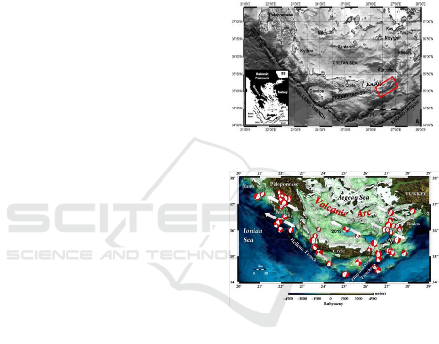
Figure 2: General map of the area (Kokinou et al., 2012),
the red box corresponds to the study area.
Figure 3: All earthquake focal mechanisms, with Mw>4.0
and focal depths less than 25 km, are plotted which reflect
the accommodation of extension within the material of the
overriding southern Aegean Sea, above the subduction
interface (Kiratzi, 2013).
3.2 Bathymetry Map
The resulting slope-shaded bathymetric map was
compiled at 1:300,000 scale. This map permits a first
description of the overall topography of the seafloor
as well as the mapping of the major morphotectonic
structures (Fig.4a).
3.3 Slope Map
The bathymetric map of the area was analysed as far
as the slope distribution is concerned. The slope
distribution map shows the distribution of slope
GISTAM 2017 - 3rd International Conference on Geographical Information Systems Theory, Applications and Management
144

values within the study area distinguished in four
categories a) areas of mean morphological slope 0⁰-
5⁰, b) areas of 5⁰-20⁰ , c) areas of 20⁰-40⁰ d) and
areas of >40⁰. This classification of the slope
magnitude will illustrate the zones where there is an
abrupt change of slope, reflecting possible positions
of active tectonic zones in contrast with zones with
negligible change of slope, which reflect flat-lying
areas such as submarine terraces or basinal areas
(Fig.4b).
3.4 Slope-aspect Map
The combined slope-aspect map captures both the
direction of the slopes and their steepness, illustrating
the overall geometry of the area and changes in the
relief orientation which may be attributed to active
tectonic structures. The direction of the
slope(degrees) is expressed in hue and the steepness
of the slope (degrees) is expressed by its saturation
(Fig.4c).
3.5 Watershed
Submarine canyons, small gullies and stream network
were extracted for the entire area employing the in-
built hydrology tools. When extracting the drainage
pattern the following points have to be taken into
account : a) the flow accumulation output grid was
produced by applying a threshold upstream cell
number of 200, b) multibeam artefacts can result in
the interruption of streams or the generation of
spurious ones.
4 RESULTS
Synthetic Morphotectonic Map of the under study
area was carried out by means of the combined use
of: (a) Seabed Digital Elevation Model (SDEM), (b)
Slope Distribution Map, (c) Slope-aspect Map and (d)
Drainage Pattern Map. The composition of the digital
modelling in conjunction with the regional
geodynamic setting, allows the identification of the
main morphological discontinuities and lineaments
that result from morphotectonic.
The bathymetric map reveals a rather rough
seafloor topography where flat-lying areas alternate
with rough morphology. Two prominent fault zones
form the general structure of the area. The first fault
zone strikes SW-NE comprising the marginal faults
that delineate the central subsided area. The second
fault zone, strikes SSW-NNE and crosscuts the first
one. The topographic difference along the marginal
faults, which apparently correlates with the fault
throw, ranges between 1200m up to 1500m. The
northern marginal fault presents its greater
topographic difference at the western and far eastern
part, while the southern marginal fault at its eastern
part. This is possibly linked to the different structural
deformation of the area. The basinal area that is
bounded by the previous SW-NE identified fault
zone, is divided into seven elongated sub-basins,
parallel to the alignment of the marginal faults. The
sub-basins are lying at 2200m, 2500m, 2600m and
2800 water depths respectively. The eastern basin is
a simple geometric basin with a flat-lying sea bottom
(2800m) at the junction of the two major marginal
fault zones, and its maximum subsidence is
accommodated by the southern marginal fault. The
western part of the basin has a very complex
topographic regime carved by several sub-basins
developed with different geometric shapes at
different water depths and separated by distinct
intermediate submarine ridge with topographic
differences ranging from 150m of meters.
Numerous gullies that dissect the slopes, trending
almost NW-SE, coalesce at several depths ending up
at the seven sub-basins. The most prominent
submarine canyon is the one bounded by the
secondary fault zone that strikes SSW-NNE. Its a U-
shaped rather linear feature and its thalweg depth
ranges between 1300m and 2800m water depth. The
channel walls are asymmetrical and the axis profile
displays a linear morphology (Fig.5).
Submarine landslides were also identified in the
study area by the typical crescent-shape scar. The
most interesting is the one comprising the NW flank
of the linear channel. It is a typical slump with four
distinguishable «steps» at 1500m, 1600m, 1700m
1800m, meaning that the vertical displacement is
approximately 100m. Noteworthy is that this kind of
landslides can trigger tsunamis.
5 CONCLUSIONS
The morphotectonic interpretation, accomplished by
the compilation of the previously presented maps in
combination with the multichannel seismic profiles
acquired during the project, has led to the
construction of the Morphotectonic map (Fig.6).
The Crete – Kasos studied area comprises a more
than 50km long basin in the ENE-WSW direction
with an average width of 10km. This basin forms a
tectonic graben bounded by two sub-parallel marginal
fault zones, which have produced a relative
subsidence of more than 1200m of the basinal area.
Morphotectonic Analysis between Crete and Kasos
145

The sea bottom of the basin is complicated with seven
sub-basins elongated in the ENE-WSW direction
separated by intermediate ridges not depassing 150m
of relative relief. The sea bottom at the eastern larger
basin occurs at a depth of 2800m. Along the shallow
slopes of the two marginal fault zones outside the
basin a large number of submarine canyons and
landslides occur as well as a slumbed area of
20X30km at the northern margin, whose overall
vertical displacement seems to exceed 400m. The two
ENE-WSW marginal faults form two broad zones of
a few km width along their dip towards the subsided
zone with topographic differences ranging between
1300 and 1500m. Several sub-parallel faults are
observed within the basin, which form an
intermediate ridge/horst along the axis of the tectonic
graben. These faults might represent antithetic faults
to the major marginal faults of the graben. Outside the
basin/graben the observed faults show a NE-SW
orientation with a prominent elongated tectonic
valley/graben at the eastern part, which seems to
affect also the continuity of the northern marginal
fault towards the ENE. The topographic effect of the
two marginal faults is different along their strike with
maximum cliff observed at the western part of the
northern fault whereas the maximum cliff of the
soutyhern fault is observed at the eastern part. The
above narrow tectonic zone/graben of the studied area
between Crete and Kasos corresponds to the eastern
prolongation of the Ptolemy trench, which is
observed from the southern slopes of Gavdos to those
of eastern Crete. The overall tectonic structure
ressembles an transtensive regime with oblique
normal faulting combining an opening in the NW-SE
direction together with a left-lateral strike slip
motion, which is supported also by earthquake
mechanisms.
ACKNOWLEDGEMENTS
This work was supported and funded by the FP7
“ASTARTE: Assessment, Strategy and Risk
Reduction for Tsunamis in Europe-ASTARTE’’.
We are grateful to Costas Synolakis and Philip
England for their beneficial contribution and
comments.
REFERENCES
Ambraseys, N.N. (2009) Earthquakes in the Mediterranean
and middle east: A Multidisciplinary study of Seismicity
up to 1900. Nicholas Ambraseys. Cambridge, UK:
Cambridge University Press.
Bohnhoff, M., Makris, J., Papanikolaou, D. and
Stavrakakis, G. (2001) ‘Crustal investigation of the
Hellenic subduction zone using wide aperture seismic
data’, Tectonophysics, 343(3-4), pp. 239–262. doi:
10.1016/s0040-1951(01)00264-5.
Chiocci, F.L., Cattaneo, A. and Urgeles, R. (2011)
‘Seafloor mapping for geohazard assessment: State of
the art’, Marine Geophysical Research, 32(1-2), pp. 1–
11. doi: 10.1007/s11001-011-9139-8.
England, P., Howell, A., Jackson, J., Synolakis, C., 2015.
Palaeotsunamis and tsunami hazards in the Eastern
Mediterranean. Philosophical Transactions of the
Royal Society A: Mathematical, Physical and
Engineering Sciences 373, 20140374.
doi:10.1098/rsta.2014.037.
Gallen, S., Wegmann, K., Bohnenstiehl, D., Pazzaglia, F.,
Brandon, M., Fassoulas, C., 2014. Active simultaneous
uplift and margin-normal extension in a forearc high,
Crete, Greece. Earth and Planetary Science Letters
398, 11–24. doi:10.1016/j.epsl.2014.04.038.
Guidoboni, E., Comastri, A., 1997. Journal of Seismology.
Journal of Seismology 1, pp. 55–72.
doi:10.1023/a:1009737632542.
Howell, A., Jackson, J., England, P., Higham, T.,
Synolakis, C., 2015. Late Holocene uplift of Rhodes,
Greece: evidence for a large tsunamigenic earthquake
and the implications for the tectonics of the eastern
Hellenic Trench System. Geophysical Journal
International 203, pp.459–474.
doi:10.1093/gji/ggv307.
Huguen, C., Mascle, J., Chaumillon, E., Kopf, A.,
Woodside, J., Zitter, T., 2004. Structural setting and
tectonic control of mud volcanoes from the Central
Mediterranean Ridge (Eastern Mediterranean). Marine
Geology 209, pp. 245–263.
doi:10.1016/j.margeo.2004.05.002.
Hughes Clarke, J.E., Mayer, L.A. and Wells, D.E. (1996)
‘Shallow-water imaging multibeam sonars: A new tool
for investigating seafloor processes in the coastal zone
and on the continental shelf’, Marine Geophysical
Researches, 18(6), pp. 607–629. doi:
10.1007/bf00313877.
Jongsma, D. (1977) ‘Bathymetry and shallow structure of
the Pliny and Strabo “trenches”, south of the Hellenic
Arc’. Geol.Soc.Am.Bull.88, pp. 797–805.
doi:10.1130/00167606(1977)88<797:-
BASSOT>2.0.CO;2.
Kahle, H.-G., Straub, C., Reilinger, R., McClusky, S., King,
R., Hurst, K., Veis, G., Kastens, K. and Cross, P. (1998)
‘The strain rate field in the eastern Mediterranean
region, estimated by repeated GPS measurements’,
Tectonophysics, 294(3-4), pp. 237–252. doi:
10.1016/s0040-1951(98)00102-4.
Kastens, K.A. (1991) ‘Rate of outward growth of the
Mediterranean ridge accretionary complex’
Tectonophysics 199, pp 25-50. doi: 10.1016/0040-
1951(91)90117-B.
GISTAM 2017 - 3rd International Conference on Geographical Information Systems Theory, Applications and Management
146

Kiratzi, A., 2013. The January 2012 earthquake sequence in
the Cretan Basin, south of the Hellenic Volcanic Arc:
Focal mechanisms, rupture directivity and slip models.
Tectonophysics 586, pp.160–172.
doi:10.1016/j.tecto.2012.11.019.
Kokinou, E., Tiago, A., Evangelos, K. and ekokinou (2012)
‘Structural decoupling in a convergent forearc setting
(southern Crete, eastern Mediterranean)’, Geological
Society of America Bulletin, 124(7-8), pp. 1352–1364.
doi: 10.1130/B30492.1.
Kreemer, C., de Géologie, L., supérieure, E. normale, Paris,
Chamot-Rooke, N. and 8538, C.U. (2004)
‘Contemporary kinematics of the southern Aegean and
the Mediterranean ridge’, Geophysical Journal
International, 157(3), pp. 1377–1392. doi:
10.1111/j.1365-246X.2004.02270.x.
Kvalstad, T.J. (2007) ‘What is the current “best practice” in
offshore Geohazard investigations? A state-of-the-art
review’. doi: 10.4043/18545-MS.
Le Pichon, X., Angelier, J., Aubouin, J., Lyberis, N., Monti,
S., Renard, V., Got, H., Hsu¨, K., Mart, Y., Mascle, J.,
Matthews, D., Mitropoulos, D., Tsoflias, P. and
Chronis, G. (1979) ‘From subduction to transform
motion: A seabeam survey of the Hellenic trench
system’, Earth and Planetary Science Letters, 44(3),
pp. 441–450. doi: 10.1016/0012-821x(79)90082-7.
Le Pichon, X., Lallemant, S.J., Chamot-Rooke, N., Lemeur,
D. and Pascal, G. (2002) ‘The Mediterranean ridge
backstop and the Hellenic nappes’, Marine Geology,
186(1-2), pp. 111–125. doi: 10.1016/s0025-
3227(02)00175-5.
Mascle, J., Jongsma, D., Campredon, R., Dercourt, J.,
Glaçon, G., Lecleach, A., Lybéris, N., Malod, J.,
Mitropoulos, D., 1982. The Hellenic margin from
eastern Crete to Rhodes: Preliminary results.
Tectonophysics86,pp.133–147. doi:10.1016/0040-
1951(82)90064-6.
Mascle, J., Cleac'h, A., Jongsma, D., 1986. The eastern
Hellenic margin from Crete to Rhodes: Example of
progressive collision. Marine Geology 73, pp.145–168.
doi:10.1016/0025-3227(86)90116-7.
McClusky, S., Balassanian, S., Barka, A., Demir, C.,
Ergintav, S., Georgiev, I., Gurkan, O., Hamburger, M.,
Hurst, K., Kahle, H., Kastens, K., Kekelidze, G., King,
R., Kotzev, V., Lenk, O., Mahmoud, S., Mishin, A.,
Nadariya, M., Ouzounis, A., Paradissis, D., Peter, Y.,
Prilepin, M., Reilinger, R., Sanli, I., Seeger, H., Tealeb,
A., Toksöz, M.N. and Veis, G. (2000) ‘Global
positioning system constraints on plate kinematics and
dynamics in the eastern Mediterranean and
Caucasus’, Journal of Geophysical Research: Solid
Earth, 105(B3), pp. 5695–5719. doi:
10.1029/1999jb900351.
McKenzie, D. (1972) ‘Active Tectonics of the
Mediterranean region’, Geophysical Journal
International, 30(2), pp. 109–185. doi: 10.1111/j.1365-
246x.1972.tb02351.x.
McKenzie, D. (1978) ‘Active tectonics of the Alpine--
Himalayan belt: The Aegean sea and surrounding
regions’, Geophysical Journal International, 55(1), pp.
217–254. doi: 10.1111/j.1365-246x.1978.tb04759.x.
Özbakır, A.D., Şengör, A., Wortel, M., Govers, R., 2013.
The Pliny–Strabo trench region: A large shear zone
resulting from slab tearing. Earth and Planetary
Science Letters 375, pp.188–195.
doi:10.1016/j.epsl.2013.05.025.
Papazachos, B.C., Karakostas, V.G., Papazachos, C.B. and
Scordilis, E.M. (2000) ‘The geometry of the Wadati–
Benioff zone and lithospheric kinematics in the
Hellenic arc’, Tectonophysics, 319(4), pp. 275–300.
doi: 10.1016/s0040-1951(99)00299-1.
Peters, J., Huson, W., 1985. The Pliny and Strabo trenches
(eastern Mediterranean): Integration of seismic
reflection data and SeaBeam bathymetric maps. Marine
Geology 64, pp.1–17. doi:10.1016/0025-
3227(85)90157-4.
Reilinger, R., McClusky, S., Vernant, P., Lawrence, S.,
Ergintav, S., Cakmak, R., Ozener, H., Kadirov, F.,
Guliev, I., Stepanyan, R., Nadariya, M., Hahubia, G.,
Mahmoud, S., Sakr, K., ArRajehi, A., Paradissis, D.,
Al-Aydrus, A., Prilepin, M., Guseva, T., Evren, E.,
Dmitrotsa, A., Filikov, S.V., Gomez, F., Al-Ghazzi, R.
and Karam, G. (2006) ‘GPS constraints on continental
deformation in the Africa-Arabia-Eurasia continental
collision zone and implications for the dynamics of
plate interactions’, Journal of Geophysical Research:
Solid Earth, 111(B5), doi: 10.1029/2005jb004051.
Shaw, B., Ambraseys, N.N., England, P.C., Floyd, M.A.,
Gorman, G.J., Higham, T.F.G., Jackson, J.A., Nocquet,
J.-M., Pain, C.C., Piggott, M.D., (2008). Eastern
Mediterranean tectonics and tsunami hazard inferred
from the AD 365 earthquake. Nature Geoscience 1, pp.
268–276. doi:10.1038/ngeo151.
Shaw, B., Jackson, J., 2010. Earthquake mechanisms and
active tectonics of the Hellenic subduction zone.
Geophysical Journal International.
doi:10.1111/j.1365-246x.2010.04551.x.
Veen, J.T., Boulton, S., Alçiçek, M., 2009. From
palaeotectonics to neotectonics in the Neotethys realm:
The importance of kinematic decoupling and inherited
structural grain in SW Anatolia (Turkey).
Tectonophysics 473, pp.261–281.
doi:10.1016/j.tecto.2008.09.030.
Morphotectonic Analysis between Crete and Kasos
147
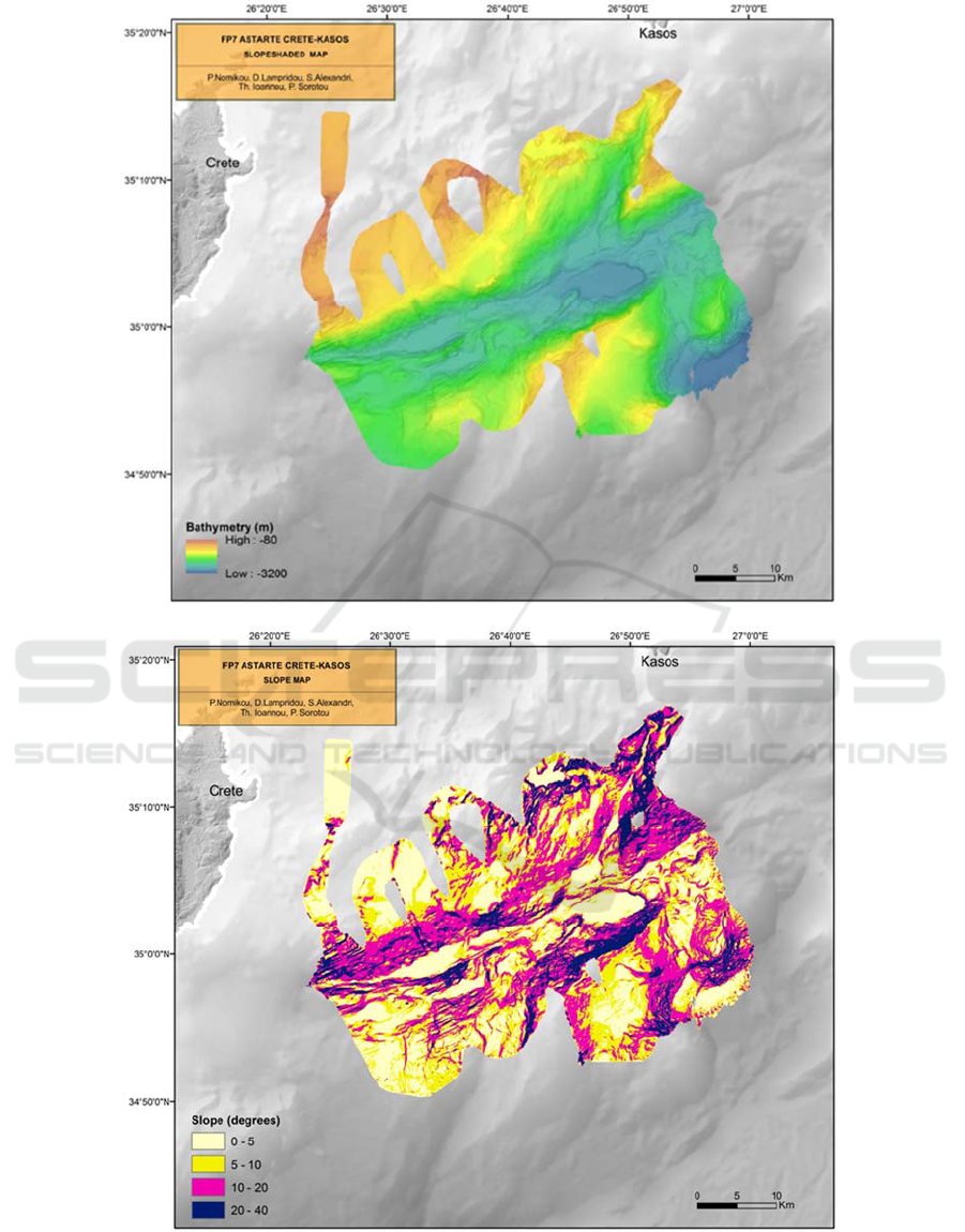
Figure 4: a) Bathymetry map, b) Slope map, c) Slope-Aspect map.
a
)
b)
GISTAM 2017 - 3rd International Conference on Geographical Information Systems Theory, Applications and Management
148
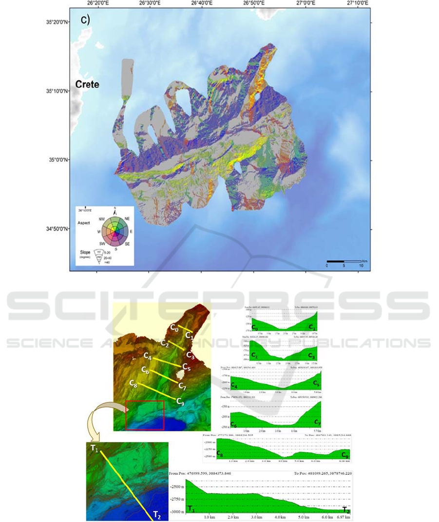
Figure 4: a) Bathymetry map, b) Slope map, c) Slope-Aspect map (cont.).
Figure 5: Detailed view of the Kasos canyon with the location of the cross sections. a. C0-C9 vertical topographic sections
perpendicular to canyon axis, b. Detailed view and topographic section (T1-T2) at the end of canyon.
Morphotectonic Analysis between Crete and Kasos
149
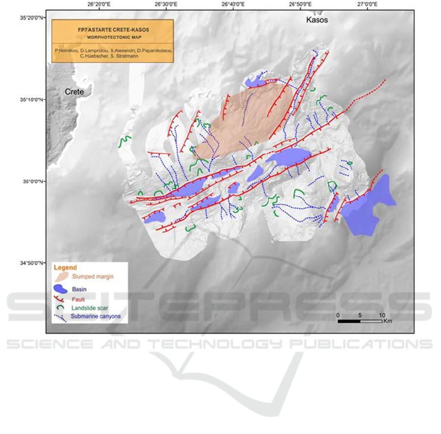
Figure 6: Morphotectonic map.
GISTAM 2017 - 3rd International Conference on Geographical Information Systems Theory, Applications and Management
150
