
Application of SensorML in the Description of the Prototype Air
Monitoring Network
Mariusz Rogulski
1
and Bogdan Dziadak
2
1
Faculty of Building Services, Hydro and Environmental Engineering, Warsaw University of Technology,
Nowowiejska 20, Warsaw, Poland
2
Faculty of Electrical Engineering, Warsaw University of Technology, Pl. Politechniki 1, Warsaw, Poland
Keywords: Interoperability, Sensor Networks, SWE, Air Monitoring.
Abstract: The aim of this publication is to present the use of OGC standards – SensorML and Observations &
Measurements – to describe the sensor network and measurement process in the prototype of air quality
monitoring network launched in Nowy Sacz in Poland. Standards are used to create structures of relational
databases to achieve interoperability through data collection in an orderly manner in the field of
environmental data and in the description of monitoring process. This is important especially when the
system consists of a number of low-cost measuring devices, that are designed to complement existing
measurement network.
1 INTRODUCTION
There are currently a lot of mobile and stationary
sensors that measure various environmental
parameters, operating independently or as part of a
number of measuring stations and monitoring
networks. Constantly also there are performed
different types of observations and measurements,
both in situ and in laboratories. All these activities
generate huge amounts of data about the state and
quality of the environment on Earth.
To fully benefit from such a huge and diverse
resources, as from global database (knowledge), it is
necessary to provide the possibility of exchanging
and sharing data between different systems, so it
requires to ensure their interoperability.
The concept of interoperability is closely linked
to information technology, especially to information
systems. Interoperability is generally referred to as
“... the ability of two or more components to
exchange information, understand it and use it...”
(Institute of Electrical and Electronics Engineers,
1990). More specifically, it may be defined as “...
the ability of various elements of functional
information systems to communicate, run programs,
or transfer data between them in a way that does not
require from the user any knowledge, or requires
from the user a minimum knowledge on the unique
properties of these elements...” (ISO/IEC 2003).
One way to ensure interoperability, is to provide
the data in a clearly defined schemes available in
specialized for this purpose network services, with
individual communication protocols. This type of
concept, regarding spatial data, is used in the Spatial
Data Infrastructures (SDI). Using SDI allows for a
certain extent to automate the use of shared metadata
and spatial data. An example of the practical
implementation of such a model is INSPIRE,
consisting of SDI of individual EU Member States.
Experiences of the implementation phase of this one
the world’s largest data harmonisation effort of
environmental information infrastructures can be
found in (Kotsev et al., 2015).
The key to ensure interoperability in the field of
environmental data are specifications developed by
OGC (Open Geospatial Consortium) and standards
developed by ISO (International Organization for
Standardization). They provide the basis for the
construction and operation of spatial information
infrastructures, while ensuring technical
interoperability, both in terms of communication of
services and data exchange.
OGC, ISO and other institutions have developed
a number of norms, standards, specifications and
recommendations for description of measuring
processes and sensors (metadata) in order to achieve
interoperability capabilities. As one of the most
important in this regard should be considered
Rogulski, M. and Dziadak, B.
Application of SensorML in the Description of the Prototype Air Monitoring Network.
DOI: 10.5220/0006379903070314
In Proceedings of the 3rd International Conference on Geographical Information Systems Theory, Applications and Management (GISTAM 2017), pages 307-314
ISBN: 978-989-758-252-3
Copyright © 2017 by SCITEPRESS – Science and Technology Publications, Lda. All rights reserved
307
SensorML. Besides it, important are, among others:
IEEE 1451, ECHONET, Device Description
Language (DDL), and Device Kit (Tang and Yeh,
2001).
The aim of this publication is to present the use
of OGC standard – SensorML – to describe the
sensors and measurement process in the prototype of
air quality monitoring network launched in Nowy
Sacz in Poland. Section 2 summarizes the IEEE
1451 standard dedicated to transmitters service
standardization, and primary elements of the
specification SensorML 2.0. Section 3 describes the
use of specifications Sensor ML to describe the
measuring process of the air quality monitoring
network based on prototype measuring stations.
Section 4 provides a summary.
2 STANDARDS OF SENSORS AND
DATA DESCRIPTION IN
MEASUREMENT SYSTEMS
Speaking about interoperability of measurement
data, we mean primarily final results of the
measuring system, which is properly formatted and
described data block, most often located in a
standardized database or data warehouse. From
there, it can be easily downloaded and processed by
other systems. However, it should be noted that the
standardization of measurement data recording can
be done from the very beginning of the measurement
process.
2.1 IEEE 1451 Standard
In order to standardize communication protocols and
use of intelligent sensors, standard IEEE 1451
(Saponara et al., 2011; Kim et al., 2011) has been
established. The origins of the work on the standard
dates back to the late twentieth century. Then the
leading manufacturers of sensors, and IEEE and
NIST, began the work associated with the
standardization of smart sensors use. The result of
this work is a family of standards under the title
IEEE 1451 Standards for a Smart Transducer
Interface for Sensor and Actuators (Dziadak et al.,
2011; Lee, 2007). In this standard, an intelligent
sensor is able to measure the acquisition, pre-process
it, format the data and send them, using an available
network, to a higher level in the measurement
system. The definition of a smart sensor is broad and
includes both sensors and actuators with a controller
chip enabling network communications or with the
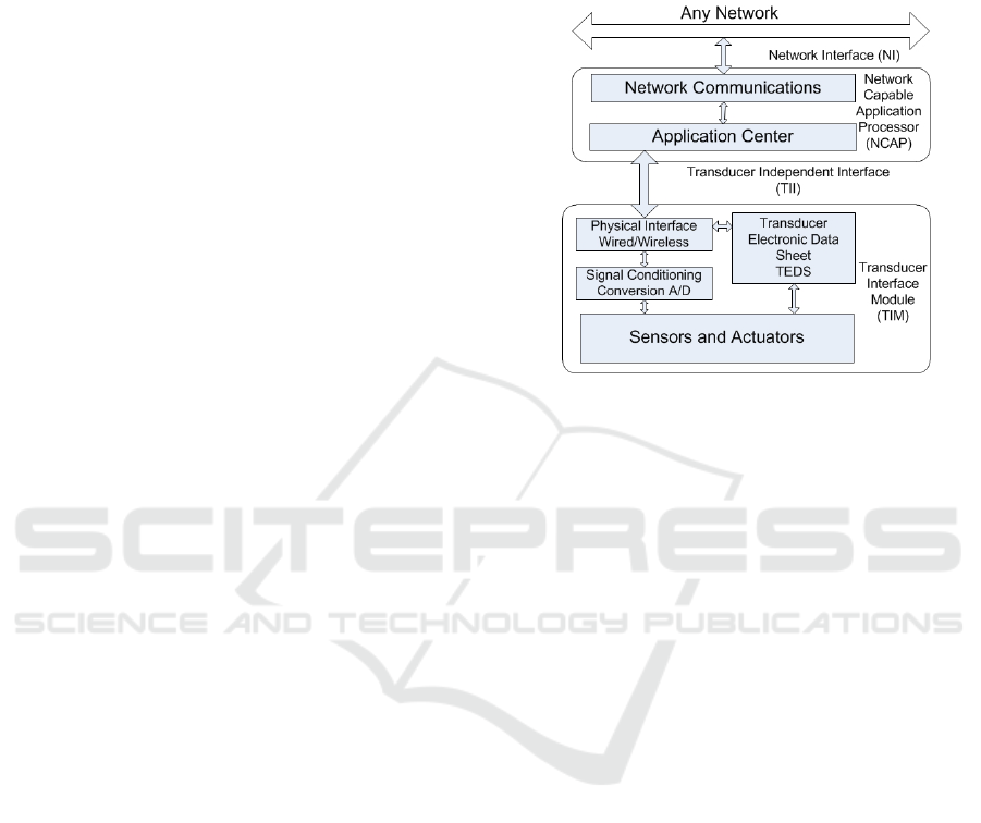
controller. Block structure of the transmitter,
compatible with the present standard, is shown in
Figure 1. We can distinguish two main blocks: -
Transducer Interface Module (TIM) and Network
Capable Application Processor (NCAP).
Figure 1: Structure of the smart transmitter in accordance
with IEEE 1451.
Transducer Interface Module consists of sensors or
actuators, conditioning and processing block A/D of
TEDES base and interface. It is responsible for
proper installation and operation of the sensor and
for the performance of measurement. Sensors should
be operated in a plug and play mode. Data for the
sensor installation in the measurement system are
downloaded from an electronic database TEDS.
Base TEDS is an electronic catalog card of the
sensor which contains all the necessary information,
such as: sensor type, measuring range, resolution,
accuracy, sensitivity, response time, and
identification data.
Network Capable Application Processor is a
block providing control of the measurement process
and communication between the block of TIM
transmitters and higher layers of the measurement
system. Most often, NCAP is a controller/computer
with the appropriate hardware and computing
capabilities allowing for translations of interfaces
and coordination of the process. NCAP can also
provide Web services and APIs dedicated to data
receivers (Higuera and Polo, 2012). Communication
with both the TIM block and the network, can be
implemented using a variety of techniques and
technologies (Pu et al., 2016). The coupling between
the IEEE 1451 standard and the standards of upper
layers of the OGC model, is shown in Figure 2.
GISTAM 2017 - 3rd International Conference on Geographical Information Systems Theory, Applications and Management
308
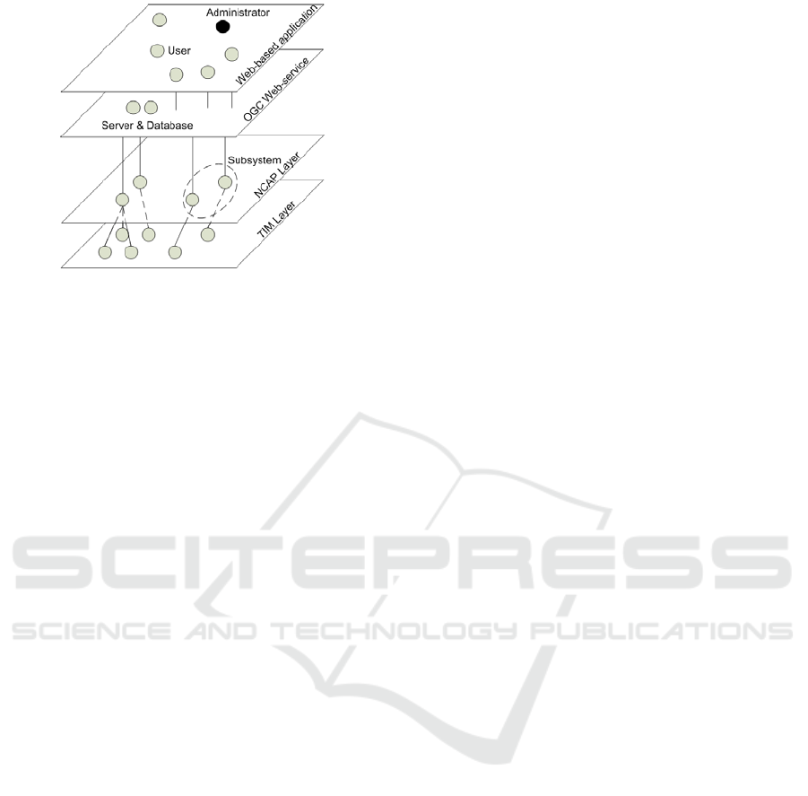
Figure 2: Structure of the smart transmitter in accordance
with IEEE1451.
The IEEE1451 standard is used to operate smart
sensors in the network for monitoring surface water
quality in the Sado Estuary Natural Reserve in
Portugal. In this network the communication
between the block of TIM transmitters and the
NCAP block is carried out with the use of RFID
(Postolache et al., 2011). Another example is air
quality monitoring system measuring NO
2
, SO
2
, CO,
O
3
, in which the authors in the controller ADuC812
realized the TIM block with a complete base of
TEDS for used sensors (Kularatna and Sudantha,
2008). In the authors' system, the standardization of
the sensor description operates at the network level,
however, the modularity of the sensor is assumed.
2.2 SensorML V2.0
SensorML v2.0 is a specification for describing
functional model of the sensors activity and
associated measurement processes. Using SensorML
can be described a wide range of sensors, including
both mobile and stationary sensors, and performing
measurements "in-situ" or remote. In addition, this
language allows for, among others: description of
algorithms needed to manage sensors, location of the
observation made by means of sensors, etc.
This language is one of the components
developed by OGC as part of the specification
Sensor Web Enablement (SWE) and the Sensor Web
initiative (Liang et al., 2005). SWE focuses on
developing specifications to cover all types of
sensors and making them accessible, usable and
controllable via the Web (Bröring et al., 2011). For
this reason, some elements (data types, classes, etc.)
are connected between the various components of
the project.
Examples of the use of SWE standard, along
with a brief description of the individual components
of this specification, can be found in (Conover et al.,
2010). In (Chen et al., 2013), the authors described
the use of SWE to create a Web directory service,
based on directory service OGC, allowing for
location, access, retrieval of parameters and use of
sensors and algorithms describing the sensors.
Technologies and standards included in the SWE
were also used to create an event-based service
receiving spatial data “on-demand” (Fan et al.,
2013). In (Kotsev et al., 2016) OGC specifications
are used in the AirSensEUR open software/hardware
multi-sensor platform for measuring ambient air
quality.
In turn, (Chen et al., 2012) using BPEL and
processes chains from SensorML, proposed a
method to create workflows for the so-called e-
science, that is those fields of science, which require
calculations in highly distributed network
environments or using huge data sets processed in
grid environments. In (Hu et al., 2014) proposed a
model of sensors description for satellite remote
sensing based on the object- and language-oriented
paradigm of SensorML. In (Jiménez et al., 2014),
the SensorML specification, with standards ISO
19156 and ISO 19115, were used to enhance the
interoperability of data in the field spectroscopy
scientific community. In (Hu et al., 2015) presented
a different perspective on geospatial data processing
and on the basis of the language of SensorML
(which is an event-driven technology) created
TaskML, which is the task-driven technology.
SensorML was also used as a framework for many
applications (Bröring, 2012), among others: EU
directive INSPIRE, EU-funded projects SANY,
South Africa AFIS project, and US OOSTethys
community Project. In (Jirka et al., 2012) is
presented a lightweight profile for the OGC Sensor
Observation Service that ensures the necessary
interoperability for environmental data provided by
the EEA’s member states. The possible applications
of SensorML in Polish SDI was proposed in
(Rogulski and Rossa, 2015).
An overview of the currently developed norms
and standards can be found in (Sánchez López,
2011). The authors discuss there, among others,
standards created by ISO (ISO/IEC 18000) or IEEE
(IEEE 1451). SensorML and O&M can also be used
in one of the newest OGC specifications – OGC
SensorThings API, created for the integration of
sensors, processes and results of observations and
measurements within the Internet of Things (IoT)
(Huang and Wu, 2016).
The basic idea of modelling using SensorML
specifications is to create measurement processes for
Application of SensorML in the Description of the Prototype Air Monitoring Network
309

which it is possible to determine the inputs, outputs,
parameters and additional information characterizing
individual steps of the process. These steps may be
other processes, measuring devices or sensors used
for measurements and observations. In its simplest
form, the measurement process may consist of a
single step. It is possible to create many different
types of processes relating to any components of the
environment. All of them are based on certain
common attributes present in the base process. The
processes can follow both the physical processes
associated with the measurements and observations,
as well as processes other than physical (e.g.
associated with a numeric processing of the
measured values or with modelling).
The core of SensorML specification is made of
the following two abstract classes, on which other
classes inherit:
DescribedObject – a class that provides basic,
common characteristics for classes of processes
(components), inherit from this class. Among
them we find a lot of descriptive characteristics
relating to general information about the process
(e.g. keywords, classifications), limitations (e.g.
validity period, access, intellectual property),
classifications (characteristics and parameters),
references (contacts and documentation), and
history. Some of them are grouped in code lists
providing the ability of easy analysis,
AbstractProcess – basic abstract class that
inherits from DescribedObject, offering
additionally attributes associated with inputs,
outputs and process parameters, indicating the
purpose of the process, as well as with the further
development of more sophisticated (e.g.
descriptively) derivatives processes.
On the basis of abstract classes following classes
are designed:
SimpleProcess – for indivisible processes, that is,
the implementation of which is treated as a
whole, consisting of one step. This class contains
additional properties that allow to describe the
methodology used in the process,
AggregateProcess – for complex, multi-step
processes, with the possibility of mapping data
flows between steps, that is determining that the
output of the step are input of the next step,
PhysicalComponent – to describe real, simple,
physical devices or sensors (processes
components), for which is important to define
spatial coordinates and time,
PhysicalSystem – used to model physical
devices, more complex than in the case of
Physical Component, as the processes for which
the location in the real world is known and
important,
Processes with Advanced Data Types – class
offering support for more advanced data types
than those offered by abstract class
AbstractProcess (e.g. DataArray, Matrix,
DataStream and Choice).
Some of the attributes belonging to the above
classes of SensorML specification, link to SWE
Common 2.0 components, as well as to the types and
structures defined in standards, in particular those
from ISO 19XXX series.
3 APPLICATION OF SENSORML
IN THE NETWORK OF AIR
QUALITY MONITORING
DEVICES
SensorML specification was used to design
structures in a relational database, where are stored
the data on the measurement network built using
prototype measuring devices in the city of Nowy
Sacz in the southern Poland. The devices were
designed by a team of researchers of the Faculty of
Electrical Engineering of Warsaw University of
Technology, and the measurement network was
established with the participation of scientists from
the Faculty of Building Services, Hydro and
Environmental Engineering of Warsaw University of
Technology. Measuring devices measure basic
meteo parameters, concentration of PM
1
, PM
2.5
,
PM
10
and CO. Prototype devices were installed in
September of 2016 and became operational in five
locations in Nowy Sacz. Installation locations
(shown in Figure 3) have been established by the
city authorities.
The purpose of the devices installation is
densification of the existing measurement network
for the area of Nowy Sacz, which consists of one
professional measurement device, owned by the
Regional Inspectorate for Environmental Protection
(RIEP). Another measuring station belonging to
RIEP is located in Szymbark near of Gorlice
(approx. 28 km in a straight line, but it does not
measure PM), and next in Tarnow (approx. 45 km in
a straight line). In the Małopolska Voivodeship, a
higher density of measuring stations occurs only in
and around Kraków, what is quite a considerable
distance from the city of Nowy Sacz. The city of
Nowy Sacz has more than 80 thousand residents,
and throughout Nowy Sacz County – approx. 200
thousand.
GISTAM 2017 - 3rd International Conference on Geographical Information Systems Theory, Applications and Management
310
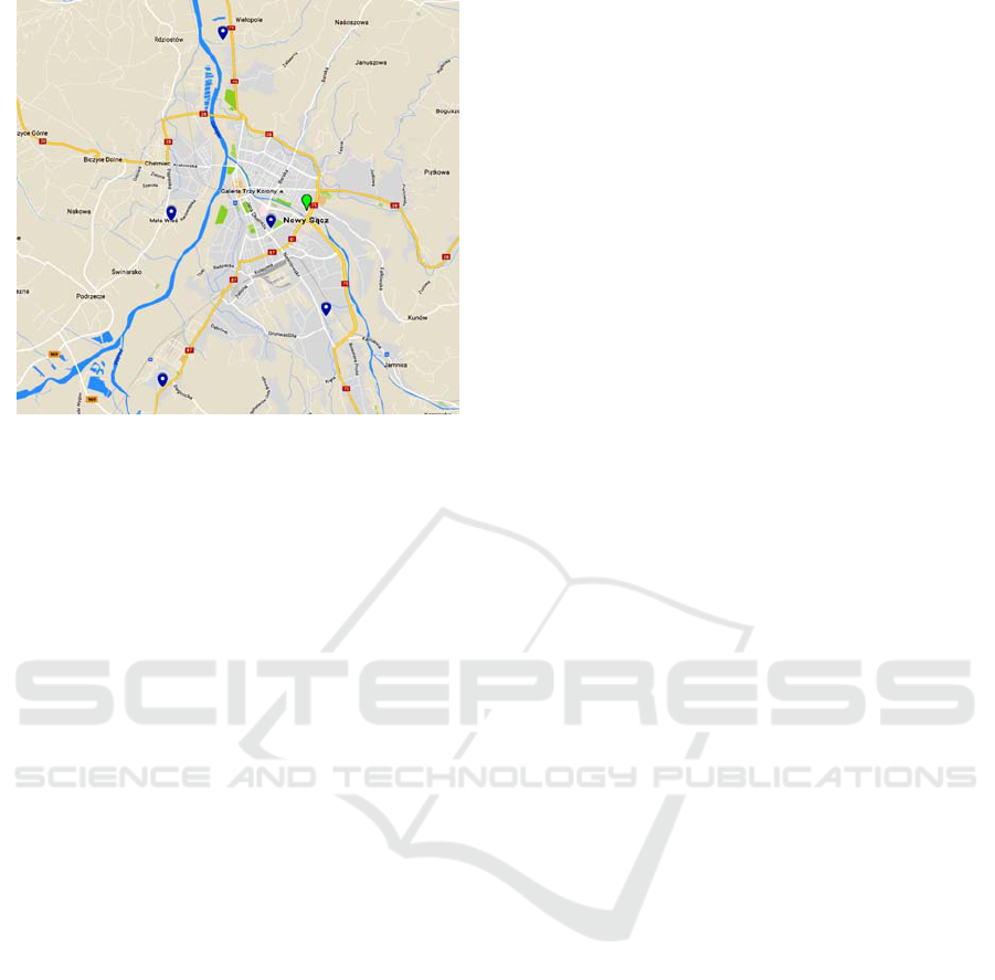
Figure 3: Locations of prototype devices. For comparison
by a different colour indicated also station of RIEP (based
on: Google Maps).
The devices operate 24 hours a day. Every minute,
they send a message to the server with the values of
measurements and basic meteo parameters. Data
transmission from the devices is done using the
built-in modems and GPRS. On the server side
works a software to collect (listening service written
in Java) and storage of data (database MySql).
Data from the various additional devices are
available to residents at: http://www.nowysacz.pl/
pomiary-powietrza, making it possible to check the
air quality in the various districts. Ultimately, based
on data obtained from measurements and on
forecasts, an air quality index will be determined.
In connection with the planned development of
measurement network throughout the region of
Nowy Sacz and with the desire to achieve
interoperability of data to describe the devices and
the measurement process, SensorML 2.0 language
has been used.
The measurement process, modelled using
SensorML, consists of the following steps:
1. Collecting data using physical sensors gathered
in the measurement stations.
2. Automatic verification of data, or verification by
the operator.
3. Determination of indicator of air quality by the
appropriate algorithm (phase in progress).
The first stage was modelled as the Physical
Component, since it is made of components whose
location in the real world is known and of
importance. At this step there is the measurement of
air parameters (pollutions) and basic meteo
parameters. This is accomplished by sensors
concentrated in the measurement stations that sense
air and provide digital numbers representing the
measures of a property of that environment.
For the other two steps, their location is not
important and they are not implemented by the
physical measuring devices, therefore they are
modelled as the Simple Process. In the second step
takes place the verification of measurements results -
automatic and by a human. In the case of, for
example, sensor failure, the measurements results
can be classified as erroneous and do not take them
to the air quality assessment in the third step.
In the third step, on the basis of measurements of
pollution, meteorological data and forecasts, will be
determined air quality index, as the most affordable
for the residents. An appropriate algorithm will play
here a main role.
All three steps of data acquisition and processing
are combined in a multi-step measurement process
using class AggregateProcess.
For the first step, the most important parameters
involved in the process described herein are
following:
Process type: Physical Component,
Inputs: temperature, humidity, pollutions,
Outputs: weather (temperature, humidity),
pollutions (PM
1
, PM
2.5
, PM
10
),
System Location: locations of measuring points
(as shown in Figure 3),
System Components: Temperature sensor,
Humidity sensor, Pollution sensor.
For the second step, the most important
parameters involved in the process described herein
are following:
Process type: Simple Process,
Inputs: weather (temperature, humidity),
pollutions (PM
1
, PM
2.5
, PM
10
),
Outputs: weather (verified temperature and
humidity values), pollution (verified PM
1
, PM
2.5
and PM
10
values),
System Components: verification of pollutants,
verification of meteo parameters.
For the third step, the most important parameters
are as follows:
Process type: Simple Process,
Inputs: weather (verified temperature and
humidity values), pollutions (verified PM
1
, PM
2.5
and PM
10
values),
Outputs: air quality index,
System Components: determination of air quality
index.
To enable the collection and storage of data on
sensors and measurement system, according to the
SensorML specification, application diagram was
brought to a relational database schema. The
Application of SensorML in the Description of the Prototype Air Monitoring Network
311
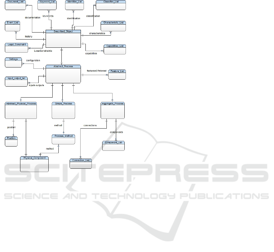
conceptual diagram of the most important entities is
shown in Figure 4.
Figure 4: ERD diagram based on SensorML.
Described_Object is a basic entity in the model,
corresponding to the class of DescribedObject from
SensorML. Complex class attributes, attributes that
are different data types, or cardinality more than 1,
are modelled as separate entities:
Keyword_List – keywords describing sensors
and various stages of the measuring process,
Identifier_List – a list of generic identifiers
describing sensors (names of sensors,
manufacturers, models, serial numbers) and the
successive stages of data processing,
Classifier_List – list of classifiers describing
sensors (e.g. dust sensor, sensor measuring
temperature, humidity), and the various stages of
the measurement process (manual correction of
the measurement results by the operator,
automatic determination of the air quality index),
Legal_Constraint – information about intellectual
property of used tools and algorithms – based on
ISO 19115 (intellectual property of measuring
station design, its software and algorithms used
in the subsequent phases belongs to the scientists
from the Warsaw University of Technology),
Characteristic_List – a detailed description of
used sensors and measuring stations (including
dimensions, connection method of individual
components) and the parameters of the
algorithms used in the subsequent stages of the
process,
Event_List – a history of changes to the system
parameters (e.g. information of sensors
replacements, repairs of measuring stations,
configuration changes, etc.),
Document_List – documentation of sensors
(from external suppliers), measuring station and
software used for the collection and transmission
of data, and documentation of developed
software tools used in the subsequent stages of
data processing.
Abstract_Process is an entity related to the class
AbstractProcess. Complex class attributes or
attributes, which are other types of data, were
modelled as separate entities:
Settings – information about the current settings
of individual components,
Feature_List – a list of objects for sensors
observation (e.g. atmosphere surrounding an air
monitoring station – in the case of sensors, air
quality in Nowy Sacz – in the case of
algorithms),
Input_Output_List – entity corresponding to the
attributes of 'inputs' and 'outputs' – contains a list
of inputs and outputs of specific steps.
Aggregate_Process is an entity related to the
class AggregateProcess, it ties all measurement
process steps. It includes:
Connection_List – connections between outputs
and inputs of individual steps,
Component_List – connections between the
elementary steps that make up the aggregate
process.
Abstract_Physical_Process is an entity related to
the class AbstractPhysicalProcess. It includes:
Position – information about the location of
individual sensors and the time of which they
were installed in a given location.
Physical_Component is an entity related to the
class PhysicalComponent. It includes:
Process_Method – a description of the
methodology of the measurement or processing
by algorithms.
Complete list of attributes in the individual
entities have resulted primarily from a list of
attributes (properties) of each class of specifications
of SensorML 2.0, SWE Common 2.0 and ISO 19115
standard. In addition, the model includes columns
relating to the physical implementation of the
relational schema in the database.
In order to record measurement results and bind
GISTAM 2017 - 3rd International Conference on Geographical Information Systems Theory, Applications and Management
312
them to the respective steps of the measurement
process, an another standard of OGC has been
applied – Observations & Measurements (O&M). A
simplified conceptual diagram, designed to record
the results of measurements, is shown in Figure 5.
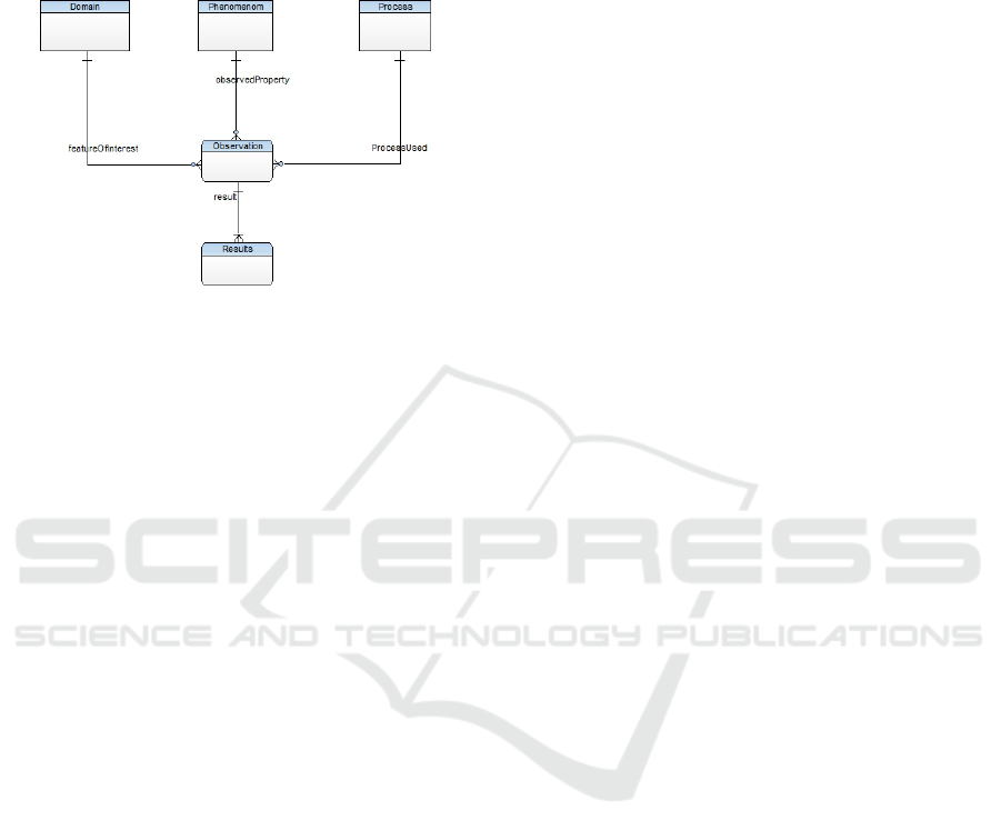
Figure 5: ERD diagram based on O&M.
Also in this case, individual entities and their
attributes essentially correspond to the classes and
attributes from the specifications O&M. The
relational model includes, among others, following
entities:
Domain – contains a list of objects from the real
world (featureOfInterest) which are investigated
by means of measurements (the list includes
values: atmosphere, air),
Phenomenon – contains a list of object properties
(observedProperty) which are investigated by
means of measurements (the list contains
humidity, temperature, pollution, dust),
Results – contains a list of measured values,
Process – contains a link to the measurement
process described by SensorML,
Observation – contains general data on the
elemental measurement which includes measured
values, among others, of various types of dust
and meteorological parameters.
4 CONCLUSIONS
Standards and specifications used to create
structures of relational databases are used to achieve
interoperability through data collection in an orderly
manner. Application of the standard SensorML and
guidelines from other standards of ISO and OGC, is
enabled by standardized description of the
measurement process. This is important when the
system consists of a number of measuring stations
and sensors. Building new, low-cost measuring
devices, that are designed to complement existing
measurement network, it was necessary to select
how to describe of devices, process, as well as
acquired data. In this context, the use of OGC
standards was quite natural, especially in the context
of the recently published OGC specification -
SensorThings API. Although, the currently operating
devices in Nowy Sacz are not directly available to
other users (and only the results of these
measurements), the use of OGC standards does not
close the possibility to this was available in the
future.
In the case of this system, there is a plan for
further development by adding more measuring
stations and sensors that measure other substances. It
is also possible to move existing measuring stations
to new places, so the above scheme will allow for
the storage of structured and standardized system
information. As a result, it is possible to build a
system whose elements will be fully interoperable.
In the future, it is planned to expand the system
by, among others, adding a set of interactive
webservices (with interoperable interfaces like the
OGC Sensor Observation Service – SOS), which can
be easily integrated with existing SDI and
geographical information systems. This will make
possible to easily create extracts of data describing
system and combine them with data from other
sources, by which a full interoperability of the
system will be achieved.
REFERENCES
Bröring, A., 2012. Automated On-the-fly Integration of
Geosensors with the Sensor Web. Ph.D. Dissertation,
University of Twente, Enschede, The Netherlands.
Bröring, A.; Echterhoff, J.; Jirka, S.; Simonis, I., Everding,
T., Stasch, C., Liang, S.; Lemmens, R., 2011. New
generation sensor web enablement. Sensors, vol. 11,
pp. 2652–2699.
Chen, N., Hu, C., Chen, Y., Wang, C., Gong, J., 2012.
Using SensorML to construct a geoprocessing e-
Science workflow model under a sensor web
environment. Computers & Geosciences, vol. 47, pp.
119–129, doi: 10.1016/j.cageo.2011.11.027.
Chen, N., Wang, X., Yang, X., 2013. A direct registry
service method for sensors and algorithms based on
the process model. Computers & Geosciences, vol. 56,
pp. 45–55, http://dx.doi.org/10.1016/
j.cageo.2013.03.008.
Conover, H., Berthiau, G., Botts, M., Goodman, H.M., Li,
X., Lu, Y., Maskey, M., Regner, K., Zavodsky, B.,
2010. Using sensor web protocols for environmental
data acquisition and management, Ecological
Informatics, vol. 5, pp. 32–41, doi: 10.1016/
j.ecoinf.2009.08.009.
Dziadak, B., Makowski, L., Michalski, A., 2011.
Embedding wireless water monitoring system in
Application of SensorML in the Description of the Prototype Air Monitoring Network
313

Internet. Przegląd Elektrotechniczny, vol. 4, pp. 246–
248.
Fan, M., Fan, H., Chen, N., Chen, Z., 2013. Active on-
demand service method based on event-driven
architecture for geospatial data retrieval. Computers &
Geosciences, vol. 56, pp. 1–11.
Higuera, J., Polo, J., 2012. Autonomous and Interoperable
Smart Sensors for Environmental Monitoring
Applications, in: Mukhopadhyay, S.C. (Ed.), Smart
Sensing Technology for Agriculture and
Environmental Monitoring, Lecture Notes in
Electrical Engineering. Springer Berlin Heidelberg,
pp. 323–359, doi:10.1007/978-3-642-27638-5_16.
Hu, Ch., Li, J., Chen, N., Guan, Q. 2014. An Object
Model for Integrating Diverse Remote Sensing
Satellite Sensors: A Case Study of Union Operation.
Remote Sensing, vol. 6, pp. 677–699, doi:
10.3390/rs6010677.
Hu, L., Yue, P., Zhang, M., Gong, J., Jiang, L., Zhang, X.,
2015. Task-oriented Sensor Web data processing for
environmental monitoring. Earth Science Informatics,
vol. 8, pp. 511–525, doi: 10.1007/s12145-015-0235-1.
Huang, Ch., Wu, Ch., 2016. A Web Service Protocol
Realizing Interoperable Internet of Things Tasking
Capability. Sensors, vol. 16, doi: 10.3390/s16091395
(sensors-16-01395).
IEEE Standard, Institute of Electrical and Electronics
Engineers. IEEE Standard Computer Dictionary: A
Compilation of IEEE Standard Computer Glossaries.
p. 42, New York, 1990.
ISO/IEC, Technical Draft Report, Ref. No. JTC1 SC36
WG4 N0070. Information Technology – Learning,
education, and training – Management and delivery –
Specification and use extensions and profiles, 2003.
US SC36 Secretariat.
Jiménez, M., González, M., Amaro, A., Fernández-Renau,
A., 2014. Field Spectroscopy Metadata System Based
on ISO and OGC Standards. International Journal of
Geo-Information, vol. 3, pp. 1003–1022, doi:
10.3390/ijgi3031003.
Jirka, S., Bröring, A., Kjeld, P., Maidens, J., Wytzisk, A.,
2012. A Lightweight Approach for the Sensor
Observation Service to Share Environmental Data
across Europe. Transactions in GIS, vol. 16: pp. 293–
312, doi: 10.1111/j.1467-9671.2012.01324.x.
Kim, J.-D., Kim, J.-J., Park, S.-D., Hong, C.-H., Byun, H.-
G., Lee, S.-G., 2011. A Smart Web-Sensor Based on
IEEE 1451 and Web-Service Using a Gas Sensor, in:
Computers,Networks, Systems, and Industrial
Engineering. Springer, Berlin, Heidelberg, pp. 219–
235, doi: 10.1007/978-3-642-21375-5_19.
Kotsev, A., Peeters, O., Smits, P., Grothe, M., 2015.
Building bridges: experiences and lessons learned
from the implementation of INSPIRE an e-reporting of
air quality data in Europe. Earth Science Informatics.
vol. 8, pp. 353–365, doi: 10.1007/s12145-014-0160-8.
Kotsev, A., Schade, S., Craglia, M., Gerboles, M., Spinelle
L., Signorini, M., 2016. Enriching Authoritative
Environmental Observations: Findings from
AirSensEUR. GSW 2016 - Geospatial Sensor Webs
Conference, Münster, Germany.
Kularatna, N., Sudantha, B.H., 2008. An Environmental
Air Pollution Monitoring System Based on the IEEE
1451 Standard for Low Cost Requirements. IEEE
Sensors Journal, vol. 8, pp. 415–422,
doi:10.1109/JSEN.2008.917477.
Lee, K., 2007. Sensor standards harmonization-path to
achieving sensor interoperability, in: IEEE
Autotestcon. IEEE, pp. 381–388.
Liang, S., Croitoru, A., Tao, C., 2005. A distributed
geospatial infrastructure for Sensor Web. Computers
& Geosciences, vol. 31, pp. 221–231, doi:
10.1016/j.cageo.2004.06.014.
Postolache, O., Girão, P.S., Pereira, J.M.D., 2011. Water
Quality Assessment through Smart Sensing and
Computational Intelligence, in: Mukhopadhyay, S.C.,
Lay-Ekuakille, A., Fuchs, A. (Eds.), New
Developments and Applications in Sensing
Technology, Lecture Notes in Electrical Engineering.
Springer Berlin Heidelberg, pp. 191–206, doi:
10.1007/978-3-642-17943-3_10.
Pu, F., Wang, Z., Du, C., Zhang, W., Chen, N., 2016.
Semantic integration of wireless sensor networks into
open geospatial consortium sensor observation service
to access and share environmental monitoring systems.
IET Software, vol. 10, pp. 45–53, doi: 10.1049/iet-
sen.2014.0141.
Rogulski, M., Rossa, M., 2015. The applicability of SWE
in Polish spatial data infrastructures - the example of
the SensorML language. Foundations of Computing
and Decision Sciences, vol. 40, pp. 187–201, doi:
10.1515/fcds-2015-0012.
Sánchez López, T., 2011. RFID and sensor integration
standards: State and future prospects. Computer
Standards & Interfaces, vol. 33, pp. 207–213, doi:
10.1016/j.csi.2010.09.002.
Saponara, S., Fanucci, L., Neri, B., 2011. IEEE 1451
Sensor Interfacing and Data Fusion in Embedded
Systems, in: Conti, M., Orcioni, S., Madrid, N.M.,
Seepold, R.E.D. (Eds.), Solutions on Embedded
Systems, Lecture Notes in Electrical Engineering.
Springer Netherlands, pp. 59–73, doi: 10.1007/978-94-
007-0638-5_5.
Tang, S.-M., Yeh, F.-L., Wang, Y.-L., 2001. An efficient
algorithm for solving the homogeneous set sandwich
problem. Information Processing Letters, vol. 77, pp.
17–22.
GISTAM 2017 - 3rd International Conference on Geographical Information Systems Theory, Applications and Management
314
