
Pervasive Ambient Intelligence Platforms in the IOT Era based
on a Ubiquitous User Model Ontology
An Implementation Account
Alfio Costanzo, Alberto Faro and Daniela Giordano
Department of Electrical, Electronics and Computer Engineering
University of Catania, viale A.Doria 6, 95125, Catania, Italy
Keywords: Pervasive Information Systems, Ambient Intelligence, Ubiquitous User Model Ontology, Smart Cities.
Abstract: This paper presents how ambient data integration is obtained in Wi-City, i.e. a project promoted by the
Regional Government of Sicily that aims at supporting mobile people activities by means of intelligent
applications able to generate personalized recommendations that take into account both personal and context
parameters. The paper shows how this is made possible by the decreasing cost of the monitoring systems in
the IOT era and by the availability of ontology engineering methods to data integration. In particular, aim
of the paper is to illustrate a pervasive platform consisting of environmental sensors readily installable on
the city and body sensors easily wearable by people that cooperate by means of an ambient data ontology to
better support the user decisions in a smart city. Examples of how embedded consumer electronics products
are used to monitor the user ambient and how developing an effective ambient data ontology are illustrated
to give an implementation account of the proposed platform.
1 INTRODUCTION
In a smart city, the citizens are able to use the
technologies that improve the relevant aspects of
their life (Aoun, 2013). A step beyond the smart city
is the intelligent city scenario where an open and
interoperable city information platform is able to
support ubiquitous decision making by using
intelligent systems (Berthon, 2011). In this scenario
ambient information plays an important role. Indeed,
at the basis of an effective decision support system
there is the information coming from devices able to
recognize the people activities, to measure the
parameters of the systems in which the people
carries out its activities, including traffic and
environment, and to monitor the health conditions.
Today, the various city life aspects are mainly
managed by separate decision support systems and
consequently the ambient intelligence is partitioned
into sub-ambients that don't communicate between
them, e.g., car navigators help drivers only to find
the best path to the desired destination, whereas
specific e-health applications send alarms to rescue
the users involved in accidents.
However, the increasing diffusion of mobile
devices makes possible, in principle, to inform the
users about the most suitable actions using the same
terminal device independently on if they are at
home, at office or are walking or driving.
Also, the more and more decreasing cost of the
monitoring systems in the era of IOT (Internet Of
Things) makes possible to support the user activities
by means of intelligent applications able to generate
recommendations that take into account both
personal and context parameters. Indeed, these
ambient data may be monitored by means of
embedded consumer electronics products provided
with network identifiers and cooperating between
them under the supervision of an Ambient
Intelligence (AmI) software resident on the user
mobile and/or in some remote city server.
For example fig.1 shows the pervasive e-health
service envisaged in (Acampora, 2013) for an
ubiquitous rescue of people. It is based on the
interconnection of different AmI technologies
involving body sensors, emergency response and
hospital equipments.
Although such picture has the merit of
envisaging the interconnection of the data collected
by different AmI technologies to give rise to a
ubiquitous system at urban scale, it underestimates
the critical problems to be solved for the real
72
Costanzo A., Faro A. and Giordano D..
Pervasive Ambient Intelligence Platforms in the IOT Era based on a Ubiquitous User Model Ontology - An Implementation Account.
DOI: 10.5220/0004812900720078
In Proceedings of the 4th International Conference on Pervasive and Embedded Computing and Communication Systems (PECCS-2014), pages 72-78
ISBN: 978-989-758-000-0
Copyright
c
2014 SCITEPRESS (Science and Technology Publications, Lda.)
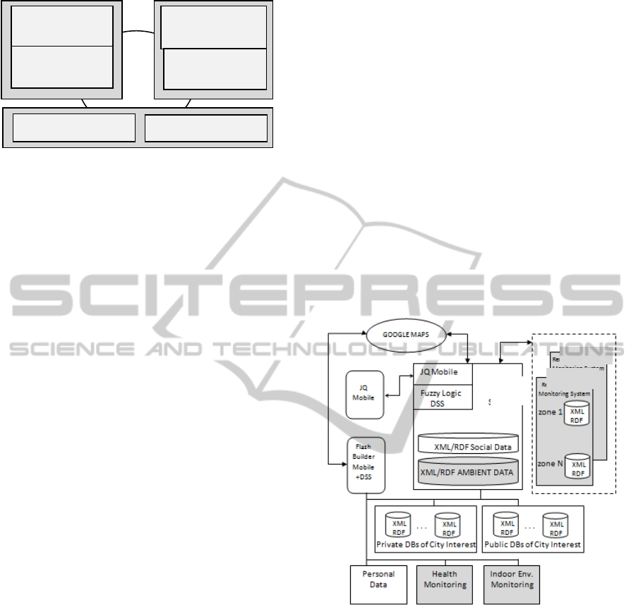
Figure 1: A general perspective of a pervasive e-Health
system hiding critical implementation issues.
interoperability of the data collected by the different
consumer electronics devices.
An ubiquitous architecture able to manage all the
mentioned information sub-systems has been
proposed by the authors in previous papers where all
the mentioned data are integrated by an ontology
based approach and a fuzzy logic based engine is
adopted to support the decisions of the users and of
the rescuers, e.g., (Costanzo, 2013a).
The original aim of Wi-City was to support
mobility and logistics activities of citizens. Then, the
monitoring system was mainly dedicated to collect
traffic data by in situ technologies, e.g., (Leduc,
2008), (Faro, 2008), (Faro, 2011a). Such data are
sent to the main city server where they are stored in
XML/RDF format (http://www.w3.org/RDF). Also,
personal data giving a general description of the
current user status and task are stored on the user
mobile so that the Decision Support System (DSS)
implemented on the server or in the user's mobile
may be able to suggest the best path to destination or
the best delivery cycle taking into account the traffic
conditions and the general user status. Data of city
interest stored on public or private databases may be
used by the DSS to identify the service most suitable
for the mobile-device-using users.
Aim of the paper is to improve this architecture
by taking into account the local and global ambient
data collected by an ubiquitous monitoring platform
consisting of cooperating sensors readily installable
on the city and easily wearable by people to better
support the user decisions.
In particular, in sect.2 we show how the
functional Wi-City architecture has been extended to
include the ambient monitoring functions. In
addition, the consumer electronics products and
their interconnection to implement the above Wi-
City extension are briefly illustrated. Sect.3
discusses the data ontology for ambient data
integration at city level taking into account the
General User Model Ontology (Heckmann et al.,
2005) and its extension (Costanzo, 2013b).
2 AMBIENT DATA IN WI-CITY
Fig.2 shows how the Wi-City architecture has been
extended to take into account the ambient data. In
particular, suitable applications have been developed
to measure the indoor environment parameters and
the physiological variables so that the DSS resident
on the mobile provided with Flash Builder based
software version (Corlan, 2009) may take into
account the user's health status and regulate the
indoor environment, e.g., (Costanzo, 2014). The
main weather parameters are collected by a
distributed monitoring system supervised by the Wi-
City server to inform the user about critical weather
conditions that influence the outdoor activities.
Figure 2: Wi-City architecture including ambient data
Fig.3 shows the implementation structure adopted in
Wi-City to monitor the main parameters of the
outdoor environment. The interested reader may find
the ones dealing with e-health and indoor monitoring
in (Costanzo, 2014).
The internal structure of this station allows us to
point out that, apart the mechanical devices devoted
to measure the rain quantity and wind
intensity/direction that have dimensions of about ten
centimetres (see fig.4a), the other devices measuring
pressure, temperature, humidity and gas emission,
may be embedded into a system of very limited
dimensions, as shown in fig. 4b.
People at
Smart Home
Mobile Body
Sensors
Smart Hospital
Smart
Transportation
Medical Personnel
Emergency
Services
TRAFFIC
MONITORING
WEATHER
MONITORING
WI-CITY
SERVER
PervasiveAmbientIntelligencePlatformsintheIOTErabasedonaUbiquitousUserModelOntology-AnImplementation
Account
73
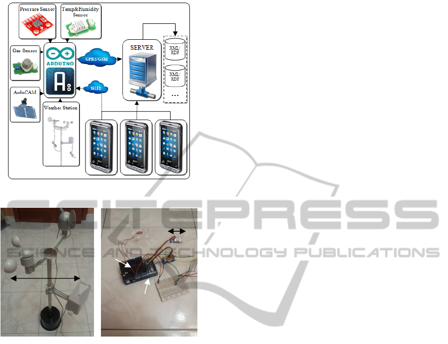
Figure 3: Wi-City environment monitoring station.
Figure 4: Environment monitoring station: apparatus to
measure rain quantity and wind direction/intensity on the
left, and Arduino controller on the right.
To transform the sensors of such station into things
of internet, they have been supervised by an Arduino
board (Banzi, 2009). Fig.5b shows how this board
collects all the data coming from the environment
sensors and sends them, through a GPRS/GSM
shield, to the main Wi-City server where they are
available to the users. This station has been provided
with a Arducam to make available on internet a
picture of the zone involved in bad weather or
congested traffic conditions.
The users' mobiles may access directly the data
stored on the stations so that the DSS resident on the
mobiles may obtain very fast the ambient data
without overloading the main server. In other words,
the modularity of the system allows the user's
mobiles to work cooperatively with the monitoring
stations without the server intervention, thus
increasing the time performance of the system.
The chosen implementation architecture is fault
tolerant since the system functions show a graceful
degradation in case of a failure of a component.
Also, it guarantees high reliability and accuracy at
low cost since cheaper electronics components able
to work with a satisfactory continuity and precision
are widely available on the market.
On the contrary, for what concerns the
interoperability, although the data collected by the
Arduino controllers are sent in JSON format
(http://www.json.org) that can be easily converted
into XML/RDF statements, this does not guarantee
per se the data interoperability.
Indeed, to this aim, it is required that not only
every measured data is stored by a triple (subject,
predicate, object), e.g.: (device_id_01, temperature,
25°), but also that the terminology used, i.e., the
predicate temperature and related properties, should
be known by both the Arduino controllers and the
DSSs so that they may work cooperatively. A
suitable ambient data ontology is sketched in sect.3.
3 AMBIENT DATA ONTOLOGY
Currently, there is no data ontology proposed by the
standardization organization, e.g. the World Wide
Web Consortium (W3C), to represent the data
featuring all the aspects relevant for the citizen
activities, e.g., health, environment and preferences.
However, this should not prevent the use of the
ontological approach to data integration. Indeed, one
may develop a suitable ontology to manage the
relevant aspects that a DSS should consider to issue
its recommendations to support mobile people in a
smart city and publish this ontology using a suitable
editor, e.g., Protégé (http://protege. stanford.edu) so
that it may be used by any remote processes to
extract the XML/RDF data stored in the mobiles or
in the main server using JSON queries.
Also, this solution allows the remote DSSs to
issue SPARQL queries (http://www.w3.org/TR/ rdf-
sparql-query) if the data are formatted by means of
the Ontology Web Language (OWL) defined in
(http://www.w3.org/2004/OWL).
A suitable ontology mapping should be done
when the standard ontology will be available; but, to
avoid of organizing the data relevant for user's
activity modelling by means of a folk ontology that
will require a great mapping effort when the
standard ontology will be available, in our
implementation we structured these data taking into
account the extended General User Model Ontology
(GUMO) outlined in fig.5, that is a meaningful step
towards a standard user model ontology.
Let us note that the ontology of fig.5 differs from
GUMO since it contains further data sections, e.g.,
10 cm
1 cm
Arduino
Controller
GPRS-
GSM
Shield
PECCS2014-InternationalConferenceonPervasiveandEmbeddedComputingandCommunicationSystems
74
the ones related to the car traffic and to the services
of city interest. Also, the terminology to represent
the data within each section takes into account the
one proposed by GUMO, as well as the terminology
proposed by a companion GUMO ontology called
UbisWorld (Heckmann, 2006). A reconciliation of
terms and properties should be done in future
works.
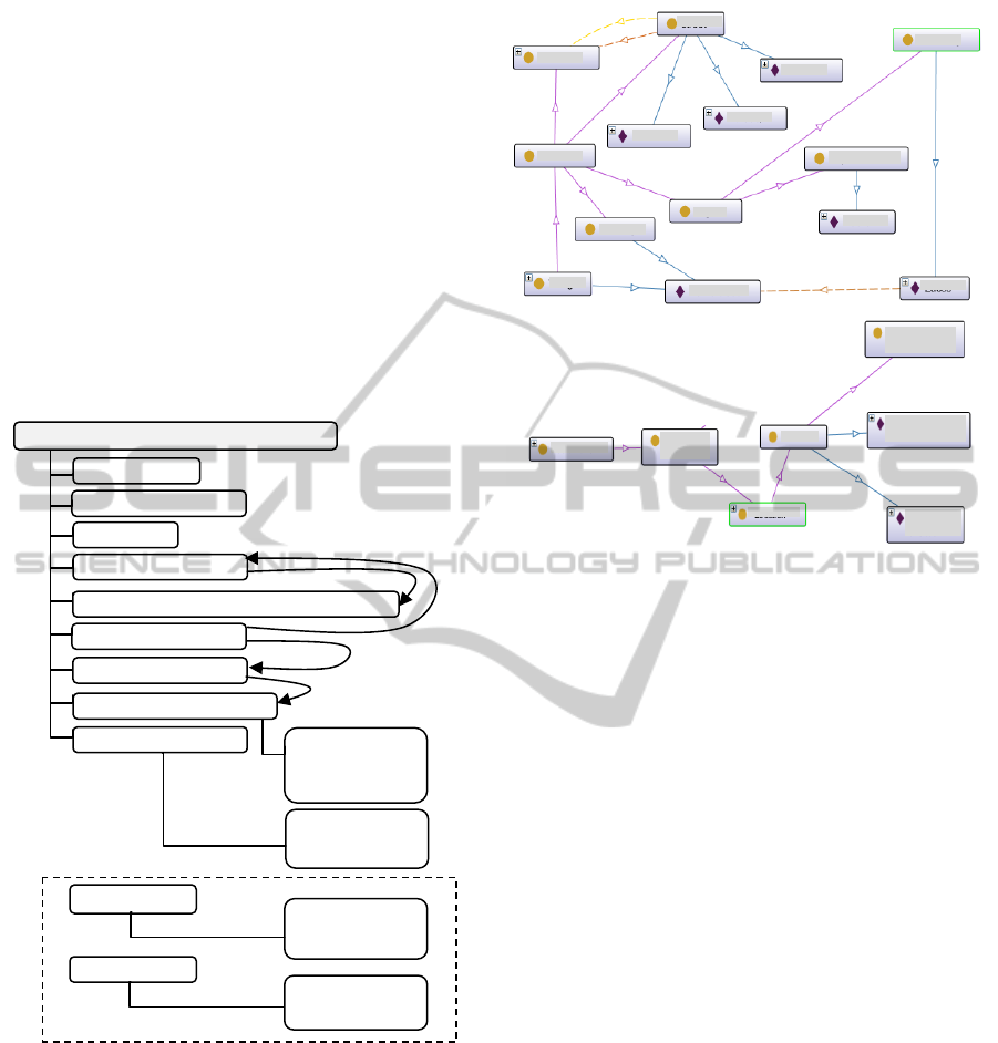
Since the paper deals with ambient data, in fig. 6
we point out how they are represented in Wi-City
and some differences with UbisWorld. To this aim,
on the top of fig.6 we sketch, by means of the
OntoGraph option of Protégé, the part of the Wi-
City ontology representing transport facilities and
urban services. Circles and rhombi denote
respectively classes and individual objects.
Figure 5: Extending the GUMO structure
Let us note that any ontology may be represented by
an object oriented (OO) language, but that an OO
program is not necessarily developed according to a
standard data ontology since object names and
properties may be chosen freely by the programmer.
Also, data ontology refers to the standard
terminology to be used in a certain knowledge
domain and may be more conveniently represented
by markup languages such as XML, RDF or OWL.
Therefore, differences between ontology
representations deal with the terms used and their
Figure 6: Some transport concepts used in Wi-City (on the
top) versus UbisWorld (on the bottom).
interrelations. Fig. 6 points out that in Wi-City the
name of a street (service) is an individual object
rather than one of the data fields of a street (service)
as suggested by UbisWorld (see the bottom of
fig.6). Also, in Wi-City the urban graph is defined as
a set of street traits delimited by crossroads,
whereas this aspect is not handled by UbisWorld.
The physiological conditions are well
represented in GUMO by the data collected by the
Biometrical Sensors, as pointed out in fig.5, e.g.,
EOG, EOM, and ACC sensors. But, in GUMO it is
not present a section dealing with the Environmental
Sensors, although such sensors should be foreseen
explicitly in the ontology to represent the things of
internet used to measure the indoor and outdoor
environment conditions.
Indeed, in GUMO the environment data are
described generically by variables referred to either
indoor or outdoor locations and collected under the
section Physical environment in fig.5.
Moreover, both in GUMO and UbisWorld the
properties of the ambient ontological entities, i.e.,
the ones linking the main subjects to the objects of
the ambient domain, are not defined explicitly.
Therefore, how linking the subjects to relevant
ambient objects by agreed properties (also named
predicates) is still an open problem.
A simple way to solve this problem is the one of
linking any subject of our domain, e.g., a person or a
car, to the location by the predicate IsLocatedIn and
Stores
EtneaDQ
EtneaQV
EtneaDS
Pharmacy
Supermarket
Crossroad
Street
Resource
BusStop
Zacco
Auchan
Barriera
Thing
UbisWorld
Street
Segments
Street
Location
S
p
atial
Elements
Etnea
Street
Europe
square
Personal
Demo
g
ra
p
hic
Abilities
Ph
y
siolo
gy
BioSensors
(
e.
g
.
,
ECG
,
EOG
,
EOM
,
ACC
)
Current State
Location
User Preferences
Physical Environmen
t
has physiological data
is measured by
is located in
is featured by
Temperature
Pressure
Humidity
Luminosity
Preferred Media
Contents, Job,
Hobby, Holiday
Traffic Network
Car flows, Travelling
times, Road accidents,
Road works, ...
Cit
y
Services
Hospitals, Parks,
Pharms, Fuel Stations,
Public Offices, ...
General User Model Ontology (GUMO)
PervasiveAmbientIntelligencePlatformsintheIOTErabasedonaUbiquitousUserModelOntology-AnImplementation
Account
75
the location to the environment by predicates such as
ItsTemperatureIs or ItsHumidityIs. The values of a
variable should not be represented as individual
objects unless such values refer to a stable entity,
e.g., the name of a street may be seen as an
individual object whose temperature is given by a
data measured by a thermometer and the current
temperature value is a field of such data.
Following such conceptualization, the main
environmental data featuring the location of the
person named "Annalisa" may be represented by the
simple ontology shown in fig. 7 that should be read
as follows: Annalisa (subject/individual object) is
located in (predicate) Etnea Street (subject/
individual object) where there is the thermometer
T01 (subject/ individual object). The street
temperature is the data measured by T01, whose
current value is the current street temperature.
Analogously, the user heartbeats are not an
individual object but are data associated to the ECG
sensor worn by the user. This is represented in the
ontology of fig.8 where we take into account both
physiological and environmental ambient data.
Such ontology may be described as follows:
Annalisa is located in the Etnea Street and wears an
ECG, i.e., one of the wearable biometrical sensors.
In the street there is a temperature sensor that is one
of the sensors of a weather station. Her heartbeats
and the street temperature are given by the values
associated to the data heartbeats and temperature of
the ECG identified by ECG01 and by the
thermometer identified by T01.
Figure 7: Ontology describing some environment data
Figure 8: Ontology describing some ambient data at
different abstraction levels.
Although we have discussed only some aspects of
how building a suitable ambient ontology, it is easy
to understand that defining a well structured
ontology is a complex task, but once the ontology is
defined, it is simple to insert novel instances, such as
further monitoring devices, as soon as they are
installed in the system. For example, a novel ECG,
i.e., the one named ECG02 worn by John whose
current heartbeats are 75 bpm, may be represented
by inserting into the OWL file of the outlined
ontology the following few statements:
<ClassAssertion>
<Class IRI="ECG_-_Electrocardiogram_Sensor"/>
<NamedIndividual IRI="ECG02"/>
</ClassAssertion>
<ObjectPropertyAssertion>
<ObjectProperty IRI="IsWornBy"/>
<NamedIndividual IRI="ECG02"/>
<NamedIndividual IRI="#John.200100"/>
</ObjectPropertyAssertion>
<DataPropertyAssertion>
<DataProperty IRI="heartbeaths"/>
<NamedIndividual IRI="ECG02"/>
<Literal datatypeIRI="http://www.w3.org/2001/
XMLSchema#float">75.0</Literal>
</DataPropertyAssertion>
Let us note that the last assertion deals with the ECG
measurement at a certain moment in time, and
therefore it should be stored into a data base with
date and day time information. In fact, at the
reception of an update ECG measurement the older
values are substituted by the new ones and are no
longer available on line.
The management of the data collected by the
environment sensors may be carried out analogously
as shown by the interface implemented at the Wi-
City server (fig.9): the current data coming from the
weather stations are on line, the older ones are
archived and may be analyzed by choosing the
option "archived data".
Figure 9: Wi-City Monitoring system to check the wheater
conditions and to analyze the archived data.
Since both the current and the older data are stored
in OWL format, any mobile may visualize the
Temperature
WEATHERSTATIONN.10
ViaNazionalec/oCannizzaroHospital
Street
Environment
SensorData
T
h
ermometer
T01
Etnea
T01IsInEtneaStreet
PersonAnnalisaThing
Sensor
Dimensions
Environment
SensorData
ACC
ECG
Temperature
Biometrical
SensorData
T01
ECG01
Person
Annalisa
Street
Etnea
Street
T01temperature25°C
Archived
DATA
EOG
EMG
Temperature BMP
Temperature Grove
Weather Condition
Wind Speed
Rain Quantity
Pressure BMP
Humidity Grove
Wind Direction
PECCS2014-InternationalConferenceonPervasiveandEmbeddedComputingandCommunicationSystems
76
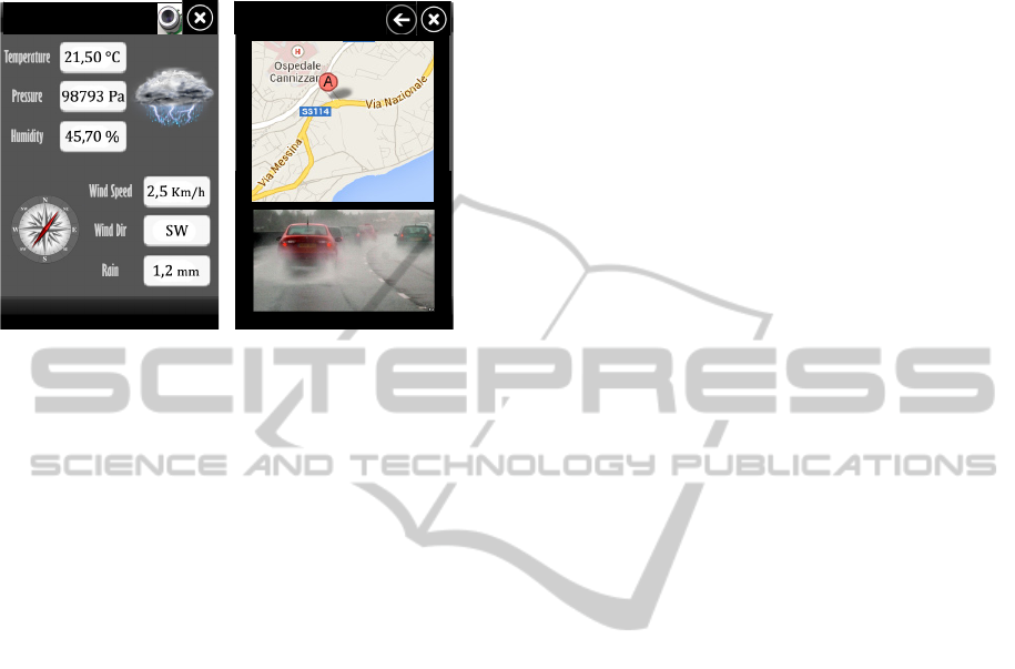
current and previous ambient data on its display as
shown in fig.10 independently on how the data were
collected by the proprietary monitoring systems.
Figure 10: User interface to display on the mobile the road
weather conditions, map and photo in real time.
4 CONCLUSIONS
In the paper we have illustrated how the
implementation of a pervasive ambient intelligence
platform in the IOT era should be based on a
ubiquitous user's model ontology. Indeed, the
availability of cheap and small monitoring devices
addressable through internet is only one side of the
coin, since it is also important that the monitored
data should be open and interoperable.
This clarifies why the dedicated navigators
installed on the cars that don’t take into account the
real time car traffic flows neither the personal and
weather conditions are more and more substituted by
modern applications implemented on the user
mobiles that not only facilitate e-commerce and e-
government operations but also help the people
mobility using timely information coming from field
sensors, as foreseen in (TRG, 2008). In fact, such
data are able to characterize the user status in a
deepened way and the traffic and weather conditions
in real time, thus allowing the DSS to satisfy
effectively the ubiquitous request of user assistance.
However, the available Location Based Services
(LBSs) of this second generation are mainly
proprietary systems, thus they don't meet the basic
requirements of the LBSs inspired by the IOT
paradigm, i.e., the requirement that the data of user
interest should be open and interoperable, as claimed
in (Teller, 2010).
For this reason, the ontology approach until now
used in K-Metropolis for integrating disparate urban
data bases to support user mobility and to provide e-
commerce and e-government services to desktop
PCs and mobiles, was extended, as illustrated in this
paper, to make available to all the DSSs
implemented on the user mobiles the data needed to
provide the users with recommendations that take
into account personal and ambient information that
influence greatly the user activities.
However, due to the lack of an agreed ontology
at urban level, our future work will be mainly the
one to study carefully the available urban ontology,
e.g., (Heckmann et al., 2005) and (Heckmann,
2006), (Teller, 2007), (Berdier, 2007), (Zhai, 2008),
(Faro, 2011b) and (Costanzo, 2013b), to choose the
terminology and related properties that may favour
the implementation of a standard smart city
ontology.
REFERENCES
Acampora G., et al., A Survey on Ambient Intelligence in
Health Care, IEEE Proceedings, Issue 99, 2013.
Aoun C., The Smart City Cornerstone: Urban Efficiency.
Schneider Electric White Paper, 2013.
Banzi, M., Getting Started with Arduino. Make Books,
2009.
Berdier C., Roussey C., Urban Ontologies: the Towntology
Prototype towards Case Studies. Springer, 2007.
Berthon B., et al., Building and Managing an Intelligent
City, online, 2011.
Corlan, M., Flash Platform Tooling: Flash Builder, Adobe,
2009.
Costanzo A., Faro A., Giordano D., Wi-City: Living,
deciding and planning using mobiles in intelligent
cities, 3rd Int. Conf. on Pervasive Embedded
Computing and Communication Systems, PECCS,
Barcelona, 2013.
Costanzo A., Faro A., Towards Open and Interoperable
Information Platforms for Mobile Users: RDF
Methodology and Case Study, IEEE Proc. 7th
International Conf. on Application of Information and
Communication Technologies (AICT), Baku, 2013.
Costanzo A., Pino C., An Arduino based Health
Monitoring System for Elderly People Living at
Home: Functions and Ontology, Int. Conf. on
Physiological Computing Systems, PhyCS, INSTICC,
Lisbon, 2014.
Faro, A., Giordano, D. and Spampinato, C., Evaluation of
the Traffic Parameters in a Metropolitan Area by
Fusing Visual Perceptions and CNN Processing of
Webcam Images, IEEE Transactions on Neural
Networks, Vol.19 (6), 1108-1129, IEEE, 2008.
Faro, A., Giordano, D. and Spampinato, C., Adaptive
background modeling integrated with luminosity
sensors and occlusion processing for reliable vehicle
detection. IEEE Transactions on Intelligent
Transportation Systems. Vol.12(4), 1398-1412, IEEE,
2011.
ViaNazionalec/o
CannizzaroHospital
WEATHERSTATIONN.10
WEATHERSTATIONN.10
PervasiveAmbientIntelligencePlatformsintheIOTErabasedonaUbiquitousUserModelOntology-AnImplementation
Account
77

Faro A., Giordano D., Spampinato C., Integrating
Location Tracking, Traffic Monitoring and Semantics
in a Layered ITS Architecture. Intelligent Transport
Systems, vol.5(3),IET, 2011.
Heckmann D., et al., GUMO, the General User Model
Ontology, LNCS, N.3538, Springer, 2005.
Heckmann D., Ubiquitous User Modeling, IOS Press,
2006.
Leduc, G., Road Traffic Data: Collection Methods and
Applications, Working Papers on Energy, Transport
and Climate Change, N.1, JRC European
Commission, 47967, 2008.
Telematics Reserach Group (TRG), Preview portable
navigation: the future is bright for connectivity.
http://www. telematicsresearch.com/PDFs/
TRG_Press_ Jan_0.pdf.2008.
Teller J., John R. Lee J.R., Catherine Roussey C., (Eds.),
Ontologies for Urban Development, Springer, 2007.
Teller J., Billen R., Cutting-Decelle A.F., Ontology based
approaches for improving the interoperability between
3D urban models. Journal of Inf. Technology in
Construction, 2010.
Zhai, J., Jiang, J., Yu, Y., Li J., Ontology-based Integrated
Information Platform for Digital City. IEEE Proc. of
Wireless Communications, Networking and Mobile
Comp., WiCOM ’08, 2008.
PECCS2014-InternationalConferenceonPervasiveandEmbeddedComputingandCommunicationSystems
78
