
On Human Inspired Semantic SLAM’s Feasibility
Dominik Maximilián Ramík, Christophe Sabourin and Kurosh Madani
Images, Signals, and Intelligent System Laboratory
(LISSI / EA 3956), PARIS-EST Creteil (UPEC)
Senart Institute of Technology, Avenue Pierre Point, Lieusaint, 77127, France
Abstract. Robotic SLAM is attempting to learn robots what human beings do
nearly effortlessly: to navigate in an unknown environment and to map it in the
same time. In spite of huge advance in this area, nowadays SLAM solutions are
not yet ready to enter the real world. In this paper, we observe the state of the
art in existing SLAM techniques and identify semantic SLAM as one of pros-
pective directions in robotic mapping research. We position our initial research
into this field and propose a human inspired concept of SLAM based on under-
standing of the scene via its semantic analysis. First simulation results, using a
virtual humanoid robot are presented to illustrate our approach.
1 Introduction
In mobile robotics, the ability of self-localization with respect to the environment is
crucial. In fact, knowing precisely where the robot is, and what kind of objects sur-
round it in any given moment of the time enables it to navigate autonomously and to
interact with an unknown environment in a conscious manner. An informal definition
of the Simultaneous Localisation And Mapping (SLAM) describes it as a process, in
which a mobile robot explores an unknown environment, creates a map of it and uses
it simultaneously to infer its own position on the map. In the real world SLAM appli-
cations, data association has often to be done under large amount of uncertainty.
Moreover, the real environment is usually very complex and dynamic and it is not
easy for a robot to interpret it in a reliable way. It is this complexity, what makes
SLAM a challenging task. A comprehensive list and principle explications of nowa-
days most common SLAM techniques can be found in [1], [2] and [3]. Although from
its beginning until present days the research community achieved a significant ad-
vance on the field of SLAM [4], it is not yet a solved problem. Autonomous naviga-
tion in dynamic environment [5] or understanding the mapped environment by in-
cluding semantics into maps [6] are the actual challenges of this research field..
In this paper, the state of the art in robotic mapping is investigated. We identify a
relatively new field of research within the field of SLAM, which is attempting to
perform simultaneous localization and mapping with the aid of semantic information
extracted from sensor readings. One of the research interests of our laboratory
(LISSI) is autonomous robotics notably in relation to humanoid robots. We are con-
vinced that the research on semantic SLAM will bring a useful contribution on this
Ram
´
ık D., Sabourin C. and Madani K. (2010).
On Human Inspired Semantic SLAM’s Feasibility.
In Proceedings of the 6th International Workshop on Artificial Neural Networks and Intelligent Information Processing, pages 99-108
Copyright
c
SciTePress

topic. We position our initial research into this field, drawing our inspiration from
human way of navigation and place description. In fact, contrary to most of current
SLAM techniques, which tend to infer precisely and globally the navigation envi-
ronment, the human way of doing is based on very fuzzy description of the environ-
ment and it gives preference to local surroundings of the navigation backdrop. A
simulation using a virtual humanoid robot (Nao robot) is presented to demonstrate
some of the proposed ideas. The real Nao will be used in our further work.
The paper is organized in the following way: section 2 focuses on the state of the
art in semantic SLAM. In the third section, we are discussing our approach to image
segmentation and scene interpretation. Section 4 gives an overview of the robotic
humanoid platform we use. The fifth section presents our initial results and the paper
concludes with section 6.
2 Semantic SLAM
In this section, one of the latest research directions on the field of SLAM, the so-
called semantic SLAM, is discussed. The concept itself may be perceived as a very
important and pertinent one for future mobile robots, especially the humanoid ones,
that will interact directly with humans and perform tasks in human-made environ-
ment. In fact, it is the human-robot interaction, which is probably one of important
motives for employing semantics in robotic SLAM as humanoids are particularly
expected to share the living space with humans and to communicate with them.
Semantics may be incorporated into the concept of robotic SLAM in many differ-
ent ways to achieve different goals. One aspect of this may be the introduction of
human spatial concepts into maps. In fact, humans usually do not use metrics to lo-
cate themselves but rather object-centric concepts and use them for purposes of navi-
gation (“I am in the kitchen near the sink” and not “I am on coordinates [12, 59]”)
and fluently switch between reference points rather than positioning themselves in a
global coordinate system. Moreover, presence of certain objects is often the most
important clue for humans to recognize a place. An interesting work addressing the
mentioned problems has been published in [7], in which the world is represented
topologically with a hierarchy of objects and place recognition is performed based on
probability of presence of typical objects in an indoor environment. A part of the
work shows a study based on results of questioning about fifty people. The study was
aimed to understand human concepts of self-localization and place recognition. It
proposes that humans tend to understand places in terms of significant objects present
in them and in terms of their function. A similar way (i.e. place classification by pres-
ence of objects) has been taken by [8] where low-level spatial information (grid
maps) is linked to high-level semantics via anchoring. During experiments, the robot
has interfaced with humans and performed tasks based on high-level commands (e.g.
“go to the bedroom”) involving robots “understanding” of the concept of bedroom
and usage of low-level metric map for path planning. However, in this work, object
recognition is black-boxed and the robot is not facing any real objects in the experi-
ments but only boxes and cylinders of different colours representing different real-
world objects.
100

An approach treating this “gap” between object recognition and semantic SLAM is
presented in [9]. Here, a system based on a mobile robotic platform with an omni-
directional camera is developed to map an outdoor area. The system generates a se-
mantic map of structures surrounding the robot. Buildings and non-buildings labelled
on the map. In [6], a more general system is presented, employing a wheeled robot
equipped with a laser 3D scanner. Authors show ability of their robot to evolve in an
indoor environment constructing a 3D semantic map with objects like walls, doors,
floor and ceiling labeled. The process is based on Prolog clauses enveloping pre-
designed common knowledge about such an environment (i.e. the doors are always a
part of a wall and never a part of the floor). This enables the robot to reason about the
environment. Further in the paper, an object detection method using the laser range
data is shown with a classifier able to distinguish and to tag different objects sur-
rounding the robot including humans and other robotic platforms. In [10] active ob-
ject recognition is performed by a mobile robot equipped by a laser range finder and a
camera with zoom. A semantic structure is extracted from the environment and inte-
grated to robots map. It allows the robot to reach previously detected objects in an
indoor environment. Another object recognition technique is shown in [11] including
an attention system. Based on recognized objects a spatial-semantic map is built.
3 Image Segmentation and Scene Interpretation
Section 2 showed the pertinence of semantic SLAM in the frame of state of the art
robotic mapping. It is exactly this field, on which we are focusing our research. Our
motivation comes from the natural ability of human beings to navigate seamlessly in
complex environments. Obviously, the way we are orienting ourselves in the space is
very different from what contemporary robots do. To describe a place, we use often
very fuzzy language expressions and approximation (as shown in [7]). This is in con-
trast with most of the current SLAM algorithms. In navigation or place description
people also rarely use “global coordinates” but rather divide the scene into some kind
of hierarchic clusters around distinctive objects, which then act as local origin of
coordinates. Another interesting point is that people are able to infer distance of an
object according to its apparent size and their experience of object’s true size. From
what has been mentioned so far it is clear that recognition of objects and understand-
ing of their nature (semantic treatment) is an integral part of human navigation or
“human SLAM” and not just an extra layer of it. We believe that application of se-
mantics and human inspired scene description could bring a considerable benefit in
development of robust SLAM applications for autonomous robotics.
To initiate a semantic scene interpretation, the image has to be segmented first. Al-
though there exist many approaches to image segmentation (see [12]) for a reference),
not all of them are suitable for purposes of mobile robotics, because it requires image
treatment being done in real time. Our segmentation algorithm breaks the input image
into parts containing similar colors present in different brightness levels. This should
reflect that different shades do not usually mark different objects but only different
light conditions on the same object.
101

We have chosen to use the YCbCr color model within our algorithm. This color
model consists of three channels. The Y channel is dedicated to the luminance com-
ponent of the image and stores the information about light and dark parts of the im-
age. The other two channels Cb and Cr contain respectively the blue and the red
chrominance component of the image. The YCbCr color model is more practical for
purposes of our color segmentation algorithm, than classical RGB. It is because
YCbCr separates the luminance of color and the color itself into different channels,
while in RGB both color and its lightness are mixed together. The algorithm works in
two stages, coarse to fine. In the first one, the Cr and Cb components of the image are
acquired, their contrast is stretched and median filter is applied on both of them to
remove noise. Then a single scan is made through rows and columns of the image and
the first position that is not already occupied by a detected component is chosen as a
seed point with coordinates x
seed
and y
seed
.
Eq. 1 captures how seed point is used to extract a segment of interest (S) from the
image. The P stands for all the pixels in the image, whereas p is the actually examined
pixel. Predicate C is true only if its two arguments (p, p
seed
) are in four-connectivity
and I stands for intensity of pixel. Seed pixel is denoted by p
seed
. A pixel of the image
belongs to the segment S under the following conditions: the difference of intensities
of the current and the seed pixel is smaller than a threshold and there exists a four-
connectivity between it and the seed pixel. Applying this on both chroma sub-images
(Cr and Cb) we obtain segments denoted as S
Cr
and S
Cb
. A new segment S is then
determined following Eq. 2 as the intersection of segments found on both chroma
sub-images without pixels already belonging to an existing segment.
∀p∈P; C(p, p
seed
) & |I(p) – I(p
seed
)| < ε → p ∈ S
(1)
S = S
Cr
∩ S
Cb
- S
all
. (2)
At the end of the scan, a provisory map of detected segments is available leaving
out components whose size is below certain threshold. At this stage, the image is
often over segmented due to the method of selection of seed points. However, it
serves as the first guess about the positions of regions. In the second step, all the
provisory segments are sorted according to their area and beginning with the largest
one the algorithm of segmentation is run again. This time the seed points are derived
from centers of segments defined by Eq. 3 and Eq. 4.
The seed point k
seed
is determined as such a pixel from the skeleton whose dis-
tance from its closest contour pixel is maximal. Here, K is the set of pixels of skeleton
belonging to segment S and C is the set of contour pixels of S. D
i
denotes the minimal
distance between the given pixel k
i
and the contour. In this step, similar segments
from the previous step are effectively merged. At this point, found segments may
contain distinctive areas of different brightness having similar chroma. The ultimate
step of the algorithm is in constructing a histogram of luminance values of each seg-
ment. The histogram is then polished by application of sliding average. If multiple
significant clusters are found in the histogram, the segment is broken-up accordingly
to separate them. Having finished this step, found segments are stored for further use.
102


The choice of languages includes C, C++, Python and URBI and the code can be run
locally on robot’s CPU or distantly via a network connection. After having explored
different ways of programming
Fig. 1. A scheme describing our humanoid robotic platform, showing different possibilities of
programming it. On the left a photo of the real Nao used in our laboratory.
Nao, we have chosen URBI developed by Gostai
3
for development purposes (see
Fig. 1). There are several reasons for this choice. First, URBI is a specific language
developed especially for robotics and by its nature allows simple and fast develop-
ment of robotic behaviors. Moreover, it provides a simple way of managing parallel
processes, which may be a complex task in other languages. Although programming
in URBI involves writing in URBI script, which is then interpreted by an interpreter,
URBI programs do not suffer from lose of performance. The code of its internal ob-
jects is written in C++ to keep high efficiency of the language. LibURBI connectors
allow user to develop own objects using so called UObject architecture and to plug
them into the language. These objects can be developed in C++ or Java code (a con-
nector is available for Matlab as well). User-created objects can be run directly on the
robot or transparently on a remote machine via CORBA technology. With these prop-
erties, URBI seems to us to be suitable for developing complex behaviors on robots
as well as computationally intensive tasks as image processing.
For the demo simulation presented in the next sections, we used the simulated ro-
bot described above and we are going to use its real equivalent in our further research
on the field of semantic SLAM. The task itself may be not perceived as being strictly
specific for humanoid robots. However, the motivation to use a humanoid robots
comes from the fact, that they are specially designed with the aim to interact with
humans and to act in human-made environment. If they are already imitating humans
in their physical form, why should not we enable them to do the same on the level of
their software? The concepts we are exploiting here come from human approach to
navigation and orientation in the space. Thus embedding such human inspired seman-
tic SLAM capabilities onto a humanoid robotic platform seems pertinent to us.
3
http://www.gostai.com/
104
5 Results
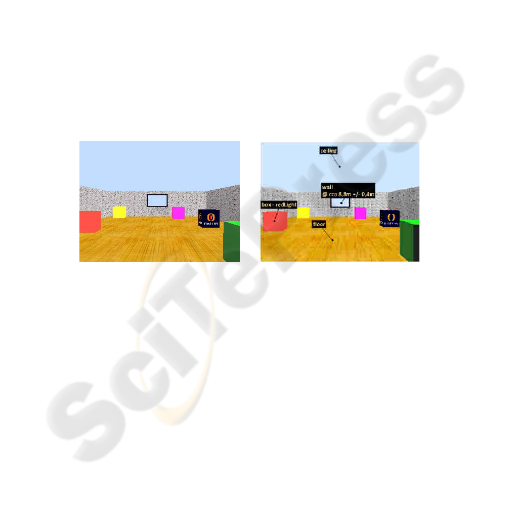
After having the image segmented, all segments are labeled and interpreted by a set of
rules representing prior knowledge about objects. Following the mentioned rules
segments can be even merged so that e.g. multiple fragments of floor partially oc-
cluded by objects laying on it are labeled as belonging to the same object of type
“floor”. Fig. 2 gives an example resulted from the left image (supposed as the original
image acquired by robot’s vision system). Fig. 3 depicts the intermediate steps of
segmentation. This “semantic” information is subsequently used to approximate the
actual distance of certain objects. Having an object of type “window”, it is looked-up
in a table containing usual sizes of different objects and once found the size informa-
tion is used along with the pixel size of the object on the image and the field of view
of the camera to compute the approximate distance of the window (see the right im-
age in the Fig. 2). This is described by Eq. 6 (simplified for horizontal size only). The
distance d to an object is the product of estimated real width w
real
of the object and
tangent of its width in pixels w
px
on the image multiplied by fraction of the horizontal
field of view ϕ and the width w
image
of the image in pixels
d = w
real
* tan ( w
px
* ϕ / w
image
)
(6)
Fig. 2. A view of the robot’s random walking sequence. The left image is the original one. The
right image shows the result after the interpretation phase. Some of the detected objects are
labeled. The opposing wall is labeled also with its approximate distance with respect to the
robot.
The aim of this computation is absolutely not to infer the exact distance of an ob-
ject, but rather to determine whether it is “far” or “near” in the context of the simu-
lated world or if it is nearer to the robot in comparison to another object. This can
help in the further process of creation of the map of the location.
This demo, however limited, gives a preliminary idea of principles of semantic
mapping and more importantly, it gives a starting point for the research in the area of
semantic SLAM. Resigning to precise metric position of every object in the mapped
world and replacing it only by rough metric and human expressions like “near to” or
“beside of” is believed to enable us to create faster and more robust algorithms for
robotic SLAM. Using of “object landmarks” to navigate in an environment is certain-
ly more meaningful that using e.g. simple points in case of classical SLAM. Knowing
105

the nature of an object gives an opportunity to distinguish between important and
random objects. One can imagine a robot with an ability of choosing landmarks for
purposes of its navigation by itself. With the knowledge about available objects, it
could prefer to pick up the most important and stable objects that are unlikely to
change their place or appearance in the lifetime of the map.
Fig. 3. The two segmentation steps relative to the result of Fig. 2.
Fig. 4. The same room with different textures (left) and resulted interpreted image (right).
The seed point k
seed
is determined as such a pixel from the skeleton whose distance
from its closest contour pixel is maximal. Here, K is the set of pixels of skeleton be-
longing to segment S and C is the set of contour pixels of S. D
i
denotes the minimal
distance between the given pixel k
i
and the contour. In this step, similar segments
from the previous step are effectively merged. At this point, found segments may
contain distinctive areas of different brightness having similar chroma. The ultimate
step of the algorithm is in constructing a histogram of luminance values of each seg-
ment. The histogram is then polished by application of sliding average. If multiple
significant clusters are found in the histogram, the segment is broken-up accordingly
to separate them. Having finished this step, found segments are stored for further use.
106

Fig. 5. Detection of the wall as a overall (macro) object in robot’s environment.
It is important to notice the robustness of the proposed approach and the fact that
the estimated distances, even if approximated, are relevant enough for extracting
pertinent features relating environmental information. Fig. 4 gives results obtained
from the right image showing the above-mentioned purpose. Fig. 5 gives an example
of extended possibilities of the technique in detecting environmental information. In
fact, it allows potentiality of a higher-level semantic labeling of objects constituting
the robot’s environment. Here, one can notice that in the given example (detection of
the room’s wall including the associated objects as window, etc…) allows the possi-
bility to link previously labeled objects (for example the window) to the “wall” in
term of “room’s wall with the window”.
6 Conclusions and Perspectives
Simultaneous localization and mapping is an important ability for an autonomous
mobile robot. State of the art techniques have been discussed here giving an idea
about the current state on the field of SLAM. In spite of a great advance in SLAM
techniques in past years, most of the existing SLAM solutions can accommodate only
a particular case or environment. A stable and generally usable SLAM solution is still
missing. Given the state of the art of SLAM, one of the basic directions, which are
expected to play a key role in future development of SLAM is so called “semantic
SLAM”: adding a semantic level into robotic mapping should help robots to go
beyond simple “structural” information about the world that surrounds them. It
should enable them to “understand” it.
In this paper, we identify the pertinence of semantic SLAM for the future devel-
opment in mobile robotics and we present our initial research on this field. Our re-
search is strongly inspired by the human way of navigation and place description. The
semantic information about objects in the scene may improve mapping capabilities of
robots. It should enable them to reason about their environment as well as to share
their knowledge with humans and receive commands using human concepts and cate-
gories in a seamless way.
For description of a scene by semantic means, a good algorithm for image segmen-
tation is an important starting point. Preferably, it should perform segmentation using
both color and texture information. For real time use, fast and efficient algorithms are
107

required. A part of our future work will be dedicated to further development of such
an algorithm. Another part of our future work will be focused on development of
algorithms of semantic SLAM we outlined in this paper. They will be consequently
implanted and verified in an indoor environment on the real Nao robot.
References
1. Durrant-Whyte, H., et al. Simultaneous Localisation and Mapping (SLAM): Part I The
Essential Algorithms. Robotics and Automation Magazine, Vols. 13, No 2, pp. 99-110,
(2006).
2. Durrant-Whyte, H., et al., Simultaneous Localisation and Mapping (SLAM): Part II State
of the Art. Robotics and Automation Magazine, Vols. 13, No 3, pp. 108-117 (2006)
3. Muhammad, N., Fofi, D. and Ainouz, S. Current state of the art of vision based SLAM.
Image Processing: Machine Vision Applications II, Proceedings of the SPIE, Vol. 7251,
pp. 72510F-72510F, (2009)
4. Thrun, S. and Leonard, J. J. Simultaneous Localization and Mapping. [ed.] B. Siciliano and
O. Khatib. Springer Handbook of Robotics. Berlin Heidelberg: Springer-Verlag, 37, (2008)
5. Hahnel, D., et al. Map Building with Mobile Robots in Dynamic Environments. Proceed-
ings of the IEEE International Conference on Robotics and Automation. Taipei: IEEE, Vol.
2, pp. 1557-1563, (2003)
6. Nüchter, A., Hertzberg, J. Towards semantic maps for mobile robots. Robotics and Auto-
nomous Systems. Amsterdam : North-Holland Publishing Co., Vol. 56, pp. 915-926, (2008)
7. Vasudevan, S., et al. Cognitive maps for mobile robots-an object based approach. Robotics
and Autonomous Systems. Amsterdam: North-Holland Publishing Co., Vol. 55, pp. 359-
371, (2007)
8. Galindo, C., et al. Multi-Hierarchical Semantic Maps for Mobile Robotics. Internati. Conf
on Intelligent Robots and Systems (IROS 2005). Edmonton : IEEE, pp. 2278- 2283, (2005)
9. Persson, M., et al. Probabilistic Semantic Mapping with a Virtual Sensor for Build-
ing/Nature detection. International Symposium on Computational Intelligence in Robotics
and Automation. Jacksonville : IEEE, pp. 236-242, (2007)
10. Ekvall, S., Jensfelt, P. and Kragic, D. Integrating Active Mobile Robot Object Recognition
and SLAM in Natural Environments. International Conference on Intelligent Robots and
Systems, 2006 IEEE/RSJ. Beijing: IEEE, pp. 5792-5797, (2006)
11. Meger, D., et al. Curious George: An attentive semantic robot. Robotics and Autonomous
Systems. Amsterdam : North-Holland Publishing Co., Vol. 56, pp. 503-511, (2008)
12. Lucchese, L. and Mitra, S. K. Color image segmentation: A state-of-the-art survey. Proc.
Indian Nat. Sci. Acad. (INSA-A). Vols. 67-A, pp. 207-221, (2001)
108
