
MULTI-TIER BASED VISUAL COLLABORATION
A Model using Semantic Networks and Web3D
Eldar Sultanow and Edzard Weber
Business Information Systems and Electronic Government, University of Potsdam, Germany
Keywords: Distributed development, Collaboration, Visualization, Semantic networks, Web3D.
Abstract: Geographically distributed development has consistently had to deal with the challenge of intense awareness
extensively more than locally concentrated development. Awareness marks the state of being informed
incorporated with an understanding of project-related activities, states or relationships of each individual
employee within a given group or as a whole. In multifarious offices, where social interaction is necessary
in order to distribute and locate information together with experts (as well as their availability etc.),
awareness becomes a concurrent process which amplifies the exigency of easy routes for staff to be able to
access this information, deferred or decentralized, in a formalized and problem-oriented way. The
appropriate visualization and navigation of this information is a requirement for ensuring that staff and
project managers can orientate themselves most efficiently. This paper develops a model for visualizing the
collaboration in development projects using semantic networks and Web3D.
1 INTRODUCTION
In accordance with the description of collaboration,
metadata systems are suited for application to
virtually any contingent object (Schmaltz, 2005). A
metadata system uses, stores and generates data on
arbitrary objects. The importance of these objects
should be automatically recorded, thus making
particular linguistic differences such as ambiguities
easy to overcome in the future. The objects are
based on a formalization concept, such as those used
for taxonomies and thesauri, which provide the
foundation for semantic networks. A semantic
network is a representational form of knowledge
which illustrates excerpts of reality as a graph
containing a node-set and a set of edges. The first set
describes the objects from reality while the latter
describes the relations of these objects to each other.
There is a majority consensus on the use of
semantic networks in order to portray collaborative
objects as well as their relations to each other. See
the Aether model (Sandor et al., 1997), the event
oriented model (Fuchs et al., 1995) and the Model of
Modulated Awareness, shortly termed as MoMA
(Simone and Bandini, 2002). Semantic networks are
well-structured, flexible and intuitive. They allow
transparency in important relationships and allow for
a context-menu of concept chains. In the search for
objects, access paths are predefined through the
specified set of edges.
A concrete implementation of semantic networks is
Topic Maps (TM), its conceptual and technical
aspects are held by the Topic Maps standard family
(for an overview see Maicher, 2007).
A Topic Map consists of Topics, Associations
and Occurrences (the so-called TAO principle).
Topics are formed from things in reality that
transcend the Associations. Occurrences are
references to further information on Topics in
external documents. The informational content is not
included in the Topic Map itself.
The definition for Web3D is extensive. In a
wider sense, Web3D is a generic term for all
techniques identifying the three-dimensional
visualization of the content on the Internet. It
involves the use of three-dimensional computer
graphics in web applications, usually through a
browser plug-in for the use of 3D models. In the
strictest sense, this means the standard X3D
(Extensible 3D) that is developed and maintained by
the Web3D Consortium. This standard can be used
for the web-based depiction of three-dimensional
objects and scenes described in XML and because of
its backward compatibility, importing existing
VRML models.
159
Sultanow E. and Weber E.
MULTI-TIER BASED VISUAL COLLABORATION - A Model using Semantic Networks and Web3D.
DOI: 10.5220/0002783601590166
In Proceedings of the 6th International Conference on Web Information Systems and Technology (WEBIST 2010), page
ISBN: 978-989-674-025-2
Copyright
c
2010 by SCITEPRESS – Science and Technology Publications, Lda. All rights reserved
Two aspects of this technique, with consideration
to their integration using the model that has been
introduced in this paper, are:
The intuitive navigation and visualization of
large quantities of information with the help of
semantic networks, and
The interaction of project members in different
location or times in the four-dimensional time-
space-system as world metaphors, close to
reality based on cartographic geo-
visualization.
2 MULTI-TIER ARCHITECTURE
The core requirement of a model for the
visualization of collaboration lies in its illustrative
aptitude for depicting the essential characteristics of
a coalition, including the amount of people involved,
the activities they do and the objects they use, as
well as their relations to each other.
The model presented here distinguishes between
three levels of representation, which all serve as a
kind of detail:
World view (macro view): Core members of
the global development network and channels
between them;
Location view (meso view): Local
offices/business units, located partners and
relevant site-related infrastructure
View of the business unit (micro view):
workplace, roles, responsibilities and artifacts
Staff and project activities are specifically
presented to each case at each corresponding level.
The threefold division presented above is pragmatic
– in very large organizations even intermediate
stages could be conceived. Entities in the micro view
(roles) are atomic. The elements of each level are
displayed using a semantic network. This may, in
turn, be described by some element of a semantic
network in a subordinate detail. Their technical
implementation may, for example, be described in
the ways mentioned above (Sultanow, 2005, 2006).
The user can apply the information needed to
filter out criteria at each level. Relevant criteria
include projects and their components, enterprise,
skills, industries and artifacts. The filtration itself is
based on a search using semantic query languages
for Topic Maps like Tolog or TMQL (Topic Map
Query Language).
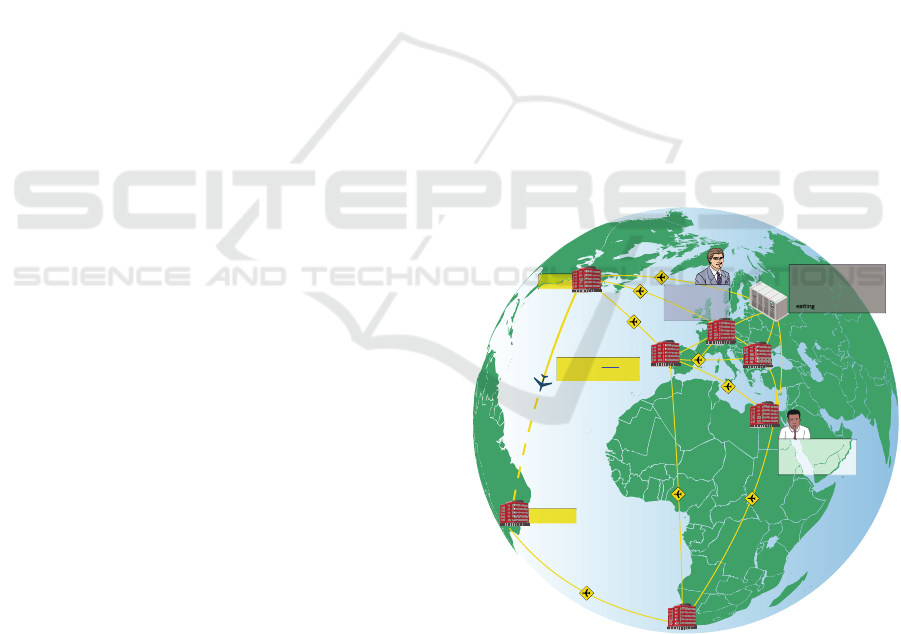
2.1 Macro View
The perspective from the first levels looks at the
locations of the core members, including their
connections, as shown in figure 1. This can be, for
example, a software development office in Munich
and a testing division overseas with a (possibly
automated) transfer of test artifacts and result
protocols. It takes into account the principle and the
available channels between these locations. These
connection types can vary, from lines of
communication to those used for people, data or
handling of materials. Each connection contains
sensitive information such as formats to be used for
data exchange, timetables, transportation policies,
organization-specific requirements, limitations or
forms.
An established connection between two entities
is a channel in accordance with this model. Here,
however, this can differ from the concrete form. The
internal representation as well as the visualization
looks at the mail server, data pathways and user
devices as one entity, similar to travel routes
consisting of flight connections, taxi connections
and intersections (e.g. an international airport). The
existence of a channel, not merely its appearance, is
thus the main focus.
RiodeJaneiro
DataCenterMoscow
4.20amError:CPU temperature
abovethreshold
6.00amError:SlaveI/Othread
AirCargoUnit 15294
ETA:9.35pmRiodeJaneiro
New York
Mr. Kamal,CIOCairo
5.18pm:HelloMr.Stein.
ServersinMoscowneed
special cooling.
Mr.Stein,CFOBerlin
5.20pm:Thank you
Mr. Kamal!Anorder
hasbeenplaced.
Figure 1: The world-view of global collaboration.
2.2 Meso View
The second presented layer provides a detailed view
of individual sites. It lists those sites and channels
that are only noteworthy for the establishment of
network development at any one particular regional
WEBIST 2010 - 6th International Conference on Web Information Systems and Technologies
160
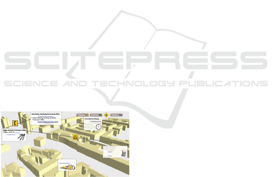
site. These could include advertising agencies,
hardware suppliers, travel agencies or office
suppliers, who are only interested in this particular
regional site to implement and maintain its value-
added work. Their existence is not of any interest for
network members in other locations as they would
already have their own regional supply network at
the other locations. No doubt, this also includes the
most expeditive regional delivery services such as
those implemented for pizza delivery – which keeps
up the performance and morale of employees
working extra shifts.
Analogous to the macro view, this view also
shows the established link between regional
locations. The focus on visualization is once more
primarily on the mere existence of these connections
rather than their actual design. On the other hand,
there are institutions which act as an interface in
order to facilitate connecting with other sites and to
function as regionally significant sites. Thus, an
airport is not part of a regional connection but is an
end junction of a separate component of regional
infrastructure. There may be a user who retains the
power to cross-site links.
The example scenario displayed in figure 2
shows an urban area, in the business’ warehouse,
web design and marketing operation. This is
displayed together with flight, bus and taxi
connections. Individual documents, such as project
reports, flight schedules or delivery confirmations
are linked together and are formed in the Topic Map.
Other visualized elements in the second
representational level are links to courier services
and telephone accessibility.
11.30am: CampaignReport2009published
3.00pm:
inprogre ss
posters
and digitalprintsin
progress
Equipment&SupplyIn v e nt o r y
7.40am Receipt: cargo
unit 15294
9.10am Receipt: cargo
unit 16399
Updated FlightSchedule
for Fe br uary2009
PizzaService
Menu card2009
Figure 2: Departments and local infrastructure (rendered
with LandXplorer CityGML Viewer).
2.3 Micro View
The third and final level is semantically linked to the
places of employment, positions, roles and project
artifacts. This level details the view of individual
business units. It further displays the principle as
well as all of the available channels. Jobs are
associated with artifacts (documents), whereby job
descriptions or access rights act as additional
information which can be complemented in the form
of occurrences.
The micro view also extends to the people; but as
a rule they are assigned to their according jobs,
positions and roles. Links may be between jobs,
positions and given roles. Such connections
represent the exchange of documents which belong
to their related objects. Direct links between separate
actors represent the exchange of tacit knowledge.
Personal knowledge may not be treated as an
attachment to a job, position or role.
Actors are yet another feature by which they can
exercise any detail. Human actors (artificial actors
are also possible in principle) also have the ability to
use the channels which are visually available in the
macro, meso and micro views. When they are in the
relevant period of use in any one given channel, then
they will be visualized. Additional information about
the current activity will be then be treated as an
occurrence and displayed accordingly.
Activities are always addressed by at least one
actor and are treated as Topics. The visualization
not only show those as directly neighboring objects
of the involved actors, but also at the depicted
connection lines which offer the channel for this
activity. These relationships between activities and
actors as well as those with each other are displayed
spatially. Topics, and in particular, activities, may
vary according to their temporal occurrence and can
be faded in and out. This provides an opportunity to
visualize temporal relationships.
Figure 3 shows the structure of a business unit in
a dynamic view. It serves to show how two actors
interact with each other. This could be, for example,
a phone call or a sent fax.
Various activities of actors have already been
featured in figure 1. The communication aspect was
related to the first level (macro view) of project
members blended in at globally distributed sites to
synchronously communicate with each other, such
as instant messaging or VoIP (Voice over IP)-
conferences.
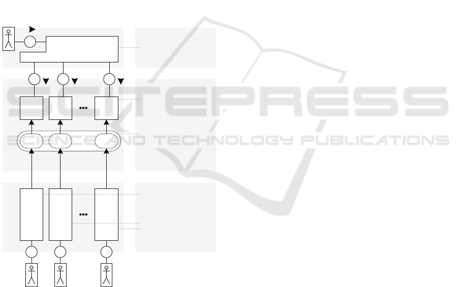
3 TECHNICAL REALIZATION
The model shown here is realized as a presentable
prototype (see figure 4) which introduces separate
Web Services and provides specific visual
information to a client including geo positions of
settlements, branches, business units, conferences,
alerts from IT systems and event notifications. The
MULTI-TIER BASED VISUAL COLLABORATION - A Model using Semantic Networks and Web3D
161
Dave Walter
MikeThomes
Graphic&ProductDesigner
Posters&Prints
Design
Development
8.30pm
agreement
on deadline
Figure 3: Employees, Artifacts and Activities.
client application displays this information
appropriately in the spatial reference system.
In the macro view, the application uses API
functions, which displays labeled objects at specified
geo positions on a rotating earth – distinguished by a
globe covered with a world map. Two organizations;
namely, the OGC (Open Geospatial Consortium) and
the ISO defined the standard GML (Geography
Markup Language) as an interchangeable GIS
(Geographic Information System)-format on the
Internet.
In the meso view the topographical information
model CityGML (City Geography Markup
Language) is used. It was developed by the Special
Interest Group (SIG) and has been adopted by OGC
as an international standard. CityGML is a GML
application schema for describing three-dimensional
city and landscape models.
In the micro view, network-like graphs such as
those in the “They Rule Project” (theyrule.net) which
display the relations between some of the most
influential economic U.S. leaders will be shown.
Various network graph visualizations of complex
relationships are given by a comprehensive
compilation of more than 630 projects
(visualcomplexity.com).
As shown in figure 5 the systems architecture is
layered: External applications generate data due to
business and development processes or by
participation in development training (where the
skills-database is ever growing). Third party services
and mobile devices generate data such as the
updating of vehicle/flight times and training sessions,
seminars, etc. To ensure that the information is linked
in a semantic network and can be visualized, they are
intertwined within the topic map layer. The linking is
done manually and automatically, for example, if an
employee links requirement documents or test case
documents through web-uploads. Finally, the graphic
representation of the information or the web-based
search is carried out in the client/GUI layer, filtering
and accessing information and the relevant
documents. The GUI client application is written in
Java and uses the NASA World Wind API, an interface
providing GIS capabilities.
The technical basis of each of the three levels of
representation is built upon two frameworks. The
first is a web-enabled visualization system – a Java
Applet or Webstart application using NASA World
Wind API.
Figure 4: Screenshot of implemented Prototype.
The second is a TM-Framework – this concerns
an ISO-13250 reference implementation (TM4J,
Ontopia Knowledge Suite, etc.), which allows the
creation, editing and processing (for the graphical
representation) of Topic Maps.
All delivered content is requested and displayed
over filters and is managed in different systems and
formats. Geographical information is referred to in
WEBIST 2010 - 6th International Conference on Web Information Systems and Technologies
162
spatial data which is stored in diverse formats such as
GML and can be obtained in World Wide Web
exempt from charges (Margaria and Sultanow, 2008).
Timetables are retrieved in XML format. Event
messages are delivered by monitoring and warning
systems, such as those exposed by the Nagios
software in the technical administration environment.
Project management related data, which is linked in
the Topic Map, contains status reports and other
project documents delivered by a CMS (Content
Management System) or a project management
platform.
The use of project and bug tracking systems
offers awareness information about developments,
activities and task dependencies. The Topic Map
also contains all staff contact information and data
pertinent to their skills, IM profiles (Skype or ICQ
usernames). All of this information ultimately serves
as an integration basis for various interactive and
synchronous communication applications.
WS
1
WS
2
WS
N
Web Services
DB
TM
1
TM
2
TM
N
R R R
External Apps.
Mobile App.
Enterprise
App.
Third Party
Services
Topic Map Data
Send current Geo
Positions of People,
Supplies
Store Logentries,
Metainformation on
Projects, Documents
DB contains raw Topic
Map Material to be
interconnected: Skills,
Experts, Locations
A Web Service returns
appropriate dataset
upon requests e.g.:
<All Web Engineers
located in Berlin>
Client Application
displays data (provided
by WS) in graph form on
a visual globe
R
NASA World Wind API
Visual Client
Figure 5: Mobile and Enterprise Applications produce data
which will be linked into a semantic web.
4 LIMITATIONS
The success of this collaborative model and the
subsequent building tools produced depends not
only on the quality and quantity of data, which is the
basis for the visualization of the collaboration form,
but simultaneously on several other conditions. Data
production can be technically complicated and can
either take up copious amounts of time or virtually
no time at all. Both discipline and personnel are,
however, required for productivity. The key to
finding the right balance between benefit and burden
must be identified by each user.
One major problem is how to coordinate the
paradigmatic necessity of transparency in order to
support work coordination juxtaposed against the
privacy rights of the workers observed (Dourish and
Bellotti, 1992). When personal data is at hand, data
protection rules must sufficiently be taken into
account. This challenge, however, has to be made
with almost all measures related to knowledge
management. Nonetheless, without the consent and
voluntary participation of the users such a tool
cannot be fully utilized because the employees are
not only users but are also participants who should
ideally be voluntarily entering into the non-informal,
non-automated activities. Indubitably, then, on the
employee-level a stable balance is to be made
between individual benefits and burdens.
5 EVALUATION IN COMPANY
PRACTICE
Within scientific literature, different sources are
often cited regarding models with respect to the
identification and classification of their benefits to
business software. Some such benefit models were
developed by (Shang and Seddon, 2002, Gable et al.,
2003, Schubert and William, 2009). The Schubert
and William model subdivides the benefit into levels
similar to that of Shang and Seddon. As a result, five
levels are distinguished (table 1), in which tangible
benefits can be clearly obtained through the use of
the business software. Measurable criteria can be
determined for every beneficial element, such as the
availability of information on the level of
management. In this manner different benefit-
describing triplets (level, element, criterion) can be
formed. The specification capacity and intuitive
structure of the model led to the decision to use it as
a basis for the evaluation.
For the evaluation, staff in eight small to
medium-sized businesses (table 2) in the areas of
development, leadership and organization were
introduced into a prototypical system and
interviewed. Subsequently, a discussion took place
regarding the benefits to the specific business needs.
To this extent, the general reaction of the participants
was positive in the way, that they took on the 3D-
MULTI-TIER BASED VISUAL COLLABORATION - A Model using Semantic Networks and Web3D
163
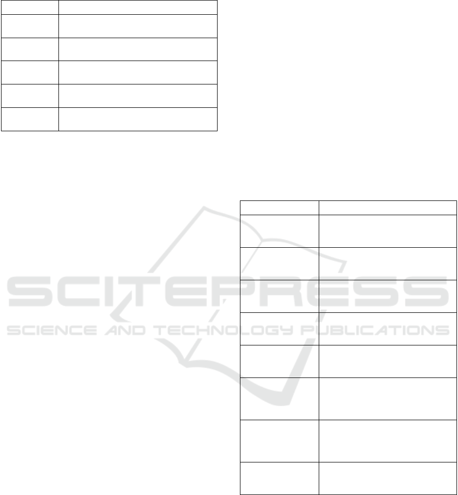
Table 1: Levels of benefit from using business software
(Schubert and William, 2009).
Level Beneficial-elements
Business
Design
Structure and Processes: Control structures,
Business Processes and Workflow
Management Resources: Finance, Staff, Information,
Products and Strategy
Department Functions: PR/Marketing, procurement,
Production and Sale
Supply Chain Participants: Suppliers, Partners and
Customers
Information
Technology
Technological elements: Applications,
Databases and Operating Systems
Visualisation and GUI, acknowledging it and using it
intuitively. Following the guidelines of this graphic
representation and navigation, there were at least two
occurrences where participants raised concerns about
data protection.
Chiefly, the knowledge around the current
location of persons, documents and products was
perceived as useful because one could be directly
lead to immediate or presumed accessibility.
On the management level of the model of
Schubert and William, benefits were identified in all
companies, which exist in the increase of the
volume, availability and depth-of-detail depth of
information, and therefore in the creation of an
increased awareness for information that is likely to
be sought out. In addition, three companies named a
financial benefit on the same level – the cost-cutting
through dissolution of media gaps.
A pharmaceutical distributor identified the
quality-security and forgery-security of products, in
this case: medicine, as a further benefit. By invoking
the visualization of medicine flow irregularities could
be detected, such as the purchase of large quantities
that do not re-appear on the market. Such "black
holes" within this industry can lead to illegal export,
forgery and manipulation of the products. To the
question with regard to the advantage of the three-
dimensional real time presentation, staff stated that
they could quickly grasp visual information and
would prefer this to previous information
representation methods on the basis of number tables,
for example. Four Companies identified a benefit on
level of the information technologies which exists
therein, that the meaningfulness of stored data (in
databases) would increase by its semantic networking
as well as the usability of this more meaningful data
in existing business applications. A company in the
e-commerce-area named the use of the real-time
delivery data for SCM and CRM applications as an
example, out of which a benefit arises on the level of
the departments, because of the awareness increase
for procurement and sale.
Another example presents a company operating
in worldwide import/exporting construction material
which not only wants to make visible storage depots
and routes for supply transportation on a visual globe
but also the cargo itself at its current location. This
company also communicated the desire to display
important routes as well as weather and traffic
conditions, which can be retrieved by several
external services from third party sources.
Still another example is a company in the internet
business which manages and operates server farms.
They expressed the aspiration to display its
datacenters, which are covered all over the world,
together with current power consumption and
electricity rate as dependent on each location.
Table 2: Business profiles of interviewed companies.
Area of operation Activities
E-Commerce Portal development: Provision of
product, offer and consumer
information
Search Engine
Optimization (SEO)
Online Marketing, competition
analysis, structural optimization of
web pages for search engines
Pharmaceutical
distribution
Forgery security, web-based real time
QS, Track-&-Trace and condition
control of medicine
Online Community Portal for organizing and
administrating interests-group-specific
events
Design Led
Innovation (DLI)
Elevation of market and user
demands, solution conception, user
feedback driven software development
Intercultural
exchange
Assisting international
communication, construction of
culture spreading cooperations,
organizing culture events
Global
import/export of
construction
material
Storage, international sales,
marketing and import/export of
construction materials
Customer
Acquisition in
WWW
Online marketing of security
technologies and systems for
renewable energies
These are all examples for the preliminary
requisites for evaluating the model in companies.
This evaluation is currently in progress and will
ultimately result in specific requirement
specifications for individual business needs.
WEBIST 2010 - 6th International Conference on Web Information Systems and Technologies
164

6 FURTHER APPLICATIONS
AND OUTLOOK
It is not the primary intention of this approach to
visualize process models. Nevertheless, it provides a
n extension to process tools. On one hand, the
immediate environment in which the business
processes run is shown; on the other hand, such
activities which appear unsystematic or have no
direct value-added character are presented and can
also be taken into consideration. Information on
such informal activities (i.e. conversations in the
corridor, spontaneous discussions, long-term
training in a subject) cannot be extracted from
databases. There are modeling and survey methods
such as KMDL (Knowledge Modeling and
Description Language) to formally capture informal
trains of thought, typical for any personal form of
knowledge (Gronau et al., 2005, Fröming and
Fürstenau, 2007).
A visualization of one’s own collaboration is
only one purpose for the presented model. It can also
apply to the activities of competitors that are
developing similar products, where often the same
regional partners are involved. The crucial keyword
here is product piracy and its defense (Bahrs and
Vladova, 2009). Important decisions will provide the
average amount of one’s own Topic Map, and those
representing the competitors. Who, from where and
to which network has had contact with whom, when,
how and why? This tool can be used as a monitoring
device to control one's own network so that the
contacts and knowledge flow to competitors and
their partners can be purposely channeled out.
Search engines are used to quickly locate
required objects and always exist in data from a
collected part and from a query part. The introduced
method for the visualization of collaborative
networks as well as the navigation through the
functions of these is covered by a search engine.
However, it is a semantic search, which allows the
user an entry point in the Topic Map, graphically
processed and examined about the advisability,
semantically relevant neighboring objects context-
specific search. The visual background of using
Web3D technologies provides an extensive GUI
(Graphical User Interface) for semantic search, and
additionally prepares the search results without
omitting the visual context.
An implementation of the approach presented in
this work is done here at the University of Potsdam.
Addressed here are the various sub-disciplines of
applied and practical computer sciences, such as
semantic technologies, process management,
geographic information systems, experience from
the software engineering, knowledge management
and web technologies.
REFERENCES
Bahrs, J., Vladova, G., 2009: Produktpiraterie –
Prävention statt Reaktion. Wissensmanagement
1/2009.
Dourish, P., Bellotti, V., 1992: Awareness and
coordination in shared workspaces, in ACM Conf. on
Computer Supported Cooperative Work (CSCW'92)
(Turner, J. K., R.E., Ed), pp 107-114, ACM Press,
Toronto, Canada.
Fröming, J., Fürstenau, D., 2007: KMDL v2.1 - Eine
semiformale Beschreibungssprache zur Modellierung
von Wissenskonversionen. Arbeitsbericht WI-2007-
01.Universität Potsdam, Lehrstuhl für
Wirtschaftsinformatik und Electronic Government.
Fuchs, L., Pankoke-Babatz, U., Prinz, W., 1995:
Supporting Cooperative Awareness with Local Event
Mechanisms: The GroupDesk System. Proceedings of
the fourth conference on European Conference on
Computer-Supported Cooperative Work.
Gable, Guy G.; Sedera, Darshana; Chan, Taizan, 2003:
Enterprise Systems Success: A Measurement Model.
Proceedings of the Twenty-Fourth International
Conference on Information Systems.
Gronau, N., Müller, C., Uslar, M., Weber, E. et al., 2004:
KMDL: Eine Sprache zur Modellierung
wissenintensiver Prozesse nach dem SECI-Modell.
Proceedings der LWA 2004, Gesellschaft für
Informatik, pp 237–244.
Maicher, Lutz, 2007: Autonome Topic Maps. Zur
dezentralen Erstellung von implizit und explizit
vernetzten Topic Maps in semantisch heterogenen
Umgebungen. Dissertation, Universität Leipzig.
Margaria, T., Sultanow, E., 2008: Geodaten: Quellen und
Zugriffsmöglichkeiten. iX, Vol. 2008-09 (September
2008), pp. 139-142.
Sandor, O., Bogdan, C., Bowers, J., 1997: Aether: An
Awareness Engine for CSCW. Proceedings of the
Fifth European Conference on Computer Supported
Cooperative Work.
Schmaltz, R., 2005: IT-Unterstützung für das
Wissensmanagement in Kooperationen. Dissertation,
Universitätsverlag Göttingen.
Schubert, Petra; William, Susan P., 2009: An Extended
Framework for Comparing Expectations and Realized
Benefits of Enterprise Systems Implementations.
Proceedings of 15th Americas Conference on
Information Systems.
Shang, Shari; Seddon, Peter B., 2002: Assessing and
managing the benefits of enterprise systems: the
business manager's perspective. Information Systems
Journal, Volume 12, No. 4, Blackwell Publishing.
MULTI-TIER BASED VISUAL COLLABORATION - A Model using Semantic Networks and Web3D
165

Simone, C., Bandini, S., 2002: Integrating awareness in
cooperative applications through the reaction-diffusion
metaphor. CSCW Journal.
Sultanow, E., 2005: Integration und Visualisierung von
XML Topic Maps. Java Spektrum, 2/2005.
Sultanow, E., 2006: Eine GUI-Anwendung für die
Bearbeitung von XML Topic Maps. Java Spektrum,
4/2006.
WEBIST 2010 - 6th International Conference on Web Information Systems and Technologies
166
