
THE GEOSPATIAL SEMANTIC WEB
Are GIS Catalogs prepared for This?
Carla Geovana N. Mac
´
ario
1,2
and Claudia Bauzer Medeiros
1
1
Institute of Computing, University of Campinas - UNICAMP, P.O.Box 6176, Campinas, SP, Brazil
2
Embrapa Agriculture Informatics, Embrapa, P.O.Box 6041, Campinas, SP, Brazil
Keywords:
Geospatial Data, Geospatial Semantic Web, GIS Catalogs, Interoperability on the Web.
Abstract:
Geospatial information catalogs are complex infrastructures that store and publish geographic information.
They are an important part of Geographic Information Systems (GIS), systems that manage geospatial data for
a wide variety of application domains. To be useful, a catalog must efficiently support discovery and retrieval
of geospatial information, working as a key component for planning and decision-making in a variety of do-
mains. Catalogs use standards to support data interoperability. However, the simple adoption of standards and
specifications for geospatial data description enables only syntactic interoperability. Semantic heterogeneity
still presents challenges for the so-called Geospatial Semantic Web. This work discusses some features that
GIS catalogs should have, focusing in semantic issues. We tested some existing and well known catalogs,
comparing them by means of these features. Based on this comparison, we identified some open issues that
should be addressed considering advanced Geospatial applications on the Web.
1 INTRODUCTION
The term geospatial data refers to all kinds of data
on objects and phenomena in the world that are asso-
ciated with spatial characteristics and that reference
some location on the Earth’s surface. Examples in-
clude information on climate, roads, or soil, but also
maps or telecommunication networks. Such data are a
basis for decision making in a wide range of domains,
ranging from studies on global warming to those on
urban planning or consumer services.
For example, geographic applications for con-
sumer services, like those provided by (Borges et al.,
2007) and (Jones et al., 2003), assign a location to
Web pages, based on existing geospatial evidences,
such as addresses and phone number. This informa-
tion can be subsequently used, for example, to find
consumer services using fuzzy queries and to corre-
late Web pages spatially. In emergency management,
geospatial information can be useful to identify ar-
eas prone to disasters (Klien et al., 2004) or to help
in traffic control. In agriculture they are very useful
for agroenvironmental planning (Mac
´
ario et al., 2007;
Mac
´
ario and Medeiros, 2008), providing means to en-
hance agricultural productivity.
The Web plays an important role in this sce-
nario, having become a huge repository of distributed
geospatial information. Data are collected and stored
by different organizations, which are required to ex-
change such data. These distributed data may be re-
trieved and combined in an ad hoc way, from any
source available in the world, extrapolating their local
context. Usually, the search for these data and meth-
ods is done by their syntactic content, focusing pri-
marily in keyword matching. This can lead to retrieval
of irrelevant data, and to omission of relevant facts.
Hence, semantic interoperability is also a key issue in
discovery, access and effective search for data in dif-
ferent application contexts. Solutions must take into
account the constant modifications in the real world,
and the evolution of our knowledge about the world.
There is a large amount of research on the
management of geospatial data, including proposals
of models, data structures, exchange standards and
querying mechanisms. One area of activity concerns
the so-called Geographic Information System (GIS)
catalogs. These work as metadata catalogs that can
be indexed by various means, such as by geographic
location, and provide support for users to search for
the data in different GIS data repositories. Catalogs
are based on a common set of ideas which do not take
semantic interoperability into account. This is a criti-
cal function necessary for advanced GIS applications,
specially in the context of the Geospatial Semantic
335
Macà ˛ario C. and Medeiros C.
THE GEOSPATIAL SEMANTIC WEB - Are GIS Catalogs prepared for This?.
DOI: 10.5220/0001839403350340
In Proceedings of the Fifth International Conference on Web Information Systems and Technologies (WEBIST 2009), page
ISBN: 978-989-8111-81-4
Copyright
c
2009 by SCITEPRESS – Science and Technology Publications, Lda. All rights reserved

Web (Egenhofer, 2002). In this work we identify im-
portant criteria that must be met by catalogs. Based
on the results of comparing six widely used catalogs,
we point out issues for research and development in
the Semantic Web context. This discussion points at
directions that must be followed in order to enhance
the interoperability of GIS on the Web.
2 RELATED CONCEPTS
2.1 Geospatial Semantic Web
The Semantic Web was initially proposed by Berners-
Lee (Berners-Lee et al., 2001) as a way to bring struc-
ture to the meaningful content of Web pages, creating
an environment where users can obtain information
based on semantics and not only in syntax. In this sce-
nario, the Semantic Web would enable machines to
comprehend semantic documents and data, through:
(1) adoption of standardized data element names to
describe and exchange the data; (2) description of in-
formation in terms that allow common understanding;
(3) exposing data to be found and retrieved; (4) de-
signing efficient retrieval mechanisms.
A standard establishes the name of data elements
(metadata) and/or groups of these elements, providing
a common set of terminology and definitions for the
description and exchange of data. The adoption of a
common vocabulary in this description ensures that
data producer and consumer share the same under-
standing of data. Hence, in the Semantic Web, the de-
scription of the meaning of data using ontology terms,
through standardized metadata is a way to provide se-
mantics, increasing interoperability. This description
process is called annotation.
The Semantic Web for geographic information,
called Geospatial Semantic Web by Egenhofer (Egen-
hofer, 2002), is a way to process requests involving
different kinds of geospatial information. This re-
quires the development of multiple spatial and do-
main ontologies, their representation in a way that
computers can understand and process, the process-
ing of queries considering these ontologies and the
evaluation of results based on the required semantics.
All of this leads to the search for a geospatial infor-
mation retrieval framework that relies on ontologies,
allowing users to retrieve desired data based on their
semantics.
In spite of several efforts, the Semantic Web is
far from becoming a reality (Shadbolt et al., 2006).
Although several standards have been developed and
adopted, there are too many variables that need to be
considered. The variety of user profiles and needs,
and of application domains – and thus of ontologies –
are just some of these factors. So far, most retrieval
engines are restricted to text, and other kinds of me-
dia pose countless challenges to the effective implan-
tation of the Semantic Web (Mac
´
ario and Medeiros,
2008).
2.2 Geospatial Catalogs
Catalogs are complex structures that enable data to
be found and retrieved, through the publishing of de-
scriptions of these data by metadata, known as anno-
tations (Nogueras-Iso et al., 2005), and operations on
these annotations. Catalogs offer search mechanisms
that access them to retrieve the desired data.
A GIS catalog is a Web application to publish de-
scriptions of geospatial data, enabling users to search
for the desired data (OCG, 2006). Because of stan-
dardized interface specifications, different users can
access them from all kinds of sites to search for the
content they need.
The Open Geospatial Consortium, OGC (OCG,
2006) is a non-profit international organization that
is leading the development of standards for geospa-
tial and location based services. The consortium aims
at interoperability among geospatial systems, mak-
ing complex spatial information and services acces-
sible and useful to all kinds of applications. It de-
scribes three basic operations that a geographic cat-
alog should provide: publication, discovery and re-
trieval of geospatial metadata.
Geospatial data is described by metadata and these
descriptions are published in a catalog to support data
discovery. Data discovery can be performed either
by browsing the content of the catalog or by choos-
ing certain query terms. Once the desired metadata is
found, the data referenced can be retrieved.
3 DESIRABLE GIS CATALOG
FEATURES
In a Web environment, GIS users need to explore
available databases to discover the desired informa-
tion. In order to find the data, the first step is to search
for specific GIS catalogs and, once connected to the
catalog, look for candidate metadata describing the
desirable data. As the needed data is found, the users
can download and use it in theirs applications.
However, this is not an easy task to perform.
Geospatial data are complex, due to their spatial com-
ponent and its dynamic characteristics. Besides this,
users are hampered in their queries because of the
many different concepts and terms used to describe
WEBIST 2009 - 5th International Conference on Web Information Systems and Technologies
336

data items. Catalogs seldom publish semantic anno-
tations. One possible approach for this is the use of
terms of an ontology to describe data, helping to re-
move the ambiguity. The increase in quality of the re-
trieved information and enhanced interoperability are
some benefits from the adoption of semantic descrip-
tions, also known as semantic annotations. Although
there is extensive research in geospatial semantics,
it is focused mainly in the adoption of standardized
data element names and of ontology terms to describe
the data. It is not common to find semantic catalogs,
which are those that publish semantic annotations and
support search on them as a way to enhance the re-
trieval of information. In this section we describe
the main features that a catalog should provide in or-
der to make the Geospatial Semantic Web a reality.
These features are based on those presented by (Lar-
son et al., 2006) and (ESRI, 2003), always consider-
ing the user viewpoint.
Feature 1: OGC Compliance. One of the many
standards proposed by OGC is the Catalog Services
Interface Standard (CAT), which supports the ability
to efficiently publish and search collections of meta-
data about geospatial data, services and related re-
sources. Hence, focusing in interoperability, a catalog
should be OGC compliant, enabling its use by users
and also by other catalogs.
Feature 2: Standards for Metadata. Catalogs
should support metadata standards. The growing need
for geospatial information led to the development of
a number of initiatives to obtain spatial metadata ac-
cording to a variety of formats within agencies, com-
munities of practice, or groups of countries. This re-
sulted in well established and widely used standards
like the ISO 19115 Metadata Standard (ISO, 2008),
or the FGDC geospatial metadata standard (FGDC,
1998). The objective of these standards is to provide
a common set of terms and definitions for the docu-
mentation and exchange of geospatial data.
The ISO 19115 standard (ISO, 2008) is a well
known standard for geographic information metadata
that defines the schema required for describing geo-
graphic information and services. It provides infor-
mation about the identification, the extent, the qual-
ity, the spatial and temporal schema, spatial reference,
and distribution of digital geographic data (Silva,
2008). The Federal Geographic Data Committee
(FGDC, 1998) develops geospatial data standards for
implementing the USA National Spatial Data Infras-
tructure. The Content Standard for Digital Geospatial
Metadata (CSDGM), which is often referred to as the
FGDC Metadata Standard, provides the definition of
profiles and extensibility through user defined meta-
data extensions.
Feature 3: Support Advanced Search. Catalogs
should provide different means for users to perform
their queries, considering different access levels to
each catalog and its contents. Users may perform the
search considering specific metadata elements, in a
way to refine their query. It is a good choice to pro-
vide exploration tools, enabling users to explore the
retrieved data to determine suitability to their appli-
cations. Users should be able to select the desired
sources and categories and kinds of data to be re-
trieved. Besides this, it is important that each search
option be described, enabling its use by foreign peo-
ple. In this sense, the adoption of standard interfaces
can be very useful. Catalogs should also allow users
to view metadata records to determine if the retrieved
data is suitable for the intended use.
Feature 4: Save Data Online. Catalogs should al-
low users to view entire metadata records to deter-
mine if the corresponding data is suitable for the in-
tended use. Once the user finds the desired content
in a catalog, it is important to have means to save its
description or even the content itself. Hence, catalogs
should support a range of methods for online data de-
livery (e.g., live data streaming, commonly used data
formats, FTP download, and CDROM).
Feature 5: Provide Access to Multiple Servers. A
catalog should support search considering other meta-
data servers, increasing the number of repositories to
be searched. It has to be done in a consistent way,
enabling users to discovery new information reposito-
ries. The study (ESRI, 2003), shows that most users
do not perform distributed search due to problems on
catalogs. Instead, they go to specific GIS catalogs and
browse them to find relevant data for their projects.
The portal should also support a search against a sin-
gle catalog.
Feature 6: Cater to Geospatial Data Diversity.
Geospatial data users are always looking for different
kinds of data, and also Web services. Hence, catalogs
should provide description of all these kinds of data,
allowing access to them. For example, maps should
be viewable in the browser or through an appropriate
software.
Feature 7: Support Semantic Search. Traditional
search mechanisms based on keyword matching are
restrictive. More expressive search algorithms, which
enhance recall and precision, should be available –
e.g., via thesauri, gazetteers and multilingual process-
ing. A more flexible option is the use of ontology
terms to describe the data. In this sense, the catalog
should enable automatic matching of these terms dur-
ing the discovery process.
THE GEOSPATIAL SEMANTIC WEB - Are GIS Catalogs prepared for This?
337

4 COMPARING GIS CATALOGS
4.1 Overview of Selected Catalogs
We tested some GIS catalogs, as a means to identify
issues for research and development in the Semantic
Web context in order to enhance the interoperabil-
ity of GIS on the Web. Although these catalogs are
standardized interface specifications, they are imple-
mented considering different requirements, even for
the geographic domain. In this test we considered the
guidelines we stated in section 3.
Embrapa Information Agency (Souza et al.,
2006) is a Brazilian Web system to organize, deal
with, store, publish and access the technological in-
formation generated by Brazilian Agricultural Re-
search Corporation - Embrapa and other agricultural
research institutes. Knowledge is organized hierar-
chically, under the form of a tree. Although directed
to agricultural domain, knowledge is described using
Dublin Core metadata (Weibel et al., 1995), to allow
its retrieval by different user profiles. Only a syntactic
search for discovery of the stored resources is avail-
able, and search results can be saved in a textual file.
INSPIRE (www.inspire-geoportal.eu) is an Euro-
pean initiative that aims to provide geospatial infor-
mation to be used to formulate, perform and evaluate
european policies. Its objective is to create a spatial
information infrastructure to deliver integrated spatial
information services. The main users of INSPIRE in-
clude policy-makers, planners and managers at Euro-
pean, national and local level as well as the citizens
and their organisations.
FAO – The UNO Food and Agriculture Organiza-
tion leads international efforts to defeat hunger (FAO,
2008). The FAO catalog aims to share geographically
referenced thematic information between different or-
ganizations. It was implemented using the GeoNet-
work opensource (geonetwork-opensource.org), a
standards based, free and open source catalog applica-
tion to manage spatially referenced resources through
the web. It offers metadata editing and search func-
tions, as well as an embedded interactive web map
viewer. The catalog provides access to interactive
maps, satellite imagery and related spatial databases
maintained by FAO and its partners.
IDEE – Spatial Data Infrastructure of Spain
(www.idee.es) aims to integrate all data, metadata,
services and geographic information produced in
Spain. Its goal is to make the location, identification,
selection and access of these contents an easier opera-
tion to their potential users. The IDEE catalog enables
users to search for geographic information – maps, or-
tophotos, etc – available for an area or a theme, in a
specific period of time.
GeoSpatial One Stop - GOS (gos2.geodata.gov)
is a public GIS catalog that aims to improve the ac-
cess to geospatial information and data. The catalog
is constructed under the U.S. Geospatial One-Stop E-
Government initiative for enhancing government effi-
ciency and improving citizen services. Through the
catalog it is possible to find data or map services,
make a map, browse community information, coop-
erate on data acquisition. Information is provided by
government agencies, individuals, and companies, or
obtained by harvesting the data from geospatial clear-
inghouses.
4.2 Comparison of Catalogs
Table 1 shows a comparative analysis of the presented
catalog systems, taking into account the features pre-
sented on section 3.
Except for the Embrapa Agency and GOS, all
the analyzed tools were implemented considering the
specifications provided by OCG. Though GOS is not
compliant with OGC, it was implemented according
to the National Spatial Data Infrastructure provided
by FGDC, which also focus on cooperative produc-
tion and sharing of geographic data. All the catalogs
provide data that are described using metadata stan-
dards, most of them using FGDC or ISO 19115. This
indicates that they all aim to promote the exchange
of the data they provide. However, to really support
data exchange, it is necessary that these descriptions
be supplied in an exchangeable format, like XML or
csv. The translation of element names from a stan-
dard, or saving data descriptions in a textual format,
as Embrapa Agency and IDEE do, restricts this ex-
changing.
The search for data is provided both in simple and
in advanced ways in all tested catalogs, except on
IDEE, which offers only the advanced one. A sim-
ple search enables the user to look for the keyword
occurrence within the entire record. However, this
can be a hard operation. Embrapa Agency, though
offering both kinds of search, has a limited number
of options for the advanced search. The same oc-
curs with IDEE. Only three of the catalogs provide
access to multiple GIS catalogs, supporting search in
different repositories. Though IDEE has this feature,
at present it accesses only the National Geographic
Institute data. All catalogs provide digital and non
digital data, but INSPIRE also provides search for ser-
vices and applications, which can improve the inter-
operability among geographic systems. Finally, none
of the systems analyzed enables a search based on the
semantics of the data.
WEBIST 2009 - 5th International Conference on Web Information Systems and Technologies
338
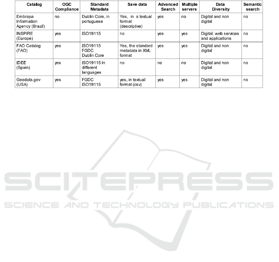
Table 1: Evaluated GIS Catalogs.
5 OPEN RESEARCH TOPICS
This section summarizes some open research issues
that we have identified as a result of the comparison
presented on subsection 4.2. This reflects what we ex-
pect to be the most important features to be supported
by catalogs, towards making the Geospatial Semantic
Web a reality.
• Search on Multiple Servers. We identify this as a
challenge because of the following: (1) some cat-
alogs presented bad performance, thus motivating
the need to develop or adopt better algorithms; (2)
some results were very difficult to interpret be-
cause of the language they use, making the data
useless. Hence, content description has to be also
in a well-known language; (3) some results were
dependent on available services. As many catalog
or data providers were offline, it was impossible
to get the data.
• Semantic Search. This is a central issue to be con-
sidered. The available catalogs do not provide this
kind of search, in spite of its usefulness when it
comes to geospatial data. A good survey of se-
mantic search approaches can be seen in (Man-
gold, 2007).
• Query Modification. Although this is part of the
previous item, it is also an important issue to be
considered by itself. Query modification in cata-
log search can help disambiguate search expres-
sions and enhance semantics.
• Adoption of Standards. This is a large ongoing
effort, focusing on interoperability of geospatial
data. The FAO Catalog and GOS are good exam-
ples for this issue. However, each one is based
on a different, but well known, geospatial stan-
dard. Hence, if their contents are to be combined,
one must develop translators from one to the other.
Common standards would avoid this kind of prob-
lem.
• Standard Interfaces. Once a user wants to search
for data in different catalogs, she has to identify
the available search options and what each field
means. We identify the design of common in-
terfaces as a promising research area. The devel-
opment of standardized services can also enhance
the use of the available catalogs.
6 CONCLUSIONS
Geospatial data available on the Web are very useful
to answer important questions for various domains,
such as emergency management, services and agroen-
vironmental planning. Geographic catalogs are orga-
nized as descriptive lists of metadata, which describe
existing geospatial data. Through the publishing of
these metadata, users are allowed to search for the de-
sired information to be used in their systems. How-
ever, this search is not a trivial task, subject to a wide
range of problems. In particular, in the context of the
Geospatial Semantic Web, there are two main issues
to be addressed: (1) how to perform semantic search,
seen as a means to reduce the ambiguity of terms? (2)
what should be done in order to have a huge semantic
geospatial data network?
This work discussed features that GIS catalogs
should present, focusing in the Geospatial Semantic
Web. These features are based on interoperability is-
sues, from the user viewpoint. We tested some exist-
ing and well known GIS catalogs, comparing them by
means of these criteria. Furthermore, we identified re-
search and development issues that are not addressed
by the tested catalogs, and that are very important for
THE GEOSPATIAL SEMANTIC WEB - Are GIS Catalogs prepared for This?
339

advanced Geospatial applications. Although many of
the existing catalogs are good, they are far from what
is needed to support Semantic Networks. Much effort
has to be directed to the use of ontologies on search
operations. Distributed search also represents a chal-
lenge, as this is not a controlled operation. Finally,
the adoption of standard interfaces could facilitate the
search for data. Initiatives such as OGC are doing a
good work in this direction. However there are still
gaps to be filled.
ACKNOWLEDGEMENTS
We would like to thank Embrapa, FAPESP, Virtual
Institute FAPESP-Microsoft (eFarms project), CNPq
and CAPES for the financial support for this work.
REFERENCES
Berners-Lee, T., Hendler, J., and Lassila, O. (2001). The
Semantic Web. Scientific American, pages 34–43.
Borges, K. A. V., Laender, A. H. F., Medeiros, C. B., and
C. A. Davis, J. (2007). Discovering geographic loca-
tions in web pages using urban addresses. In GIR ’07:
Proceedings of the 4th ACM workshop on Geograph-
ical information retrieval, pages 31–36, USA. ACM.
Egenhofer, M. J. (2002). Toward the semantic geospatial
web. In Proc. of the ACM GIS02, pages 1–4.
ESRI (2003). Implementing a metadata catalog portal in a
GIS network. Technical report, ESRI.
FAO (2008). FAO - GeoNetwork.
http://www.fao.org/geonetwork/srv/en/main.home.
FGDC (1998). FGDC-STD-001-1998. Content Standard
for Digital Geospatial Metadata. Washington, D.C.
ISO (2008). ISO 19115:2003 Geographic in-
formation – Metadata. ISO. Available
on:<http://www.iso.org/iso/home.htm>.
Jones, C. B., Abdelmoty, A. I., and Fu, G. (2003). Maintain-
ing ontologies for geographical information retrieval
on the web. In OTM Confederated International Con-
ferences - CoopIS, DOA, and OOBASE, pages 934–
951.
Klien, E., Einspanier, U., Lutz, M., and Hbner, S. (2004).
An architecture for ontology-based discovery and re-
trieval of geographic information. In 7th AGILE Con-
ference on Geographic Information Science, Herak-
lion, Greece. Parallel Session 3.1– Semantics I.
Larson, J., Siliceo, M., Silva, M., Klien, E., and Schade,
S. (2006). Are geospatial catalogues reaching their
goals? In 9th AGILE Conference on Geographic In-
formation Science - Poster, Visegrd, Hungria.
Mac
´
ario, C. G. N. and Medeiros, C. B. (2008). A framework
for semantic annotation of geospatial data for agricul-
ture. Int. J. Metadata, Semantics and Ontology - Spe-
cial Issue on ”Agricultural Metadata and Semantics”.
Accepted for publication.
Mac
´
ario, C. G. N., Medeiros, C. B., and Senra, R. D. A.
(2007). The webmaps project: challenges and results
(in portuguese). In IX Brazilian Symposium on GeoIn-
formatics - Geoinfo 2007, Brazil.
Mangold, C. (2007). A survey and classification of semantic
search approaches. Int. J. Metadata, Semantics and
Ontology, 2:23–34.
Nogueras-Iso, J., Zarazaga-Soria, F., Bjar, R., lvarez, P. .,
and Muro-Med, P. (2005). OGC catalog services: a
key element for the development of spatial data in-
frastructure. Computers & Geosciences, 31:199–209.
OCG (2006). CSW 2.0 FGDC application profile. Technical
Report OGC 06-129r1.
Shadbolt, N., Berners-Lee, T., and Hall, W. (2006). The
semantic web revisited. IEEE Intelligent Systems,
21(3):96–101.
Silva, H. (2008). MIG - Metadata for Geographic Informa-
tion –Introduction to ISO 19115 standard. Portuguese
Geographic Institute, Portugal. (in portuguese).
Souza, M. I. F., Santos, A. D., Moura, M. F., and Alves,
M. D. R. (2006). Embrapa information agency: an
application for information organizing and knowledge
management. In II Digital Libraries Workshop, pages
51–56, Brazil. (in portuguese).
Weibel, S., Godby, J., Miller, E., and Daniel, R.
(1995). OCLC/NCSA Metadata Workshop Re-
port. Web site http://www.oclc.org:5046/oclc/re-
search/conferences/metadata/
dublin
core report.html.
WEBIST 2009 - 5th International Conference on Web Information Systems and Technologies
340
