
A New Model Proposal for Integrated Satellite Constellation
Scheduling within a Planning Horizon given Operational Constraints
M. J. Pinto
1,2,4
, A. I. Barros
2
, R. Noomen
3
, P. H. A. J. M. van Gelder
4
and T. Lamballais Tessensohn
2
1
Geointelligence Division, Institute of Advanced Studies (IEAv), São José dos Campos, Brazil
2
Defence and Security, TNO, The Hague, The Netherlands
3
Faculty of Aerospace Engineering, Delft University of Technology, Delft, The Netherlands
4
Faculty of Technology, Policy and Management, Delft University of Technology, Delft, The Netherlands
Keywords: Scheduling, Satellite Constellation, Optimization Model, Operational Scenarios, Remote Sensing.
Abstract: The operational use of satellite systems has been increasing due to technological advances and the reduced
costs of satellites and their launching. As such it has become more relevant to determine how to better use
these new capabilities which is reflected in an increase in application studies in this area. This work focuses
on the problem of developing the scheduling of a constellation of satellites and associated ground stations to
monitor different types of locations (targets) with different priorities for a given planning horizon. In order
to address this problem we will propose a new model that considers explicitly the operational requirements
of Brazilian relevant scenarios for a given planning horizon and target priority list. The methodology to be
developed to solve this model will also be discussed.
1 INTRODUCTION
The rapid rate of technological advances in the area
of spaceflight and sensors combined with the
reduced costs of satellites and their launch yield
potential for applications in many areas like
navigation, communication, weather forecasting, and
also defense, safety and security, e.g. detecting oil
spilling, monitoring borders, etc. (IPIECA, 2006;
Brekke and Solberg, 2005; Gagne, 2017). As such
there is an increasing need for support during the
acquisition phase and planning of the use of these
new technologies.
As Brazil is in an emerging stage in terms of
management and development of satellite systems
technologies, there is a need for research focusing on
this context seeking a better management of satellite
services and products to increase the autonomy and
sovereignty of the country. Remote sensing using
satellites to acquire information on given areas of
the Earth´s surface are particularly interesting given
Brazil´s vast territory of more than 8.5 million
square kilometers. In order to contribute to this
challenge, this work focuses on the development of a
realistic optimization model that, given a planning
horizon and the specifications of different
satellites/sensors, can support the decision making
process on the best planning to monitor different
types of targets (high and low priority ones) taking
the mission requirements into account in a Brazilian
context.
As the mission requirements determine the type
of satellites/sensors that should be used, it is
important to define scenarios with logical
requirements. Brazil is confronted with several
environmental and security issues like drought,
deforestation, floods, landslides, dam ruptures, oil
spilling along the coast, border monitoring issues,
etc. For some of these situations satellite remote
sensing is an interesting option as sensors on-board
of such satellites can scan vast areas during day and
night and download this data to ground stations for
further processing and usage. However, the satellite
orbit and characteristics of the on-board sensor as
well as the location of the ground stations yield
limitations on the number of times and the duration
that a given area can be scanned by a particular
satellite and the time at which the collected
information can be downloaded to the ground
station. In this paper we will consider mostly
scenarios for which, regular monitoring can increase
the situation awareness and enable both early
detection of disasters and/or mitigation actions, like:
312
Pinto, M., Barros, A., Noomen, R., Gelder, P. and Tessensohn, T.
A New Model Proposal for Integrated Satellite Constellation Scheduling within a Planning Horizon given Operational Constraints.
DOI: 10.5220/0006655003120319
In Proceedings of the 7th International Conference on Operations Research and Enterprise Systems (ICORES 2018), pages 312-319
ISBN: 978-989-758-285-1
Copyright © 2018 by SCITEPRESS – Science and Technology Publications, Lda. All rights reserved

Deforestation in the Amazon: a very extensive
inland region of difficult access that is often
victim of deforestation attempts. The detection of
small areas of deforestation at an early stage will
permit authorities to take mitigation measures to
contain this deforestation.
Oil spilling along the extensive Brazilian coast
line: the extraction and transport of oil in this
vast area, which lies adjacent to some natural
reserves, poses environmental challenges. It is of
the utmost importance to detect oil spilling at an
early stage to contain any environmental disaster.
Monitoring Brazil’s border: this border
incorporates parts of the world’s largest
rainforest, which are difficult to access.
Therefore remote sensing of this vast area is
required in order to identify activities like the
construction of alternative roads for smuggling
or transportation of drugs.
Figure 1 provides an idea of the location and area
extension of the scenarios described above, and the
positions of the Brazilian ground stations as well.
Figure 1: Brazilian scenarios information based on
Petrobrás (2007), Gagne (2017) and DPI (2017).
This paper is organized as follows. In Section 2,
we introduce the problem and provide a review of
related models proposed in recent literature. Next
the operational background on satellite remote
sensing as well as the MATLAB program that has
been developed to compute the satellite coverage is
described in Sections 3 and 4. This coverage will be
input to the optimization model that will be
discussed in Section 5. Section 6 presents further
research possibilities.
2 DATA ACQUISITION AND
DOWNLOAD SATELLITES
SCHEDULING PROBLEM
This section introduces the Data Acquisition and
Download Scheduling Satellite Problem (DADSSP)
and discusses related proposed models.
DADSSP considers the planning problem of
assigning a set of different data requests (targets)
with different values (priorities) to a constellation of
heterogeneous satellites and ground stations in such
a way that the value of the collected data is
maximized (as not all the targets might be
addressed), while dealing with time-windows
constraints and different operational restrictions.
DADSSP also takes mission requirements
constraints into account, like revisit time (the time
interval between successive observations of the
same target) and due time (the latest time for
reception at the ground station of the acquired new
imagery of the same target). This problem is related
to the heterogeneous fleet routing problem with time
window and capacities (Toth and Vigo, 2014).
Most of the existing literature takes only the
acquisition problem into account in a static (Sundar
et al., 2016) or dynamic way (Zhai et al., 2015; Niu
et al., 2015). Also literature can be found related to
the scheduling problem of downloading the acquired
imagery by a satellite constellation to several ground
stations (Marinelli et al., 2011). However, in this
paper we will focus on literature that addresses
problems similar to DADSSP (Wang and Reinelt,
2011; Wang et al., 2011; Kim and Chang, 2015).
These papers handle both the acquisition and the
download planning but report few or no details
about the data and do not devote attention to
operational constraints (related to orbit/sensors
characteristics like inclination, altitude, resolution,
etc) and/or to mission requirement constraints.
Wang and Reinelt (2011) consider the
acquisition and download planning aiming to
maximize the summed rewards of serviced requests
subject to acquisition/download constraints and
visibility time-windows constraints, taking transition
time between consecutive acquisitions/downloads
into account. The precedence of the acquisition and
the download of the same request and the capacity of
the satellite memory level are also modelled. Their
modelling approach has been tested considering
satellites from the First Chinese Environment
Monitoring Constellation and ground stations from
China, in a two-days planning horizon.
A New Model Proposal for Integrated Satellite Constellation Scheduling within a Planning Horizon given Operational Constraints
313

Wang and Reinelt (2011) randomly generated the
input and it is not clear how the satellite related data
was modelled. Wang et al., (2011) provided more
details about the satellite system and energy capacity
constraints are included in a nonlinear model. As
this model is not easy to apply in practice and since,
according to the author, the acquisition planning
plays a more decisive role than the download
planning, a priority-based heuristic with conflict-
avoidance and a decision support system based on
the model is provided. The methodology was tested
using the same set of satellites of Wang and Reinelt
(2011) but considering spot and/or polygon targets,
uniformly positioned inside and/or outside the
mainland of China. The target rewards were again
randomly generated. Their paper presents another
version model of DADSSP and takes into account
relevant space operational concepts like the sensor
agility (capability in both roll and pitch axes, i.e., it
can look to the left and to the right and image targets
ahead and behind). However, requirements like due
and revisit time are not considered in the model.
Kim and Chang (2015) also considered the
acquisition and download problem, but their
objective was to reduce the system response time
defined as the time between the image data request
and its final distribution (including on-orbit imaging,
download and image processing on Earth). A genetic
algorithm is proposed to solve the problem. The
paper shows that the mission planning using the
scheduler reduces the system response time. It also
shows that an increase in the number of satellites
decreases both the revisit time and the response time
yielding an increase of the overall mission cost.
Moreover, a higher number of satellites does not
result in a significant decrease in revisit time nor
response time. They considered a horizon planning
of two months and a 50 × 50 km arbitrarily selected
target area on the Korean Peninsula. Their paper
considers several details about the satellite system
but not in a generic way as only Synthetic Aperture
Radar (SAR) sensors are included in the
constellation; in particular, agile SAR sensors with
automatic change detection for abnormal activities,
strip map mode for a large coverage and, after,
spotlight mode for high resolution.
The above literature review has shown different
types of models (concerning associated variables,
constraints and/or objectives) and that the DADSSP
has not yet been tackled before. It also showed the
importance of deriving models that are operationally
relevant and that take into account the space
operations concept (orbit/sensors characteristics) and
the requirements of the scenario.
3 OPERATIONAL CONCEPTS
This section will summarize basic elements of the
concept: satellite orbits, imagery sensors and ground
stations.
3.1 Satellite Orbit
Satellite orbits depend largely on the altitude above
the Earth surface and can be categorized as
Geosynchronous Earth Orbits (GEO), Medium Earth
Orbits (MEO) and Low Earth Orbits (LEO).
GEO satellites orbit Earth at an altitude of about
35,800 km, and are known to cover about one-third
of the surface of Earth, which is a great advantage.
However, as a consequence of the large distances
involved, the resolution of remote-sensing pictures
taken from such a position is typically limited. LEO
satellites (at altitudes up to 1500 km) do offer
excellent resolutions, but their coverage area is
restricted, and because of the inherent motion of the
spacecraft with respect to Earth, they can observe
specific targets on Earth only with limited durations
(a so-called pass may take up to 15 minutes,
depending on altitude and other geometrical
aspects). Depending on the requirements of a
particular mission, a combination of GEO and LEO
satellites is used (Wertz and Larson, 1999).
3.2 Imagery Sensors
Two main categories of imagery sensors can be
identified: passive and active. Passive sensors
measure sunlight that is reflected by the targets or
radiation emitted by the target itself. Active sensors
have its own source radiation and its sensor
measures reflected energy. Examples of each sensor
with respective satellites (Reuner, 2017a) are:
a) Active: ASAR (ENVISAT); SAR (ERS-2,
RADARSAT-1 and RADARSAT-2).
b) Passive: OSA (IKONOS); ETM (LANDSAT-7).
The imagery collected by a given sensor is the result
of a combination of the area observed and the sensor
characteristics in terms of its spatial, temporal and
spectral resolutions. Spatial resolution specifies the
pixel size of satellite images covering the Earth
surface. Temporal resolution specifies the revisiting
frequency of a satellite for a specific location.
Spectral resolution specifies the number of spectral
bands in which the sensor can collect radiation and
its width that is related to the position of bands in the
electromagnetic spectrum (Reuner, 2017a).
In general, the field of view (FOV) and the
ICORES 2018 - 7th International Conference on Operations Research and Enterprise Systems
314

sensor altitude above the ground determine the size
of the imaged area (swath width). FOV describes the
opening angle of the sensor, as shown in Figure 2.
Figure 2: Illustration of FOV and sensor swath. Reuner
(2017b).
3.3 Ground Stations
Most satellites have a limited storage capacity and
therefore it is essential to download the information
collected to ground stations when possible (i.e.
within the associated visibility window).
The contact options depend on the relative
motion of the two elements involved: the ground
station (which is at a fixed position on Earth, and
which is rotating 360 degrees in a day), and the
satellite which is going about in its orbit around
Earth (for a LEO satellite, a full revolution takes
about 100 minutes or slightly more). Contact is
possible whenever the two players are in direct view
(starting with the handshake process), i.e. when the
satellite appears above the effective horizon of the
ground station. Ideally, this horizon could be the true
horizon at zero degrees elevation, but in practice the
viewing options will be limited by trees, buildings,
hills, etc., so a more realistic minimum elevation of
about 5
o
is required. The download capacity depends
on a large number of aspects, both at the satellite and
at the ground station such as broadcast power,
frequency of signal, size and shape of antenna, beam
width, size of picture (Wertz and Larson, 1999).
The Brazilian ground tracking system of INPE
(National Institute of Space Research) is named
Satellite Tracking and Control Centre (CRC) and is
composed of the Satellite Control Centre (SCC),
located in São José dos Campos, and two S-Band
ground stations located in Cuiabá and Alcântara
(Chiaradia et al., 2013), as shown in Figure 1.
4 OPTIMIZATION PROBLEM
INPUT
Before exploring the model for the DADSSP we will
first address how to derive the input for this model.
For this, a MATLAB program has been developed to
evaluate the coverage of a given satellite and
associated sensor and a more detailed description of
the scenarios will be presented to identify relevant
requirements.
4.1 Scenarios and Detection
Characteristics
This section will elaborate on the required input in
terms of the characteristics of the satellites and
sensors taking the scenarios requirements and their
detection characteristics into account.
4.1.1 Oil Spill Detection
Accidents at sea-based oil platforms can yield huge
environmental damage, as most of the Brazilian oil
reserves are in marine fields, in deep and ultra-deep
waters far away from the coastline. Since this
monitoring process needs to be done for a large area,
remote sensing offers a good option to uncover
possible oil spilling. When the surveillance area has
been reduced, other platforms can be deployed to
identify the polluter, the extent and the type of spill.
In order to distinguish a possible oil spilling the
following oil characteristics need to be considered
(Brekke and Solberg, 2005; IPIECA, 2006):
• absorbs solar radiation and re-emits a portion of
this energy as thermal energy;
• emits stronger microwave radiation than the
water and appears as bright objects on a dark sea
• at night, a thick spill can appear cooler than the
water since it releases heat quicker than its
surrounding water;
• can have strong surface-emissivity signatures.
As such, the detection of any oil spill will depend on
oil type, thickness of the spill, wind speed, sea
temperature and the target dimensions.
In terms of dimensions and locations we will
consider two Brazilian oil basins: Campos and
Santos Basins. Santos basin is the largest basin in
the country, with an area of more than 350,000 km
2
,
extending from Cabo Frio (RJ) to Florianópolis
(SC). Campos basin is the main area already
explored on the Brazilian coast, extending from
Vitória (ES) to Arraial do Cabo (RJ) with an area of
approximately 100,000 km
2
. Figure 1 provides an
idea of the Petrobrás Oil Basins location.
According to literature, this type of application
requires regular monitoring, preferably daily in order
to detect potential oil spills. The desirable spatial
resolution will depend on the needs of the mission.
For a general response, medium-to-high resolution
A New Model Proposal for Integrated Satellite Constellation Scheduling within a Planning Horizon given Operational Constraints
315

imagery will be required to distinguish different
slicks (IPIECA, 2006). SAR sensors are considered
as the best and most efficient satellite sensor for this
application (Brekke and Solberg, 2005).
4.1.2 Deforestation
The Amazon rainforest has been subject of
deforestation which is endangering this natural
reservoir. The Amazon covers an area of over 6.5
million square kilometers in the northern part of
South America that spreads across nine countries.
Brazil has 85% of this region (5.217.423 km²) which
occupies 61% of the national territory (see Figure 1).
According to Butler (2017) on average 15,000 km²
of the Amazon forest are deforested every year.
As the Amazon area is huge, dangerous and quite
inaccessible, remote sensing to monitor it offers an
efficient tool to provide early detection of
deforestation areas in order to be able to act and stop
the process. Deforestation detection requires the
following capabilities:
• monitoring a large area;
• detection of very small areas in a forest region;
• coping with cloudy and forested areas.
INPE in collaboration with the Ministry of the
Environment (MMA) and the Brazilian Institute of
Environment and Renewable Natural Resources
(IBAMA) uses DETER/PRODES systems to
monitor deforestation and forest degradation in the
Amazon. DETER uses data from the MODIS Terra
satellite sensor, with a 250 m spatial resolution that
makes it possible to detect deforestation polygons
with an area larger than 25 hectares. The high
revisiting time of MODIS of two days is used to
quickly inform deforestation to surveillance
authorities (INPE, 2012). PRODES monitors clear-
cut deforestation and has produced annual
deforestation rates for the region since 1988 (Global
Forest Watch, 2017). This system historically used
LANDSAT-5 images, but now is capable of
showing small clearings (larger than 6.25 hectares)
because it also incorporated imagery from
LANDSAT-7, LANDSAT-8, CBERS-2, CBERS-
2B, Resourcesat-1 and UK2-DMC. More
information (in Portuguese) about the
PRODES/DETER systems can be found on the
INPE website on Amazonia (INPE, 2017).
In this type of scenario both the spatial and the
temporal resolution are important because daily
information reduces the time to prevent the
deforestation and high resolution can be easier to
detect small-size deforestation areas. So our
constellation will contain the PRODES satellites
(LANDSAT-8, CBERS and UK2-DMC) and
SENTINEL. LANDSAT-8 and UK2-DMC have
good resolution and small revisit times and CBERS
is considered a Brazilian satellite because it was
born from a partnership between Brazil and China.
SENTINEL presents better resolution than the others
and could detect smaller areas in comparison to what
is now detected by Brazilian systems.
4.1.3 Illegal Border Activities
Brazil has a more than 6,500 km border with all
three major production sources of cocaine Colombia,
Bolivia and Peru, as shown in Figure 1. Remote
sensing provides an alternative to monitoring and
identifying drug smuggling activities along this large
area (which in some regions is quite inaccessible).
As intelligence reports indicate possible
transportation routes and border crossing points,
these areas can be monitored in order to collect high-
quality imagery. Moreover, by regularly comparing
imagery on border areas, it will be possible to
identify the opening of new smuggling routes.
The above suggests that a high-resolution
imagery and a regular revisit times should provide a
good view of what is happening on the ground and
improve the surveillance efficiency (SatCen, 2017).
4.2 Satellites Constellation
Considering satellites and sensor data available and
the requirements related to the detection
characteristics in each scenario, our constellation
(sensors and respective satellites) will be probably:
SAR (TERRASAR-X, SENTINEL 1, RADARSAT-
1 and RADARSAT-2), OLI+TIRS (LANDSAT-8),
DMC (UK-DMC2) and WFI (CBERS).
4.3 Satellite Coverage Modeling
The input for the optimization model will be derived
using a MATLAB program that computes for given
satellite/sensor parameters the target coverage over
different time periods.
A mathematical formulation is required to assess
the visibility options between a spacecraft and a
location on Earth (irrespective whether this is a
target or a ground station). Here, the satellite
position is described with respect to a uniformly
rotating Earth and a fixed location position. The
coverage model for the (circular) satellite orbit is
based on the so-called dual-axis description. A
summary of the essential expressions is given below,
full details can be found in Wertz (2009).
ICORES 2018 - 7th International Conference on Operations Research and Enterprise Systems
316
sin(
sc
) = sin(i) cos(
2,0
+ nt)
(1)
α
sc
=
1,0
-
E
t +
acos2
(2)
where t is the independent parameter time, which
samples the spacecraft (index sc) position with an
arbitrary step size (e.g. once every second). The
latitude (measured with respect to the equator) and
longitude of the instantaneous satellite position are
expressed by δ
sc
and α
sc
, respectively. Parameter i is
the inclination of the orbit, n its mean motion, and
ω
E
the rotational velocity of Earth. Parameters φ
1,0
and φ
2,0
are arbitrary initial values of the satellite
position and Earth orientation at the reference epoch,
respectively. H is the so-called hemisphere function,
needed to provide the proper four-quadrant answer
for the acos function (hence acos2, see Wertz, 2009).
Taking a location gs with position (δ
gs
, α
gs
) as an
arbitrary target for contact, the distance D between
the satellite and this target can be obtained from:
D
2
= R
2
+ a
2
- 2Ra[sin(
sc
)sin(
gs
) +
cos(
sc
)cos(
gs
)cos(α
sc
- α
gs
)]
(3)
where R is the Earth radius, and a the semi-major
axis of the satellite orbit.
Knowing D, one can readily determine the
elevation angle ε. This is the angle with respect to
the local horizon with which the satellite can be
observed from the target (for ε equal to 90°, the
satellite is at zenith, i.e. directly above the target,
and for ε equal to 0° it is exactly on the horizon).
(4)
where
is the angle between the direction to the
satellite and to the target, as seen from the center of
Earth.
A direct link between the satellite and the target
is possible when the elevation is above a certain
minimum threshold (for communication with the
station, a representative value for ε
min
is 5°, whereas
for remote-sensing observations larger values are
typically required). When ε is negative, the satellite
is below the horizon as seen from the ground
component and it is invisible, obviously.
Basically, the coverage model uses the input:
• Satellite/sensor parameters: altitude; inclination;
spatial, temporal and spectral resolution; swath
width; field of view (FOV)
• horizon planning (time frame)
• target parameters: location; type (point or area)
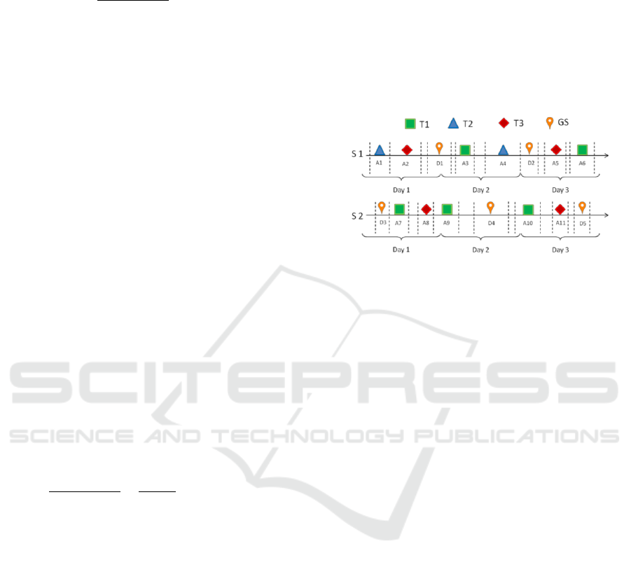
Working our way through (1)-(4) for a series of
time-steps t will provide the time-window of contact
opportunities between the satellite and one
target/ground station. The resulting time-windows
can be represented in a coverage histogram for ease
of interpretation, as shown in Figure 3. For a 3-days
horizon planning, three targets (T1, T2, T3), two
satellites (S1, S2) and one ground station (GS), 16
time-windows are derived: 11 acquisition time-
windows (A1 to A11) and 5 download time-
windows (D1 to D5).
Figure 3: Coverage histogram showing time-windows.
This coverage histogram and the scenario
requirements will define the input to the
optimization model. For instance, if satellite S1 has
a spatial resolution of 50 m and the requirement of
the target T2 is at most 30 m, then the acquisition
time-windows (A1 and A4) will not be considered as
input for the optimization model.
Results for the MATLAB analysis specifying the
Brazilian scenarios requirements in interaction with
required decision makers will be presented in a
follow-up paper.
5 OPTIMIZATION MODEL
We formulate the DADSSP as follows. Let H be the
planning horizon; the set of targets;
the
priority of target i; the set of heterogeneous
satellites in the constellation; S
i
the set of satellites
that can acquire target ; G the set of ground
stations; G
j
the set of ground stations that satellite j
has a visibility contact with;
the set of
acquisition time-windows wherein target i can be
acquired during the planning horizon H by satellite
;
the set of download time-windows wherein
the acquired data by satellite can be downloaded to
the ground station during the planning horizon H.
We are assuming that for a satellite its
acquisition/download time-windows do not overlap,
as the satellite will have to dedicate its time to a
single activity. Furthermore, let
be the start
and the end time of t-th acquisition time-window
A New Model Proposal for Integrated Satellite Constellation Scheduling within a Planning Horizon given Operational Constraints
317

and
the start and the end time of d-th
download time-window (
);
the required revisit time of target i (which implies
that in the given planning horizon H the target i will
be revisited at most
,
);
the required due time for the k-th download of
target i data In order to address the satellite
processing time capacity, let
be the volume of
data of the target i (in MB);
the acquisition
processing time of satellite j (in MB/sec);
the
download processing time of satellite j to the ground
station g (in MB/sec); C
j
the maximum processing
time capacity of satellite j during the planning
horizon H. Assuming that acquisition and download
of target data depends mostly on the data size, the
satellite acquisition and download processing time
as well as of the ground station processing time, the
acquisition and download time will be defined,
respectively, as
and
.
Consider the following decision variables:
indicates whether satellite j will be
used for the k-th acquisition of target i in the
acquisition time-window t;
indicates
if satellite j will download the k-th data acquired on
target i to the ground station g in the time-window d.
We will also define the variables
as the
start time of the k-th acquisition of target i by
satellite j;
as the start time of the k-th
download of target i by satellite j to ground station g.
(5)
s.t.:
(6)
(7)
(8)
(9)
(10)
(11)
(12)
(13)
The objective of DADSSP (5) is to maximize
the sum of the priorities of the target requests for
which all the required data was collected and
downloaded. Constraints (6) ensure that each target
request will be addressed at most once (by one
satellite and in one acquisition time-window). These
constraints also ensure that the target request is
completed only if the target data has been acquired
and downloaded to the ground station. Constraints
(7) enforce that targets that need to be revisited will
either be fully revisited or not at all. Constraints (8)
and (9) guarantee that the full acquisition and
download time required needs to fall within the
respective time-windows. Constraints (10) ensure
that for the targets that need to be revisited the
revisit time is respected. Constraints (11) ensure that
the acquired target data will be downloaded before
the required due time. Constraints (12) enforce the
acquisition/download precedence, i.e., the target data
can only be downloaded to a ground station if it was
fully acquired before by the same satellite. Finally,
Constraints (13) ensure that the satellite total
processing time will not exceed the satellite capacity
in the planning horizon.
To the best of our knowledge, revisit time and
due time have not yet been considered in the
literature. As these operational time scenario
requirements are extremely important in practice we
believe that they need to be addressed in order to
derive a model that can work in practice.
6 FINAL REMARKS
This paper proposes a new mathematical model to
DADSSP to find an optimal planning to acquire
different target data with different priorities taking
ICORES 2018 - 7th International Conference on Operations Research and Enterprise Systems
318

into account several operational constraints. Some of
these have not been addressed in literature before
but are required to realistically model mission
requirements. The model can be tackled with
optimization tools. Given its complexity heuristic
approaches should also be explored.
Further research also includes the extension of
the proposed model to consider polygon areas and to
model other constraints such as agility, storage
capacity and inherent uncertainties in the scenario.
Finally, if the considered satellite constellation
does not fulfill the scenario requirements it is
important to determine the best orbit/sensor
parameters to fill the identified gaps. The result is
expected to help Brazilian decision makers in future
acquisitions.
ACKNOWLEDGEMENTS
The authors would like to thank Harm-Pieter Gijsen
and Travis J. Pond for their collaboration in
developing the MATLAB program so far.
REFERENCES
DPI. AMBDATA: Administrative Units. In:
http://www.dpi.inpe.br/Ambdata/English/adm_units.p
hp. Accessed: September 2017.
Brekke, C., Solberg, A. H. S. Oil spill detection by
satellite remote sensing. Remote sensing of
environment, 95, 2005, p. 1-13.
Butler, R. Calculating deforestation figures for the
Amazon. 2017. In: http://rainforests.mongabay.
com/amazon/deforestation_calculations.html.
Accessed: August 2017.
Chiaradia, A. P. M, Kuga, H. K., Masago, B. Y. P. L.Short
arcs orbit determination using GPS. 11
th
International
Conference on Vibration Problems, Lisbon, Portugal,
September 2013.
Gagne, D., Lucrative Cocaine Trade Fuels Gang Presence
in Brazil's Amazon, 2017. In:
http://www.insightcrime.org/news-briefs/lucrative-
cocaine-trade-fuels-gang-presence-brazil-amazon.
Accessed: August 2017.
Global Forest Watch. Open data. 2017. In:
http://data.globalforestwatch.org/datasets/4160f715e12
d46a98c989bdbe7e5f4d6_1. Accessed: August 2017.
INPE. INPE releases DETER outcomes. 2012. In:
http://www.inpe.br/ingles/news/news.php?Cod_Notici
a=343. Accessed: August 2017.
INPE. National Institute for Space Research. 2017. In:
http://www.inpe.br/ingles/. Accessed: August 2017.
IPIECA. Satellite remote sensing of oil spills at sea. Good
practice guidelines for the application of satellite
remote sensing during oil spill response operations.
2016. In: http://www.oilspillresponseproject.org/wp-
content/uploads/2017/01/Satellite_remote_sensing_20
16.pdf. Accessed: August 2017.
Kim, H. and Chang, Y. K. Mission scheduling
optimization of SAR satellite constellation for
minimizing system response time. Aerospace Science
and Technology, v. 40, p. 17-32, 2015.
Marinelli, F., Nocella, S., Rossi, F. and Smriglio, S. A
Lagrangian heuristic for satellite range scheduling
with resource constraints. Computers & Operations
Research, v. 40, p. 1572-1583, 2011.
Niu, X., Tang, H., Wu, L., Deng, R, Zhai, X. Imaging-
duration embedded dynamic scheduling of Earth
observation satellites for emergent events.
Mathematical Problems in Engineering, v. 2015, 31
pages, 2015.
Petrobrás. Basin. 2017. In: http://www.petrobras.com.br/
en/our-activities/main-operations/basins/. Accessed:
August 2017.
Reuner, R. Introdution to Remote Sensing: Satellites and
Resolution. 2017a. In: http://lms.seos-
project.eu/learning_modules/remotesensing/remotesen
sing-c00-p01.html. Accessed: August 2017.
Reuner, R. Manine Pollution: Supplement 3.6: MERIS.
2017b. In: http://www.seos-project.eu/modules/
marinepollution/marinepollution-c03-s06-p01.html.
Accessed: August 2017.
SatCen. General crime and security surveillance. 2017. In:
https://www.satcen.europa.eu/services/general_crime_
and_security_surveillance. Accessed: September 2017.
Sundar, K., Qin, J., Rathinam, S., Ntaimo, L., Darbha, S.
and Valicka, C. Algorithms for a satellite constellation
scheduling problem. In: 2016 IEEE International
Conference on Automation Science and Engineering
(CASE), TX, USA, August 21-24, p. 373-378, 2016.
Toth, P., Vigo, D, eds. Vehicle routing: problems,
methods, and applications. Society for Industrial and
Applied Mathematics, 2
nd.
Edition, 2014.
Wang, P. and Reinelt, G. Solving the Earth Observing
Satellite Constellation Scheduling Problem by Branch-
and-Price. Operations Research Proceedings 2010.
Springer, Berlin, Heidelberg, p. 491-496, 2011.
Wang, P., Reinelt, G., Gao, P. and Tan, Y. A model, a
heuristic and a decision support system to solve the
scheduling problem of an earth observing satellite
constellation, Computers & Industrial Engineering, V.
61, p. 322-335, 2011.
Wertz, J. R. Orbit & Constellation, Design &
Management. Space Technology Library.
Microcosm/Kluwer, 2
nd
print, 2009. 968 pages.
Wertz, J. R. and Larson, W. J. Space mission analysis and
design. Space Technology Library. 3
rd
printa, 1999.
976 pages.
Zhai, X., Niu, X., Tang, H., Wu, L. and Shen, Y. Robust
satellite scheduling approach for dynamic emergency
tasks. Mathematical Problems in Engineering, v.
2015, 20 pages, 2015.
A New Model Proposal for Integrated Satellite Constellation Scheduling within a Planning Horizon given Operational Constraints
319
