
GeoSPARQL Query Tool
A Geospatial Semantic Web Visual Query Tool
Ralph Grove
1
, James Wilson
2
, Dave Kolas
3
and Nancy Wiegand
4
1
Department of Computer Science, James Madison University, Harrisonburg, Virginia, U.S.A.
2
Department of Integrated Science and Technology, James Madison University, Harrisonburg, Virginia, U.S.A.
3
Raytheon BBN Technologies, Columbia, Maryland, U.S.A.
4
Space Science and Engineering Center, University of Wisconsin, Madison, Wisconsin, U.S.A.
Keywords: Semantic Web, Geographic Information Systems, GeoSPARQL, SPARQL, RDF.
Abstract: As geospatial data are becoming more widely used through mobile devices and location sensitive
applications, the potential value of linked open geospatial data in particular has grown, and a foundation is
being developed for the Semantic Geospatial Web. Protocols such as GeoSPARQL and stSPARQL extend
SPARQL in order to take advantage of spatial relationships inherent in geospatial data. This paper presents
GeoQuery, a graphical geospatial query tool that is based on Semantic Web technologies. GeoQuery
presents a map-based user interface to geospatial search functions and geospatial operators. Rather than
using a proprietary geospatial database, GeoQuery enables queries against any GeoSPARQL endpoint by
translating queries expressed via its graphical user interface into GeoSPARQL queries, allowing geographic
information scientists and other Web users to query linked data without knowing GeoSPARQL syntax.
1 INTRODUCTION
The Semantic Web has the potential to greatly
increase the usability of publicly available data by
allowing access to open data sets in linked format
over the Web. W3C standards such as RDF (Manola
2004) and SPARQL (Prud’hommeaux, 2008) enable
standard access to data stored in triple stores that are
accessible over the Web at SPARQL endpoints. The
Linked Open Data (Bizer, 2009) movement adds
best practices for publishing data in order to
maximize availability and usability.
As geospatial data are becoming more widely
used through mobile devices and location sensitive
applications, the potential value of linked open
geospatial data in particular has grown, and a
foundation is being developed for the Semantic
Geospatial Web (Egenhofer, 2002). Protocols such
as GeoSPARQL (Perry, 2010) and stSPARQL
(Kyzirakos, 2012) extend SPARQL, the standard
RDF Semantic Web query language, in order to take
advantage of spatial relationships inherent in
geospatial data.
In this paper we present the GeoSPARQL Query
Tool (GeoQuery)
1
, a graphical geospatial query tool
that is based on Semantic Web technologies.
GeoQuery translates queries expressed through its
graphical user interface into GeoSPARQL queries,
which can then be executed against any
GeoSPARQL endpoint. With GeoQuery, geographic
information scientists can query linked data and see
map output without knowing GeoSPARQL syntax.
1.1 Motivation
The availability of linked open geospatial data and
the Semantic Web will offer the potential for
enhancing the value of geospatial data to the user in
several ways.
Data Search and Discovery: Semantic Web
protocols could be used to dynamically discover
and examine geospatial datasets over the Web, so
that newly created or revised datasets will be of
immediate value. The geospatial features of
GeoSPARQL could also allow spatial operations
to be incorporated into queries over metadata
contained in catalogs of available open data during
___________________________________________________________________________________
1
http://geoquery.cs.jmu.edu
33
Grove R., Wilson J., Kolas D. and Wiegand N..
GeoSPARQL Query Tool - A Geospatial Semantic Web Visual Query Tool.
DOI: 10.5220/0004797800330040
In Proceedings of the 10th International Conference on Web Information Systems and Technologies (WEBIST-2014), pages 33-40
ISBN: 978-989-758-024-6
Copyright
c
2014 SCITEPRESS (Science and Technology Publications, Lda.)

a search.
Integration of Data Sets: SPARQL provides the
ability to integrate data services within queries, so
that a user can perform logical queries of data from
multiple servers without regard to the details of
accessing multiple datasets and their respective
formats. One query, for example, might perform
spatial operations on data obtained from an open
map service, a public repository, and a corporate
data store.
Potential Applications of Semantic Web
Technologies: Beyond direct geospatial queries
(e.g., show me what public buildings exist with the
bounds of this city), techniques associated with the
Semantic Web such as ontological reasoning and
machine intelligence offer the potential for smarter
user interfaces that can anticipate queries and
integrate geospatial reasoning into emerging
technologies such as automated vehicles and
location aware phones.
The last ten years have seen tremendous growth
in the development and utilization of the Internet in
Geographic Information Systems (GIS). This growth
is taking place in standard desktop software that is
able to access geospatial data, maps, and
geoprocessing services through the Internet, as well
as web-based frontends to these same Internet based
resources.
Currently, geospatial data are just starting to be
represented in RDF (e.g., Varanka, 2012, and work
by the Ordnance Survey), and the full potential of
geospatial data available over the Web has yet to be
realized. Open standards such as those developed by
the Open Geospatial Consortium (OGC)
2
have
played an important role in facilitating these
developments. Most of these developments have
been an evolution of existing GIS technologies, with
only minor explorations into semantic technologies.
The most successful developments have been in
simplifying the access to distributed environments,
allowing non-specialists to take advantage of
mapping on the Internet. The small forays into
geospatial semantics on the Internet have mostly
been useable only by experts.
Conventional GIS allow users to explore, via a
graphical user interface, datasets that are stored in
proprietary or specialized data storage formats.
Now, with linked data in RDF, the data
representation format is open and standard. The
GeoSPARQL query language is a new standard with
which anyone can pose queries to data over a
___________________________________________________________________________________
2
http://www.opengeospatial.org/
provided web-based endpoint. However, SPARQL
and GeoSPARQL queries are not easy to write
correctly without training. Prior attempts to
overcome the difficulty of learning SPARQL
include, for example, a visual SPARQL editor
(Collustra, 2013). It might also be possible to
approach this problem through a natural language
interface to GeoSPARQL queries. However, natural
language processing remains a difficult, not
completely solved problem.
GeoQuery is a first step towards developing a
universal query tool for the Geospatial Semantic
Web. GeoQuery demonstrates that it is feasible to
execute geospatial queries based upon the Semantic
Web infrastructure using a graphical user interface.
This ability is of value to geospatial professionals
who need access to the data but are not trained in
Semantic Web technologies. Because GeoSPARQL
queries are viewable in GeoQuery, users can also
learn about the GeoSPARQL language.
2 RELATED WORK
The Ordnance Survey in Great Britain pioneered
Semantic Web work for geospatial data, including
the use of linked data (e.g., The Linked Data Web,
2013) and the building of geospatial ontologies (e.g.,
Denaux et al., 2011). The Ordnance Survey held the
first Terra Cognita geospatial workshop at the 2006
International Semantic Web Conference (ISWC) to
add spatial data to the Semantic Web. The Spatial
Ontology Community of Practice (SOCoP), along
with others, have continued the series with the fifth
one (Terra Cognita, 2012) being held with ISWC
2012.
In the United States, the Geological Survey
(USGS) is doing work on linked data and ontologies
(Geospatial Semantics and Ontology, 2013),
including a recent workshop (Varanka, 2012). The
USGS has translated some of The National Map data
into RDF format. Transferring spatial data into RDF
is a new area that the authors are also working on.
Meanwhile, to handle nonspatial RDF data, leading
database companies, such as Oracle and DB2, have
added RDF storage and processing to their relational
database systems e.g., (Das et al., 2004, Ma et al.,
2008). Because query processing of geospatial data
in RDF is still new, Garbis et al. (2013) recently
developed a benchmark to judge the performance of
several RDF stores for geospatial querying. The
database community is also interested in temporal
aspects of the Semantic Web, and a bibliography has
WEBIST2014-InternationalConferenceonWebInformationSystemsandTechnologies
34

been compiled that also includes spatial references
(Grandi, 2012).
Koubarakis et al. (2012) delineate areas of
research for linked geospatial data, of which one
area is user interfaces. They pose questions as to
whether user interfaces should be based on natural
language or be graphical, what high level APIs
would ease rapid development, and whether
interfaces could be built using existing platforms
such as Google Maps, Bing Maps, or
OpenStreetMap. In our work, we developed a
graphical interface and used OpenStreetMap and
Web Map Service for map display.
Our work uses the GeoSPARQL model as an
extension to SPARQL. There is another spatial
extension to SPARQL, stSPARQL, which is
implemented in Strabon (Kyzirakos, 2012). Strabon
extends Sesame, which has the ability to have
PostGIS as a backend DBMS and spatial query
processor. stSPARQL and GeoSPARQL do not
overlap perfectly in functionality: stSPARQL
includes aggregate functions and update capabilities
(without which stSPARQL is a subset of
GeoSPARQL), while GeoSPARQL includes an
ontology and allows for topological relations as
triples. A query language in addition to SPARQL
and stSPARQL that incorporates spatial
considerations is SPOTL (SPO + Time and
Location) in the YAGO2 project (Hoffart et al.,
2012). Time and location of facts are represented
through reification.
3 SEMANTIC WEB
TECHNOLOGIES FOR
GEOSPATIAL DATA
Most early efforts to add geospatial data to the
Semantic Web focused on very simple geospatial
data, i.e., points represented by latitude and
longitude. The W3C Geo ontology is popular for
representing such points. Though this is sufficient
for many domains and use cases, more complicated
geospatial domains require the ability to use multiple
coordinate systems and to store polygons and other
shapes. This led to development of GeoSPARQL
and its support in Parliament (see section 3.2).
3.1 GeoSPARQL
GeoSPARQL provides a unifying vocabulary for
geospatial data on the Semantic Web. GeoSPARQL
has two key parts: a small ontology for representing
geospatial entities, and a set of query functions for
processing relationships between the geospatial
entities. The ontology is derived from well-used and
well-understood concepts from the OGC and uses
much of the same terminology as other OGC
standards. The ontology is intentionally small so
that it can be easily understood and easily attached
to an appropriate domain ontology.
There are two key classes in the GeoSPARQL
ontology: Feature and Geometry. A Feature is
simply any entity (physical or abstract) with some
spatial location. This could be a park, airport,
monument, restaurant, etc. A Geometry is any
geometric shape, such as a point, polygon, or line,
and is used as a representation of a feature’s spatial
location. A third class, SpatialObject, is a
superclass of both Feature and Geometry.
A Feature has only one primary property,
hasGeometry. This property links the Feature to a
Geometry that represents where it is in space. A
Feature can have multiple Geometries, in which case
it may specify one of these as the defaultGeometry
to be used for spatial reasoning.
A Geometry has a number of properties, but the
most important ones are those that relate the
Geometry to a concrete spatial representation.
These are asWKT and asGML, depending on
whether the representation is in Well Known Text
(WKT) (Open Geospatial Consortium, 2011) or
Geography Markup Language (GML)
3
respectively.
The properties point to an RDF literal with a data
type of wktLiteral or gmlLiteral. Within these
literals are the points that delineate the geometry: for
example, the corners of a polygon.
The general usage of this ontology is to attach it
to the ontology of the domain. If a domain ontology
includes classes with relevant geospatial locations,
those classes are declared subclasses of Feature. In
this way they inherit the hasGeometry property and
its link to the Geometry class.
The query functions in GeoSPARQL are used to
relate the Features and Geometries to one another.
The functions include binary topological
relationships, set combinations of Geometries (ex.
union, intersection), and other calculations such as
distance. When possible, GeoSPARQL provides
multiple sets of terminology for these functions. For
example, the topological relations can be expressed
in the terminology of the 9-intersection model
(Egenhofer, 1990), RCC-8 (Randell, 1992), or OGC
Simple Features (Open Geospatial Consortium,
2011). While implementations of GeoSPARQL do
___________________________________________________________________________________
3
http://www.opengeospatial.org/standards/gml
GeoSPARQLQueryTool-AGeospatialSemanticWebVisualQueryTool
35
not have to support all of these vocabularies, it is
expected that most will. The binary Boolean
topological relations can be expressed as either
functions in a FILTER clause or as triples between
SpatialObjects.
The following is an example of a GeoSPARQL
query, which looks for monuments within parks,
where both classes are subclasses of Feature. For
more detailed examples see the GeoSPARQL
specification (Perry, 2010) or (Battle, 2012). (The
prefix “geo:” in this example refers to
www.opengis.net/ont/geosparql, while the prefix
“ex:” refers to an arbitrary example domain.)
SELECT ?m ?p
WHERE{
?m a ex:Monument ;
geo:hasGeometry ?mgeo .
?p a ex:Park ;
geo:hasGeometry ?pgeo .
?mgeo geo:within ?pgeo .
}
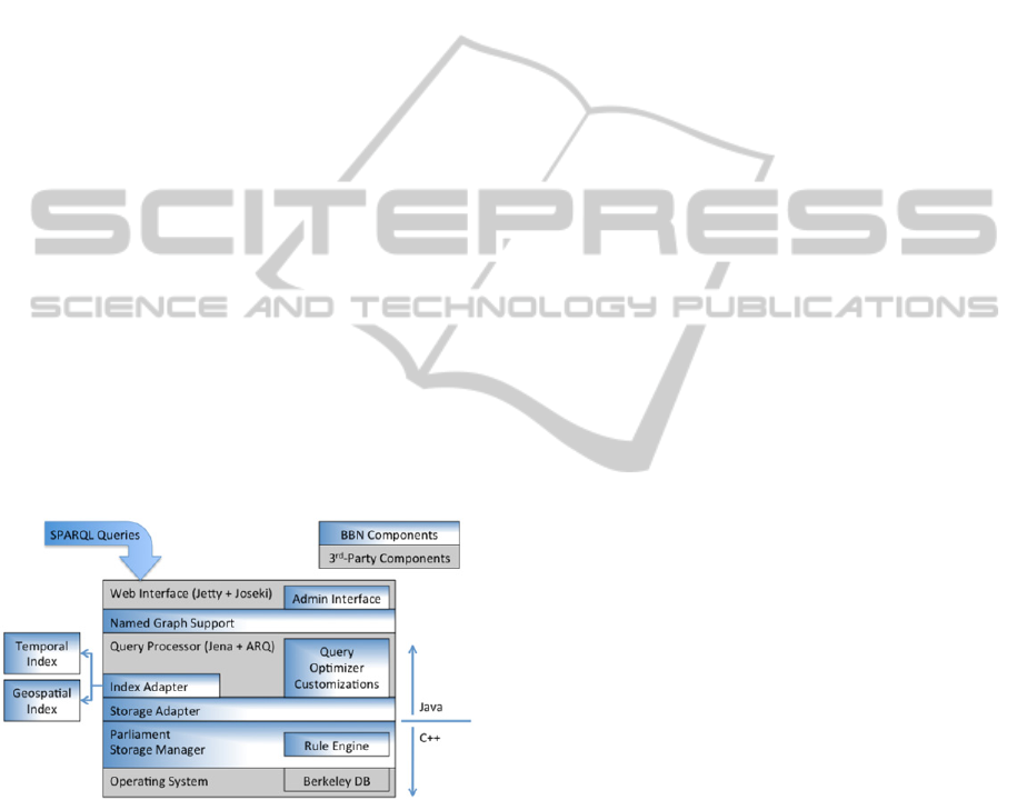
3.2 Parliament
Parliament
4
is an open-source RDF triple store
(Figure 1). The outer layers are based on the open-
source RDF toolkit Jena
5
, which connects to a novel
indexing scheme for RDF triples (Kolas 2009).
Parliament provides a SPARQL endpoint for storing
and querying RDF triples.
Figure 1: Parliament Architecture.
As the importance of the Geospatial Semantic Web
grew, Parliament added spatial and temporal
indexing. Initially this was a purely in-memory
index designed as a proof of concept. It used OWL-
Time
6
and an ontology based on GeoRSS
7
as the
vocabularies for indexing. More recently the indices
___________________________________________________________________________________
4
http://parliament.semwebcentral.org/
5
http://jena.apache.org/
6
http://www.w3.org/TR/owl-time/
7
http://www.georss.org
were updated to be persistent. The spatial index can
use either an R-tree implementation or an external
instance of Postgres. The temporal index uses
Berkeley DB. The result is the ability to store and
query spatial and temporal RDF efficiently. As the
GeoSPARQL standard matured, Parliament was
updated to include support for the standard.
4 GeoQuery
GeoQuery is being developed to provide GIS
professionals an easy way to explore geospatial
semantics in a familiar mapping interface, and to
provide the ability to see how the semantics queries
are actually built and executed.
The user interface is similar to many web-based
mapping sites, where the user can turn layers on and
off, and navigate around the map by panning and
zooming. The interface also includes the ability to
execute two separate queries using pick lists and text
boxes, and to perform spatial operations on the
results of the two queries. The onscreen areas for
performing these operations have separate colors,
and the results for each operation are displayed on
the map with the same color to make it easy to
identify the results for each operation.
Because one of the design goals of GeoQuery
was to help explain GeoSPARQL, the full text of
each GeoSPARQL query is saved and all of the
query text can be viewed at any time.
The GeoSPARQL endpoint we are using for
development is an instance of Parliament that has
been populated with vector data extracted from the
USGS National Map
8
. The data was extracted using
the boundaries of the Shenandoah River (Virginia,
USA) watershed, and was converted from an ESRI
Personal Geodatabase to .N3 files using a custom
tool developed by the USGS
9
.
4.1 Design and Operation
Development of GeoQuery began by establishing a
set of six general use cases that were gathered by
examining example queries from literature.
Development followed a prototyping process, the
starting point for which was a tool for visualizing
GeoSPARQL query results developed by the USGS.
The ultimate user interface was developed with the
___________________________________________________________________________________
8
See “Prodxucts and Services” at
http://nationalmap.gov/index.html
9
USGS NationalMap2RDF conversion tool:
http://cegis.usgs.gov/ontology_userguide.html
WEBIST2014-InternationalConferenceonWebInformationSystemsandTechnologies
36
intention of reproducing some controls and functions
commonly found in existing GIS software.
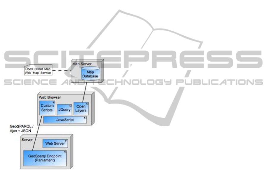
Architecturally, GeoQuery is a web application
that uses the web browser as its execution platform
(Figure 2). As such, it is written entirely in HTML
and JavaScript. The map display functionality is
based upon OpenLayers
10
, which provides a robust
API for obtaining, displaying, and manipulating map
tiles. JQuery provides a variety of coding shortcuts
that reduce the overall amount of custom JavaScript
required. The interface to the GeoSPARQL endpoint
is based on Ajax and JSON. All GeoSPARQL
queries are generated in JavaScript and then sent via
Ajax to the Parliament server. Responses are
returned in JSON format.
The current GeoSPARQL endpoint is built with
Parliament, but GeoQuery should be compatible
with any GeoSPARQL server.
Figure 2: GeoQuery Architecture.
At startup, GeoQuery launches a predefined
GeoSPARQL query to request map bounds (which
are pre-loaded into the endpoint server) in order to
select the initial map display. Other than this
initialization, the system is fully event-driven. Each
time the user launches a query or executes a spatial
operation, the request is translated into GeoSPARQL
and delivered via Ajax to the GeoSPARQL endpoint
server. Query results, which consist of sets of spatial
objects with WKT encoding, are returned as JSON
objects, which must be decoded in order to be
displayed on the map when appropriate. Some
queries also return textual results, which are
displayed in pop-up windows. No query
___________________________________________________________________________________
10
http://openlayers.org
optimization is performed in this version, but that
would be an obvious next step in development.
4.2 User Queries
The user interface includes a map with basic
navigation tools on the right side of the screen and
user options for interacting with the data on the left
side (Figure 3). The interface allows for two distinct
queries to be executed, and for a spatial operation to
be performed on the combined results.
For example, finding all of the schools that are
present in a particular county (using the USGS
National Map data) can be accomplished by defining
the two queries and then applying a spatial
operation.
First, to find all of the schools, the query can be
defined in the Feature 1 query section on the user
interface (Figure 3 - query area and results displayed
in orange). In the USGS data, the point locations for
different types of structures are stored in the class
called structPoint, with different types of structures
coded in a field called fType. Schools can be
selected by selecting the feature type of structPoint,
and the feature property fType with an fType value of
730 (Figure 3, Appendix: Query 1). Then, the
Feature 2 query area can be used to select a
particular county (query area and results displayed in
cyan). Shenandoah County can be selected by
choosing the feature type of countyOrEquivalent,
then selecting to search on the label “Shenandoah”
(Query 2). Invoking the Spatial Relationship tool
(selection area and results displayed in purple)
allows for any of the GeoSPARQL supported spatial
operations to be applied to the results of the two
searches, such as determining the schools that are
within Shenandoah County (Figure 4, Appendix:
Query 3).
Queries are created based on predefined patterns,
using terms selected by the user from those derived
from the data store. GeoQuery does not apply
heuristics or make inferences from input, rather it
responds in a straightforward way to user selections.
Terms used to describe features and their properties
are derived from the data store, and GeoQuery does
not interpret or modify them. These abilities could
be extensions to the tool in future versions.
Providing a complete interface to GeoSPARQL
was not a design goal of this project. The set of
query forms generated by GeoQuery is a small
subset of the (infinite) set of query forms that could
be generated in GeoSPARQL. Though more
complex query options could be added to GeoQuery
to extend the range of resulting queries, it is not
GeoSPARQLQueryTool-AGeospatialSemanticWebVisualQueryTool
37
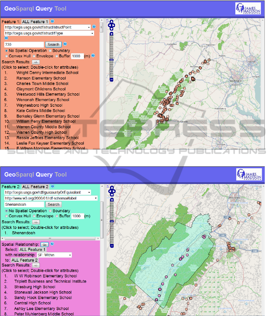
Figure 3: Schools.
Figure 4: Schools within Shenandoah County.
clear that completeness could be gained without
exposing the user to elements of GeoSPARQL
syntactic structure, which is counter to the design
goals. Instead, we have provided an interface to
support commonly used types of queries.
5 CONCLUSIONS
This work illustrates how a geospatial query tool can
be successfully implemented based on Semantic
WEBIST2014-InternationalConferenceonWebInformationSystemsandTechnologies
38

Web technologies such as RDF, SPARQL, and
GeoSPARQL. Users can effectively query an RDF
geospatial database over the Web, execute spatial
operators on the results, and then visualize the
results on a map in a familiar format, without
knowing a formal query language. This is a first step
towards bringing the value of the Semantic Web and
open data to geospatial data and users. GeoQuery is
an integral step in provided needed query access to
the Geospatial Semantic Web.
The current GeoQuery tool is an initial proof of
concept. The tool could be improved by replacing
USGS National Map URIs and codes with more
user-understandable synonyms. We used RDF data
directly from The National Map and did not re-code
it to be understandable by the general user. This is a
limitation of using data directly converted to RDF,
but adding definitions or links to ontologies is
beyond the scope of this project. The innovation of
our work is to take a new paradigm (RDF and
GeoSPARQL) and make the data and querying
accessible to any Web user using a graphical
interface.
Testing to improve the tool could include formal
user testing, testing of the tool against other
SPARQL endpoints, testing with multiple endpoints
simultaneously, and comparing its use against
conventional tools. Additional extensions of the tool
could include query optimization, the addition of
more complex query forms through additional user
interface options, and automatic clustering of results.
We are also working on methods to automate
converting general spatial data to RDF to make more
spatial data accessible and to further test the tool.
ACKNOWLEDGEMENTS
A This work was partially supported by the National
Science Foundation’s Office of Cyberinfrastructure
(OCI), INTEROP Grant No. 0955816.
Early versions of GeoQuery were based in part
on a prototype query tool developed by USGS
REFERENCES
Battle, R., Kolas, D., 2012. Enabling the Geospatial
Semantic Web with Parliament and GeoSPARQL,
Semantic Web Journal 3(4): 355-370.
Bizer, C., Heath, T., and Berners-Lee, T., 2009. Linked
Data – The Story So Far, International Journal on
Semantic Web and Information Systems, Special Issue
on Linked Data, 5:1–22.
Collustra, 2013. (Online). Available: http://tw.rpi.edu/
web/event/TWeD/2013/Fall/Collustra (30 Sep 2013).
Das, S., Chong, E. I., Eadon, G., Srinivasan, J., 2004.
Supporting Ontology-based Semantic Matching in
RDBMS, Proceedings of the 30
th
VLDB Conference,
Toronto, Canada, pp. 1054-1065, 2004.
Denaux, R., Dolbear, C., Hart, G., Dimitrova, V., and
Cohn, A., 2011. Supporting Domain Experts to
Construct Conceptual ontologies: A Holistic
Approach, Web Semantics: Science, Services and
Agents on the World Wide Web, 9 (2011), pp. 113-127.
Egenhofer, M. J., and Herring, J. R., 1990. Categorizing
binary topological relations between regions, lines,
and points in geographic databases. Technical report,
Department of Surveying Engineering, University of
Maine.
Egenhofer, M. J., 2002. Toward the semantic geospatial
web, Proceedings of the ACM GIS02, pp. 1-4.
Garbis, G., Kyzirakos, K., and Koubarakis, M., 2013.
Geographica: A Benchmark for Geospatial RDF
Stores, accepted at the 2013 International Semantic
Web Conference.
Geospatial Semantics and Ontology, 2013. Center for
Excellence in Geospatial Science, [Online], Available:
http://cegis.usgs.gov/ontology.html [15 Sep 2013].
Grandi, F., 2012. Introducing an Annotated Bibliography
on Temporal and Evolution Aspects in the Semantic
Web, SIGMOD Record, December 2012 (Vol. 41, No.
4), pp. 18-21, Available: http://www-
db.deis.unibo.it/~fgrandi/TWbib/TSWbib.html (15
Sep 2013).
Hoffart, J., Suchanek, F. M., Berberich, K., and Weikum,
G., 2012. YAGO2: A Spatially and Temporally
Enhanced Knowledge Base from Wikipedia (preprint),
(Online), Available: http://www.mpi-inf.mpg.de/yago-
naga/yago/publications/aij.pdf (29 Sep 2013).
Kolas, D., 2009. Supporting Spatial Semantics with
SPARQL, Transactions in GIS, Vol. 12, Issue s1, pp.
5-18, December 2008.
Koubarakis, M., Karpathiotakis, M., Kyzirakos, K.,
Nikolaou, C, and Sioutis, M., 2012. Data Models and
Query Languages for Linked Geospatial Data,
Reasoning Web 2012, LNCS 7487, T. Eiter and T.
Krennwallner (Eds.) pp. 220-328, 2012.
Kyzirakos, K., Karpathiotakis, M., and Koubarakis, M.,
2012. Strabon: A Semantic Geospatial DBMS,
Proceedings of the 11th International Semantic Web
Conference (ISWC 2012), Boston, USA, November
11th-15th.
The Linked Data Web, (Online), Available:
http://www.ordnancesurvey.co.uk/education-
research/research/linked-data-web.html (16 Sep 2013).
Ma, L., Wang, C., Lu, J., Cao, F., Pan, Y., Yu, Y., 2008.
Effective and Efficient Semantic Web Data
Management over DB2, Proceedings of the 2008
ACM SIGMOD International Conference on
Management of Data, pp. 1183-1194.
Manola, F., Miller, E. (Ed.s), 2004. RDF Primer, (Online),
Available: http://www.w3.org/TR/rdf-primer (25 Dec
2013).
GeoSPARQLQueryTool-AGeospatialSemanticWebVisualQueryTool
39

Open Geospatial Consortium, 2011. OpenGIS
Implementation Standard for Geographic information -
Simple feature access - Part 1: Common architecture,
(Online), Available: http://www.opengeospatial.org/
standards/sfa (25 Dec 2013).
Perry, M., Herring, J. (Eds.), 2010. OGC GeoSPARQL -
A Geographic Query Language for RDF Data, Open
Geospatial Consortium, (Online), Available:
http://www.opengis.net/doc/IS/geosparql/1.0 (16 Sep
2013).
Prud’hommeaux, E. ,Seaborne, A. (Eds.), 2008. SPARQL
Query Language for RDF, (Online), Available:
http://www.w3.org/TR/rdf-sparql-query (25 Dec
2013).
Randell, D. A., Cui, Z., and Cohn, A. G., 1992. A spatial
logic based on regions and connection. In Proceedings
of the 3rd International Conference on Knowledge
Representation and Reasoning.
Terra Cognita, 2012. (Online), Available:
http://iswc2012.semanticweb.org/workshops/TerraCog
nita.html (15 Sep 2013).
Varanka, D. (Ed.), 2012. Introduction to Geospatial
Semantics and Technology Workshop Handbook, 2012
University Consortium for Geographic Information
Science Symposium, (Online), Available:
http://pubs.usgs.gov/of/2012/1109/ (15 Sep 2013).
APPENDIX
Query 1: select structPoint with fType=730
PREFIX rdf: <http://www.w3.org/1999/02/22-rdf-syntax-ns#>
PREFIX rdfs: <http://www.w3.org/2000/01/rdf-schema#>
SELECT DISTINCT ?feature ?label
WHERE {
# Select features of the specified type:
?feature rdf:type <http://cegis.usgs.gov/rdf/struct/structPoint> .
?feature rdfs:label ?label .
# Filter features by property:
?feature <http://cegis.usgs.gov/rdf/struct/fType> ?obj .
FILTER( regex(str(?obj), "730", "i" ) ) .
# Eliminate the group of features ending in "/None"
FILTER(! regex(str(?feature), "/None$", "i" ) ) .
}
………..Not showing individual queries to obtain geometry and
map the features….
Query 2: Select & draw Shenandoah from
countyOrEquivalent
PREFIX rdf: <http://www.w3.org/1999/02/22-rdf-syntax-ns#>
PREFIX rdfs: <http://www.w3.org/2000/01/rdf-schema#>
SELECT DISTINCT ?feature ?label
WHERE {
# Select features of the specified type:
?feature rdf:type
<http://cegis.usgs.gov/rdf/gu/countyOrEquivalent> .
?feature rdfs:label ?label .
# Filter features by property:
?feature <http://www.w3.org/2000/01/rdf-schema#label> ?obj .
FILTER( regex(str(?obj), "Shenandoah", "i" ) ) .
# Eliminate the group of features ending in "/None"
FILTER(! regex(str(?feature), "/None$", "i" ) ) .
}
PREFIX geo: <http://www.opengis.net/ont/geosparql#>
SELECT ?wkt
WHERE {
<http://cegis.usgs.gov/rdf/gu/Features/1673918>
geo:hasGeometry ?g .
?g geo:asWKT ?wkt .
}
Query 3: Schools within Shenandoah County
PREFIX geo: <http://www.opengis.net/ont/geosparql#>
PREFIX geof: <http://www.opengis.net/def/function/geosparql/>
PREFIX rdf: <http://www.w3.org/1999/02/22-rdf-syntax-ns#>
PREFIX rdfs: <http://www.w3.org/2000/01/rdf-schema#>
PREFIX units: <http://www.opengis.net/def/uom/OGC/1.0/>
SELECT DISTINCT ?feature ?label
WHERE {
# Feature 1:
# Select features of the specified type:
?feature rdf:type <http://cegis.usgs.gov/rdf/struct/structPoint> .
?feature rdfs:label ?label .
# Filter features by property:
?feature <http://cegis.usgs.gov/rdf/struct/fType> ?obj1 .
FILTER( regex(str(?obj1), "730", "i" ) ) .
# Eliminate the group of features ending in "/None"
FILTER(! regex(str(?feature), "/None$", "i" ) ) .
?feature geo:hasGeometry ?g1 .
?g1 geo:asWKT ?wkt1 .
# Feature 2:
# Select features of the specified type:
?feature2 rdf:type
<http://cegis.usgs.gov/rdf/gu/countyOrEquivalent> .
# Filter features by property:
?feature2 <http://www.w3.org/2000/01/rdf-schema#label> ?obj2
.
FILTER( regex(str(?obj2), "Shenandoah", "i" ) ) .
# Eliminate the group of features ending in "/None"
FILTER(! regex(str(?feature2), "/None$", "i" ) ) .
?feature2 geo:hasGeometry ?g2 .
?g2 geo:asWKT ?wkt2 .
# spatial relationship
FILTER (geof:sfWithin(?wkt1, ?wkt2)) .
}
(Note: Some of the queries contain a filter term intended to
eliminate features ending in “/None”. These are features that have
incomplete definitions, an anomaly of the test dataset that was
used.)
WEBIST2014-InternationalConferenceonWebInformationSystemsandTechnologies
40
