
INDOOR NAVIGATION USING APPROXIMATE POSITIONS
Ory Chowaw-Liebman, Karl-Heinz Krempels
Janno von St
¨
ulpnagel and Christoph Terwelp
Informatik 4, Intelligent Distributed Systems Group
RWTH Aachen University, Aachen, Germany
Keywords:
Indoor navigation, Mobile computing, Device whispering, Context-based services.
Abstract:
Navigation aids have usually concentrated on the great outdoors, whether driving on highways or, more re-
cently, walking through cities. These systems use the Global Positioning System (GPS) for position infor-
mation. Indoor navigation cannot rely on GPS. In order to provide position information indoors, a technique
called device whispering was developed.
The following presents an indoor system currently being developed, which is suited to the imprecise position
information provided by device whispering.
1 INTRODUCTION
Computerized aids to navigation are the natural exten-
sion to printed maps. Since the advent of GPS, these
tools have become interactive, instead of being lim-
ited to providing precomputed routes with graphics.
The first systems where targeted at supporting vehicle
navigation. Early interactive devices used dedicated
hardware, but mobile phones are starting to be used
as alternative hardware.
This has in turn motivated navigation systems for
pedestrians, e.g. Qiro
1
or Nav4All
2
. Qiro actually
uses only the current cell as information, and only if
it is not ambiguous; users can manually input their
current position (see FAQ on Qiro’s web page). The
use of trilateration, or even multilateration could be
a possibility, but are computationally expensive, most
likely preventing a satisfactory user experience.
Further, tri- or multilateration based on neighbor
cells’ signal strengths have difficulty coping with the
various propagation effects present in cell based net-
works. For instance, reflection of radio waves often
allows a connection to the base station without a di-
rect line of sight - breaking the assumption lateration
techniques are based on. In case of indoor systems,
which is considered here, GPS cannot be used for po-
sitioning, because the radio waves used by the GPS
system do not propagate through roofs (or even dense
foliage). However, cell based networks in the form of
1
www.qiro.de
2
www.nav4all.com
wireless local area networks (WLAN) can be used for
positioning.
Currently, research considering indoor navigation
concentrates on improving the position data com-
puted. One possibility, used in (Ohlbach et al., 2006),
is fingerprinting, which provides detailed informa-
tion about local propagation effects. Another tech-
nique for indoor positioning named Device Whisper-
ing (Krempels and Krebs, 2008; Patzak, 2009), was
developed at the Department of Computer Science,
Informatik 4, of the RWTH Aachen. This method
is based on wireless local area networks, and trades
accuracy for speed. After a short description of the
technique, a navigation method is presented, which
is currently being developed as a real life application
based on whispering.
2 DEVICE WHISPERING
The main idea of the Device Whispering technique
is to reduce the access points considered for posi-
tion estimation. This is done by controlling the trans-
mitting power WLAN interface: The device is set to
minimum power, then queries access points for man-
agement information. The closest access point is de-
fined as the one answering to the request with the least
amount of transmission power used, which is the min-
imum information possible.
Access points can be tagged with positions, and
if multiple access points are available these tags can
168
Chowaw-Liebman O., Krempels K., von Stülpnagel J. and Terwelp C. (2009).
INDOOR NAVIGATION USING APPROXIMATE POSITIONS.
In Proceedings of the International Conference on Wireless Information Networks and Systems, pages 168-171
DOI: 10.5220/0002189301680171
Copyright
c
SciTePress
be used to approximate the current position some-
what more precisely than just giving the closest ac-
cess point. Various caveats are discussed in (Patzak,
2009), but this work will assume only knowledge of
the closest access point. The whispering method is
also robust against signal multi-path propagation and
power oscillations or automated adaption of access
points’ transmitting power.
Since the method is based on indoor infrastruc-
ture, reception should not be a problem, assuming ex-
isting infrastructure. But WLAN for Internet access
is more and more provided as a service to guests.
The method’s lack of precision makes it necessary
to use a novel approach, as current solutions assume
precise information. One such approach is presented
here, which is based on a sectorization of the map
based on the positions of the access points.
3 MAP GENERATION AND
REPRESENTATION
The whispering technique defines a mapping from a
point in space to the closest element in a set of spe-
cial points, the access points. This type of mapping,
known as Voronoi Diagrams, is an important concept
in computational geometry (Aurenhammer and Klein,
2000; Aurenhammer, 1991). Efficient algorithms to
compute the voronoi diagram for a set of points ex-
ist, see (Aurenhammer and Klein, 2000; Barber and
Dobkin, 1996). Thus, a natural, though idealized, sec-
torization of a floor plan can be generated automati-
cally by calculating the voronoi diagram of the access
points, and clipping the resulting sectors to the floor
plan.
Based on the assumption that Whispering acts as
a filter against propagation effects, such an idealized
sectorization should be sufficient. Technically this
idealization can be reduced by using a so called ap-
proximate Voronoi Diagram, which has fuzzy edges.
Instead, the system adds way-points on or close to
edges (in the next sector), to lead the user out of am-
biguous areas. 4 discusses how way-point instruc-
tions are communicated to the user.
The actual map used for navigation operates on
a graphs of sectors with edges connecting adjacent
sectors. Features of the geometry are positioned in-
side the containing sectors. These can be Targets (e.g.
shops or cafs), Landmarks (e.g. statues or fountains,
see 4.1) or connective features like stairs or elevators.
Connective features are associated with edges con-
necting locations not connected by normal sectors.
Thus map representation is supplied to client de-
vices by a local server, which can be contacted using
the WLAN infrastructure required for positioning.
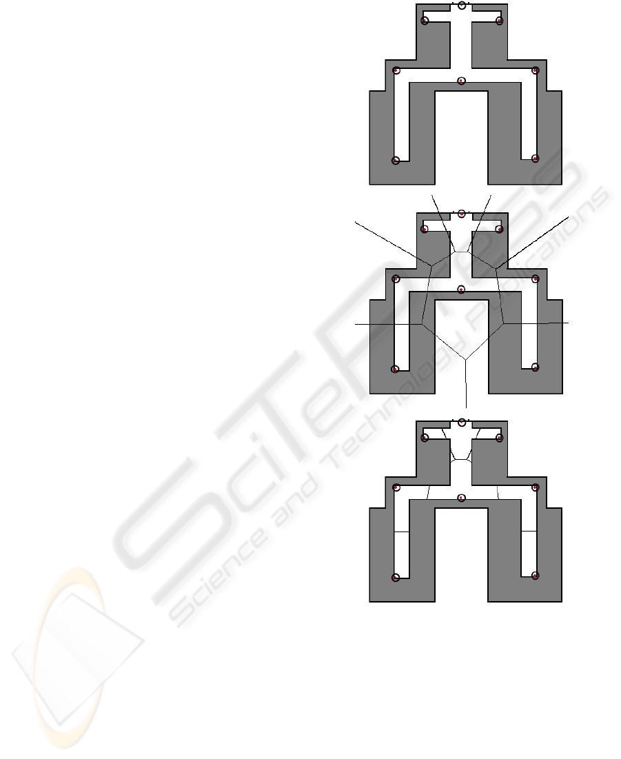
Figure 1: A simple location, access points are the circled
red dots. The center image shows the voronoi regions gen-
erated from the access points. In the bottom picture, the
regions have been clipped to the corridors. Artifact regions
generated during clipping can be seen top center below the
cross corridor.
4 NAVIGATION COMMANDS
FROM APPROXIMATE
POSITIONS
The generation of navigation commands must distin-
guish two types of navigation tasks:
INDOOR NAVIGATION USING APPROXIMATE POSITIONS
169

Long Paths have endpoints located in different sec-
tors. Finding such paths in the graph representa-
tion is a simple application of the A* algorithm,
(Russel and Norvig, 2003; S
´
anchez-Crespo Dal-
mau, 2003). This type of path is represented as a
series of adjacent sectors. Long paths can be dis-
played graphically, laid over the map.
Short Paths remain inside a sector. As long paths
can be expressed as a series of short ones,
generating succinct instructions for the latter is
paramount.
For long paths, position information can deter-
mine the sector where the mobile device is located.
Using this information, it is possible to restrict the
navigation instructions to the current location. For
short paths, position information is at best an approx-
imation and fine grained instructions like “take the
next corridor to the right” are not feasible. Natu-
ral language allows the use of coarse grained
3
rela-
tive instructions: Instead of alerting the user when no
misunderstanding is possible, a navigation instruction
should unambiguously describe the target, the corri-
dor in this case.
Natural Language Instructions are attractive for
this application (Reiter, 2000; Kray and Blocher,
1999), as their rich descriptive abilities are able to sin-
gle out targets from a group, if instructions are con-
structed with care. This can be be done using adjec-
tives which apply to the target (e.g. “the green Col-
umn” or “the leftmost door”), or by giving a spatial re-
lationship to a Landmark (see e.g. (Elias et al., 2005;
Tversky and Lee, 1999; Lazkano et al., 2005)).
The lack of rigidly detailed instructions may seem
inappropriate when navigation instructions are con-
sidered from the point of view of a car’s driver. For
example the instruction “take the next turn left” al-
ways refers to a road for cars, but a pedestrian could
turn left into a store. As pedestrians are less con-
strained than cars in their movement, usually travers-
ing areas (Gaisbauer and Frank, 2008), the construc-
tion of “short paths” is predominated by avoiding
clumps of people, fountains and other landmarks as
well as adaption the movement of other pedestrians,
forming flows and eddies
4
. These considerations
show that fine detailed instructions are not as desir-
able for pedestrians as they may be for cars: Navigat-
ing across a plaza filled with a milling crowd is best
left to a humans cognitive abilities.
The remainder of this section elaborates on these
topics.
3
That is, without relying on up-to-date exact positions.
4
Flocking in AI terms.
4.1 Landmarks
Landmarks can be anything, as long as it is easily
seen. Stores and other corporate entities (preferably
with a nice iconic logo) are useful. In cities, Stat-
ues, fountains, buildings, the cologne cathedral and
the tour d’Eiffel, and other elements of the surround-
ings are used which are less interesting for indoors ap-
plications. Staircases, elevators, emergency exits and
phone booths (while they exist) are exemplary of ar-
chitectural features which make for good indoor land-
marks. Navigational targets can also serve as land-
marks, if they are not targets of the current path. Nat-
ural language nicely distinguishes this as e.g. “go to
the booth by the stairs” versus “climb the stairs by the
booth”
Landmarks can be displayed on the map by draw-
ing icons and logos or even images at the appropriate
places. This gives users hints for in-sector naviga-
tion where the approximate positions can not be used
to generate micro-instructions graphically without be-
coming confusing. The graphical representations of
landmarks need to be provided together with the map
information.
Landmarks are regularly used by humans in nat-
ural language instructions. Human languages of-
fer a plethora of ways to express absolute directions
(straight ahead, turn left, in and out), relative locations
(By the stairs, next to the record store) and descrip-
tion (colors, shapes, labels), which can further aid in
in-sector route description.
4.2 Natural Language Instructions
Natural Language is an familiar means to convey in-
formation. It has the capability to convey naviga-
tion information with closer emphasis on significant
or detail. For instance, in the above example (booth
and stairs), natural language can indicate whether the
booth or the stairs, or both, are landmarks, based on
the next way-point. It is also able to generate static
instructions, which where identified as a necessity de-
scribing short paths inside a sector.
Instructions can be fine grained when using spatial
and temporal constructs to aid navigation inside a sec-
tor. Relative instructions can try to determine what is
on the left and what is on the right side, for example
when entering a large hall from a corridor. In gen-
eral, assuming the user walked in a straight line from
the last sector to the current one, directions relative to
the users orientation (like “left” or “right”). As men-
tioned in the example at the beginning of this section,
context based information can be used to place em-
phasis on important elements of the Locations (stairs
WINSYS 2009 - International Conference on Wireless Information Networks and Systems
170

which must be used) and delegating lesser ones to de-
scriptive items, based on the currently scheduled ac-
tivity. Relative descriptions can be used to associate
a target with a mote prominent feature in the close
vicinity.
Annotating landmarks or prominent features of
the locations (e.g. statues or fountains) with descrip-
tive adjectives makes it possible to convey succinct
descriptions of a location or feature.
For a given language, a grammar defines how sen-
tences are formed. While computers are mostly con-
cerned with parsing (Aho et al., 2007), that is under-
standing a language, the generative aspect of gram-
mars is well known. Based on the current way-point
and the next one, as well as the knowledge provided
by the extended map, instructions can be generated by
expanding productions of the grammar based on the
available information. The expansion of productions
is controlled by a set of rules, which take the available
information into account.
Finally, natural language instructions can be used
to convey information related to the users current ac-
tivity, but not the geometry itself. Platform changes,
deadlines like the trains’ departure, and gotchas like
the fact the train will be split at a later stop (only the
back half going to the users destination), can not be
conveyed on a map, and thus benefit from a natural
language interface.
5 CONCLUSIONS
A system for indoor navigation based on the Whisper-
ing technique, which is currently being implemented,
was described. While imprecise, it counteracts prop-
agation effects. This motivates the use of voronoi
diagrams to represent an idealized sectorization of
locations, based on access points provided by local
WLAN infrastructure.
User guidance without precise position informa-
tion relies heavily on natural language instructions.
The graphical representation, while simple and fa-
miliar, provides only an overview of the path. Nat-
ural language instructions are used to provide static
path descriptions where dynamic descriptions would
require a position with more precision than available
using Whispering.
REFERENCES
Aho, A. V., Lam, M. S., Sethi, R., and Ullman, J. D. (2007).
Compilers: Principles, Techniques and Tools, 2nd Ed.
Pearson Education.
Aurenhammer, F. (1991). Voronoi diagrams: A survey of a
fundamental geometric data structure. ACM Comput-
ing Surveys, 23:345–405.
Aurenhammer, F. and Klein, R. (2000). Voronoi diagrams.
In Handbook of Computational Geometry, pages 201–
290. Elsevier Science Publishers B.V. North-Holland.
Barber, C. B. and Dobkin, D. P. (1996). The quickhull algo-
rithm for convex hulls. ACM Transactions on Mathe-
matical Software, 22:469–483.
Elias, B., Pelke, V., and Kuhnt, S. (2005). Concepts for the
cartographic visualization of landmarks.
Gaisbauer, C. and Frank, A. U. (2008). Wayfinding model
for pedestrian navigation.
Kray, C. and Blocher, A. (1999). Modeling the basic mean-
ings of path relations. In Proceedings of the 16th IJ-
CAI, pages 384–389. Morgan Kaufmann.
Krempels, K.-H. and Krebs, M. (2008). Improving
directory-less wlan positioning by device whispering.
Lazkano, E., Astigarraga, A., Sierra, B., inez Otzeta, J.
M. M., and Ra
˜
n
´
o, I. (2005). Natural landmark based
navigation.
Ohlbach, H. J., Rosner, M., Lorenz, B., and Stoffel, E.
(2006). Nl navigation commands from indoor wlan
fingerprinting position data.
Patzak, S. (2009). Aktive wlan positionierung. Master’s
thesis, RWTH Aachen University.
Reiter, E. (2000). Building natural language generation sys-
tems.
Russel, S. and Norvig, P. (2003). Artificial Intelligence: A
Modern Approach, 2nd Ed. Pearson Education.
S
´
anchez-Crespo Dalmau, D. (2003). Core Techniques and
Algorithms in Game Programming. New Riders Pub-
lishing.
Tversky, B. and Lee, P. U. (1999). Pictorial and verbal tools
for conveying routes. Springer.
INDOOR NAVIGATION USING APPROXIMATE POSITIONS
171
